Land at Ingoldfield Lane, Soberton, SO32
- Land size
- 1.24 acres
Key Features
- LAND TOTALLING 1.24 ACRES (0.50 HA)
- A UNIQUE OPPORTUNITY TO ACQUIRE LAND WITH PLANNING APPROVAL FOR 2 HOLIDAY LODGES
- OFFERS INVITED FOR THE FREEHOLD WITH VACANT POSSESSION
Description
:
The property comprises two field parcels of permanent grassland extending to 1.25 acres (0.50ha). The land benefits from planning approval for two holiday lodges.
The land is rectangular in shape and gently slopes from west to east. The property has mature hedgerow boundaries on two sides, with a post and rail fence on the remaining two sides. The property is accessed via a 12ft field gate from Ingoldfield Lane.
The holiday lodges are proposed to have a GIA of 61.4m2 (661ft2) each.
The soils are freely draining slightly acid loamy soils. The land has previously been used for equestrian grazing.
The land offers a quiet setting, well screened from the public highway and offers a unique opportunity to purchase land in a rural location with the ability to earn an income from holiday accommodation.
PLANNING
The property benefits from planning permission for the erection of 2 two-bedroomed timber-clad holiday lodges. Winchester Planning Authority reference: 22/01722/FUL as approved on 8th February 2023.
A subsequent non-material minor amendment was approved 19th March 2024, Winchester Planning Authority Reference 24/00251/NMA, to permit 2 three-bedroom holiday lodges on the same footprint.
There is a planning condition which limits the use of the lodges to holiday accommodation only.
A copy of all planning documents are available from the Selling Agent.
LOCATION:
The land is located in open countryside, outside of the South Downs National Park. The land benefits from good outriding on the local lane and bridleway network. Location and Site Plans over.
DIRECTIONS:
From Wickham, take the A32 towards Droxford, after 1.7 miles turn right onto Heath Lane. After 1.5 miles turn right onto Chapel Road, after 0.5 miles turn left onto May Bush Lane and then first right onto Ingoldfield Lane. The land is situated on the right hand side after Meadow View Cottage.
From Waterlooville, take Forest Road towards North Boarhunt. At Shoot Hill, turn right towards Newtown, continue for 1.2 mile, turn right onto Ingoldfield Lane, continue for 1 mile the land is situated on the left hand side, with the access opposite Ingoldfield House.
What3Words App is :///alright.motivator.doctor
VIEWING:
Viewing is possible without appointment at any time during daylight hours so long as prospective purchasers are in possession of a set of these Sale Particulars. The roadside gate will remain locked during marketing, if you require access, please contact the Selling Agent.
TITLE:
The property has Registered Title with HM Land Registry, Title No. HP506707.
SERVICES:
Mains water is connected to the land via a metered supply. Electricity is believed to be available in the public highway. Purchasers should undertake their own investigation into service availability.
ACCESS:
The land is accessed via a gated entrance from the public highway known as Ingoldfield Lane
TENURE AND POSSESSION:
Freehold with Vacant Possession.
METHOD OF SALE:
The Vendor invites offers for the property by Private Treaty. Prospective purchasers should register their interest with the Selling Agents to whom offers should be submitted.
For further information, please contact the Selling Agents.
PRICE GUIDE: £350,000
CONTACT:
Ian Judd & Partners LLP - Henry Brice
ANTI MONEY LAUNDERING COMPLIANCE
In accordance with the Money Laundering, Terrorist Financing and Transfer of Funds (Information on the Payer) Regulations 2017, the Selling Agents are required to undertake due diligence on property purchasers. Once an offer has been accepted, the prospective purchaser(s) will need to provide, as a minimum, proof of identity and residence, proof of source of funds for the purchase, and complete a purchasers questionnaire before the transaction can proceed.
IMPORTANT NOTICE: Ian Judd and Partners LLP and their Clients give notice that:
1.They are not authorised to make or give any representations or warranties in relation to the property either here or elsewhere, either on their own behalf or on behalf of their client or otherwise. They assume no responsibility for any statement that may be made in these particulars. These particulars do not form part of any offer or contract and must not be relied upon as statements or representations of fact.
2. Any areas, measurements or distances are approximate. The text, photographs and plans are for guidance only and are not necessarily comprehensive. It should not be assumed that the property has all necessary planning, building regulation or other consents and Ian Judd and Partners have not tested any services, equipment or facilities. Purchasers must satisfy themselves by inspection or otherwise.
3. The reference to any mechanical or electrical equipment or other facilities at the property shall not constitute a representation (unless otherwise stated) as to its state or condition or that it is capable of fulfilling its intended function and prospective purchasers/tenants should satisfy themselves as to the fitness of such equipment for their requirements. We have not made any investigations into the existence or otherwise of any issues concerning pollution of land, air or water contamination and the purchaser is responsible for making his own enquiries in this regard.
4. Tax may be payable in addition to the purchase price of any property according to law. Ian Judd and Partners is a Limited Liability Partnership.
May 2024
Map Location
Property details
- Tenure
- Freehold
- Council Tax Band
- Ask Agent
- Date Posted
- 2026-01-29
Market Value Analysis
Compared with 98 Bare & Undeveloped Land listings in South East England (1+ acres).
Utilities & Restrictions
Utilities
- Electricity
- Ask Agent
- Water
- Ask Agent
- Heating
- Ask Agent
- Broadband
- Ask Agent
- Sewerage
- Ask Agent
Rights & Restrictions
- Public Rights of Way
- Ask Agent
- Private Rights of Way
- Ask Agent
- Listed Property
- Ask Agent
- Restrictions
- Ask Agent
Listed status, conservation areas and planning constraints for this location are in the full report.
Property Features
- Accessibility
- Ask Agent
- Parking
- Ask Agent
- Garden
- Ask Agent
Beyond the particulars: planning activity, flood history, heritage and ground risks, checked for this exact spot.
Connectivity
Broadband
Fastest speed available at this postcode
1.8 Gbps
Gigabit full fibre · available to 88% of premises
Suitable for
- 4K streaming on every screen
- Full-time home working
- Online gaming & big downloads
Mobile signal
Predicted 4G and 5G signal; indoor signal depends on building materials.
Ofcom Connected Nations postcode-level predictions. Speeds and signal are modelled, not measured, and vary between addresses and providers.
Signal is the easy part. Planning activity, flood history and protected designations here are in the full report.
Nearest Schools
Primary
- Newtown Soberton Infant School1.1 milesOfsted: Good *
- Ages
- 4 to 7
- Pupils
- 73
- Type
- Community school
- Hambledon Primary School2.2 milesOfsted: Good *
- Ages
- 4 to 11
- Pupils
- 95
- Type
- Community school
- Droxford Junior School2.4 milesOfsted: Outstanding
- Ages
- 7 to 11
- Pupils
- 164
- Type
- Academy converter
- Swanmore Church of England Aided Primary School2.5 milesNo Ofsted rating
- Ages
- 4 to 11
- Pupils
- 409
- Type
- Voluntary aided school
- Faith
- Church of England
- Wickham Church of England Primary School3 milesOfsted report card · Mar 2026
- Ages
- 4 to 11
- Pupils
- 300
- Type
- Voluntary controlled school
- Faith
- Church of England
Secondary
- Swanmore College2.7 milesNo Ofsted rating
- Ages
- 11 to 16
- Pupils
- 1,338
- Type
- Community school
- The Cowplain School5.2 milesOfsted: Good
- Ages
- 11 to 16
- Pupils
- 993
- Type
- Academy converter
- Castle View Academy5.4 milesOfsted report card · Jun 2026
- Ages
- 11 to 16
- Pupils
- 757
- Type
- Academy converter
- Cams Hill School5.4 milesOfsted: Good
- Ages
- 11 to 16
- Pupils
- 1,265
- Type
- Academy converter
- Horndean Technology College5.4 milesOfsted: Good *
- Ages
- 11 to 16
- Pupils
- 1,288
- Type
- Community school
* Latest graded judgement covers quality of education only; no overall grade was issued under the 2024-25 inspection framework.
Distances are straight-line from the advertised location. Source: the national school registers (DfE, Welsh Government, Scottish Government) and Ofsted.
Schools are just the start: sold prices nearby, planning activity and any flood history are in the full report.
Amenities
Supermarket
GP surgery
Pharmacy
Hospital
Green space
Straight-line distances from the advertised location. Sources: NHS records, Geolytix supermarket locations, OS Open Greenspace and the national trails registers.
The area stacks up? Now check the location itself: planning nearby, protected designations and past flooding.
Getting Around
Nearest station
Nearest bus stop
Typical drive times
Straight-line distances from the advertised location; drive times are typical free-flow times over OpenStreetMap road data, so allow more at peak. Public transport locations from DfT NaPTAN.
Easy to reach matters. So do planning activity, flood history and ground risks: all in the full report.
Flood Risk
Environment Agency open data, checked around the advertised map pin for the listed acreage. Long-term risk counts flood defences; the planning map's flood zones do not. Provided by LandSale, not the listing agent, and not part of the agent's particulars. Risk varies across a holding, so verify before committing.
Rivers and the sea
Planning map: Flood Zone 1.
Surface water
Not at the pin: mapped about 10 metres away.
These bandings are the summary. Where this location sits on the flood maps, plus planning activity, heritage and ground risks, is in the full report.
Important notice: Information, maps and tags on this page are drawn from the advertising agent's marketing materials or generated automatically. LandSale has not verified them. Relying on these details is at your own risk, always carry out independent checks before committing to a purchase.
LandSale full disclaimer
Marketing information only - not formal particulars. The details on this website are provided for general guidance and do not constitute an offer or contract. Neither LandSale nor the advertising estate/land agent accepts responsibility for any inaccuracy.
1. Source of information
- Listing content: Core description, asking price, tenure, measurements, photographs and planning history originate from the marketing materials of the advertising estate or land agent. LandSale does not author this content and cannot guarantee its accuracy.
- Automated tags & categorisation: Property type, land-use class, acreage bands and similar labels may be applied by machine-learning models. They are intended as a helpful guide only and may not reflect the property's legal status or permitted use.
- Third-party & enriched data layers: Maps, boundary outlines, planning designations, soil reports, broadband coverage and other environmental or location-based insights are licensed from external suppliers. Such data are supplied “as is", may be incomplete or out of date and are subject to change without notice.
2. Verification required
Prospective purchasers must verify critical matters, including but not limited to planning permission, title boundaries, public rights of way, environmental constraints, acreage, services, access and VAT status, through their own inspections, specialist surveys, legal advisers and the selling agent before relying on the information or entering into any contract.
3. No warranty or liability
LandSale gives no warranty, express or implied, as to the accuracy, completeness or fitness for any particular purpose of the information displayed. LandSale shall not be liable for any loss, damage, cost or expense arising directly or indirectly from any use of or reliance on such information, save where liability may not be excluded by law.
4. Updates & feedback
If you believe any detail on this listing is inaccurate, please let us know. We will investigate and, where appropriate, update the listing or notify the agent.
© LandSale | Version 1.3 - August 2026
Listing agent
Ian Judd & Partners, Bishops Waltham
4 High Street, Bishops Waltham, Southampton, SO32 1AB
Contact Ian Judd & Partners, Bishops Waltham
4 High Street, Bishops Waltham, Southampton, SO32 1AB
View agent profileSimilar properties for sale
- Price
- Guide Price£375,000
- Size
- 11.88 acres
Added on 29/01/2026Equestrian property
- Price
- Guide Price£300,000
- Size
- 7.12 acres
Butts Farm, Rareridge Lane, SO32, Bishops Waltham, Hampshire SO32 England
Added on 29/01/2026Pasture
- Price
- Guide Price£365,000
- Size
- 5.55 acres
Fontley Road, Fareham, Hampshire, PO15, Wickham and Knowle, Hampshire PO15 England
Added on 29/01/2026Equestrian property
- Price
- Guide Price£385,000
- Size
- 2.5 acres
Added on 11/09/2026Agricultural Land
- Price
- Guide Price£350,000
- Size
- 5.1 acres
Glen Road, Sarisbury Green, Hampshire, Hamble Valley, Hampshire SO31 England
Added on 11/07/2026Agricultural Land
- Price
- Guide Price£290,000
- Size
- 9.75 acres
Stoner Hill Road, GU32, Froxfield and Privett, Hampshire GU32 England
Added on 29/01/2026Pasture
- Price
- Guide Price£390,000
- Size
- 10.84 acres
Stoner Hill Road, GU32, Froxfield and Privett, Hampshire GU32 England
Added on 29/01/2026Pasture
- Price
- £290,000
- Size
- 19.28 acres
Land at Heytesbury Farm, Newport and Carisbrooke, Isle of Wight PO30 England
Added on 29/01/2026Agricultural Land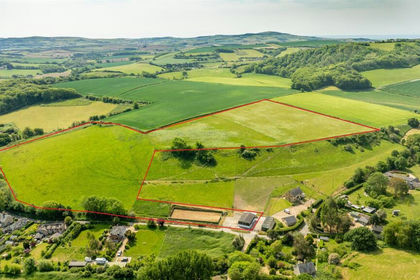
- Price
- Guide Price£350,000
- Size
- 18.33 acres
Added on 25/06/2026Agricultural Land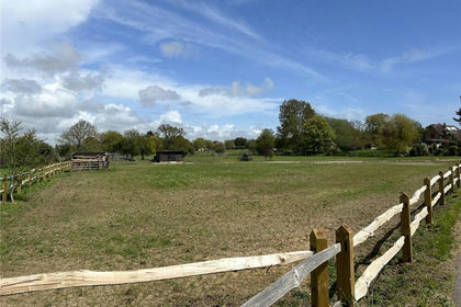 Added on 18/06/2026Agricultural Land