Booth Bed Lane, Allostock, WA16
- Bedrooms
- 6
- Bathrooms
- 3
Key Features
- A fabulous barn conversion with large garden and separate two bedroom annex
- An exceptional barn conversion with two bedroom annex
- Superb rural location between Knutsford and Goostrey
- In all six bedrooms, five receptions, about 3000sf in all
Description
A superb, beautifully finished barn conversion with an excellent and very useful separate two bedroomed self contained annex, in a lovely rural location positioned between Knutsford and Goostrey, boasting around 3000 square feet in all, with excellent private parking and large landscaped gardens.
The Barns at Allostock were converted in 2016 to an exceptional standard and provide a wonderful combination of period character and contemporary living. They are a particularly fine example of the sensitive conversion of historic buildings, retaining their original character while incorporating a high level of modern specification. The scheme comprises six houses, with two separate driveways, this property is at the far end of the development with lots of private parking and a very large garden.
The two corner properties occupy the best positions, with Number 3 arguably enjoying the prime setting. It has excellent private parking to the front, together with the large wraparound garden extending to two sides and enjoying super views over surrounding open fields.
The accommodation is beautifully presented throughout, with high-quality fittings and finishes, underfloor heating in part and including an excellent hand-painted kitchen by local cabinet makers Hetherington Newman of Knutsford. The layout flows particularly well and provides excellent flexibility for modern family living.
There are three reception areas in the main house, including a lovely dual-aspect sitting room with exposed timbers and a wood-burning stove, a large study or snug and a large dining/hall which is open plan to the kitchen and utility room. The hand-painted kitchen has a central island and forms the heart of the house, and a glazed garden room/family room has been added, opening directly from the kitchen area and it transforms the ground floor completely. Bathed in natural light, it has glazing to two sides overlooking the gardens, and provides a lovely additional living space.
At first-floor level there are four bedrooms. The principal bedroom is particularly impressive, being spacious and light with a high ceiling, exposed timbers and a dual aspect. It has a beautifully appointed en suite shower room with high-quality fittings, while the adjacent bedroom has been fitted out as a dressing room, creating an excellent arrangement for the principal suite.
There are two further double bedrooms, both with fitted wardrobes, together with a well-appointed family bathroom incorporating a three-piece suite and shower over the bath.
To the front of the property is a generous private parking area and driveway, providing space for four or five cars, together with a double open car barn. Attached to this is a former double garage which has been converted and extended to create a superb self-contained two bedroom annexe of approximately 670 sq ft. The annexe is an excellent addition to the property, comprising a spacious lounge/dining room, two separate bedrooms, and a kitchen and bathroom. It is presented to a good standard, enjoys views over the garden and has its own private outdoor area. Providing genuinely useful additional accommodation for a long-term guest, relative or independent family member, an annexe of this quality and size is highly unusual at this level of the market.
The location is equally appealing. The development lies on the outskirts of Goostrey village, within just a few hundred metres of the Trading Post, an excellent village store, while Knutsford is only approximately five to seven minutes away by car. The combination of the superb setting, period character, exceptional presentation, generous gardens, parking and unusually good ancillary accommodation makes Number 3 a particularly attractive home.
EPC Rating: D
Map Location
Property details
- Tenure
- Freehold
- Council Tax Band
- F
- Date Posted
- 2026-10-05
Energy Performance Certificate
Energy Efficiency Rating
Based on UK Energy Performance Certificate standards (EU Directive 2002/91/EC)
Running costs are one side. Planning activity, flood history and ground risks for this location are in the full report.
Utilities & Restrictions
Utilities
- Electricity
- Mains
- Water
- Mains
- Heating
- Electric Heating, Gas Central Heating, Wood Burner
- Broadband
- Fibre (FTTC)
- Sewerage
- Septic Tank / Private
Rights & Restrictions
- Public Rights of Way
- Ask Agent
- Private Rights of Way
- Yes
- Listed Property
- Ask Agent
- Restrictions
- Ask Agent
Listed status, conservation areas and planning constraints for this location are in the full report.
Property Features
- Accessibility
- Ask Agent
- Parking
- Parking Available
- Garden
- Garden
Beyond the particulars: planning activity, flood history, heritage and ground risks, checked for this exact spot.
Connectivity
Broadband
Fastest speed available at this postcode
900 Mbps
Gigabit full fibre · available to 33% of premises
Suitable for
- 4K streaming on every screen
- Full-time home working
- Online gaming & big downloads
Mobile signal
Predicted 4G and 5G signal; indoor signal depends on building materials.
Ofcom Connected Nations postcode-level predictions. Speeds and signal are modelled, not measured, and vary between addresses and providers.
Signal is the easy part. Planning activity, flood history and protected designations here are in the full report.
Nearest Schools
Primary
- Goostrey Community Primary School1.5 milesOfsted report card · Mar 2026
- Ages
- 4 to 11
- Pupils
- 197
- Type
- Community school
- Lower Peover CofE Primary School2 milesOfsted: Outstanding
- Ages
- 4 to 11
- Pupils
- 208
- Type
- Academy converter
- Faith
- Church of England
- Peover Superior Endowed Primary School2.3 milesNo Ofsted rating
- Ages
- 4 to 11
- Pupils
- 95
- Type
- Academy sponsor led
- Hermitage Primary School2.4 milesOfsted: Good
- Ages
- 4 to 11
- Pupils
- 206
- Type
- Academy converter
- Byley Primary School and Nursery2.5 milesOfsted: Good
- Ages
- 3 to 11
- Pupils
- 88
- Type
- Community school
Secondary
- Holmes Chapel Comprehensive School2.9 milesOfsted: Good
- Ages
- 11 to 18
- Pupils
- 1,311
- Type
- Academy converter
- Knutsford Academy4.4 milesOfsted report card · Mar 2026
- Ages
- 11 to 18
- Pupils
- 1,429
- Type
- Academy converter
- Middlewich High School4.9 milesOfsted: Good
- Ages
- 11 to 16
- Pupils
- 665
- Type
- Academy converter
- The Rudheath Senior Academy5.2 milesNo Ofsted rating
- Ages
- 11 to 16
- Pupils
- 576
- Type
- Academy sponsor led
- The County High School, Leftwich6 milesOfsted report card · Jun 2026
- Ages
- 11 to 16
- Pupils
- 1,046
- Type
- Academy converter
Distances are straight-line from the advertised location. Source: the national school registers (DfE, Welsh Government, Scottish Government) and Ofsted.
Schools are just the start: sold prices nearby, planning activity and any flood history are in the full report.
Amenities
Supermarket
GP surgery
Pharmacy
Hospital
Straight-line distances from the advertised location. Sources: NHS records, Geolytix supermarket locations, OS Open Greenspace and the national trails registers.
The area stacks up? Now check the location itself: planning nearby, protected designations and past flooding.
Getting Around
Nearest station
Nearest bus stop
Typical drive times
Straight-line distances from the advertised location; drive times are typical free-flow times over OpenStreetMap road data, so allow more at peak. Public transport locations from DfT NaPTAN.
Easy to reach matters. So do planning activity, flood history and ground risks: all in the full report.
Flood Risk
Environment Agency open data, checked around the advertised map pin for the listed acreage. Long-term risk counts flood defences; the planning map's flood zones do not. Provided by LandSale, not the listing agent, and not part of the agent's particulars. Risk varies across a holding, so verify before committing.
Rivers and the sea
Planning map: Flood Zone 1.
Surface water
These bandings are the summary. Where this location sits on the flood maps, plus planning activity, heritage and ground risks, is in the full report.
Important notice: Information, maps and tags on this page are drawn from the advertising agent's marketing materials or generated automatically. LandSale has not verified them. Relying on these details is at your own risk, always carry out independent checks before committing to a purchase.
LandSale full disclaimer
Marketing information only - not formal particulars. The details on this website are provided for general guidance and do not constitute an offer or contract. Neither LandSale nor the advertising estate/land agent accepts responsibility for any inaccuracy.
1. Source of information
- Listing content: Core description, asking price, tenure, measurements, photographs and planning history originate from the marketing materials of the advertising estate or land agent. LandSale does not author this content and cannot guarantee its accuracy.
- Automated tags & categorisation: Property type, land-use class, acreage bands and similar labels may be applied by machine-learning models. They are intended as a helpful guide only and may not reflect the property's legal status or permitted use.
- Third-party & enriched data layers: Maps, boundary outlines, planning designations, soil reports, broadband coverage and other environmental or location-based insights are licensed from external suppliers. Such data are supplied “as is", may be incomplete or out of date and are subject to change without notice.
2. Verification required
Prospective purchasers must verify critical matters, including but not limited to planning permission, title boundaries, public rights of way, environmental constraints, acreage, services, access and VAT status, through their own inspections, specialist surveys, legal advisers and the selling agent before relying on the information or entering into any contract.
3. No warranty or liability
LandSale gives no warranty, express or implied, as to the accuracy, completeness or fitness for any particular purpose of the information displayed. LandSale shall not be liable for any loss, damage, cost or expense arising directly or indirectly from any use of or reliance on such information, save where liability may not be excluded by law.
4. Updates & feedback
If you believe any detail on this listing is inaccurate, please let us know. We will investigate and, where appropriate, update the listing or notify the agent.
© LandSale | Version 1.3 - August 2026
Listing agent
Stuart Rushton & Co, Knutsford
35 King Street, Knutsford, Cheshire, WA16 6DW
Contact Stuart Rushton & Co, Knutsford
35 King Street, Knutsford, Cheshire, WA16 6DW
View agent profileSimilar properties for sale
- Price
- £1,375,000
- Size
- 8 acres
Wash Lane, Allostock, Allostock, Cheshire West and Chester WA16 England
Added on 24/06/2026House with Land
- Price
- £1,250,000
- Size
- 1.89 acres
Northwich Road, Cranage, WA16, Cranage, Cheshire East CW4 England
Added on 18/09/2026House with Land
- Price
- £1,000,000
Holmes Chapel Road, Over Peover, WA16, Peover Superior and Snelson, Cheshire East WA16 England
Added on 29/01/2026Barn Conversion
- Price
- £1,200,000
- Size
- 2 acres
Cinder Lane, Over Peover, WA16, Peover Superior and Snelson, Cheshire East WA16 England
Added on 09/04/2026Redevelopment Land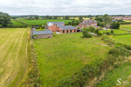
- Price
- £875,000
- Size
- 0.5 acres
Byley Lane, Byley, CW10, Byley, Cheshire West and Chester CW10 England
Added on 20/07/2026Barn Conversion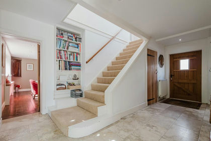 Added on 10/07/2026Barn Conversion
- Price
- Offers Over£1,350,000
- Size
- 1.07 acres
Holmes Chapel Road, CW9, Lach Dennis and Lostock Green, Cheshire West and Chester CW9 England
Added on 29/01/2026House with Land Added on 18/06/2026Barn Conversion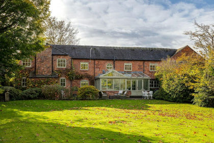
- Price
- Guide Price£1,050,000
- Size
- 1.5 acres
3200 sq ft barn conversion in 1.5 acres, Brereton, Cheshire East CW12 England
Added on 29/01/2026Barn Conversion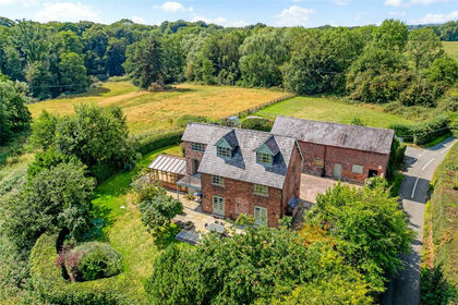
- Price
- Offers Over£1,250,000
- Size
- 4 acres
Plumley, Knutsford, Cheshire, Plumley, Cheshire East WA16 England
Added on 19/08/2026House with Land