Lee Hall Farm, Lee Brockhurst, Shrewsbury
- Land size
- 214.51 acres
- Bedrooms
- 6
- Bathrooms
- 2
Key Features
- First class arable and livestock farm
- Grade II Listed farmhouse of great character
- Extensive range of predominantly modern farm buildings
- Extending to approximately 214.51 acres
- Located in a popular rural hamlet
- For sale as a whole or in lots
Description
A first class arable and livestock farm, superbly situated in the North Shropshire countryside and extending in all to around 214.51 acres.
Situation - Lee Hall Farm is situated in the popular rural hamlet of Lee Brockhurst which is within easy reach of the north Shropshire towns of Wem (4 miles) and Whitchurch (10 miles), both of which have an excellent range of local shopping, recreational and educational facilities. The county town of Shrewsbury lies just 7.5 miles to the south and has a more comprehensive range of amenities of all kinds.
Directions - From the Agent’s office at Battlefield, Shrewsbury, take the A49 northwards for approximately 6.5 miles and turn left, signposted for Lee Brockhurst. Continue for a short distance into the hamlet and the farmhouse can be found on the left-hand side of the road, with the farm buildings located on the right-hand side.
What3Words: //////forces.dinosaur.brilliant
Description - Lee Hall Farm is a well-situated arable and livestock farm. The farm comprises a most attractive Grade II Listed farmhouse of great charm, set in mature gardens extending to over an acre, which include a range of domestic outbuildings. The accommodation is thoughtfully arranged, providing a practical and versatile layout that caters well to family or even multi-generational living.
There is an extensive range of predominantly modern farm buildings affronted by concrete yards, located on the opposite side of the council-maintained road to the farmhouse, which have potential for a variety of alternative uses (subject to Local Authority consents).
The good quality farmland is situated in two principal blocks, extending, in all, to approximately 214.51 acres.
High quality and versatile farms such as this do not come on the market for sale very often in this area, so Halls, the Selling Agents have no hesitation in recommending it for an immediate viewing.
Farmhouse - Dating back to the 17th Century, the farmhouse is an attractive, Grade II listed period residence of great character which is situated at the centre of the farmstead and accessed directly off the council-maintained country lane which runs through the village.
The farmhouse is rich in period charm, with features such as traditional fireplaces and exposed beams combining to create a spacious and inviting family home. The accommodation is divided over two floors with a wide entrance hall, three charming reception rooms, a dining room, a farmhouse kitchen, a conservatory and a useful pantry / back kitchen area.
The conservatory provides access to further ground floor rooms including a utility, shower room and second staircase leading to the first floor and onwards to the attic.
The first floor comprises a large split-level landing together with five/six generously sized bedrooms and a family bathroom.
Outside - The surrounding gardens include a gravelled car parking area and extensive lawns with ornamental ponds, shrub borders and mature/semi-mature trees.
A beautiful traditional red brick building is situated adjacent to the house and includes a garage, storage/workshop space and a former “shoot room” with a fireplace, open plan living / kitchen area, conservatory and bathroom. This also has great potential for alternative usages such as multi-generational living or conversion (subject to Local Authority consents).
Farm Buildings - The farm buildings are situated across the lane from the farmhouse and are principally set around concrete yards. They include a useful range of modern buildings that have been used for livestock housing and machinery storage in recent years and which could present an opportunity for alternative uses (subject to Local Authority consents).
Land - The land is a major feature of the property and comprises approximately 187.40 acres of arable and grassland, with good access off quiet council-maintained roads.
The land is both versatile and productive with the majority classed as Grades 2 and 3 on the Agricultural Land Classification Map for England and Wales.
For land schedule, please see attached brochure.
Tenure - We understand that the property is of freehold tenure and vacant possession will be given upon completion.
Probate - The property is being sold on behalf of the Executors of the Estate of Mr J Bowen (Deceased), and therefore exchange of contracts can only take place after Grant of Probate.
Method Of Sale - The property is offered for sale by Private Treaty, as a whole or in lots.
Services - We understand the property has the benefit of mains electricity together with private drainage and a private borehole water supply. We further understand there is mains water in the road outside the farmhouse.
Anti-Money Laundering Checks - We are legally obligated to undertake anti-money laundering checks on all property purchasers. Whilst we are responsible for ensuring that these checks, and any ongoing monitoring, are conducted properly; the initial checks will be handled on our behalf by a specialist company, Movebutler, who will reach out to you once your offer has been accepted. The charge for these checks is £36 (including VAT) per purchaser, which covers the necessary data collection and any manual checks or monitoring that may be required. This cost must be paid in advance, directly to Movebutler, before a memorandum of sale can be issued, and is non-refundable. We thank you for your cooperation.
Rights Of Way, Easements & Covenants - The property will be sold subject to any wayleaves, public or private rights of way, easements and covenants and all outgoings whether mentioned in these sales particulars or not.
Boundaries, Roads & Fences - The Purchaser shall be deemed to have full knowledge of the boundaries and neither the Vendors nor their Agents will be responsible for defining any ownership of boundaries, hedges or fences. They will however provide whatever assistance they can to ascertain the ownership of the same.
Overage - Field Number 7418 and the Farm Buildings will be sold subject to an Overage provision whereby if planning permission is obtained for any non-agricultural or equestrian usage in the next 30 years, then 30% of the uplift in value will be payable to the vendor.
Planning - The property will be sold subject to any development plan, tree preservation order, town planning schedule, resolution or notice which may be or come to be in force, subject to any road or widening or improvement schemes, land charges and statutory or provisional by-laws, without any obligation on the Vendors to specify them.
Local Authority - Shropshire Council, The Guildhall, Frankwell Quay, Shrewsbury, Shropshire, SY3 8HQ. Tel:
Council Tax - We understand the property is Council Tax Band ‘G’.
Energy Performance Certificate - We understand the EPC rating is ‘E’.
Environmental Stewardship - We understand the land is subject to the current Tenant’s Sustainable Farming Incentive (SFI) agreement however the actions do not impact on the sale of the farm.
Nitrate Vulnerable Zone (Nvz) - We understand that the farm is located in a Nitrate Vulnerable Zone.
Sporting Rights - As far as we are aware, the sporting rights are in hand and will be transferred to the Purchaser. Purchasers must verify this for themselves.
Mines & Minerals - As far as we are aware the mine and mineral rights are in hand and will be transferred to the Purchaser. Purchasers must verify this for themselves.
Viewing - Viewings will be accompanied and are strictly by prior appointment with the selling Agents, Halls.
Sole Agents - Allen Gittins FRICS - Email:
Louise Preece BSc (Hons) MRICS FAAV - Email:
Laura Parry-Jones MSc-Email:
Tel:
Map Location
Property details
- Tenure
- Freehold
- Council Tax Band
- G
- Date Posted
- 2026-09-15
Market Value Analysis
Compared with 19 Farms & Smallholdings listings in West Midlands (100+ acres).
Energy Performance Certificate
Energy Efficiency Rating
Based on UK Energy Performance Certificate standards (EU Directive 2002/91/EC)
Running costs are one side. Planning activity, flood history and ground risks for this location are in the full report.
Utilities & Restrictions
Utilities
- Electricity
- Mains
- Water
- Private Supply
- Heating
- Oil Heating, Wood Burner
- Broadband
- Ask Agent
- Sewerage
- Ask Agent
Rights & Restrictions
- Public Rights of Way
- Ask Agent
- Private Rights of Way
- Ask Agent
- Listed Property
- Yes
- Restrictions
- Ask Agent
Listed status, conservation areas and planning constraints for this location are in the full report.
Property Features
- Accessibility
- Ask Agent
- Parking
- Parking Available
- Garden
- Garden
Beyond the particulars: planning activity, flood history, heritage and ground risks, checked for this exact spot.
Connectivity
Broadband
Fastest speed available at this postcode
300 Mbps
Gigabit full fibre · available to 17% of premises
Suitable for
- 4K streaming
- Video calls
- Home working
Fixed wireless access may also be an option here.
Mobile signal
Outdoor predictions; indoor signal depends on building materials.
Ofcom Connected Nations postcode-level predictions. Speeds and signal are modelled, not measured, and vary between addresses and providers.
Signal is the easy part. Planning activity, flood history and protected designations here are in the full report.
Nearest Schools
Primary
- St Peter's CofE Primary School2.3 milesOfsted: Good
- Ages
- 2 to 11
- Pupils
- 404
- Type
- Academy converter
- Faith
- Church of England
- Clive CofE Primary School2.7 milesNo Ofsted rating
- Ages
- 3 to 11
- Pupils
- 93
- Type
- Academy converter
- Faith
- Church of England
- Lower Heath CofE Primary School3.9 milesOfsted: Good
- Ages
- 2 to 11
- Pupils
- 105
- Type
- Academy converter
- Faith
- Church of England
- Prees CofE Primary School3.9 milesNo Ofsted rating
- Ages
- 2 to 11
- Pupils
- 194
- Type
- Academy converter
- Faith
- Church of England
- St Marys CofE Primary School4 milesNo Ofsted rating
- Ages
- 2 to 11
- Pupils
- 226
- Type
- Academy converter
- Faith
- Church of England
Secondary
- The Thomas Adams School2.6 milesOfsted: Good
- Ages
- 11 to 18
- Pupils
- 1,214
- Type
- Academy converter
- Shrewsbury Academy7.8 milesOfsted: Requires improvement
- Ages
- 11 to 16
- Pupils
- 817
- Type
- Academy converter
- The Corbet School8 milesNo Ofsted rating
- Ages
- 11 to 16
- Pupils
- 691
- Type
- Academy converter
- Sir John Talbot's School8.2 milesOfsted: Good
- Ages
- 11 to 19
- Pupils
- 861
- Type
- Academy sponsor led
- Belvidere School9.2 milesOfsted: Requires improvement *
- Ages
- 11 to 16
- Pupils
- 830
- Type
- Academy converter
* Latest graded judgement covers quality of education only; no overall grade was issued under the 2024-25 inspection framework.
Distances are straight-line from the advertised location. Source: the national school registers (DfE, Welsh Government, Scottish Government) and Ofsted.
Schools are just the start: sold prices nearby, planning activity and any flood history are in the full report.
Amenities
Supermarket
GP surgery
Pharmacy
Hospital
Straight-line distances from the advertised location. Sources: NHS records, Geolytix supermarket locations, OS Open Greenspace and the national trails registers.
The area stacks up? Now check the location itself: planning nearby, protected designations and past flooding.
Getting Around
Nearest station
Nearest bus stop
Typical drive times
Straight-line distances from the advertised location; drive times are typical free-flow times over OpenStreetMap road data, so allow more at peak. Public transport locations from DfT NaPTAN.
Easy to reach matters. So do planning activity, flood history and ground risks: all in the full report.
Flood Risk
From Environment Agency flood map open data, checked around the advertised map pin and allowing for the listed acreage where known. This summary comes from LandSale, the advertising platform, not from the listing agent, and is not part of the agent's particulars. Risk can vary across a single holding, so verify anything critical through your own searches before committing.
Rivers and the sea
Mapped within the area searched, not at the advertised map pin itself.
Surface water
Mapped within the area searched, not at the advertised map pin itself.
These bandings are the summary. Where this location sits on the flood maps, plus planning activity, heritage and ground risks, is in the full report.
Important notice: Information, maps and tags on this page are drawn from the advertising agent's marketing materials or generated automatically. LandSale has not verified them. Relying on these details is at your own risk, always carry out independent checks before committing to a purchase.
LandSale full disclaimer
Marketing information only - not formal particulars. The details on this website are provided for general guidance and do not constitute an offer or contract. Neither LandSale nor the advertising estate/land agent accepts responsibility for any inaccuracy.
1. Source of information
- Listing content: Core description, asking price, tenure, measurements, photographs and planning history originate from the marketing materials of the advertising estate or land agent. LandSale does not author this content and cannot guarantee its accuracy.
- Automated tags & categorisation: Property type, land-use class, acreage bands and similar labels may be applied by machine-learning models. They are intended as a helpful guide only and may not reflect the property's legal status or permitted use.
- Third-party & enriched data layers: Maps, boundary outlines, planning designations, soil reports, broadband coverage and other environmental or location-based insights are licensed from external suppliers. Such data are supplied “as is", may be incomplete or out of date and are subject to change without notice.
2. Verification required
Prospective purchasers must verify critical matters, including but not limited to planning permission, title boundaries, public rights of way, environmental constraints, acreage, services, access and VAT status, through their own inspections, specialist surveys, legal advisers and the selling agent before relying on the information or entering into any contract.
3. No warranty or liability
LandSale gives no warranty, express or implied, as to the accuracy, completeness or fitness for any particular purpose of the information displayed. LandSale shall not be liable for any loss, damage, cost or expense arising directly or indirectly from any use of or reliance on such information, save where liability may not be excluded by law.
4. Updates & feedback
If you believe any detail on this listing is inaccurate, please let us know. We will investigate and, where appropriate, update the listing or notify the agent.
© LandSale | Version 1.3 - August 2026

Listing agent
Halls Estate Agents, Property Auctions & Rural Sales
Halls Holdings House Bowmen Way Battlefield Shrewsbury SY4 3DR
Contact Halls Estate Agents, Property Auctions & Rural Sales
Halls Holdings House Bowmen Way Battlefield Shrewsbury SY4 3DR
View agent profileSimilar properties for sale

- Price
- Offers in Region of£2,500,000
- Size
- 7 acres
Shooters Hill Hall, Shrewsbury, Clive, Shropshire SY4 England
Added on 13/06/2026Country Home
- Price
- £2,200,000
- Size
- 5 acres
Meadow View Manor Lighteach Road Prees Whitchurch Shropshire SY13, Prees, Shropshire SY13 England
Added on 29/01/2026Farmhouse
- Price
- Offers Over£2,250,000
- Size
- 147 acres
Fenns Wood House, Fenns Lane, Whixall, Whitchurch, SY13, Bronington, Wrexham SY13 Wales
Added on 01/08/2026Farm
- Price
- Guide Price£3,600,000
- Size
- 33 acres
Tedsmore, Nr Oswestry., Ruyton-XI-Towns, Shropshire SY11 England
Added on 01/05/2026Country Estate
- Price
- Guide Price£2,500,000
- Size
- 8 acres
Dovaston, Kinnerley, Shropshire, Kinnerley, Shropshire SY10 England
Added on 13/06/2026Equestrian property
- Price
- Guide Price£2,000,000
- Size
- 3 acres
Audlem Road, Woore, Crewe, Shropshire, CW3, Woore, Shropshire CW3 England
Added on 23/05/2026House with Land
- Price
- Offers in Excess of£2,500,000
- Size
- 9 acres
Sevenoakes, Hearns Lane, Faddiley CW5, Faddiley, Cheshire East CW5 England
Added on 08/04/2026House with Land
- Price
- Offers in Excess of£2,000,000
- Size
- 13 acres
Lodge Lane, Hatherton, Nantwich, CW5, Hatherton, Cheshire East CW5 England
Added on 02/07/2026Country Estate
- Price
- Offers Over£2,500,000
- Size
- 7.17 acres
Bickerton, Malpas, Cheshire, Bickerton, Cheshire East SY14 England
Added on 27/08/2026House with Land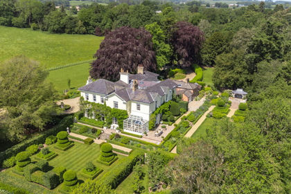
- Price
- £3,000,000
- Size
- 11.05 acres
Penylan, Oswestry, SY10, Oswestry Rural, Shropshire SY10 England
Added on 18/06/2026Country Home