"Woodmans Meadow", Winchester Road, Lower Upham, SO32
- Land size
- 3.25 acres
Key Features
- 3.25 ACRES (1.316 HA)
- STABLING, YARD WITH PERMISSION FOR MANEGE
- FREEHOLD
- LOWER UPHAM
Description
LOCATION:
Woodmans Meadow lies to the south of the B2177 Winchester Road in the very centre of the village of Lower Upham, midway between Fishers Pond to the north west and Bishops Waltham to the south east - both about 2 miles distant.
The Land lies on the boundary and within the South Downs National Park and within the Winchester City Council Local Authority Area. The Property is very well located and within only 20 minutes drivetime of Winchester, Eastleigh, Wickham and Fareham and within 12 miles or so of the centre of Southampton and via the M27 to Portsmouth. Both the M3 and M27 are within 15 minutes drivetime.
SITUATION:
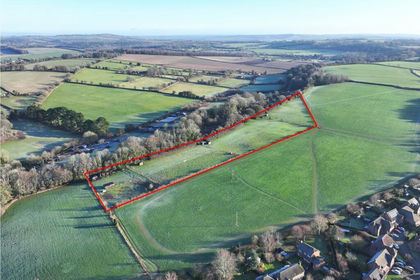
Woodmans Meadow is situated on the south side of Winchester Road, Lower Upham with an extensive frontage of about 98m as well as onto Sciviers Lane, Lower Upham of about 106m from which there is a wide, double-gated entrance bellmouth and from there, the access drive down to the Stables and Yard area, and approved manege.
GENERAL DESCRIPTION:
Woodmans Meadow comprises a total of about 3.25 acres (1.316 ha) of level pastureland suitable for grazing and hay-making and with full Consent and Approval from the Local Planning Authority for equestrian use and occupation.
The recently erected stables include 2 stables with large feed store which could be used as a 3-stable block and is of timber framed and clad construction with cement floors, and onduline roofing - this stabling is brand new and unused.
The meadow has the benefit of a now well-established double galvanised gated entrance and deep and wide bellmouth providing easy access in and out of the property.
The land adjoins commercial and farming premises to the south and a mainly residential built up frontage to the north and east.
The property has the benefit of the laying out of an area of substantial hardstanding and access track from the edge of the public highway, all the way through to the stables and yard area and which will also serve the outdoor exercise area; some of the boundaries have recently had new native hedgerow planting completed as well as post and rail boundary fencing.
PLANNING:
Planning permission was granted for the Change of Use of this Land to Private Equestrian, and erection of Stables with Feed Room (Planning Ref: SDNP/23/03916/FUL - which was Approved on 17th February 2025. Condition 12 of this Consent reads as follows... "The development hereby permitted shall be restricted to the keeping of horses for private recreational use by the owner of the land only and shall not at any time be used for any other form of equestrian activity such as for any commercial riding, breeding or training purposes".
Further planning permission was granted for an "Outdoor Exercise Area" (manege/school) on the same site as shown on the plans attached under Planning Ref: SDNP/25/03022/FUL. A similar condition restricting the use of the School for private recreational use by the owner of the land only applies to that approval too which was granted on 8th January 2026. The approximate siting for the arena is shown with white painted wooden pegs.
SERVICES:
Mains electricity and water supplies are already connected to the property and to the Stables/Yard area. Water Standpipe.
LAND REGISTRY:
The land is registered with the Land Registry under Title No. HP629149 and the property is offered for sale freehold with vacant possession.
WAYLEAVE:
The land is crossed by low voltage overhead SSE electric cabling with poles and stays and the underground mains water pipes and electricity cables which do not affect the use and occupation of the land in anyway.
VIEWING:
The land can be viewed at any time during daylights hours, on foot only whilst in possession of a set of these Sale Particulars.
CONTACT:
Tim Gardner at Ian Judd and Partners LLP - see Brochure for full contact details
DIRECTIONS:
What3Words /// asks.torso.slogged
IMPORTANT NOTICE: Ian Judd and Partners LLP and their Clients give notice that:
1.They are not authorised to make or give any representations or warranties in relation to the property either here or elsewhere, either on their own behalf or on behalf of their client or otherwise. They assume no responsibility for any statement that may be made in these particulars. These particulars do not form part of any offer or contract and must not be relied upon as statements or representations of fact. 2. Any areas, measurements or distances are approximate. The text, photographs and plans are for guidance only and are not necessarily comprehensive. It should not be assumed that the property has all necessary planning, building regulation or other consents and Ian Judd and Partners have not tested any services, equipment or facilities. Purchasers must satisfy themselves by inspection or otherwise. 3. The reference to any mechanical or electrical equipment or other facilities at the property shall not constitute a representation (unless otherwise stated) as to its state or condition or that it is capable of fulfilling its intended function and prospective purchasers/tenants should satisfy themselves as to the fitness of such equipment for their requirements. We have not made any investigations into the existence or otherwise of any issues concerning pollution of land, air or water contamination and the purchaser is responsible for making his own enquiries in this regard. 4. Tax may be payable in addition to the purchase price of any property according to law. Ian Judd and Partners is a Limited Liability Partnership.
May 2026
Map Location
Property details
- Tenure
- Freehold
- Council Tax Band
- Ask Agent
- Date Posted
- 2026-05-20
Market Value Analysis
Compared with 132 Equestrian listings in South East England (1+ acres).
Utilities & Restrictions
Utilities
- Electricity
- Ask Agent
- Water
- Ask Agent
- Heating
- Ask Agent
- Broadband
- Ask Agent
- Sewerage
- Ask Agent
Rights & Restrictions
- Public Rights of Way
- Ask Agent
- Private Rights of Way
- Ask Agent
- Listed Property
- Ask Agent
- Restrictions
- Ask Agent
Listed status, conservation areas and planning constraints for this location are in the full report.
Property Features
- Accessibility
- Ask Agent
- Parking
- Parking Available
- Garden
- Garden
Beyond the particulars: planning activity, flood history, heritage and ground risks, checked for this exact spot.
Connectivity
Broadband
Fastest speed available at this postcode
80 Mbps
Superfast
Suitable for
- HD streaming
- Video calls
- Web & social
Mobile signal
Predicted 4G and 5G signal; indoor signal depends on building materials.
Ofcom Connected Nations postcode-level predictions. Speeds and signal are modelled, not measured, and vary between addresses and providers.
Signal is the easy part. Planning activity, flood history and protected designations here are in the full report.
Nearest Schools
Primary
- Upham Church of England Aided Primary School0.9 milesNo Ofsted rating
- Ages
- 4 to 11
- Pupils
- 99
- Type
- Voluntary aided school
- Faith
- Church of England
- Durley Church of England Controlled Primary School1.8 milesNo Ofsted rating
- Ages
- 4 to 11
- Pupils
- 139
- Type
- Voluntary controlled school
- Faith
- Church of England
- Fair Oak Infant School1.9 milesOfsted report card · Nov 2025
- Ages
- 4 to 7
- Pupils
- 359
- Type
- Community school
- Fair Oak Junior School2 milesNo Ofsted rating
- Ages
- 7 to 11
- Pupils
- 583
- Type
- Community school
- Bishop's Waltham Junior School2.4 milesNo Ofsted rating
- Ages
- 7 to 11
- Pupils
- 287
- Type
- Community school
Secondary
- Wyvern College2 milesNo Ofsted rating
- Ages
- 11 to 16
- Pupils
- 1,313
- Type
- Academy converter
- Deer Park School3.5 milesOfsted: Good
- Ages
- 11 to 16
- Pupils
- 910
- Type
- Free schools
- Swanmore College3.6 milesNo Ofsted rating
- Ages
- 11 to 16
- Pupils
- 1,338
- Type
- Community school
- Wildern School4.1 milesOfsted: Good
- Ages
- 11 to 16
- Pupils
- 1,674
- Type
- Academy converter
- Crestwood Community School4.4 milesNo Ofsted rating
- Ages
- 11 to 16
- Pupils
- 1,478
- Type
- Community school
Distances are straight-line from the advertised location. Source: the national school registers (DfE, Welsh Government, Scottish Government) and Ofsted.
Schools are just the start: sold prices nearby, planning activity and any flood history are in the full report.
Amenities
Supermarket
GP surgery
Pharmacy
Hospital
Green space
Straight-line distances from the advertised location. Sources: NHS records, Geolytix supermarket locations, OS Open Greenspace and the national trails registers.
The area stacks up? Now check the location itself: planning nearby, protected designations and past flooding.
Getting Around
Nearest station
Nearest bus stop
Typical drive times
Straight-line distances from the advertised location; drive times are typical free-flow times over OpenStreetMap road data, so allow more at peak. Public transport locations from DfT NaPTAN.
Easy to reach matters. So do planning activity, flood history and ground risks: all in the full report.
Flood Risk
Environment Agency open data, checked around the advertised map pin for the listed acreage. Long-term risk counts flood defences; the planning map's flood zones do not. Provided by LandSale, not the listing agent, and not part of the agent's particulars. Risk varies across a holding, so verify before committing.
Rivers and the sea
Planning map: Flood Zone 1.
Surface water
Not at the pin: mapped about 50 metres away.
These bandings are the summary. Where this location sits on the flood maps, plus planning activity, heritage and ground risks, is in the full report.
Important notice: Information, maps and tags on this page are drawn from the advertising agent's marketing materials or generated automatically. LandSale has not verified them. Relying on these details is at your own risk, always carry out independent checks before committing to a purchase.
LandSale full disclaimer
Marketing information only - not formal particulars. The details on this website are provided for general guidance and do not constitute an offer or contract. Neither LandSale nor the advertising estate/land agent accepts responsibility for any inaccuracy.
1. Source of information
- Listing content: Core description, asking price, tenure, measurements, photographs and planning history originate from the marketing materials of the advertising estate or land agent. LandSale does not author this content and cannot guarantee its accuracy.
- Automated tags & categorisation: Property type, land-use class, acreage bands and similar labels may be applied by machine-learning models. They are intended as a helpful guide only and may not reflect the property's legal status or permitted use.
- Third-party & enriched data layers: Maps, boundary outlines, planning designations, soil reports, broadband coverage and other environmental or location-based insights are licensed from external suppliers. Such data are supplied “as is", may be incomplete or out of date and are subject to change without notice.
2. Verification required
Prospective purchasers must verify critical matters, including but not limited to planning permission, title boundaries, public rights of way, environmental constraints, acreage, services, access and VAT status, through their own inspections, specialist surveys, legal advisers and the selling agent before relying on the information or entering into any contract.
3. No warranty or liability
LandSale gives no warranty, express or implied, as to the accuracy, completeness or fitness for any particular purpose of the information displayed. LandSale shall not be liable for any loss, damage, cost or expense arising directly or indirectly from any use of or reliance on such information, save where liability may not be excluded by law.
4. Updates & feedback
If you believe any detail on this listing is inaccurate, please let us know. We will investigate and, where appropriate, update the listing or notify the agent.
© LandSale | Version 1.3 - August 2026
Listing agent
Ian Judd & Partners, Bishops Waltham
4 High Street, Bishops Waltham, Southampton, SO32 1AB
View agent profileSimilar properties for sale
- Price
- Guide Price£300,000
- Size
- 7.12 acres
Butts Farm, Rareridge Lane, SO32, Bishops Waltham, Hampshire SO32 England
Added on 29/01/2026Pasture
- Price
- Guide Price£250,000
- Size
- 11.12 acres
Land at Mare Lane, Owslebury, Winchester, SO21, Owslebury, Hampshire SO21 England
Added on 01/10/2026Agricultural Land
- Price
- Guide Price£225,000
- Size
- 10.46 acres
Added on 29/01/2026Agricultural Land
- Price
- Guide Price£350,000
- Size
- 1.24 acres
Land at Ingoldfield Lane, Soberton, SO32, Soberton, Hampshire SO32 England
Added on 29/01/2026Undeveloped Land
- Price
- Guide Price£350,000
- Size
- 5.1 acres
Glen Road, Sarisbury Green, Hampshire, Hamble Valley, Hampshire SO31 England
Added on 11/07/2026Agricultural Land
- Price
- Guide Price£290,000
- Size
- 9.75 acres
Stoner Hill Road, GU32, Froxfield and Privett, Hampshire GU32 England
Added on 29/01/2026Pasture
- Price
- Guide Price£250,000
- Size
- 1.34 acres
Petersfield Road, Froxfield, GU32, Froxfield and Privett, Hampshire GU32 England
Added on 25/09/2026Equestrian property
- Price
- Guide Price£255,000
- Size
- 6.22 acres
Added on 15/05/2026Grazing Land
- Price
- Guide Price£240,000
- Size
- 5.97 acres
Added on 15/05/2026Pasture
- Price
- Offers in Region of£225,000
- Size
- 6.9 acres
Willow Lodge Farm, Nyewood Road, Nyewood, South Harting, GU31, Harting, West Sussex GU31 England
Added on 27/06/2026Pasture