Land at Mare Lane, Owslebury, Winchester, SO21
- Land size
- 11.12 acres
Key Features
- Free draining paddocks with long distant views.
- Good local outriding, suitable for equestrian use.
- South facing chalk land suitable for Viticulture
- Available as a whole or in two lots
- Lot 1 5.50 acres £137,500
- Lot 2 5.62 acres £137,500
- Whole 11.12 acres £250,000
Description
LOCATION:
The land is located to the north-west of Owslebury within an attractive area of open countryside approximately 5 miles south of Winchester. The site sits within the gently undulating agricultural landscape with long distance views.
Owslebury is a rural village set amongst the rolling chalk countryside of South Hampshire. The local area benefits from a number of local footpaths, bridleways and quiet rural lanes, suitable for outriding across the national park.
SITUATION:
The land occupies an elevated position, adjoining a large area of open agricultural land as shown on the accompanying plan. The land is accessed via a track leading from Mare Lane.
The immediate surroundings are predominantly agricultural, comprising large arable fields and areas of pasture, interspersed with mature trees, hedgerows and woodland. The wider area provides an attractive countryside setting with a network of local lanes, footpaths, and recreational routes providing access to the surrounding landscape.
GENERAL DESCRIPTION:
The land comprises approximately 11.12 acres (4.5 ha) of former arable land, now laid to pasture, mature beech shelter belt and track situated to the north west of Owlesbury. The land is offered in two separate lots or as a whole, accessed from Mare Lane. Lot 1 extends to approximately 5.50 acres (2.23 ha), comprising 5 acres of pasture land with 0.50 acres of woodland shelter belt. Lot 2 extends to approximately 5.62 acres (2.17 ha), comprising 5 acres of pastureland, 0.26 acres of track and 0.36 acres of woodland belt.
The land has been cropped for arable use in the recent past, however the vendor has undertaken to seed the land to a grass ley in autumn 2026.
The land is shown on the Soilscape of South West England as a mixture of Soilscape 3 and 6, “Shallow lime-rich soils over chalk or limestone” and “freely draining slightly acid loamy soils. Both are freely draining. The land is gently sloping, being south facing making it suitable for viticulture or other similar uses.
The free draining nature makes the land ideal for equestrian grazing.
The track serving the land is included within Lot 2, with Lot 1 benefiting from a right of way over the track, as shown brown on the attached plan.
Mains water is connected to the land. If sold in lots, Lot 1 will be provided with a sub-metered water supply.
LAND REGISTRY:
The land is registered with the Land Registry under part of Title No. HP741527. Part of the woodland is unregistered.
LOCAL PLANNING AND COUNTY AUTHORITY:
South Downs National Park Council and Planning Authority—South Downs Centre, North Street, Midhurst, West Sussex, GU29 9DH. Hampshire County Council - The Castle, Winchester, Hampshire, SO23 8UD.
VIEWING:
The land can be viewed at any time during daylight hours on foot only and whilst in possession of a set of these sale particulars. The land is currently unoccupied by livestock but please leave the gate as you find it after you have walked and viewed the land. Take care when leaving the property as visibility splays are tight and traffic is busy. Use hazard warning lights.
CONTACT:
Henry Brice or Louis Marshall at Ian Judd and Partners LLP
DIRECTIONS:
From Owslebury, proceed along the main road west. Turn left onto Whites Hill, continue north, cross over the crossroads to Mare Lane. After 300m the entrance to the land will be found on the left hand (west) side, as indicated by the for sale board.
Grid Reference: SU50302406
What3Words /// friction.oath.remarried
FENCING OBLIGATIONS:
Purchaser to fence western boundary of each Lot with stock posts within 6 months of completion.
METHOD OF SALE:
The freehold interest is being offered with vacant possession available on completion. The land is being offered as a whole being 11.12 acres or in two lots.
Whole 11.12 Price Guide £250,000
Lot 1 Price Guide £137,500
Lot 2 Price Guide £137,500
We invite offers and market the land by private treaty. We reserve the right to invite informal tenders at any time dependent on levels of interest.
We are open to discussions for alternative lotting and further land is available by agreement.
Map Location
Property details
- Tenure
- Freehold
- Council Tax Band
- Ask Agent
- Date Posted
- 2026-10-01
Market Value Analysis
Compared with 65 Farmland & Pasture listings in South East England (10+ acres).
Utilities & Restrictions
Utilities
- Electricity
- Ask Agent
- Water
- Mains
- Heating
- Ask Agent
- Broadband
- Ask Agent
- Sewerage
- Ask Agent
Rights & Restrictions
- Public Rights of Way
- Ask Agent
- Private Rights of Way
- Ask Agent
- Listed Property
- Ask Agent
- Restrictions
- Ask Agent
Listed status, conservation areas and planning constraints for this location are in the full report.
Property Features
- Accessibility
- Ask Agent
- Parking
- Ask Agent
- Garden
- Garden
Beyond the particulars: planning activity, flood history, heritage and ground risks, checked for this exact spot.
Connectivity
Broadband
No premises records for this postcode, which is common for bare land and rural plots. A new connection would be quoted by the provider.
Mobile signal
No address-level signal records for this postcode, which is common for bare land.
Ofcom Connected Nations postcode-level predictions. Speeds and signal are modelled, not measured, and vary between addresses and providers.
Signal is the easy part. Planning activity, flood history and protected designations here are in the full report.
Nearest Schools
Primary
- Owslebury Primary School0.8 milesOfsted report card · Apr 2026
- Ages
- 4 to 11
- Pupils
- 68
- Type
- Community school
- Twyford St Mary's Church of England Primary School1.5 milesNo Ofsted rating
- Ages
- 4 to 11
- Pupils
- 141
- Type
- Voluntary controlled school
- Faith
- Church of England
- Colden Common Primary School2.1 milesNo Ofsted rating
- Ages
- 4 to 11
- Pupils
- 403
- Type
- Community school
- Compton All Saints Church of England Primary School2.4 milesOfsted: Good
- Ages
- 4 to 11
- Pupils
- 108
- Type
- Voluntary aided school
- Faith
- Church of England
- Upham Church of England Aided Primary School2.9 milesNo Ofsted rating
- Ages
- 4 to 11
- Pupils
- 99
- Type
- Voluntary aided school
- Faith
- Church of England
Secondary
- Wyvern College3.7 milesNo Ofsted rating
- Ages
- 11 to 16
- Pupils
- 1,313
- Type
- Academy converter
- Thornden School3.7 milesOfsted report card · Jun 2026
- Ages
- 11 to 16
- Pupils
- 1,440
- Type
- Academy converter
- Crestwood Community School4.1 milesNo Ofsted rating
- Ages
- 11 to 16
- Pupils
- 1,478
- Type
- Community school
- Kings' School4.1 milesOfsted: Good
- Ages
- 11 to 16
- Pupils
- 1,737
- Type
- Community school
- The Westgate School4.3 milesOfsted: Outstanding
- Ages
- 4 to 16
- Pupils
- 1,649
- Type
- Community school
Distances are straight-line from the advertised location. Source: the national school registers (DfE, Welsh Government, Scottish Government) and Ofsted.
Schools are just the start: sold prices nearby, planning activity and any flood history are in the full report.
Amenities
Supermarket
GP surgery
Pharmacy
Hospital
Straight-line distances from the advertised location. Sources: NHS records, Geolytix supermarket locations, OS Open Greenspace and the national trails registers.
The area stacks up? Now check the location itself: planning nearby, protected designations and past flooding.
Getting Around
Nearest station
Nearest bus stop
Typical drive times
Straight-line distances from the advertised location; drive times are typical free-flow times over OpenStreetMap road data, so allow more at peak. Public transport locations from DfT NaPTAN.
Easy to reach matters. So do planning activity, flood history and ground risks: all in the full report.
Flood Risk
Environment Agency open data, checked around the advertised map pin for the listed acreage. Long-term risk counts flood defences; the planning map's flood zones do not. Provided by LandSale, not the listing agent, and not part of the agent's particulars. Risk varies across a holding, so verify before committing.
Rivers and the sea
Planning map: Flood Zone 1.
Surface water
These bandings are the summary. Where this location sits on the flood maps, plus planning activity, heritage and ground risks, is in the full report.
Important notice: Information, maps and tags on this page are drawn from the advertising agent's marketing materials or generated automatically. LandSale has not verified them. Relying on these details is at your own risk, always carry out independent checks before committing to a purchase.
LandSale full disclaimer
Marketing information only - not formal particulars. The details on this website are provided for general guidance and do not constitute an offer or contract. Neither LandSale nor the advertising estate/land agent accepts responsibility for any inaccuracy.
1. Source of information
- Listing content: Core description, asking price, tenure, measurements, photographs and planning history originate from the marketing materials of the advertising estate or land agent. LandSale does not author this content and cannot guarantee its accuracy.
- Automated tags & categorisation: Property type, land-use class, acreage bands and similar labels may be applied by machine-learning models. They are intended as a helpful guide only and may not reflect the property's legal status or permitted use.
- Third-party & enriched data layers: Maps, boundary outlines, planning designations, soil reports, broadband coverage and other environmental or location-based insights are licensed from external suppliers. Such data are supplied “as is", may be incomplete or out of date and are subject to change without notice.
2. Verification required
Prospective purchasers must verify critical matters, including but not limited to planning permission, title boundaries, public rights of way, environmental constraints, acreage, services, access and VAT status, through their own inspections, specialist surveys, legal advisers and the selling agent before relying on the information or entering into any contract.
3. No warranty or liability
LandSale gives no warranty, express or implied, as to the accuracy, completeness or fitness for any particular purpose of the information displayed. LandSale shall not be liable for any loss, damage, cost or expense arising directly or indirectly from any use of or reliance on such information, save where liability may not be excluded by law.
4. Updates & feedback
If you believe any detail on this listing is inaccurate, please let us know. We will investigate and, where appropriate, update the listing or notify the agent.
© LandSale | Version 1.3 - August 2026
Listing agent
Ian Judd & Partners, Bishops Waltham
4 High Street, Bishops Waltham, Southampton, SO32 1AB
Contact Ian Judd & Partners, Bishops Waltham
4 High Street, Bishops Waltham, Southampton, SO32 1AB
View agent profileSimilar properties for sale
- Price
- Guide Price£225,000
- Size
- 10.46 acres
Added on 29/01/2026Agricultural Land
- Price
- Guide Price£300,000
- Size
- 7.12 acres
Butts Farm, Rareridge Lane, SO32, Bishops Waltham, Hampshire SO32 England
Added on 29/01/2026Pasture
- Price
- Guide Price£200,000
- Size
- 7.99 acres
Added on 27/08/2026Farmland
- Price
- Offers in Excess of£200,000
- Size
- 6.01 acres
Meonmarsh, Bridge Street, Fareham, Hampshire, PO14, Hamble Valley, Hampshire PO14 England
Added on 29/01/2026Wetland
- Price
- Guide Price£290,000
- Size
- 9.75 acres
Stoner Hill Road, GU32, Froxfield and Privett, Hampshire GU32 England
Added on 29/01/2026Pasture
- Price
- Guide Price£255,000
- Size
- 6.22 acres
Added on 15/05/2026Grazing Land
- Price
- Guide Price£240,000
- Size
- 5.97 acres
Added on 15/05/2026Pasture
- Price
- Offers in Region of£225,000
- Size
- 6.9 acres
Willow Lodge Farm, Nyewood Road, Nyewood, South Harting, GU31, Harting, West Sussex GU31 England
Added on 27/06/2026Pasture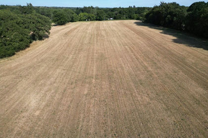
- Price
- Guide Price£200,000
- Size
- 5.91 acres
Lot 1 - Tupps Field, Passfield Road, GU30, Bramshott and Liphook, Hampshire GU30 England
Added on 17/07/2026Agricultural Land- Price
- Guide Price£200,000
- Size
- 5.91 acres
Lot 1 - Tupps Field, Passfield Road, GU30, Bramshott and Liphook, Hampshire GU30 England
Added on 17/07/2026Pasture