LOT 2 - Hawkley Road, GU33
- Land size
- 5.97 acres
Key Features
- SEE AND PRINT PDF SALES PARTICULARS AVAILABLE BELOW
- SEE DRONE VIDEO FOOTAGE ON THE VIRTUAL TOUR TAB
- APPROX. 5.97 ACRES OF ATTRACTIVE LEVEL PASTURELAND
- AVAILABLE AS A WHOLE, OR IN TWO LOTS
- EACH LOT BENEFITTING SEPARATE DIRECT ACCESS AND ROAD FRONTAGE
- ADJOINING RESIDENTIAL EDGE OF HAWKLEY VILLAGE
- WITHIN THE SOUTH DOWNS NATIONAL PARK
- GOOD TRANSPORT LINKS NEARBY
- WELL SUITED TO AGRICULTURAL, EQUESTRIAN, GRAZING, AMENITY, CONSERVATION OR RECREATIONAL USES, SUBJECT TO NECESSARY PLANNING
Description
Attractive level pastureland, extending to approximately 5.97 acres (2.42 ha), situated on the edge of the village of Hawkley within the South Downs National Park. Available as a Whole, or in Two Lots, each benefitting from separate direct access from Hawkley Road.
LOCATION: See Location Plan. The property is situated on the eastern edge of the attractive village of Hawkley, within the South Downs National Park, with frontage onto Hawkley Road and Pococks Lane. The land lies immediately adjoining the residential edge of the village and enjoys an attractive semi-rural setting within the parish of Hawkley. The property is conveniently positioned approximately 2.5 miles by road from the A3 junction with the B3006, providing good accessibility to Petersfield, Guildford and the wider Southeast.
What3Words:
Northern Access (Lot 1): Listed.years.basics;
Southern Access (Lot 2): helpfully.sunbeam.stand
DIRECTIONS: From Hawkley village centre, proceed east along Pococks Lane. The land will be found on the left-hand side and also fronts Hawkley Road to the east. The property benefits from two separate gated access points from Hawkley Road, positioned at the northern and southern ends of the holding, as identified by arrows on the Site Plan. Please refer to the Location Plan and What3Words referenced above.
DESCRIPTION: The property comprises an attractive and accessible block of permanent pasture, extending to approximately 12.19 acres (4.93 hectares) in total, positioned on the edge of the sought-after South Downs village of Hawkley. The land is generally level and has historically been used for grazing and hay production. The holding is well suited to agricultural, equestrian, grazing, amenity, conservation and recreational uses, subject to any necessary consents. The property benefits from mains water connected to a trough positioned approximately at the point marked "T" on the Site Plan. The land is offered for sale as a Whole or in Two Lots, as shown on the Site Plan. Each proposed Lot benefits from its own independent roadside access from Hawkley Road, providing flexibility for purchasers and practical day-to-day management. A particularly attractive feature is the village pond situated immediately to the north of the property, complete with seating area overlooking the pond; although the pond itself is not included within the sale.
THE LAND: The land comprises a broadly level parcel of pasture. The pasture is considered suitable for grazing, mowing and general agricultural or equestrian use. The Agricultural Land Classification identifies the land as predominantly Grade 3 agricultural land, comprising freely draining slightly acid loamy soils.
LOTTING: The property is available as a Whole or in two Lots as identified on the Site Plan.
LOT 1 - Approx. 6.22 acres (2.52 ha) of level pastureland with mains water connected and direct roadside access from Hawkley Road (northern access).
LOT 2 - Approx. 5.97 acres (2.42 ha) of level pastureland with separate roadside access from Hawkley Road (southern access).
FENCING - IF SOLD IN LOTS: If the property is sold in two Lots, the Purchaser of Lot 1 will be responsible at their own cost for erecting and thereafter maintaining a stock-proof fence along the new internal boundary separating Lots 1 and 2, within 3 months of completion.
ACCESS & RIGHTS OF WAY: The property benefits from two separate direct access points from Hawkley Road, one situated at the northern end of the property and the other at the southern end, as shown by arrows on the Site Plan. There are no public rights of way crossing the property.
PLANNING: The property lies within the South Downs National Park and falls outside defined settlement boundaries, where countryside planning policies apply. The land may offer longer-term strategic or amenity appeal, due to its position adjoining the village edge, however, purchasers must rely upon their own enquiries in relation to any future planning prospects. The Selling Agents are not aware of any recent planning applications relating to the property.
SERVICES: Mains water is connected to the land. A water trough is situated at the approximate position marked "T" on the Site Plan. No mains electricity is connected.
DESIGNATIONS:
Within the South Downs National Park
Within the Wealden Greensand National Character Area
Adjoins the Hawkley Upper Green Conservation Area to the north
Within Habitat Regulations Assessment Buffer SD10: Wealden Heaths Phase II SPA (5km buffer).
The Selling Agents are not aware of any other significant environmental designations affecting the property.
DEVELOPMENT OVERAGE: Subject to the level of any offers received, the Vendor is mindful
to retain a 25% share of any uplift in value caused by Planning Consent for any residential development on the Property for a period of 25 years.
LAND REGISTRY: The property forms the entirety of Land Registry Title No. HP568807. Copies of Title are available on Selling Agents Website.
BUSINESS RATES: Not currently demanded or assessed.
LOCAL AUTHORITY: East Hampshire District Council, Penns Place, Petersfield, Hampshire, GU31 4EX.
PLANNING AUTHORITY: South Downs National Park Authority, South Downs Centre, North Street, Midhurst, West Sussex, GU29 9DH.
OFFER INSTRUCTIONS: Please see Additional Documents on the Selling Agent's website for instructions as to how to make an offer by Private Treaty.
Map Location
Property details
- Tenure
- Freehold
- Council Tax Band
- Ask Agent
- Date Posted
- 2026-05-15
Market Value Analysis
Based on land listings in South East England (5+ acres).
Utilities & Restrictions
Utilities
- Electricity
- Ask Agent
- Water
- Ask Agent
- Heating
- Ask Agent
- Broadband
- Ask Agent
- Sewerage
- Ask Agent
Rights & Restrictions
- Public Rights of Way
- Ask Agent
- Private Rights of Way
- Ask Agent
- Listed Property
- Ask Agent
- Restrictions
- Ask Agent
Property Features
- Accessibility
- Ask Agent
- Parking
- Ask Agent
- Garden
- Ask Agent
Important notice: Information, maps and tags on this page are supplied by the advertising agent or generated automatically. LandSale has not verified them. Relying on these details is at your own risk, always carry out independent checks before committing to a purchase.
LandSale full disclaimer
Marketing information only - not formal particulars. The details on this website are provided for general guidance and do not constitute an offer or contract. Neither LandSale nor the advertising estate/land agent accepts responsibility for any inaccuracy.
1. Source of information
- Agent-supplied content: Core description, asking price, tenure, measurements, photographs and planning history are uploaded by the appointed agent, who remains solely responsible for their accuracy.
- Automated tags & categorisation: Property type, land-use class, acreage bands and similar labels may be applied by machine-learning models. They are intended as a helpful guide only and may not reflect the property's legal status or permitted use.
- Third-party & enriched data layers: Maps, boundary outlines, planning designations, soil reports, broadband coverage and other environmental or location-based insights are licensed from external suppliers. Such data are supplied “as is", may be incomplete or out of date and are subject to change without notice.
2. Verification required
Prospective purchasers must verify critical matters, including but not limited to planning permission, title boundaries, public rights of way, environmental constraints, acreage, services, access and VAT status, through their own inspections, specialist surveys, legal advisers and the selling agent before relying on the information or entering into any contract.
3. No warranty or liability
LandSale gives no warranty, express or implied, as to the accuracy, completeness or fitness for any particular purpose of the information displayed. LandSale shall not be liable for any loss, damage, cost or expense arising directly or indirectly from any use of or reliance on such information, save where liability may not be excluded by law.
4. Updates & feedback
If you believe any detail on this listing is inaccurate, please let us know. We will investigate and, where appropriate, update the listing or notify the agent.
© LandSale | Version 1.2 - January 2026
Listing agent
Giles Wheeler-Bennett, Southampton
West Court, Lower Basingwell Street, Bishop's Waltham, SO32 1AJ
Contact Giles Wheeler-Bennett, Southampton
West Court, Lower Basingwell Street, Bishop's Waltham, SO32 1AJ
View agent profileSimilar properties for sale

- Price
- Guide Price£255,000
- Size
- 6.22 acres
LOT 1 - Hawkley Road, GU33, Hawkley, Hampshire GU33 6NQ England
Added on 15/05/2026Grazing Land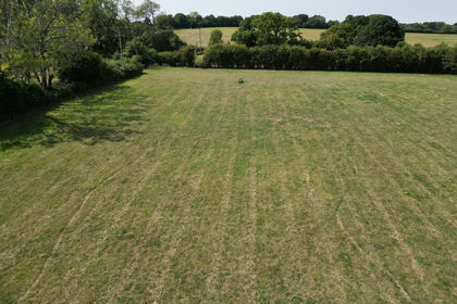
- Price
- Guide Price£290,000
- Size
- 9.75 acres
Stoner Hill Road, GU32 1DX, Froxfield and Privett, Hampshire GU32 1DZ England
Added on 29/01/2026Pasture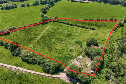
- Price
- Offers in Region of£225,000
- Size
- 6.9 acres
Willow Lodge Farm, Nyewood Road, Nyewood, South Harting, GU31, Harting, West Sussex GU31 5JB England
Added on 27/06/2026Pasture
- Price
- Guide Price£225,000
- Size
- 6.44 acres
Added on 04/06/2026Grazing Land
- Price
- Guide Price£250,000
- Size
- 5.23 acres
LOT 4 - Furzeley Road, Waterlooville, Hampshire, PO7, Denmead, Hampshire PO7 6TX England
Added on 29/01/2026Pasture
- Price
- Guide Price£290,000
- Size
- 13.42 acres
Land at Popes Lane, Upham, SO32 1JB, Fair Oak and Horton Heath, Hampshire SO32 1HH England
Added on 13/05/2026Grazing Land
- Price
- Guide Price£290,000
- Size
- 3.25 acres
"Woodmans Meadow", Winchester Road, Lower Upham, SO32 1HB, Upham, Hampshire SO32 1QN England
Added on 20/05/2026Equestrian property
- Price
- Guide Price£275,000
- Size
- 8.16 acres
Calcot Paddocks, Calcot Lane, SO32 2BN, Curdridge, Hampshire SO32 2BN England
Added on 11/04/2026Equestrian property
- Price
- Guide Price£225,000
- Size
- 10.46 acres
Added on 29/01/2026Grazing Land
- Price
- Offers in Excess of£200,000
- Size
- 6.01 acres
Meonmarsh, Bridge Street, Fareham, Hampshire, PO14, Hamble Valley, Hampshire PO14 3ET England
Added on 29/01/2026Wetland