Itchen Water Meadows, Kiln Lane, Otterbourne, Brambridge, Hampshire, SO50 6HT - PRICE GUIDE: £225, 000 - £250, 000
- Land size
- 10.46 acres
Key Features
- 10.46 ACRES OF TRADITIONAL WATER MEADOWS ADJACENT TO THE RIVER ITCHEN AND NAVIGATION
- UNIQUELY POSITIONED WITH A HIGH LEVEL OF ENVIRONMENTAL AND ECOLOGICAL HABITAT
- SUITABLE FOR RE-WILDING, BIO-DIVERSITY OFFSETTING
- AND CONVENTIONAL LIVESTOCK GRAZING
- FOR SALE BY PRIVATE TREATY AS A WHOLE AND IN ONE LOT
- PRICE GUIDE: £225,000 - £250,000
Description
"ITCHEN WATER MEADOWS"
KILN LANE, OTTERBOURNE, BRAMBRIDGE, HAMPSHIRE, SO50 6HT
Approx. distances by road: Otterbourne 1 mile, Winchester/M3 6 miles, Chandler's Ford/M3 2 miles, Eastleigh 4 miles, Southampton 8 miles, Bishops Waltham 7 miles
Location: See attached Location Plan
The Itchen Water Meadows at Brambridge are located within easy reach of Winchester 6 miles and Southampton 8 miles. The land is very well situated to take full advantage of good road and rail communications with Juction 12 of the M3 located just 1.5 miles the west of the property and mainline train services to London Waterloo from Shawford, 3 miles to the north in just 70 minutes. Southampton Airport and Parkway Railway Station are also well placed being about 4.5 miles to the south.
Directions:
From Brambridge Garden Centre, turn left out of the car park, following the lane over two bridges over The River Itchen and the entrance to Itchen Water Meadows will be found on the left hand side just before the Railway bridge.
What3Words/// matter.mock.undulation
Access: See Sale Plan over
Access to the land is through a very secure double steel gated entrance shared with Southern Water and the Portsmouth Services Fly Fishing Association. On walking down to the 10.46 acres or driving your vehicle, you proceed south, over the established access track for about 200m and then enter the northern end of the land over the Otterbourne Stream culvert, one of the main tributary carriers to the River.
General Description:
The land and its traditional ancient ridge and furrow water meadows is enclosed within a perimeter fence on the western boundary adjacent to the Railway, the eastern boundary onto the bank of the Itchen Navigation and the northeastern boundary onto one of the main tributary carrier streams leading from Otterbourne Manor to the west.
The Itchen Navigation was constructed in the late 17th Century to allow the transport of cargo on barges between Winchester and Southampton; it was also economically important for irrigating the extensive water meadows system along the valley floor, the remnants of which are still evident in this property; locks, sluices and hatches were built to control the water levels and manage flow to the water meadows and nearby mills. The Itchen Navigation was used until 1869 when the London to Southampton Railway was opened and which now forms the western boundary of the property being offered for sale.
The land is currently divided into four stock-fenced enclosures with several (unapproved) field shelters suitable for seasonal livestock grazing and animal husbandry.
All the land is designated as part of the Itchen River Site of Special Scientific Interest (SSSI) and adjoins the Itchen Special Area of Conservation (SAC). The original tow path for the Navigation is on the opposite side of the water over which "The Itchen Way" now passes. There is no general public access through any part of the property being offered for sale.
The fishing rights on the River are currently rented by The Portsmouth Services Fly Fishing Association and the riverside banks are maintained by them, leaving about a 1m width of wild bank-side vegetation and then a width of mown grass for easy access. The fishing rights are not included in the sale as they are privately owned.
The Wildlife, Fauna and Flora:
Itchen Water Meadows provides an excellent riverside habitat and has remained largely unchanged for many decades. There are water vole families in residence along the River's edge and otters are regular visitors; swans and geese nest close to the Navigation and are joined by migrating duck, coots and grebes and other overwintering birds. There is at least one family of kingfishers nesting nearby. The wetland area of the water meadows provides a quality breeding area for the rare Southern Damselfly, mayflies, stoneflies and dragonflies as well as the increasingly rare native white-clawed crayfish.
The Water Meadows themselves are also rich in plant life. Wild flowers including the Southern Marsh Orchid, Water Avens, Cuckoo flower, Mouse-ear Chickweed, Water Mint, Ragged Robin, Water Forget-me-knot, Common Fleabane and many more species are evident through the Water Meadow which has largely escaped intensive agricultural improvement or drainage.
Potential Uses:
This land has been used for many years for light agricultural grazing and farming but is equally well suited for conservation, biodiversity, seasonal livestock and equestrian grazing, and many other uses, some of which may be subject to planning environmental consents. Portable/mobile field shelters have long been installed on the land and these do provide shelter and security for any livestock.
Planning:
The land lies within the Winchester City Council and their Local Plan Policies apply. The land lies outside any recognised settlement boundary and is considered to be in the "Countryside".
Current planning regulations permit the use of land for up to 28 days in any calendar year for any purpose including camping and many other recreational uses.
This exceptionally pleasant rural river and waterside property with such a wide range of attractive characteristics and high amenity and historic conservation and environmental value, should appeal to a wide range of aspiring property owners.
Title:
The property is registered with HM Land Registry under Title No. HP751121.
Method of Sale:
The land is offered for sale freehold and by private treaty as a whole in one lot only. Prospective purchasers should register their interest with the selling agents to whom offers should be made. The land is registered so a quick sale could easily be agreed.
Safety Note:
Please ensure care is taken when viewing and walking near to the River Itchen and Navigation and through the Water Meadows. DO NOT walk close to the waterways and ensure children and any animals are supervised at all times. The River and Navigation can be dangerous, so think "SAFETY FIRST".
Local Authority:
Hampshire County Council
Winchester City Council
Agents Notes:
Rights of Way and Easements.
The property is sold subject to and with the benefit of all existing rights of way, whether public or private, light, support, drainage, water and electricity supplied and other rights, obligations, easements, quasi easements and restrictive covenants or all existing proposed and wayleaves for masts, staves, cables, drains, water and gas and other pipes whether referred to in these particulars or not.
Viewing:
Viewing is strictly through appointment with Ian Judd & Partners LLP, Tim Gardner
ANTI MONEY LAUNDERING COMPLIANCE
In accordance with the Money Laundering, Terrorist Financing and Transfer of Funds (Information on the Payer) Regulations 2017, the Selling Agents are required to undertake due diligence on property purchasers. Once an offer has been accepted, the prospective purchaser(s) will need to provide, as a minimum, proof of identify and residence, proof of source of funds for the purchase, and complete a purchasers' questionnaire before the transaction can proceed.
IMPORTANT NOTICE: Ian Judd and Partners LLP and their Clients give notice that:
1.They are not authorised to make or give any representations or warranties in relation to the property either here or elsewhere, either on their own behalf or on behalf of their client or otherwise. They assume no responsibility for any statement that may be made in these particulars. These particulars do not form part of any offer or contract and must not be relied upon as statements or representations of fact.
2. Any areas, measurements or distances are approximate. The text, photographs and plans are for guidance only and are not necessarily comprehensive. It should not be assumed that the property has all necessary planning, building regulation or other consents and Ian Judd and Partners have not tested any services, equipment or facilities. Purchasers must satisfy themselves by inspection or otherwise.
3. The reference to any mechanical or electrical equipment or other facilities at the property shall not constitute a representation (unless otherwise stated) as to its state or condition or that it is capable of fulfilling its intended function and prospective purchasers/tenants should satisfy themselves as to the fitness of such equipment for their requirements. We have not made any investigations into the existence or otherwise of any issues concerning pollution of land, air or water contamination and the purchaser is responsible for making his own enquiries in this regard.
4. Tax may be payable in addition to the purchase price of any property according to law. Ian Judd and Partners is a Limited Liability Partnership.
December 2025
Map Location
Property details
- Tenure
- Freehold
- Council Tax Band
- Ask Agent
- Date Posted
- 2026-01-29
Market Value Analysis
Compared with 63 Farmland & Pasture listings in South East England (10+ acres).
Utilities & Restrictions
Utilities
- Electricity
- Ask Agent
- Water
- Ask Agent
- Heating
- Ask Agent
- Broadband
- Ask Agent
- Sewerage
- Ask Agent
Rights & Restrictions
- Public Rights of Way
- Ask Agent
- Private Rights of Way
- Ask Agent
- Listed Property
- Ask Agent
- Restrictions
- Ask Agent
Listed status, conservation areas and planning constraints for this location are in the full report.
Property Features
- Accessibility
- Ask Agent
- Parking
- Parking Available
- Garden
- Garden
Beyond the particulars: planning activity, flood history, heritage and ground risks, checked for this exact spot.
Connectivity
Broadband
Fastest speed available at this postcode
80 Mbps
Superfast
Suitable for
- HD streaming
- Video calls
- Web & social
Mobile signal
Predicted 4G and 5G signal; indoor signal depends on building materials.
Ofcom Connected Nations postcode-level predictions. Speeds and signal are modelled, not measured, and vary between addresses and providers.
Signal is the easy part. Planning activity, flood history and protected designations here are in the full report.
Nearest Schools
Primary
- Otterbourne Church of England Primary School0.7 milesOfsted: Good *
- Ages
- 4 to 11
- Pupils
- 269
- Type
- Voluntary controlled school
- Faith
- Church of England
- Colden Common Primary School0.7 milesNo Ofsted rating
- Ages
- 4 to 11
- Pupils
- 403
- Type
- Community school
- Twyford St Mary's Church of England Primary School1.5 milesNo Ofsted rating
- Ages
- 4 to 11
- Pupils
- 141
- Type
- Voluntary controlled school
- Faith
- Church of England
- Scantabout Primary School1.5 milesNo Ofsted rating
- Ages
- 4 to 11
- Pupils
- 216
- Type
- Community school
- Shakespeare Junior School1.7 milesOfsted report card · Jan 2026
- Ages
- 7 to 11
- Pupils
- 334
- Type
- Community school
Secondary
- Thornden School1.2 milesOfsted report card · Jun 2026
- Ages
- 11 to 16
- Pupils
- 1,440
- Type
- Academy converter
- Crestwood Community School1.8 milesNo Ofsted rating
- Ages
- 11 to 16
- Pupils
- 1,478
- Type
- Community school
- The Toynbee School2.2 milesNo Ofsted rating
- Ages
- 11 to 16
- Pupils
- 1,107
- Type
- Community school
- Wyvern College3.2 milesNo Ofsted rating
- Ages
- 11 to 16
- Pupils
- 1,313
- Type
- Academy converter
- Kings' School4.1 milesOfsted: Good
- Ages
- 11 to 16
- Pupils
- 1,737
- Type
- Community school
* Latest graded judgement covers quality of education only; no overall grade was issued under the 2024-25 inspection framework.
Distances are straight-line from the advertised location. Source: the national school registers (DfE, Welsh Government, Scottish Government) and Ofsted.
Schools are just the start: sold prices nearby, planning activity and any flood history are in the full report.
Amenities
Supermarket
GP surgery
Pharmacy
Hospital
Green space
Straight-line distances from the advertised location. Sources: NHS records, Geolytix supermarket locations, OS Open Greenspace and the national trails registers.
The area stacks up? Now check the location itself: planning nearby, protected designations and past flooding.
Getting Around
Nearest station
Nearest bus stop
Typical drive times
Straight-line distances from the advertised location; drive times are typical free-flow times over OpenStreetMap road data, so allow more at peak. Public transport locations from DfT NaPTAN.
Easy to reach matters. So do planning activity, flood history and ground risks: all in the full report.
Flood Risk
Environment Agency open data, checked around the advertised map pin for the listed acreage. Long-term risk counts flood defences; the planning map's flood zones do not. Provided by LandSale, not the listing agent, and not part of the agent's particulars. Risk varies across a holding, so verify before committing.
Rivers and the sea
Planning map: Flood Zone 3.
Surface water
Not at the pin: mapped about 40 metres away.
These bandings are the summary. Where this location sits on the flood maps, plus planning activity, heritage and ground risks, is in the full report.
Important notice: Information, maps and tags on this page are drawn from the advertising agent's marketing materials or generated automatically. LandSale has not verified them. Relying on these details is at your own risk, always carry out independent checks before committing to a purchase.
LandSale full disclaimer
Marketing information only - not formal particulars. The details on this website are provided for general guidance and do not constitute an offer or contract. Neither LandSale nor the advertising estate/land agent accepts responsibility for any inaccuracy.
1. Source of information
- Listing content: Core description, asking price, tenure, measurements, photographs and planning history originate from the marketing materials of the advertising estate or land agent. LandSale does not author this content and cannot guarantee its accuracy.
- Automated tags & categorisation: Property type, land-use class, acreage bands and similar labels may be applied by machine-learning models. They are intended as a helpful guide only and may not reflect the property's legal status or permitted use.
- Third-party & enriched data layers: Maps, boundary outlines, planning designations, soil reports, broadband coverage and other environmental or location-based insights are licensed from external suppliers. Such data are supplied “as is", may be incomplete or out of date and are subject to change without notice.
2. Verification required
Prospective purchasers must verify critical matters, including but not limited to planning permission, title boundaries, public rights of way, environmental constraints, acreage, services, access and VAT status, through their own inspections, specialist surveys, legal advisers and the selling agent before relying on the information or entering into any contract.
3. No warranty or liability
LandSale gives no warranty, express or implied, as to the accuracy, completeness or fitness for any particular purpose of the information displayed. LandSale shall not be liable for any loss, damage, cost or expense arising directly or indirectly from any use of or reliance on such information, save where liability may not be excluded by law.
4. Updates & feedback
If you believe any detail on this listing is inaccurate, please let us know. We will investigate and, where appropriate, update the listing or notify the agent.
© LandSale | Version 1.3 - August 2026
Listing agent
Ian Judd & Partners, Bishops Waltham
4 High Street, Bishops Waltham, Southampton, SO32 1AB
Contact Ian Judd & Partners, Bishops Waltham
4 High Street, Bishops Waltham, Southampton, SO32 1AB
View agent profileSimilar properties for sale
- Price
- Guide Price£250,000
- Size
- 11.12 acres
Land at Mare Lane, Owslebury, Winchester, SO21, Owslebury, Hampshire SO21 England
Added on 01/10/2026Agricultural Land
- Price
- Guide Price£200,000
- Size
- 7.99 acres
Added on 27/08/2026Farmland
- Price
- Offers in Excess of£200,000
- Size
- 6.01 acres
Meonmarsh, Bridge Street, Fareham, Hampshire, PO14, Hamble Valley, Hampshire PO14 England
Added on 29/01/2026Wetland
- Price
- Guide Price£255,000
- Size
- 6.22 acres
Added on 15/05/2026Grazing Land
- Price
- Guide Price£240,000
- Size
- 5.97 acres
Added on 15/05/2026Pasture
- Price
- Offers in Region of£225,000
- Size
- 6.9 acres
Willow Lodge Farm, Nyewood Road, Nyewood, South Harting, GU31, Harting, West Sussex GU31 England
Added on 27/06/2026Pasture
- Price
- Guide Price£220,000
- Size
- 16.5 acres
Havenstreet, Isle of Wight, Havenstreet and Ashey, Isle of Wight PO33 England
Added on 29/01/2026Farmland
- Price
- Guide Price£230,000
- Size
- 9.7 acres
Wellow, Isle of Wight, Shalfleet, Isle of Wight PO41 England
Added on 25/03/2026Grazing Land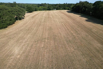
- Price
- Guide Price£200,000
- Size
- 5.91 acres
Lot 1 - Tupps Field, Passfield Road, GU30, Bramshott and Liphook, Hampshire GU30 England
Added on 17/07/2026Agricultural Land- Price
- Guide Price£200,000
- Size
- 5.91 acres
Lot 1 - Tupps Field, Passfield Road, GU30, Bramshott and Liphook, Hampshire GU30 England
Added on 17/07/2026Pasture