Meonmarsh, Bridge Street, Fareham, Hampshire, PO14
- Land size
- 6.01 acres
Key Features
- SEE AND PRINT PDF SALES PARTICULARS AVAILABLE BELOW
- SEE DRONE VIDEO FOOTAGE ON THE VIRTUAL TOUR TAB
- APPROX. 6.01 ACRES
- WATER MEADOWS ON THE EASTERN BANKS OF THE RIVER MEON
- VIEWING STRICTLY BY PRIOR APPOINTMENT AND TO BE ACCOMPANIED. BRING WELLINGTONS OR THIGH WADERS.
- WITHIN 2KM OF THE SOLENT
- POTENTIAL NITRATE MITIGATION WETLAND SCHEME
- ATTRACTING WILDFOWL AND OTHER BIRD SPECIES
- FISHING RIGHTS
- SEASONALLY UNDER WATER
Description
VIEWING INSTRUCTIONS: STRICTLY BY APPOINTMENT ONLY AND TO BE ACCOMPANIED. WELLINGTON BOOTS OR THIGH WADERS ARE ESSENTIAL. It is essential to view the drone video footage available prior to booking at viewing at the Property.
BOOKING IN ADVANCE IS ESSENTIAL. Please contact Giles Wheeler-Bennett Ltd.
VIDEO DRONE FOOTAGE: See the Selling Agent's website further details, photographs and drone video footage is available showing the whole Property.
LOCATION: See Location Plan. The Property benefits from a Right of Way through a vehicular gate off the south side of Bridge Street where the Property is identified by the red arrow. Postcode PO14 3ES. What3Words: Access Gate: PARKING - VIEWINGS: There is a Public Car Park off Bridge Street approx. 200m to the west of the access gate. Public Car Park: The Property extends to approx. 6.01 acres (2.43 Ha) bare water meadows land on the eastern bank of the River Meon. The water meadows are comprised of marshy grassland, up to two thirds of which floods seasonally (Flood Zone 3). The parcel is located on the lower floodplain of the river Meon. Much of the land is typically under water for the winter months.
LAND REGISTRY: The Property comprises the entirety of Land Registry Title HP844188. See Plan and Register on Selling Agent's website.
RIGHT OF WAY: The Property benefits from a right of way across neighbouring pasture land 'at all times and for all purposes with or without vehicles' over a strip 3m in width between positions A and B and shaded brown on the Site Plan.
PROPERTY BOUNDARIES: Inside the northern boundary there is a post and wire fence between positions B and E on the Site Plan.
The drainage channel along the eastern boundary forms part of the Property (see Title Plan).
The drainage channel immediately to the north of the post and wire fence between B and E forms part of the Property (see Title Plan).
RIVER MEON: The Property has approx. 300m of direct frontage along the river which is an important chalk stream valued for its wildlife.
FISHING RIGHTS: A previous owner has reserved the right to fish along approx. 70m of the bank along the River Meon between positions B and F on the Site Plan. Access on foot only across 2m of the river bank adjoining the river. This detailed in the Transfer dated 21st February 2020 available on the Selling Agent's website. All other Fishing Rights are in-hand and available to a Purchaser.
SPORTING RIGHTS: No other party holds these rights across any part of the Property. They are in-hand.
NITRATE MITIGATION SCHEME: The Property achieved Planning Consent for a Wetland system for Nitrate Mitigation in 2022 (P/20/1353/FP - 27th July 2022). Effectively this was to utilise the seasonal breach of the river at point C on the Site Plan which flows and cuts the corner of the bend around the western perimeter of the land, and then re-enters the river at the southern end at point D on the Site Plan. The proposed scheme was for the establishment of a Reed bed habitat across part of the land which would have the effect of extracting Nitrates from the water prior to it returning to main river and entering The Solent downstream. See the Proposed Surface Flow Wetland Layout Plan on the Selling Agent's website.
Predicted Nitrate Reduction from a scheme has been estimated in the order of 1,765kg per annum. There will be additional units caused by taking the land out of agricultural production.
The Vendors were unable to implement the scheme (for various reasons of their own) and so that Consent will expire in July 2025. There is the opportunity for a Purchaser to re-apply utilising much of the existing application material when a new 3-year period will be achieved.
If any party is interested in reviewing the documents that formed part of the Planning Application process then visit Fareham Borough Council Planning Portal. Planning Ref: P/20/1353/FP.
If you contact the Selling Agent they can send you much documentation on the Nitrate Mitigation Scheme to consider electronically.
BIODIVERSITY NET GAIN (BNG): If a Wetland Nitrate Mitigation is implemented, it is understood that 3.96 biodiversity units will be produced.
WAYLEAVES AND EASEMENTS: A Southern Water sewer passes through the Property. See Plan available on Selling Agent's website. Overhead Electricity wires (2 x 33kv) cross the northern section of the Property.
NITRATE MITIGATION OVERAGE: The Vendors are mindful to reserve the right to receive a percentage of any future income, subject to negotiation, if a Wetland Nitrate Mitigation Scheme is implemented on the Property within 10 years.
OPTION: The Vendors are not interested to enter any Option on the Property (e.g. for renewal of the previous Wetland Nitrate Mitigation). They are only interested to sell the freehold property.
SERVICES: None connected.
LOCAL AUTHORITY: Fareham Borough Council, Civic Offices, Civic Way, Hampshire PO16 7AZ.
Map Location
Property details
- Tenure
- Freehold
- Council Tax Band
- Ask Agent
- Date Posted
- 2026-01-29
Market Value Analysis
Compared with 183 land-only listings in South East England (5+ acres).
Utilities & Restrictions
Utilities
- Electricity
- Ask Agent
- Water
- Ask Agent
- Heating
- Ask Agent
- Broadband
- Ask Agent
- Sewerage
- Ask Agent
Rights & Restrictions
- Public Rights of Way
- Ask Agent
- Private Rights of Way
- Ask Agent
- Listed Property
- Ask Agent
- Restrictions
- Ask Agent
Property Features
- Accessibility
- Ask Agent
- Parking
- Parking Available
- Garden
- Ask Agent
Important notice: Information, maps and tags on this page are supplied by the advertising agent or generated automatically. LandSale has not verified them. Relying on these details is at your own risk, always carry out independent checks before committing to a purchase.
LandSale full disclaimer
Marketing information only - not formal particulars. The details on this website are provided for general guidance and do not constitute an offer or contract. Neither LandSale nor the advertising estate/land agent accepts responsibility for any inaccuracy.
1. Source of information
- Agent-supplied content: Core description, asking price, tenure, measurements, photographs and planning history are uploaded by the appointed agent, who remains solely responsible for their accuracy.
- Automated tags & categorisation: Property type, land-use class, acreage bands and similar labels may be applied by machine-learning models. They are intended as a helpful guide only and may not reflect the property's legal status or permitted use.
- Third-party & enriched data layers: Maps, boundary outlines, planning designations, soil reports, broadband coverage and other environmental or location-based insights are licensed from external suppliers. Such data are supplied “as is", may be incomplete or out of date and are subject to change without notice.
2. Verification required
Prospective purchasers must verify critical matters, including but not limited to planning permission, title boundaries, public rights of way, environmental constraints, acreage, services, access and VAT status, through their own inspections, specialist surveys, legal advisers and the selling agent before relying on the information or entering into any contract.
3. No warranty or liability
LandSale gives no warranty, express or implied, as to the accuracy, completeness or fitness for any particular purpose of the information displayed. LandSale shall not be liable for any loss, damage, cost or expense arising directly or indirectly from any use of or reliance on such information, save where liability may not be excluded by law.
4. Updates & feedback
If you believe any detail on this listing is inaccurate, please let us know. We will investigate and, where appropriate, update the listing or notify the agent.
© LandSale | Version 1.2 - January 2026
Listing agent
Giles Wheeler-Bennett, Southampton
West Court, Lower Basingwell Street, Bishop's Waltham, SO32 1AJ
Contact Giles Wheeler-Bennett, Southampton
West Court, Lower Basingwell Street, Bishop's Waltham, SO32 1AJ
View agent profileSimilar properties for sale

- Price
- Guide Price£250,000
- Size
- 5.23 acres
LOT 4 - Furzeley Road, Waterlooville, Hampshire, PO7, Denmead, Hampshire PO7 6TX England
Added on 29/01/2026Pasture
- Price
- Guide Price£220,000
- Size
- 16.5 acres
Havenstreet, Isle of Wight, Havenstreet and Ashey, Isle of Wight PO33 4DT England
Added on 05/06/2026Farmland- Price
- Guide Price£220,000
- Size
- 16.5 acres
Havenstreet, Isle of Wight, Havenstreet and Ashey, Isle of Wight PO33 4DT England
Added on 29/01/2026Farmland
- Price
- Guide Price£225,000
- Size
- 10.46 acres
Added on 29/01/2026Grazing Land
- Price
- Guide Price£199,950
- Size
- 7.66 acres
Calbourne, Isle Of Wight, Calbourne, Newtown and Porchfield, Isle of Wight PO30 4HZ England
Added on 18/06/2026Grazing Land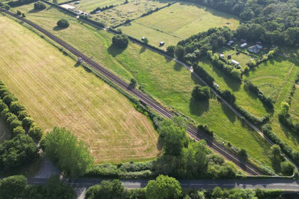
- Price
- Guide Price£230,000
- Size
- 8.08 acres
Whichers Gate Road, Rowlands Castle, PO9, Rowlands Castle, Hampshire PO9 5NE England
Added on 08/07/2026Vacant Land
- Price
- Guide Price£230,000
- Size
- 9.7 acres
Wellow, Isle of Wight, Shalfleet, Isle of Wight PO41 0SZ England
Added on 25/03/2026Grazing Land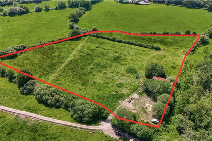
- Price
- Offers in Region of£225,000
- Size
- 6.9 acres
Willow Lodge Farm, Nyewood Road, Nyewood, South Harting, GU31, Harting, West Sussex GU31 5JB England
Added on 27/06/2026Pasture
- Price
- Guide Price£240,000
- Size
- 5.97 acres
LOT 2 - Hawkley Road, GU33, Hawkley, Hampshire GU33 6NE England
Added on 15/05/2026Pasture
- Price
- Guide Price£200,000
- Size
- 3.6 acres
Added on 26/03/2026Grazing Land