Grouse Road, Colgate, RH13
- Land size
- 1.57 acres
- Bedrooms
- 4
- Bathrooms
- 4
Key Features
- 4 double sized bedrooms
- Spacious and beautifully presented detached single storey residence
- Secluded 1.57 acre west facing plot with stunning outlook
- Large and secure gated driveway with ample parking
- Double garage and separate triple car-port with workshop and storage
- Breath-taking semi rural but convenient position close to amenities
- Newly re-fitted kitchen and 2 bath/shower rooms
- Opportunity to add an additional storey, if required and subject to planning permission
- Detached self-contained annex with kitchenette and shower room
- Newly constructed studio and stabling with opportunity to improve or convert
Description
Gide price £1,400,000 - £1,500,000
No onward chain
An exceptional and hugely versatile 4 bedroom detached single storey property which has been skilfully enlarged and tastefully renovated to a high specification with impressive principal suite, family sized kitchen/dining room and stunning vaulted siting room.
This unique residence occupies a secluded 1.57 acre west facing plot which enjoys a superb outlook towards woodland and benefits from a double garage, separate triple carport with workshop, detached annex and newly constructed studio.
This semi-rural but convenient location is within striking distance of highly regarded schools, major transport links, fantastic country walks in St. Leonards Forest and Horsham and Crawley are nearby for shopping facilities.
The accommodation comprises: entrance hallway, 20’6 × 17’10 vaulted sitting room with Inglenook fireplace and wood burner, and French doors lead onto the garden.
The 29’8 × 16’8 kitchen/dining/family room has been refitted with a beautiful selection of Wren units, Quartz work surfaces, breakfast bar that seats 4 and a bar with refrigeration is perfect for those parties. The integrated AEG appliances include 5 gas ring burner hob, remote controlled extractor, ovens, combination oven/microwave, fridge, dishwasher, and Quooker boiling tap. The dining/family section provide instant access via a set of bi-folding doors onto the decked seating area.
A door from then leads into the utility/boot room, cloakroom and onto the garden and back into the hallway.
The principal bedroom is fitted with wardrobes, dressing area and re-modelled bath/shower room.
There are 3 further double sized bedrooms (bedroom 2 and 3 with fitted storage) and re-fitted shower room.
Benefits include security entry system, double glazed windows, re-decorated, new flooring and carpeting and oil-fired central heating to radiators to the main house.
A secure and remote controlled gated entrance provides a perfect approach to a large parking area, 19’3 × 18’8 double garage with power, remote controlled roller shutter doors, courtesy door to the rear garden and full height loft storage above. There is an opportunity to incorporate this into the property which would create additional living accommodation, if required.
There is further covered parking in the 27’10 × 17’4 open carport with cabling for a EV charge point, attached workshop, sit-on mower store and log store.
The 22’2 × 17’10 detached annex with kitchenette and shower room is ideal for elderly relatives, teenagers, or those with a business.
The 1.57 acre west facing garden is a particular feature with a high degree of privacy and a beautiful outlook over neighbouring paddocks and woodland. The garden is predominately lawned with 2 well established borders, pond and stabling which provide scope to improve or convert. A recently constructed composite decked entertaining area is ideal for those family get-togethers or enjoying a sundowner.
The 16’6 × 12’5 detached studio/garden room with bi-folding doors onto a deck and store room is simply perfect for further entertaining or workspace and has the benefit of an additional attached double aspect 12’6 × 7’ gym room.
EPC Rating: D
Disclaimer
In accordance with the requirements of the Anti Money Laundering Act 2022, Mansell McTaggart Horsham Ltd. mandates that prospective purchaser(s) who have an offer accepted on one of our properties undergo identification verification. To facilitate this, we utilise MoveButler, an online platform for identity verification. The cost for each identification check is £35, including VAT charged by MoveButler at the point of onboarding, per individual (or company) listed as a purchaser in the memorandum of sale. This fee is non-refundable, regardless of the circumstances.
Map Location
Property details
- Tenure
- Freehold
- Council Tax Band
- G
- Date Posted
- 2026-01-29
Market Value Analysis
Compared with 1,861 Homes with Land listings in South East England (1+ acres).
Utilities & Restrictions
Utilities
- Electricity
- Ask Agent
- Water
- Ask Agent
- Heating
- Ask Agent
- Broadband
- Ask Agent
- Sewerage
- Ask Agent
Rights & Restrictions
- Public Rights of Way
- Ask Agent
- Private Rights of Way
- Ask Agent
- Listed Property
- Ask Agent
- Restrictions
- Ask Agent
Listed status, conservation areas and planning constraints for this location are in the full report.
Property Features
- Accessibility
- Ask Agent
- Parking
- Parking Available
- Garden
- Garden
Beyond the particulars: planning activity, flood history, heritage and ground risks, checked for this exact spot.
Connectivity
Broadband
Fastest speed available at this postcode
1.8 Gbps
Gigabit full fibre · available to 91% of premises
Suitable for
- 4K streaming on every screen
- Full-time home working
- Online gaming & big downloads
Mobile signal
Outdoor predictions; indoor signal depends on building materials.
Ofcom Connected Nations postcode-level predictions. Speeds and signal are modelled, not measured, and vary between addresses and providers.
Signal is the easy part. Planning activity, flood history and protected designations here are in the full report.
Nearest Schools
Primary
- Colgate Primary School0.7 milesNo Ofsted rating
- Ages
- 4 to 11
- Pupils
- 126
- Type
- Community school
- Handcross Primary School1.6 milesNo Ofsted rating
- Ages
- 2 to 11
- Pupils
- 238
- Type
- Community school
- Woodgate Primary Academy1.7 milesOfsted report card · Apr 2026
- Ages
- 2 to 11
- Pupils
- 169
- Type
- Academy converter
- Kilnwood Vale Primary School1.9 milesOfsted: Good
- Ages
- 2 to 11
- Pupils
- 382
- Type
- Free schools
- Seymour Primary School2 milesNo Ofsted rating
- Ages
- 3 to 11
- Pupils
- 455
- Type
- Academy converter
Secondary
- Holy Trinity CofE Secondary School, Crawley2.3 milesOfsted: Good
- Ages
- 11 to 18
- Pupils
- 1,340
- Type
- Voluntary aided school
- Faith
- Church of England
- Thomas Bennett Community College2.4 milesOfsted: Good
- Ages
- 11 to 18
- Pupils
- 1,261
- Type
- Academy converter
- St Wilfrid's Catholic Comprehensive School, Crawley2.7 milesNo Ofsted rating
- Ages
- 11 to 18
- Pupils
- 1,174
- Type
- Voluntary aided school
- Faith
- Roman Catholic
- Ifield Community College3.1 milesNo Ofsted rating
- Ages
- 11 to 18
- Pupils
- 1,214
- Type
- Academy converter
- Bohunt Horsham3.2 milesOfsted: Good
- Ages
- 4 to 16
- Pupils
- 1,294
- Type
- Free schools
Distances are straight-line from the advertised location. Source: the national school registers (DfE, Welsh Government, Scottish Government) and Ofsted.
Schools are just the start: sold prices nearby, planning activity and any flood history are in the full report.
Amenities
Supermarket
GP surgery
Pharmacy
Hospital
Straight-line distances from the advertised location. Sources: NHS records, Geolytix supermarket locations, OS Open Greenspace and the national trails registers.
The area stacks up? Now check the location itself: planning nearby, protected designations and past flooding.
Getting Around
Nearest station
Nearest bus stop
Typical drive times
Straight-line distances from the advertised location; drive times are typical free-flow times over OpenStreetMap road data, so allow more at peak. Public transport locations from DfT NaPTAN.
Easy to reach matters. So do planning activity, flood history and ground risks: all in the full report.
Flood Risk
From Environment Agency flood map open data, checked around the advertised map pin and allowing for the listed acreage where known. This summary comes from LandSale, the advertising platform, not from the listing agent, and is not part of the agent's particulars. Risk can vary across a single holding, so verify anything critical through your own searches before committing.
Rivers and the sea
Surface water
The detail behind these bandings
The full report pinpoints where this location sits on the flood maps, and runs the deeper checks that usually only surface after an offer.
- Exact flood zones & annual chances (included in the full report)
- Any recorded past flooding (included in the full report)
- Planning activity nearby (included in the full report)
- Heritage & conservation (included in the full report)
- Protected nature designations (included in the full report)
- Ground risks (included in the full report)
- Sold prices nearby (included in the full report)
£14.99 · one-off purchase
By LandSale, the platform. Not provided by the listing agent. Ready in about a minute.
Important notice: Information, maps and tags on this page are drawn from the advertising agent's marketing materials or generated automatically. LandSale has not verified them. Relying on these details is at your own risk, always carry out independent checks before committing to a purchase.
LandSale full disclaimer
Marketing information only - not formal particulars. The details on this website are provided for general guidance and do not constitute an offer or contract. Neither LandSale nor the advertising estate/land agent accepts responsibility for any inaccuracy.
1. Source of information
- Listing content: Core description, asking price, tenure, measurements, photographs and planning history originate from the marketing materials of the advertising estate or land agent. LandSale does not author this content and cannot guarantee its accuracy.
- Automated tags & categorisation: Property type, land-use class, acreage bands and similar labels may be applied by machine-learning models. They are intended as a helpful guide only and may not reflect the property's legal status or permitted use.
- Third-party & enriched data layers: Maps, boundary outlines, planning designations, soil reports, broadband coverage and other environmental or location-based insights are licensed from external suppliers. Such data are supplied “as is", may be incomplete or out of date and are subject to change without notice.
2. Verification required
Prospective purchasers must verify critical matters, including but not limited to planning permission, title boundaries, public rights of way, environmental constraints, acreage, services, access and VAT status, through their own inspections, specialist surveys, legal advisers and the selling agent before relying on the information or entering into any contract.
3. No warranty or liability
LandSale gives no warranty, express or implied, as to the accuracy, completeness or fitness for any particular purpose of the information displayed. LandSale shall not be liable for any loss, damage, cost or expense arising directly or indirectly from any use of or reliance on such information, save where liability may not be excluded by law.
4. Updates & feedback
If you believe any detail on this listing is inaccurate, please let us know. We will investigate and, where appropriate, update the listing or notify the agent.
© LandSale | Version 1.3 - August 2026
Listing agent
Mansell McTaggart, Horsham
26 Carfax, Horsham, RH12 1EE
Similar properties for sale
- Price
- £1,250,000
- Size
- 3 acres
South Lodge, Buchan Hill, Pease Pottage, Crawley, Slaugham, West Sussex RH11 England
Added on 01/05/2026House with Land
- Price
- Offers Over£1,750,000
- Size
- 3.25 acres
Added on 25/04/2026Country Home
- Price
- £1,500,000
- Size
- 1 acres
Handcross Road, Plummers Plain, Lower Beeding, West Sussex RH13 England
Added on 12/07/2026Country Home
- Price
- Guide Price£1,600,000
- Size
- 9.6 acres
Redbridge Lane, Balcombe, Balcombe, West Sussex RH17 England
Added on 05/07/2026House with Land
- Price
- Guide Price£1,425,000
- Size
- 1 acres
Church Lane, Plummers Plain, RH13, Lower Beeding, West Sussex RH13 England
Added on 28/08/2026House with Land
- Price
- Offers in Excess of£1,500,000
- Size
- 2.3 acres
Added on 29/01/2026House with Land Added on 08/08/2026Development Land
- Price
- Guide Price£1,450,000
- Size
- 1.17 acres
Newells Lane, Lower Beeding, RH13, Lower Beeding, West Sussex RH13 England
Added on 20/08/2026House with Land- Price
- Guide Price£1,650,000
- Size
- 11.64 acres
Newells Lane, Lower Beeding, RH13, Lower Beeding, West Sussex RH13 England
Added on 08/07/2026House with Land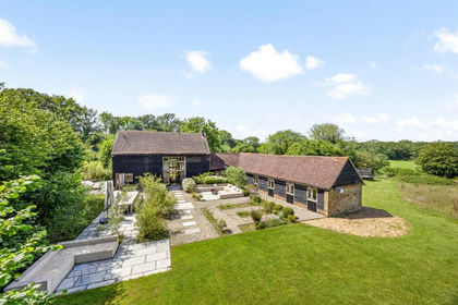
- Price
- Guide Price£1,400,000
- Size
- 3 acres
Cleavers Lane, Cuckfield, RH17, Ansty and Staplefield, West Sussex RH17 England
Added on 02/07/2026Barn Conversion