Pilton, Oundle, Peterborough, PE8
- Land size
- 2.05 acres
- Bedrooms
- 3
Key Features
- Create something amazing
- Refurbishment or Redevelopment Opportunity
- Fabulous Hillside Setting
- Far-Reaching Views
- FPP For High Specification Detached House with Studio
- 2.05 acre site
- Close to Oundle
Description
The Current Property
Coppice Lodge dates from the late Edwardian era and is constructed of local limestone beneath a Collyweston slate roof. The property is neither listed nor situated within a Conservation Area and historically served as a farm cottage for many decades.
The existing house now requires updating and offers the opportunity for refurbishment, alternatively, purchasers may wish to take advantage of the recently granted Planning Permission for a replacement dwelling.
Occupying an enviable hilltop position, the property enjoys spectacular, far-reaching rural views in all directions, with Lyveden New Bield visible to one side and the historic market town of Oundle to the other. Lawned gardens surround the house, creating a wonderful sense of space and privacy.
A gated driveway leads from Bearshanks Lane, a peaceful no-through country lane, down to the house and adjoining farmyard. A range of outbuildings includes stables, a brick machinery store, a Dutch barn and two steel portal-framed cattle barns.
In addition, there are two unfenced paddocks, with the entire property enclosed by mature hedging. The combination of its elevated setting, extensive grounds and existing buildings makes this a particularly interesting and increasingly rare opportunity.
The Opportunity
Coppice Lodge presents an exciting opportunity to create a truly individual country home in an exceptional rural setting, enjoying panoramic views, a wonderful sense of seclusion and no immediate neighbours, yet conveniently positioned just 3 miles from the highly regarded market town of Oundle.
Full Planning Permission has been granted for an architecturally distinctive replacement residence, designed in an attractive contemporary barn style.
The proposed principal dwelling extends to approximately 306 sq. m (3,294 sq. ft) and incorporates generous reception accommodation, four bedrooms and three bathrooms, including an annex.
Within the grounds, consent has also been granted for a separate yoga studio with home office, extending to approximately 94 sq. m (1,011 sq. ft) and enjoying an outlook over the pond.
The consented scheme offers considerable scope to create a high-specification home, combining contemporary living with a rural architectural aesthetic. Alternative schemes or designs may also be acceptable to the Local Planning Authority, subject to the necessary consents.
Planning Permission
Full Planning Permission was granted by North Northamptonshire Council on 11 July 2025 for the construction of a replacement dwelling under planning reference NE24/01178/FUL.
An electronic copy of the Decision Notice and approved planning drawings is available from Woodford & Co.
Location
Coppice Lodge occupies a delightful rural position on the western outskirts of the small village of Pilton, within the beautiful Nene Valley.
The property is approached via Bearshanks Lane, a peaceful no-through country lane serving just five other properties before terminating at Bearshanks Wood. The setting is wonderfully tranquil, with attractive open countryside and far-reaching views in every direction.
The historic market town of Oundle lies approximately 3 miles to the north-west and offers an excellent range of independent shops, businesses, cafés and restaurants, centred around its attractive Georgian Market Place. The town is particularly well regarded for its choice of schooling, together with an excellent range of leisure and sporting facilities.
For more extensive amenities, the larger centres of Peterborough and Wellingborough are both within convenient reach. Each offers a comprehensive range of shopping and leisure facilities, together with mainline rail connections to London, with journey times from approximately 48 minutes.
Coppice Lodge offers a rare combination of rural tranquillity, spectacular countryside views and exciting redevelopment potential, all within easy reach of the amenities and excellent schooling of Oundle.
IMPORTANT NOTE TO PURCHASERS:
We endeavour to make our sales particulars accurate and reliable, however, they do not constitute or form part of an offer or any contract and none is to be relied upon as statements of representation or fact. Any services, systems and appliances listed in this specification have not been tested by us and no guarantee as to their operating ability or efficiency is given. All measurements have been taken as a guide to prospective buyers only, and are not precise. Please be advised that some of the particulars may be awaiting vendor approval. If you require clarification or further information on any points, please contact us, especially if you are travelling some distance to view. Fixtures and fittings other than those mentioned are to be agreed with the seller.
OUN250267/
Map Location
Property details
- Tenure
- Freehold
- Council Tax Band
- E
- Date Posted
- 2026-11-06
Market Value Analysis
Compared with 131 Development Land listings in East Midlands (1+ acres).
Energy Performance Certificate
Energy Efficiency Rating
Based on UK Energy Performance Certificate standards (EU Directive 2002/91/EC)
Running costs are one side. Planning activity, flood history and ground risks for this location are in the full report.
Utilities & Restrictions
Utilities
- Electricity
- Mains
- Water
- Mains
- Heating
- Ask Agent
- Broadband
- Ask Agent
- Sewerage
- Septic Tank / Private
Rights & Restrictions
- Public Rights of Way
- Ask Agent
- Private Rights of Way
- Ask Agent
- Listed Property
- Ask Agent
- Restrictions
- Ask Agent
Listed status, conservation areas and planning constraints for this location are in the full report.
Property Features
- Accessibility
- Ask Agent
- Parking
- Parking Available
- Garden
- Garden
Beyond the particulars: planning activity, flood history, heritage and ground risks, checked for this exact spot.
Connectivity
Broadband
Fastest speed available at this postcode
1 Gbps
Gigabit full fibre
Suitable for
- 4K streaming on every screen
- Full-time home working
- Online gaming & big downloads
Mobile signal
Predicted 4G and 5G signal; indoor signal depends on building materials.
Ofcom Connected Nations postcode-level predictions. Speeds and signal are modelled, not measured, and vary between addresses and providers.
Signal is the easy part. Planning activity, flood history and protected designations here are in the full report.
Nearest Schools
Primary
- Trinity Church of England Primary School2 milesOfsted: Good
- Ages
- 4 to 11
- Pupils
- 160
- Type
- Academy converter
- Faith
- Church of England
- Oundle Church of England Primary School3.1 milesOfsted: Good
- Ages
- 3 to 11
- Pupils
- 387
- Type
- Academy converter
- Faith
- Church of England
- Titchmarsh Church of England Primary School3.4 milesOfsted report card · Jun 2026
- Ages
- 4 to 11
- Pupils
- 101
- Type
- Voluntary controlled school
- Faith
- Church of England
- Glapthorn Church of England Primary School3.4 milesNo Ofsted rating
- Ages
- 5 to 11
- Pupils
- 83
- Type
- Academy converter
- Faith
- Church of England
- Brigstock Latham's Church of England Primary School3.9 milesNo Ofsted rating
- Ages
- 4 to 11
- Pupils
- 102
- Type
- Voluntary controlled school
- Faith
- Church of England
Secondary
- Prince William School2.9 milesOfsted: Good
- Ages
- 11 to 18
- Pupils
- 1,416
- Type
- Academy sponsor led
- Weldon Village Academy5 milesNo Ofsted rating
- Ages
- 11 to 19
- Pupils
- 475
- Type
- Free schools
- Corby Business Academy6.5 milesOfsted: Good
- Ages
- 11 to 18
- Pupils
- 1,188
- Type
- Academy sponsor led
- Corby Technical School7.7 milesOfsted: Good *
- Ages
- 11 to 18
- Pupils
- 952
- Type
- Free schools
- Manor School7.7 milesOfsted: Inadequate
- Ages
- 11 to 19
- Pupils
- 851
- Type
- Academy converter
* Latest graded judgement covers quality of education only; no overall grade was issued under the 2024-25 inspection framework.
Distances are straight-line from the advertised location. Source: the national school registers (DfE, Welsh Government, Scottish Government) and Ofsted.
Schools are just the start: sold prices nearby, planning activity and any flood history are in the full report.
Amenities
Supermarket
GP surgery
Pharmacy
Hospital
Straight-line distances from the advertised location. Sources: NHS records, Geolytix supermarket locations, OS Open Greenspace and the national trails registers.
The area stacks up? Now check the location itself: planning nearby, protected designations and past flooding.
Getting Around
Nearest station
Nearest bus stop
Typical drive times
Straight-line distances from the advertised location; drive times are typical free-flow times over OpenStreetMap road data, so allow more at peak. Public transport locations from DfT NaPTAN.
Easy to reach matters. So do planning activity, flood history and ground risks: all in the full report.
Flood Risk
Environment Agency open data, checked around the advertised map pin for the listed acreage. Long-term risk counts flood defences; the planning map's flood zones do not. Provided by LandSale, not the listing agent, and not part of the agent's particulars. Risk varies across a holding, so verify before committing.
Rivers and the sea
Planning map: Flood Zone 1.
Surface water
These bandings are the summary. Where this location sits on the flood maps, plus planning activity, heritage and ground risks, is in the full report.
Important notice: Information, maps and tags on this page are drawn from the advertising agent's marketing materials or generated automatically. LandSale has not verified them. Relying on these details is at your own risk, always carry out independent checks before committing to a purchase.
LandSale full disclaimer
Marketing information only - not formal particulars. The details on this website are provided for general guidance and do not constitute an offer or contract. Neither LandSale nor the advertising estate/land agent accepts responsibility for any inaccuracy.
1. Source of information
- Listing content: Core description, asking price, tenure, measurements, photographs and planning history originate from the marketing materials of the advertising estate or land agent. LandSale does not author this content and cannot guarantee its accuracy.
- Automated tags & categorisation: Property type, land-use class, acreage bands and similar labels may be applied by machine-learning models. They are intended as a helpful guide only and may not reflect the property's legal status or permitted use.
- Third-party & enriched data layers: Maps, boundary outlines, planning designations, soil reports, broadband coverage and other environmental or location-based insights are licensed from external suppliers. Such data are supplied “as is", may be incomplete or out of date and are subject to change without notice.
2. Verification required
Prospective purchasers must verify critical matters, including but not limited to planning permission, title boundaries, public rights of way, environmental constraints, acreage, services, access and VAT status, through their own inspections, specialist surveys, legal advisers and the selling agent before relying on the information or entering into any contract.
3. No warranty or liability
LandSale gives no warranty, express or implied, as to the accuracy, completeness or fitness for any particular purpose of the information displayed. LandSale shall not be liable for any loss, damage, cost or expense arising directly or indirectly from any use of or reliance on such information, save where liability may not be excluded by law.
4. Updates & feedback
If you believe any detail on this listing is inaccurate, please let us know. We will investigate and, where appropriate, update the listing or notify the agent.
© LandSale | Version 1.3 - August 2026
Similar properties for sale
- Price
- Guide Price£695,000
- Size
- 1.25 acres
Kettering NORTHAMPTONSHIRE, Aldwincle, North Northamptonshire NN14 England
Added on 08/10/2026House with Land
- Price
- Guide Price£650,000
- Size
- 1 acres
The Willows, Thrapston, Northamptonshire, NN14, Thrapston, North Northamptonshire NN14 England
Added on 28/01/2026Building Plot
- Price
- Offers in Excess of£950,000
- Size
- 1.1 acres
Added on 28/08/2026House with Land
- Price
- £850,000
- Size
- 2 acres
NN14 Ringstead Road, Denford, Denford, North Northamptonshire NN14 England
Added on 19/08/2026Cottage
- Price
- Guide Price£850,000
- Size
- 3 acres
Brington Road, Old Weston. PE28, Old Weston, Cambridgeshire PE28 England
Added on 18/07/2026Development Land
- Price
- Guide Price£650,000
- Size
- 1 acres
Church Street, Nassington, North Northamptonshire, Nassington, North Northamptonshire PE8 England
Added on 02/10/2026House with Land
- Price
- £650,000
- Size
- 9.8 acres
Laxton, Corby, Northamptonshire, NN17, Laxton, North Northamptonshire NN17 England
Added on 22/09/2026House with Land
- Price
- Guide Price£925,000
- Size
- 2.5 acres
Fox Road, Catworth, PE28, Catworth, Cambridgeshire PE28 England
Added on 16/04/2026House with Land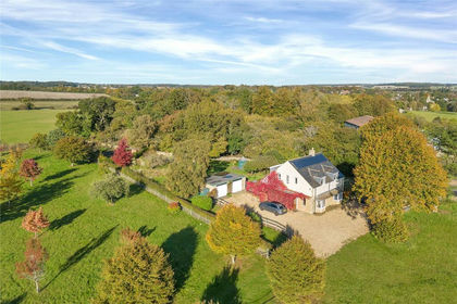
- Price
- Guide Price£850,000
- Size
- 3.7 acres
Linley Cottage, Wansford, Yarwell, North Northamptonshire PE8 England
Added on 16/09/2026House with Land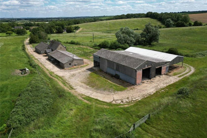
- Price
- Guide Price£850,000
- Size
- 59.55 acres
Added on 09/09/2026Agricultural Land