Little Catworth Farm, Little Catworth, Huntingdon, Cambridgeshire, PE28
- Land size
- 59.55 acres
Key Features
- 59.55 Acres of Arable and Grass Land.
- Agricultural Barns.
- Stables, Workshop and Further Stone Barns.
- Rural Location.
- Countryside Views.
Description
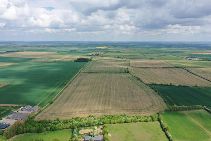
Arable and grass land extending to approximately 59.55 acres (24.10 hectares) in total, complemented by a selection of barns including stables, a threshing barn, workshop and pole barns. Situated in a sought-after position on the outskirts of the well-regarded village of Catworth.
Description
Arable and grass land extending to approximately 59.55 acres (24.10 hectares) in total, complemented by a selection of barns including stables, threshing barn, workshop and pole barns. Situated in a sought-after position on the outskirts of the well-regarded village of Catworth.
The Land
The land extends to approximately 59.55 acres of grassland and arable land, offering potential for agricultural, grazing and equestrian uses. According to the Natural England Agricultural Land Classification Maps, the eastern block of land is classified as Grade 3, while the western block is classified as Grade 2. The soils are described as lime-rich loamy and clayey soils with impeded drainage. Access is provided via the main farm drive, with the individual fields connected by a network of field gates. Boundaries are defined by mature hedgerows and post-and-wire fencing, with a woodland area bordering the north-east of the land.
Agricultural Barns
The land benefits from an extensive range of outbuildings and barns, offering excellent versatility for equestrian, agricultural or leisure use (STPP). These include three stables, providing ample capacity for equestrian pursuits (subject to planning). A substantial workshop offers generous space for machinery, storage or business use (STPP), while a collection of stone-built barns is thoughtfully utilised, creating a unique and characterful setting. In addition, there are further agricultural barns, well-suited for general farming purposes or adaptable to a variety of uses, subject to the necessary consents.
Threshing Barn (main barn approx. 14 m x 5.5 m)
Approached from the main drive accessed via timber double doors and glazed porch, the threshing barn features exposed brickwork extending to a vaulted ceiling. The hall leads to WCs and a kitchen area, and in turn connects to open covered areas and the garage and workshop, with further access through to the stables. This barn previously benefited from planning consent for use as an educational centre focused on promoting British food and traditional farming practices. WC partitions are already installed; however, plumbing and electrical work would be required to complete the second fix.
Steel Portal Framed Barns
A steel portal frame building with cladded elevations and roof, featuring a roller shutter door to one side. Adjoining is a steel-framed lean-to with a sliding door opening onto the yard, all set on a concrete floor. There is an additional open-sided steel portal frame barn with a hardcore floor.
Location
Little Catworth Farm is attractively situated down a lane on the edge of the sought-after village of Catworth, a charming rural community in the north-west of Cambridgeshire, close to the Northamptonshire border. The A14 and A1(M) are both readily accessible. Mainline railway stations at Huntingdon and St Neots offer regular services to London King’s Cross and St Pancras. The farm itself benefits from a peaceful and private setting, with a few neighbouring properties.
GPS Location Search
what3words: ///upwardly.candles.judge
Sporting, Timber & Mineral Rights
The mineral rights are excluded from the sale; they are held by the Church. All other rights are believed to be held with the freehold owner and will be included within a sale of the land.
Wayleaves, Easements and Rights of Way
We have been advised that there is a wayleave for the electric supply serving the property, barns and neighbouring houses. There are two footpaths crossing the land leading towards Catworth (more information can be found in our property information pack).
Restrictive Covenant
A restrictive covenant is in place preventing the use of the farmland for anything other than agricultural activities and not to erect any buildings unless previously approved by the Church Commissioners. There is provision within field 9974 to allow equestrian and camping or glamping. The area around and including the buildings are free from this covenant.
VAT
VAT will be charged on the land element of the transaction only.
Services
We have been advised that the barns and neighbouring house have separate electric meters. Interested parties are advised to make enquiries with the relevant utility companies.
Planning
No formal enquiries have been made, there may be potential for conversion into alternative uses, subject to applying for the appropriate planning consents from the Local Authority. This is also subject to resolving the position with the Restrictive Covenants.
Lotting
The property is for sale as a whole and the vendor reserves the right to offer the property in any order other than that described in these particulars, to sub-divide, amalgamate or withdraw the property from sale without prior notice.
Method of Sale
The freehold is for sale with vacant possession upon completion.
Registered Title
CB323153. The title will need splitting on completion.
Local Authority
Huntingdonshire District Council, 28 St. Marys Street, Huntingdon, PE29 3TN. Tel: . (
Property Information Pack
More information is available on request.
Anti-Money Laundering
The successful purchaser will be required to complete anti-money laundering compliance checks. The cost is £20.00 per individual, plus £60.00 applicable for company checks.
Viewing Arrangements
Strictly by appointment only. Please contact Kettering Sales on .
Map Location
Property details
- Tenure
- Freehold
- Council Tax Band
- E
- Date Posted
- 2026-09-09
Market Value Analysis
Compared with 42 Farmland & Pasture listings in East Anglia (50+ acres).
Utilities & Restrictions
Utilities
- Electricity
- Ask Agent
- Water
- Ask Agent
- Heating
- Ask Agent
- Broadband
- Ask Agent
- Sewerage
- Ask Agent
Rights & Restrictions
- Public Rights of Way
- Ask Agent
- Private Rights of Way
- Ask Agent
- Listed Property
- Ask Agent
- Restrictions
- Ask Agent
Listed status, conservation areas and planning constraints for this location are in the full report.
Property Features
- Accessibility
- Ask Agent
- Parking
- Parking Available
- Garden
- Garden
Beyond the particulars: planning activity, flood history, heritage and ground risks, checked for this exact spot.
Connectivity
Broadband
Fastest speed available at this postcode
23 Mbps
Standard (10-30 Mbps)
Suitable for
- Web & social
- Music streaming
- Standard video calls
Mobile signal
Outdoor predictions; indoor signal depends on building materials.
Ofcom Connected Nations postcode-level predictions. Speeds and signal are modelled, not measured, and vary between addresses and providers.
Signal is the easy part. Planning activity, flood history and protected designations here are in the full report.
Nearest Schools
Primary
- Spaldwick Primary School1.6 milesOfsted: Good *
- Ages
- 4 to 11
- Pupils
- 104
- Type
- Academy converter
- Brington CofE Primary School2.1 milesNo Ofsted rating
- Ages
- 4 to 11
- Pupils
- 94
- Type
- Voluntary controlled school
- Faith
- Church of England
- Kimbolton Primary Academy2.8 milesNo Ofsted rating
- Ages
- 2 to 11
- Pupils
- 59
- Type
- Academy sponsor led
- Eileen Wade Primary School4.6 milesOfsted report card · Dec 2025
- Ages
- 4 to 11
- Pupils
- 70
- Type
- Foundation school
- Great Staughton Primary Academy5.3 milesOfsted report card · Jan 2026
- Ages
- 2 to 11
- Pupils
- 80
- Type
- Academy converter
Secondary
- Manor School6.2 milesOfsted: Inadequate
- Ages
- 11 to 19
- Pupils
- 851
- Type
- Academy converter
- Hinchingbrooke School7.8 milesOfsted report card · May 2026
- Ages
- 11 to 18
- Pupils
- 2,173
- Type
- Academy converter
- Sawtry Village Academy7.9 milesNo Ofsted rating
- Ages
- 11 to 18
- Pupils
- 1,101
- Type
- Academy converter
- St Peter's School8.5 milesOfsted report card · May 2026
- Ages
- 11 to 18
- Pupils
- 1,506
- Type
- Academy converter
- The Ferrers School9 milesOfsted report card · Mar 2026
- Ages
- 11 to 18
- Pupils
- 937
- Type
- Academy converter
* Latest graded judgement covers quality of education only; no overall grade was issued under the 2024-25 inspection framework.
Distances are straight-line from the advertised location. Source: the national school registers (DfE, Welsh Government, Scottish Government) and Ofsted.
Schools are just the start: sold prices nearby, planning activity and any flood history are in the full report.
Amenities
Supermarket
GP surgery
Pharmacy
Hospital
Green space
Straight-line distances from the advertised location. Sources: NHS records, Geolytix supermarket locations, OS Open Greenspace and the national trails registers.
The area stacks up? Now check the location itself: planning nearby, protected designations and past flooding.
Getting Around
Nearest station
Nearest bus stop
Typical drive times
Straight-line distances from the advertised location; drive times are typical free-flow times over OpenStreetMap road data, so allow more at peak. Public transport locations from DfT NaPTAN.
Easy to reach matters. So do planning activity, flood history and ground risks: all in the full report.
Flood Risk
From Environment Agency flood map open data, checked around the advertised map pin and allowing for the listed acreage where known. This summary comes from LandSale, the advertising platform, not from the listing agent, and is not part of the agent's particulars. Risk can vary across a single holding, so verify anything critical through your own searches before committing.
Rivers and the sea
Surface water
Mapped within the area searched, not at the advertised map pin itself.
The detail behind these bandings
The full report pinpoints where this location sits on the flood maps, and runs the deeper checks that usually only surface after an offer.
- Exact flood zones & annual chances (included in the full report)
- Any recorded past flooding (included in the full report)
- Planning activity nearby (included in the full report)
- Heritage & conservation (included in the full report)
- Protected nature designations (included in the full report)
- Ground risks (included in the full report)
- Sold prices nearby (included in the full report)
£14.99 · one-off purchase
By LandSale, the platform. Not provided by the listing agent. Ready in about a minute.
Important notice: Information, maps and tags on this page are drawn from the advertising agent's marketing materials or generated automatically. LandSale has not verified them. Relying on these details is at your own risk, always carry out independent checks before committing to a purchase.
LandSale full disclaimer
Marketing information only - not formal particulars. The details on this website are provided for general guidance and do not constitute an offer or contract. Neither LandSale nor the advertising estate/land agent accepts responsibility for any inaccuracy.
1. Source of information
- Listing content: Core description, asking price, tenure, measurements, photographs and planning history originate from the marketing materials of the advertising estate or land agent. LandSale does not author this content and cannot guarantee its accuracy.
- Automated tags & categorisation: Property type, land-use class, acreage bands and similar labels may be applied by machine-learning models. They are intended as a helpful guide only and may not reflect the property's legal status or permitted use.
- Third-party & enriched data layers: Maps, boundary outlines, planning designations, soil reports, broadband coverage and other environmental or location-based insights are licensed from external suppliers. Such data are supplied “as is", may be incomplete or out of date and are subject to change without notice.
2. Verification required
Prospective purchasers must verify critical matters, including but not limited to planning permission, title boundaries, public rights of way, environmental constraints, acreage, services, access and VAT status, through their own inspections, specialist surveys, legal advisers and the selling agent before relying on the information or entering into any contract.
3. No warranty or liability
LandSale gives no warranty, express or implied, as to the accuracy, completeness or fitness for any particular purpose of the information displayed. LandSale shall not be liable for any loss, damage, cost or expense arising directly or indirectly from any use of or reliance on such information, save where liability may not be excluded by law.
4. Updates & feedback
If you believe any detail on this listing is inaccurate, please let us know. We will investigate and, where appropriate, update the listing or notify the agent.
© LandSale | Version 1.3 - August 2026
Listing agent
Berrys, Kettering
42 Headlands, Kettering, NN15 7HR
Similar properties for sale
- Price
- Guide Price£770,000
- Size
- 82.65 acres
Added on 31/05/2026Farmland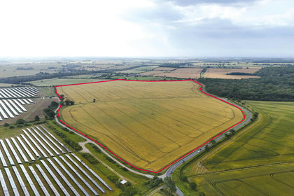
- Price
- Guide Price£930,000
- Size
- 101.58 acres
Land At, Woodwalton, Huntingdon, Cambridgeshire, PE28, Wood Walton, Cambridgeshire PE28 England
Added on 02/08/2026Arable Land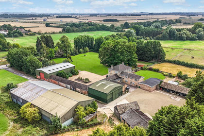
- Price
- Guide Price£745,000
- Size
- 49.62 acres
Lot 2 - West End Farm, Fenstanton, Huntingdon, Fenstanton, Cambridgeshire PE28 England
Added on 09/09/2026Agricultural Land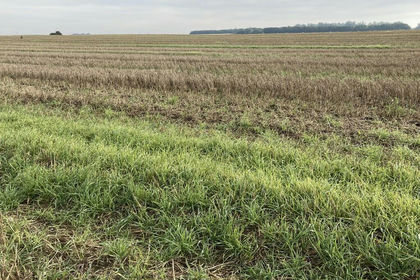
- Price
- £900,000
- Size
- 71.98 acres
Manea Road, Wimblington, March, Wimblington, Cambridgeshire PE15 England
Added on 29/01/2026Arable Land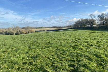
- Price
- Guide Price£710,000
- Size
- 64.61 acres
Pastureland Off The Ridgeway, Barby, CV23, Barby, West Northamptonshire CV23 England
Added on 28/01/2026Farmland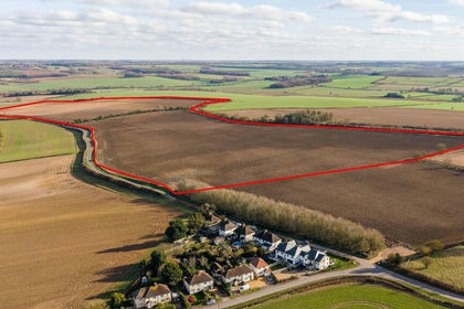
- Price
- Guide Price£800,000
- Size
- 89.35 acres
Lot 7 - Land Nr Kirtling And Ashley, Kirtling, Cambridgeshire CB8 England
Added on 01/09/2026Farmland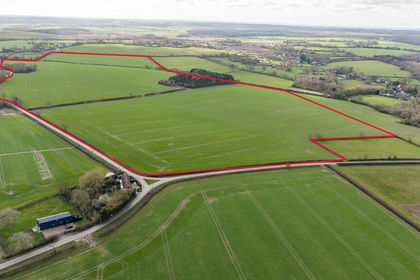
- Price
- Guide Price£950,000
- Size
- 89.35 acres
Lot 4 - Land Nr Kirtling And Ashley, Kirtling, Cambridgeshire CB8 England
Added on 01/09/2026Farmland