The Heights, Keldholme
- Land size
- 1.1 acres
- Bedrooms
- 4
- Bathrooms
- 4
Key Features
- Detached house standing in a third of an acre
- House extending to nearly 2700 sq ft
- Energy efficient and economical to run
- Integral garage and car port
- Gated driveway offering generous parking
- Paddock of 0.8 acres with a wildlife pond and orchard
- Range of outbuildings
- Convenient location with easy access via the A170
Description
Appealing family house situated along a private lane, with landscaped gardens, paddock and outbuildings.
The Heights is a modern, detached country house, one of just three similar properties set along a private no-through lane on the upper edge of the village. Elevated above its surroundings, the house enjoys an attractive outlook across its own paddock and the open countryside beyond.
Since 2020, the property has undergone a programme of considered upgrading, creating a spacious, versatile and energy-efficient home well suited to modern family life in the country. In addition to the house, there is an integral double garage, car port, landscaped private garden and, across the lane, an enclosed paddock with a range of useful outbuildings - providing an exceptional combination of space for family life and recreation.
Entrance and staircase hall, kitchen breakfast room, wc, utility room, wet room, 2 reception rooms, 4 bedrooms (2 with en suite bathrooms and dressing rooms), house bathroom
Garden studio /home office
Integral double garage, car port, gated parking for multiple cars, garden shed
Landscaped garden with pavilion
Stable block, greenhouse, open barn, workshop, store
Paddock
In all approximately 1.1 acres
Find Out A Little More.... - The Heights is a brick-and-pantile house constructed in the early 1990s and subsequently comprehensively upgraded. Energy efficiency has been given particular consideration, with a ground source heat pump and solar energy system forming part of the specification, providing efficient heating and on-site renewable energy.
The open-plan kitchen/breakfast room forms the heart of the home, providing a generous space for everyday family life. Double aspect, with a door opening directly onto the rear garden, the room is fitted with a peninsula island incorporating a breakfast bar, granite work surfaces, Bosch gas hob and extractor, integrated Bosch ovens and SMEG appliances. A large adjoining utility room provides additional practical space and incorporates a separate wet room/wc.
Glazed double doors lead into the dining room with an outlook over the garden, while the sitting room spans the depth of the house. A wood-burning stove creates a natural focal point and a large sliding door opens directly onto the patio, connecting the principal living space with the rear garden.
The entrance hall features a double-height ceiling, arched window and handsome turning staircase, which has open treads and a glass balustrade.
Four generous double bedrooms are arranged either side of the first-floor landing, three with fitted wardrobes. Two are bedroom suites incorporating a dressing room, bathroom and eaves storage. The en suite bathrooms are fitted with quality sanitaryware and Amtico flooring, and the large house bathroom is similarly finished and includes both a bath and separate shower.
Outside - Timber gates open to a generous parking and turning area that sweeps in front of the integral double garage with electric roller door and car port with EV charger. Behind a secure side gate is a garden shed and log store.
The north-western boundary is formed by a grassy bank planted with buddleia and screened by a mature evergreen laurel hedge, creating an effective buffer from the country road. In front of this is an expansive area of lawn, edged by established borders with a circular brick-edged patio, accessed directly from the sitting room.
At the front of the property, the landscaped garden has been thoughtfully designed for relaxed outdoor living and privacy. Curving gravel pathways weave through areas of lawn, with flowering perennials along the boundaries and raised beds planted with ornamental grasses, creating a naturalistic yet well-structured setting with interest throughout the seasons.
At the heart of the garden is an elevated timber-framed pavilion, approached beneath a rose-covered arbour and framed by climbing plants. It provides an attractive al fresco dining terrace and a sheltered place from which to enjoy the garden.
A detached cedar-clad garden studio is a versatile, ancillary living space, suitable for use as a home office, gym or creative retreat. Extending to 277 sq ft, the studio is insulated and fitted with double-glazed windows, electric heaters, power, lighting and an internet connection. Bifold doors open wide onto the paved terrace with views across the garden.
Paddock & Outbuildings - Opposite the house, on the other side of Kraig Lane, lies the enclosed paddock extending to approximately 0.8 acres. It is accessed through a five-bar gate and provides a valuable area for family recreation.
An irrigation system drains into a wildlife pond, which has been planted and landscaped with a seating area and sheltering yew hedge. Young planting along the eastern corner of the paddock is becoming established as a shelterbelt. There is also an established orchard containing a variety of fruit trees, together with a fruit cage and vegetable patch, creating a productive extension to the garden.
The outbuildings have recently been re-roofed in metal.
The detached stable block with railed yard comprises four loose boxes and is currently used for storage. It offers considerable flexibility for future use.
A further barn, together with adjoining workshop, store and greenhouse, is positioned within a secure, enclosed gravelled compound. The compound has a water supply and is accessed through secure gates. Attached to the open barn is a store and secure workshop, both with power and lighting.
Environs - Helmsley and Pickering 6 miles, Malton 12 miles, Thirsk 21 miles, Yorkshire coast 24 miles, York 27 miles
Keldholme is a small hamlet situated alongside the river Dove, on the outskirts of Kirkbymoorside and close to the A170 Thirsk-Scarborough Road, less than a mile from the North York Moors.
Kirkbymoorside is a traditional market town offering a good range of everyday amenities, including independent shops, a market, primary school, sports clubs and an 18-hole golf course. Ryedale School, rated Outstanding by Ofsted, is approximately four miles away, while independent schooling in the immediate region can be found at Scarborough, Terrington and Ampleforth.
The market towns of Helmsley, Pickering and Malton are very accessible with Malton Railway Station providing a direct connection to York, Leeds and Manchester, and the mainline service at York operating a fast service to London.
Important Information - Tenure: Freehold
EPC Rating: C
Council Tax Band: G
Services & Systems: Mains water, electricity and gas. Ground source heat pump and UV solar energy system. Private drainage. Security alarm. CAT5 wiring.
Fixtures & Fittings: All items in the written text of these particulars are included in the sale. All others are expressly excluded regardless of inclusion in any photographs. Purchasers must satisfy themselves that any equipment included in the sale of the property is in satisfactory order.
Local Authority: North Yorkshire Council
Money Laundering Regulations: Prior to a sale being agreed, prospective purchasers are required to produce identification documents in order to comply with Money Laundering regulations. Your co-operation with this is appreciated and will assist with the smooth progression of the sale.
Directions: From the A170, just east of Kirkbymoorside, take the road north signposted Keldholme. Continue for a few hundred metres, following the road to the right, and then take a sharp, right hand turn for Kraig Lane, just before the National Speed Limit sign. The house is the first on the right hand side.
What3words: ///half.prouder.husband
Viewing: Strictly by appointment
Photographs, images, brochure and property highlights video: August. Some images may have been enhanced using artificial intelligence (AI); any such images will be clearly identified individually. Google map images may neither be current nor a true representation.
Map Location
Property details
- Tenure
- Freehold
- Council Tax Band
- G
- Date Posted
- 2026-10-08
Market Value Analysis
Compared with 675 Homes with Land listings in Yorkshire and The Humber (1+ acres).
Energy Performance Certificate
Energy Efficiency Rating
Based on UK Energy Performance Certificate standards (EU Directive 2002/91/EC)
Running costs are one side. Planning activity, flood history and ground risks for this location are in the full report.
Utilities & Restrictions
Utilities
- Electricity
- Ask Agent
- Water
- Ask Agent
- Heating
- Ask Agent
- Broadband
- Ask Agent
- Sewerage
- Ask Agent
Rights & Restrictions
- Public Rights of Way
- Ask Agent
- Private Rights of Way
- Ask Agent
- Listed Property
- Ask Agent
- Restrictions
- Ask Agent
Listed status, conservation areas and planning constraints for this location are in the full report.
Property Features
- Accessibility
- Ask Agent
- Parking
- Parking Available
- Garden
- Garden
Beyond the particulars: planning activity, flood history, heritage and ground risks, checked for this exact spot.
Connectivity
Broadband
Fastest speed available at this postcode
77 Mbps
Superfast
Suitable for
- HD streaming
- Video calls
- Web & social
Fixed wireless access may also be an option here.
Mobile signal
Predicted 4G and 5G signal; indoor signal depends on building materials.
Ofcom Connected Nations postcode-level predictions. Speeds and signal are modelled, not measured, and vary between addresses and providers.
Signal is the easy part. Planning activity, flood history and protected designations here are in the full report.
Nearest Schools
Primary
- Kirkbymoorside Community Primary School1.2 milesOfsted: Good
- Ages
- 3 to 11
- Pupils
- 181
- Type
- Academy converter
- Sinnington Community Primary School1.9 milesNo Ofsted rating
- Ages
- 2 to 11
- Pupils
- 110
- Type
- Academy converter
- Gillamoor Church of England Voluntary Controlled Primary School2.8 milesNo Ofsted rating
- Ages
- 4 to 11
- Pupils
- 61
- Type
- Voluntary controlled school
- Faith
- Church of England
- Nawton Community Primary School3.4 milesOfsted report card · Mar 2026
- Ages
- 3 to 11
- Pupils
- 90
- Type
- Community school
- St Joseph's Catholic Primary School - a Catholic voluntary academy5.2 milesNo Ofsted rating
- Ages
- 3 to 11
- Pupils
- 84
- Type
- Academy converter
- Faith
- Roman Catholic
Secondary
- Ryedale School3.6 milesOfsted: Outstanding
- Ages
- 11 to 16
- Pupils
- 698
- Type
- Academy converter
- Lady Lumley's Academy5.3 milesOfsted: Good
- Ages
- 11 to 18
- Pupils
- 676
- Type
- Academy sponsor led
- Malton School9.8 milesOfsted: Good
- Ages
- 11 to 18
- Pupils
- 999
- Type
- Academy converter
- Norton School11 milesOfsted: Good
- Ages
- 11 to 18
- Pupils
- 651
- Type
- Academy converter
- Outwood Academy Easingwold15 milesOfsted: Outstanding
- Ages
- 11 to 18
- Pupils
- 823
- Type
- Academy sponsor led
Distances are straight-line from the advertised location. Source: the national school registers (DfE, Welsh Government, Scottish Government) and Ofsted.
Schools are just the start: sold prices nearby, planning activity and any flood history are in the full report.
Amenities
Supermarket
GP surgery
Pharmacy
Hospital
Green space
Straight-line distances from the advertised location. Sources: NHS records, Geolytix supermarket locations, OS Open Greenspace and the national trails registers.
The area stacks up? Now check the location itself: planning nearby, protected designations and past flooding.
Getting Around
Nearest station
Nearest bus stop
Typical drive times
Straight-line distances from the advertised location; drive times are typical free-flow times over OpenStreetMap road data, so allow more at peak. Public transport locations from DfT NaPTAN.
Easy to reach matters. So do planning activity, flood history and ground risks: all in the full report.
Flood Risk
Environment Agency open data, checked around the advertised map pin for the listed acreage. Long-term risk counts flood defences; the planning map's flood zones do not. Provided by LandSale, not the listing agent, and not part of the agent's particulars. Risk varies across a holding, so verify before committing.
Rivers and the sea
Planning map: Flood Zone 2.
Surface water
Not at the pin: mapped about 20 metres away.
These bandings are the summary. Where this location sits on the flood maps, plus planning activity, heritage and ground risks, is in the full report.
Important notice: Information, maps and tags on this page are drawn from the advertising agent's marketing materials or generated automatically. LandSale has not verified them. Relying on these details is at your own risk, always carry out independent checks before committing to a purchase.
LandSale full disclaimer
Marketing information only - not formal particulars. The details on this website are provided for general guidance and do not constitute an offer or contract. Neither LandSale nor the advertising estate/land agent accepts responsibility for any inaccuracy.
1. Source of information
- Listing content: Core description, asking price, tenure, measurements, photographs and planning history originate from the marketing materials of the advertising estate or land agent. LandSale does not author this content and cannot guarantee its accuracy.
- Automated tags & categorisation: Property type, land-use class, acreage bands and similar labels may be applied by machine-learning models. They are intended as a helpful guide only and may not reflect the property's legal status or permitted use.
- Third-party & enriched data layers: Maps, boundary outlines, planning designations, soil reports, broadband coverage and other environmental or location-based insights are licensed from external suppliers. Such data are supplied “as is", may be incomplete or out of date and are subject to change without notice.
2. Verification required
Prospective purchasers must verify critical matters, including but not limited to planning permission, title boundaries, public rights of way, environmental constraints, acreage, services, access and VAT status, through their own inspections, specialist surveys, legal advisers and the selling agent before relying on the information or entering into any contract.
3. No warranty or liability
LandSale gives no warranty, express or implied, as to the accuracy, completeness or fitness for any particular purpose of the information displayed. LandSale shall not be liable for any loss, damage, cost or expense arising directly or indirectly from any use of or reliance on such information, save where liability may not be excluded by law.
4. Updates & feedback
If you believe any detail on this listing is inaccurate, please let us know. We will investigate and, where appropriate, update the listing or notify the agent.
© LandSale | Version 1.3 - August 2026
Listing agent
Blenkin & Co, York
Priestley House Bootham York YO30 7BL
Similar properties for sale
- Price
- Guide Price£895,000
- Size
- 8.18 acres
Lytel Garth, Keldholme, Kirkbymoorside, York, Kirkbymoorside, North Yorkshire YO62 England
Added on 09/04/2026House with Land
- Price
- Offers in Excess of£845,000
- Size
- 2 acres
Hutton-Le-Hole, York, Hutton-le-Hole, North Yorkshire YO62 England
Added on 29/01/2026House with Land
- Price
- Guide Price£650,000
- Size
- 2.1 acres
Keld Head Road, York, Kirkbymoorside, North Yorkshire YO62 England
Added on 29/01/2026Development Land
- Price
- Guide Price£955,000
- Size
- 3.3 acres
Hutton-Le-Hole, York, Hutton-le-Hole, North Yorkshire YO62 England
Added on 28/01/2026House with Land
- Price
- Offers Over£895,000
- Size
- 1.7 acres
Potters Lodge, Marton, Sinnington, YO62, Marton, North Yorkshire YO62 England
Added on 14/03/2026House with Land
- Price
- Guide Price£975,000
- Size
- 1.12 acres
Gales House Farm Cottages, Kirkby Lane, Gillamoor, York, Gillamoor, North Yorkshire YO62 England
Added on 16/04/2026Holiday Let Property
- Price
- £895,000
- Size
- 2.74 acres
Main Street, Wombleton, York, Wombleton, North Yorkshire YO62 England
Added on 12/08/2026House with Land
- Price
- Guide Price£625,000
- Size
- 4.56 acres
Rudland, Fadmoor, York, Fadmoor, North Yorkshire YO62 England
Added on 28/08/2026House with Land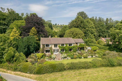
- Price
- Offers in Excess of£1,000,000
- Size
- 1.6 acres
West End, Ampleforth, York, Ampleforth, North Yorkshire YO62 England
Added on 09/09/2026House with Land
- Price
- Guide Price£650,000
- Size
- 23.4 acres
Added on 29/01/2026Barn Conversion