Arne, Wareham, Dorset
- Land size
- 4 acres
- Bedrooms
- 4
- Bathrooms
- 2
Key Features
- Stunning location set amongst RSPB Arne Nature Reserve
- Views of Poole Harbour and far-reaching countryside and sea views
- Wrap-around terrace to enjoy the views from all aspects
- Secluded hamlet of Arne
- Spacious, versatile accommodation
- Close to Wareham and trainline to London Waterloo
Description
Welcome to The Orchard, a beautiful, spacious country residence set in the heart of the RSPB Arne Nature Reserve and the beautiful countryside of the Isle of Purbeck.
The wrap-around gardens include formal lawns with established planting, Poole Harbour views from the terrace and a grassland paddock, making the plot a generous area of approx. 4 acres.
The expansive views of Arne and out towards Poole Harbour are magnificent and are just one of the amazing features of this property. There are only a handful of private properties in Arne and The Orchard offers peace, tranquility and stunning views in abundance.
Entering through the FRONT PORCH which has a vaulted ceiling, after stepping through the vestibule, you are welcomed into a fabulous, spacious RECEPTION HALL, oozing charm and complete with stone fireplace and log burner to offer warmth from the cold outside. The oak staircase leads from here to the first floor accommodation.
The STUDY comes complete with fitted desk, drawers and storage cupboards and has a delightful outlook over the front garden. An ideal, peaceful room, tucked away from the rest of the house, perfect if you are looking for a work from home office.
Leading on from the inner hallway, a door leads into the large SITTING ROOM, where views over the gardens can be seen through every window. A large brick fireplace with a polished Purbeck Stone hearth is the heart of this room, with a log burner for those cosy winter nights in front of the fire. A door from here leads into the octagonal CONSERVATORY with has 180-degree views of the gardens.
The large KITCHEN/BREAKFAST ROOM has a beautiful oak floor and space for a family table, with French doors opening onto the terrace, a perfect place to sit and enjoy breakfast in the sun, sipping coffee and listening to the birdsong.
The KITCHEN has granite worktops with ample cupboards, breakfast bar and fitted Bosch™ appliances including double oven, ceramic hob, dishwasher and microwave. A door connects to the UTILITY ROOM with more storage cupboards and plumbing and space for washing machine and tumble dryer.
The DINING ROOM also has French doors opening out onto the wrap around terrace, great for entertaining family and friends on a summers' evening.
A door leads from the utility room to a lobby with a SECOND STUDY, again with French doors to the garden. There is also a door to the WORKSHOP/BOOTROOM, an ideal place for home hobbies or working on those home projects. A door leads into the PLANT ROOM which houses the heating boiler, water cylinder and air source heat pump. There is also a W.C., and wash basin.
The oak staircase leads from the reception hall to the first floor accommodation. There is an airing cupboard and a linen cupboard here too.
The PRINCIPAL BEDROOM is a spacious, bright and sunny room with spectacular far reaching, panoramic views of Poole Harbour, including islands such as Brownsea Island and Furzey Island, and on a clear day you can also see as far as the Isle of Wight. An archway leads through to the DRESSING ROOM with fitted wardrobes and dressing table, and again those amazing views. The EN-SUITE BATHROOM is fully tiled with a bath, bidet, separate shower, W.C., and wash basin.
There are two further DOUBLE BEDROOMS with fitted furniture and a large single BEDROOM with built in storage. The windows from every room upstairs draw you to the views of the wonderful countryside beyond.
The family BATHROOM is fully tiled and has a bath, W.C., and wash basin.
Outside
The outdoor space for this country home is so versatile. Stunning formal gardens surround the property, and a wraparound terrace enables a selection of seating areas and entertaining spaces making the most of the sunshine throughout the day.
There is a DOUBLE/TRIPLE GARAGE with a converted loft STUDIO above, with heating and A/C. One could use this space for a work from home business, for hobbies, or an arts and craft workshop or music studio.
There are several outbuildings including SHEDS and GARDEN STORES, and a SUMMER HOUSE for enjoying some shade in the height of summer.
There is also a PADDOCK of approx. 3 acres, great for keeping livestock or just enjoying the space and privacy.
There is ample parking on the driveway for several vehicles once through the electric double gates, and access to the GARAGES and workshop.
There is an additional paddock of approx 5 acres, which could be purchased as a seperate transaction.
Location
Peacefully located in the sought after area of Arne and in close proximity to the Yacht Club, Arne Nature Reserve and the many natural walks in the area. Approximately 4 miles from the riverside market town of Wareham. Wareham itself is the “gateway” to the Isle of Purbeck with its eclectic mix of shops, restaurants and galleries and mainline railway links to London/Waterloo (2 hours). Good local and private schools are located nearby.
Directions
Use what3words.com to navigate to the exact spot. Search using: breath.always.vibes
ROOM MEASUREMENTS
Please refer to floor plan.
SERVICES
Mains electricity, air source heat pump & septic tank.
LOCAL AUTHORITY
Dorset (Purbeck) Council, tax band G.
TENURE
Freehold.
LETTINGS
Should you be interested in acquiring a Buy-to-Let investment, and would appreciate advice regarding the current rental market, possible yields, legislation for landlords and how to make a property safe and compliant for tenants, then find out about our Investor Club from our expert, Alexandra Holland. Alexandra will be pleased to provide you with additional, personalised support; just call her on the branch telephone number to take the next step.
IMPORTANT NOTICE
DOMVS and its Clients give notice that: they have no authority to make or give any representations or warranties in relation to the property. These particulars do not form part of any offer or contract and must not be relied upon as statements or representations of fact. Any areas, measurements or distances are approximate. The text, photographs (including any AI photography) and plans are for guidance only and are not necessarily comprehensive. It should not be assumed that the property has all necessary Planning, Building Regulation or other consents, and DOMVS has not tested any services, equipment or facilities. Purchasers must satisfy themselves by inspection or otherwise. DOMVS is a member of The Property Ombudsman scheme and subscribes to The Property Ombudsman Code of Practice.
Map Location
Property details
- Tenure
- Freehold
- Council Tax Band
- G
- Date Posted
- 2026-07-30
Market Value Analysis
Compared with 1,719 Homes with Land listings in South West England (1+ acres).
Energy Performance Certificate
Energy Efficiency Rating
Based on UK Energy Performance Certificate standards (EU Directive 2002/91/EC)
Running costs are one side. Planning activity, flood history and ground risks for this location are in the full report.
Utilities & Restrictions
Utilities
- Electricity
- Ask Agent
- Water
- Ask Agent
- Heating
- Ask Agent
- Broadband
- Ask Agent
- Sewerage
- Ask Agent
Rights & Restrictions
- Public Rights of Way
- Ask Agent
- Private Rights of Way
- Ask Agent
- Listed Property
- Ask Agent
- Restrictions
- Ask Agent
Listed status, conservation areas and planning constraints for this location are in the full report.
Property Features
- Accessibility
- Ask Agent
- Parking
- Parking Available
- Garden
- Garden
Beyond the particulars: planning activity, flood history, heritage and ground risks, checked for this exact spot.
Connectivity
Broadband
Fastest speed available at this postcode
1.8 Gbps
Gigabit full fibre · available to 59% of premises
Suitable for
- 4K streaming on every screen
- Full-time home working
- Online gaming & big downloads
Mobile signal
Outdoor predictions; indoor signal depends on building materials.
Ofcom Connected Nations postcode-level predictions. Speeds and signal are modelled, not measured, and vary between addresses and providers.
Signal is the easy part. Planning activity, flood history and protected designations here are in the full report.
Nearest Schools
Primary
- Hamworthy Park Junior School2.1 milesOfsted: Good *
- Ages
- 7 to 11
- Pupils
- 458
- Type
- Academy converter
- Twin Sails Infant and Nursery School2.1 milesNo Ofsted rating
- Ages
- 3 to 7
- Pupils
- 320
- Type
- Academy converter
- Bayside Academy2.3 milesOfsted report card · Mar 2026
- Ages
- 4 to 11
- Pupils
- 180
- Type
- Academy sponsor led
- Sandford St Martin's Church of England Voluntary Aided Primary School2.8 milesOfsted: Good
- Ages
- 4 to 11
- Pupils
- 342
- Type
- Voluntary aided school
- Faith
- Church of England
- Upton Junior School3 milesOfsted: Good
- Ages
- 7 to 11
- Pupils
- 351
- Type
- Academy converter
Secondary
- The Cornerstone Academy2.2 milesNo Ofsted rating
- Ages
- 11 to 16
- Pupils
- 645
- Type
- Academy sponsor led
- Poole High School3.3 milesNo Ofsted rating
- Ages
- 11 to 18
- Pupils
- 1,891
- Type
- Academy converter
- Lytchett Minster School3.4 milesNo Ofsted rating
- Ages
- 11 to 19
- Pupils
- 1,624
- Type
- Foundation school
- The Purbeck School3.7 milesNo Ofsted rating
- Ages
- 11 to 18
- Pupils
- 1,022
- Type
- Academy converter
- Parkstone Grammar School4.3 milesOfsted: Good *
- Ages
- 11 to 18
- Pupils
- 1,241
- Type
- Academy converter
- Gender
- Girls
* Latest graded judgement covers quality of education only; no overall grade was issued under the 2024-25 inspection framework.
Distances are straight-line from the advertised location. Source: the national school registers (DfE, Welsh Government, Scottish Government) and Ofsted.
Schools are just the start: sold prices nearby, planning activity and any flood history are in the full report.
Amenities
Supermarket
GP surgery
Pharmacy
Hospital
Green space
Straight-line distances from the advertised location. Sources: NHS records, Geolytix supermarket locations, OS Open Greenspace and the national trails registers.
The area stacks up? Now check the location itself: planning nearby, protected designations and past flooding.
Getting Around
Nearest station
Nearest bus stop
Typical drive times
Straight-line distances from the advertised location; drive times are typical free-flow times over OpenStreetMap road data, so allow more at peak. Public transport locations from DfT NaPTAN.
Easy to reach matters. So do planning activity, flood history and ground risks: all in the full report.
Flood Risk
From Environment Agency flood map open data, checked around the advertised map pin and allowing for the listed acreage where known. This summary comes from LandSale, the advertising platform, not from the listing agent, and is not part of the agent's particulars. Risk can vary across a single holding, so verify anything critical through your own searches before committing.
Rivers and the sea
Surface water
These bandings are the summary. Where this location sits on the flood maps, plus planning activity, heritage and ground risks, is in the full report.
Important notice: Information, maps and tags on this page are drawn from the advertising agent's marketing materials or generated automatically. LandSale has not verified them. Relying on these details is at your own risk, always carry out independent checks before committing to a purchase.
LandSale full disclaimer
Marketing information only - not formal particulars. The details on this website are provided for general guidance and do not constitute an offer or contract. Neither LandSale nor the advertising estate/land agent accepts responsibility for any inaccuracy.
1. Source of information
- Listing content: Core description, asking price, tenure, measurements, photographs and planning history originate from the marketing materials of the advertising estate or land agent. LandSale does not author this content and cannot guarantee its accuracy.
- Automated tags & categorisation: Property type, land-use class, acreage bands and similar labels may be applied by machine-learning models. They are intended as a helpful guide only and may not reflect the property's legal status or permitted use.
- Third-party & enriched data layers: Maps, boundary outlines, planning designations, soil reports, broadband coverage and other environmental or location-based insights are licensed from external suppliers. Such data are supplied “as is", may be incomplete or out of date and are subject to change without notice.
2. Verification required
Prospective purchasers must verify critical matters, including but not limited to planning permission, title boundaries, public rights of way, environmental constraints, acreage, services, access and VAT status, through their own inspections, specialist surveys, legal advisers and the selling agent before relying on the information or entering into any contract.
3. No warranty or liability
LandSale gives no warranty, express or implied, as to the accuracy, completeness or fitness for any particular purpose of the information displayed. LandSale shall not be liable for any loss, damage, cost or expense arising directly or indirectly from any use of or reliance on such information, save where liability may not be excluded by law.
4. Updates & feedback
If you believe any detail on this listing is inaccurate, please let us know. We will investigate and, where appropriate, update the listing or notify the agent.
© LandSale | Version 1.3 - August 2026
Listing agent
DOMVS, Wareham
8 South Street, Wareham, BH20 4LT
Similar properties for sale
- Price
- Guide Price£1,750,000
- Size
- 5.84 acres
Brickyard Lane, Corfe Mullen, Wimborne, Corfe Mullen, Dorset BH21 England
Added on 14/05/2026Farmhouse
- Price
- £1,195,000
- Size
- 2 acres
Added on 28/03/2026Equestrian property
- Price
- £1,600,000
- Size
- 4 acres
Added on 01/09/2026House with Land
- Price
- Guide Price£1,195,000
- Size
- 2 acres
Matchams Lane, Hurn, BH23, Hurn, Bournemouth, Christchurch and Poole BH23 England
Added on 17/07/2026House with Land
- Price
- Guide Price£1,350,000
- Size
- 2.06 acres
High Street, Tarrant Monkton, Blandford Forum, DT11, Tarrant Monkton, Dorset DT11 England
Added on 17/09/2026House with Land
- Price
- Guide Price£1,250,000
- Size
- 8.66 acres
Ringwood Road, Three Legged Cross, Wimborne, Dorset, BH21, Verwood, Dorset BH21 England
Added on 30/05/2026Farmhouse
- Price
- £1,750,000
- Size
- 8 acres
Slough Lane, Horton, Wimborne, BH21, Woodlands, Dorset BH21 England
Added on 28/08/2026House with Land
- Price
- Guide Price£1,350,000
- Size
- 34 acres
Milton Abbas, Blandford Forum, Dorset, Milton Abbas, Dorset DT11 England
Added on 19/03/2026House with Land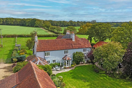
- Price
- £1,595,000
- Size
- 2.5 acres
Shirley, Bransgore, Christchurch, BH23, Sopley, Hampshire BH23 England
Added on 01/06/2026Farmhouse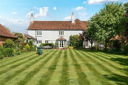
- Price
- Guide Price£1,595,000
- Size
- 2.5 acres
Shirley, Bransgore, Christchurch, Hampshire, BH23, Sopley, Hampshire BH23 England
Added on 12/06/2026Country Home