Stourpaine, Blandford Forum, Dorset, DT11
- Land size
- 4.25 acres
- Bedrooms
- 5
- Bathrooms
- 4
Key Features
- Stylish contemporary home with superb views
- Spacious Kitchen / dining space opening into garden
- 4 Bedrooms including downstairs bedroom suite
- Annex above gararge (5th bedroom)
- Charming gardens, Swimming pool, Studio
- Ground source heat pump and electric car-charging point
- Paddock of 2.6 acres with stabling
- In all about 4.25 acres
Description
A stunning contemporary home with beautiful far-reaching views over open countryside.
Ash Lodge is a fine example of an architect designed contemporary home, completed in 2008 to a high specification. Constructed of brick plinth and timber framed with a clay tile roof, the grey weather-board elevations are Douglas fir wood. Throughout the downstairs is oak flooring and underfloor heating, with radiators upstairs.
The house was extensively refurbished and improved by the current owners after purchasing in 2022, including a new ground source heat pump for the central heating which is underfloor to the ground floor, refinishing of the oak flooring, new cabinetry in the boot/utility room and pantry, upgrading of the kitchen, all four bathrooms were stylishly refitted to a high specification, and the swimming pool was relined with a new air source heat pump and cover. The accommodation is exceptionally versatile with the family room and bedroom with en suite on the ground floor interconnecting via pocket doors to provide a useful guest suite. In addition, the owners have built an excellent self-contained studio apartment over the double garage ideal for family, guest or staff use.
Steps lead from the front drive up to a wide veranda and to the front door which makes for a striking entrance to the house and into the double height ceiling hall with galleried landing above. Off the hall to the right is the guest bedroom suite with its own sitting room and ensuite shower room. The open plan kitchen/dining room is the main hub of the house, it is light and airy with doors leading out on to the terrace and garden beyond. The kitchen comprises a comprehensive range of cupboards with granite work tops and integral appliances and conveniently off the kitchen is a large pantry. From the dining end of this room you can enjoy wonderful views of the garden and countryside beyond. The sitting room is off the kitchen/dining room with French doors leading out to the decked terrace, this room has a wood burning stove.
Upstairs is a bright galleried landing off which are three double bedrooms, all with good storage cupboards. The main bedroom suite has an en suite bath/shower room and a dressing room and there are French doors leading out to a large balcony. There is also a separate family shower room for the other two bedrooms. For room layouts and measurements please see floor plans
Outside
Above the double garage is an annexe with open plan kitchen/living room and shower room. The garden is private with the boundary containing mature hedging and trees surrounded by woodland to the front and side which provides privacy. Lovely views across open farmland can be enjoyed from the rear of the property. The garden which extends to approximately an acre is mainly laid to lawn and formally planted. There are raised vegetable beds and a variety of fruit trees, mainly apple. Also a large swimming pool with pump house. There is a 2.5 acre paddock and four stables, the property has direct access to a bridleway.
EPC = D
SERVICES Private water supply, Private drainage. Ground Source heating. Air source heat pump (pool). Mains electricity.
LOCAL AUTHORITY Dorset Council
OUTGOINGS Council tax band G
BROADBAND: Wessex Internet. Fibre broadband. Upload speed 250 mbps. Download speed. 500 mbps.
Stourpaine is a delightful village situated on the northern bank of the River Stour with water meadows and lightly wooded hillsides. Local amenities include, the church with its 15th century tower and a village pub, Hod Hill can be accessed from the village and from the top of the hill there are outstanding views. Hod Hill was a prominent Iron Age hillfort that later became the site of a Roman auxiliary fort.
The market towns of Shaftesbury lie to the north of Stourpaine and Blandford Forum to the south. The beautiful Cathedral city of Salisbury is to the east with a wide selection of shops, restaurants, arts and recreational facilities. Trains from Salisbury to London Waterloo have a journey time of approximately 90 minutes.
Racing is available at Salisbury Racecourse and Wincanton and golf at Rushmore Park, South Wilts Golf Club and High Post.
There is a wide selection of both state and private schools in the area, including Port Regis, Sandroyd, Hanford, Clayesmore, Bryanston, Salisbury Cathedral School, Chafyn Grove, Kings School Bruton and Godolphin as well as Bishop Wordsworth and South Wilts Grammar Schools.
Map Location
Property details
- Tenure
- Freehold
- Council Tax Band
- TBC
- Date Posted
- 2026-09-01
Market Value Analysis
Compared with 1,624 Homes with Land listings in South West England (1+ acres).
Utilities & Restrictions
Utilities
- Electricity
- Ask Agent
- Water
- Ask Agent
- Heating
- Ask Agent
- Broadband
- Ask Agent
- Sewerage
- Ask Agent
Rights & Restrictions
- Public Rights of Way
- Ask Agent
- Private Rights of Way
- Ask Agent
- Listed Property
- Ask Agent
- Restrictions
- Ask Agent
Listed status, conservation areas and planning constraints for this location are in the full report.
Property Features
- Accessibility
- Ask Agent
- Parking
- Parking Available
- Garden
- Garden
Beyond the particulars: planning activity, flood history, heritage and ground risks, checked for this exact spot.
Connectivity
Broadband
Fastest speed available at this postcode
1 Gbps
Gigabit full fibre
Suitable for
- 4K streaming on every screen
- Full-time home working
- Online gaming & big downloads
Fixed wireless access may also be an option here.
Mobile signal
Predicted 4G and 5G signal; indoor signal depends on building materials.
Ofcom Connected Nations postcode-level predictions. Speeds and signal are modelled, not measured, and vary between addresses and providers.
Signal is the easy part. Planning activity, flood history and protected designations here are in the full report.
Nearest Schools
Primary
- Durweston Church of England Primary School1.2 milesOfsted report card · Feb 2026
- Ages
- 3 to 11
- Pupils
- 144
- Type
- Academy converter
- Faith
- Church of England
- Milldown CofE Academy2 milesOfsted: Good
- Ages
- 4 to 11
- Pupils
- 200
- Type
- Academy converter
- Faith
- Church of England
- Shillingstone Church of England Primary School2.3 milesOfsted: Good
- Ages
- 4 to 11
- Pupils
- 103
- Type
- Academy converter
- Faith
- Church of England
- Pimperne Church of England VC Primary School2.3 milesNo Ofsted rating
- Ages
- 4 to 11
- Pupils
- 183
- Type
- Academy converter
- Faith
- Church of England
- St Nicholas Church of England Primary School, Child Okeford2.5 milesOfsted report card · Mar 2026
- Ages
- 4 to 11
- Pupils
- 125
- Type
- Academy converter
- Faith
- Church of England
Secondary
- The Blandford School2.3 milesOfsted: Good
- Ages
- 11 to 18
- Pupils
- 1,103
- Type
- Voluntary controlled school
- Sturminster Newton High School5.8 milesOfsted report card · Apr 2026
- Ages
- 11 to 18
- Pupils
- 605
- Type
- Academy converter
- Shaftesbury School7.6 milesOfsted: Good
- Ages
- 11 to 18
- Pupils
- 782
- Type
- Academy converter
- Faith
- Church of England
- Queen Elizabeth's School10 milesOfsted: Requires improvement
- Ages
- 13 to 18
- Pupils
- 1,375
- Type
- Academy converter
- Faith
- Church of England
- Gillingham School11 milesOfsted: Good
- Ages
- 11 to 18
- Pupils
- 1,684
- Type
- Voluntary controlled school
Distances are straight-line from the advertised location. Source: the national school registers (DfE, Welsh Government, Scottish Government) and Ofsted.
Schools are just the start: sold prices nearby, planning activity and any flood history are in the full report.
Amenities
Supermarket
GP surgery
Pharmacy
Hospital
Green space
Straight-line distances from the advertised location. Sources: NHS records, Geolytix supermarket locations, OS Open Greenspace and the national trails registers.
The area stacks up? Now check the location itself: planning nearby, protected designations and past flooding.
Getting Around
Nearest station
Nearest bus stop
Typical drive times
Straight-line distances from the advertised location; drive times are typical free-flow times over OpenStreetMap road data, so allow more at peak. Public transport locations from DfT NaPTAN.
Easy to reach matters. So do planning activity, flood history and ground risks: all in the full report.
Flood Risk
Environment Agency open data, checked around the advertised map pin for the listed acreage. Long-term risk counts flood defences; the planning map's flood zones do not. Provided by LandSale, not the listing agent, and not part of the agent's particulars. Risk varies across a holding, so verify before committing.
Rivers and the sea
Planning map: Flood Zone 1.
Surface water
These bandings are the summary. Where this location sits on the flood maps, plus planning activity, heritage and ground risks, is in the full report.
Important notice: Information, maps and tags on this page are drawn from the advertising agent's marketing materials or generated automatically. LandSale has not verified them. Relying on these details is at your own risk, always carry out independent checks before committing to a purchase.
LandSale full disclaimer
Marketing information only - not formal particulars. The details on this website are provided for general guidance and do not constitute an offer or contract. Neither LandSale nor the advertising estate/land agent accepts responsibility for any inaccuracy.
1. Source of information
- Listing content: Core description, asking price, tenure, measurements, photographs and planning history originate from the marketing materials of the advertising estate or land agent. LandSale does not author this content and cannot guarantee its accuracy.
- Automated tags & categorisation: Property type, land-use class, acreage bands and similar labels may be applied by machine-learning models. They are intended as a helpful guide only and may not reflect the property's legal status or permitted use.
- Third-party & enriched data layers: Maps, boundary outlines, planning designations, soil reports, broadband coverage and other environmental or location-based insights are licensed from external suppliers. Such data are supplied “as is", may be incomplete or out of date and are subject to change without notice.
2. Verification required
Prospective purchasers must verify critical matters, including but not limited to planning permission, title boundaries, public rights of way, environmental constraints, acreage, services, access and VAT status, through their own inspections, specialist surveys, legal advisers and the selling agent before relying on the information or entering into any contract.
3. No warranty or liability
LandSale gives no warranty, express or implied, as to the accuracy, completeness or fitness for any particular purpose of the information displayed. LandSale shall not be liable for any loss, damage, cost or expense arising directly or indirectly from any use of or reliance on such information, save where liability may not be excluded by law.
4. Updates & feedback
If you believe any detail on this listing is inaccurate, please let us know. We will investigate and, where appropriate, update the listing or notify the agent.
© LandSale | Version 1.3 - August 2026
Listing agent
Rural View, Tisbury
The Loft, The Avenue, Tisbury, Salisbury SP3 6JG
Similar properties for sale
- Price
- £1,290,000
- Size
- 2 acres
Fiddleford, Sturminster Newton, DT10, Okeford Fitzpaine, Dorset DT10 England
Added on 08/09/2026House with Land
- Price
- £1,500,000
- Size
- 4 acres
Added on 01/09/2026House with Land
- Price
- Guide Price£1,575,000
- Size
- 9.99 acres
New Road, Broad Oak, Sturminster Newton, Sturminster Newton, Dorset DT10 England
Added on 02/09/2026House with Land
- Price
- Guide Price£1,350,000
- Size
- 2.06 acres
High Street, Tarrant Monkton, Blandford Forum, DT11, Tarrant Monkton, Dorset DT11 England
Added on 17/09/2026House with Land
- Price
- Guide Price£1,050,000
- Size
- 5 acres
Lower Bagber, Sturminster Newton, Sturminster Newton, Dorset DT10 England
Added on 16/04/2026House with Land
- Price
- Guide Price£1,335,000
- Size
- 67.15 acres
Gannetts, Todber, Sturminster Newton, Marnhull, Dorset DT10 England
Added on 30/09/2026Farm
- Price
- Guide Price£1,350,000
- Size
- 34 acres
Milton Abbas, Blandford Forum, Dorset, Milton Abbas, Dorset DT11 England
Added on 19/03/2026House with Land
- Price
- Guide Price£1,100,000
- Size
- 4 acres
Kings Stag, Sturminster Newton, Lydlinch, Dorset DT10 England
Added on 05/10/2026Farmhouse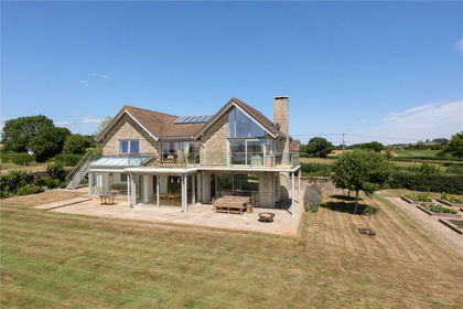
- Price
- Guide Price£1,595,000
- Size
- 5.7 acres
Added on 16/04/2026House with Land
- Price
- Guide Price£1,425,000
- Size
- 13.13 acres
Kington Magna, Gillingham, Kington Magna, Dorset SP8 England
Added on 29/04/2026Smallholding