Sunny Rigg Farm, Haltwhistle
- Land size
- 250.68 acres
Key Features
- Traditional Four-Bedroom Stone-Built Farmhouse
- Range of Modern Buildings
- Approximately 101.45 Ha (250.68 Ac) of Land
- Productive Mowing Pastures and Upland Grazing Land
- Adjacent to Hadrian's Wall
- Tourism Diversification Potential
Description
GENERAL INFORMATION
Sunny Rigg Farm is situated north of the town of Haltwhistle, located between the B6318 Military Road and Hadrian's Wall World Heritage Site.
The property occupies a desirable rural location in a historic area of the Northumberland countryside. The farm is accessible whilst benefiting from a pleasant rural setting and being situated close to the local amenities of nearby Haltwhistle.
The nearby A69 trunk road provides ready access to the larger regional cities of Newcastle and Carlisle.
Sunny Rigg Farm is an excellent example of a Northumbrian livestock farm boasting a mix of quality mowing pastures, permanent pasture and upland grazing extending to approximately 101.47 hectares (250.68 acres). The farm includes a stone-built four-bedroom farmhouse together with an excellent range of livestock buildings.
The property presents itself as a viable standalone unit but equally would appeal to existing farmers looking to expand or acquire a holding with excellent livestock buildings suited to developing cattle and sheep farming enterprises. Equally, the currently let land and an in-hand stewardship scheme may appeal to non-farming purchasers.
The location in the heart of Roman Wall country represents an ideal opportunity for purchasers to capitalise on the tourism appeal of the local area. The route of Hadrian's Wall lies immediately adjacent to the northern boundary of the property and its situation on the Military Road lies on the main tourist route.
The property is also located within the Dark Sky Park in Northumberland National Park and offers scope for the development of tourism accommodation through conversion of the traditional buildings, or the development of camping or glamping facilities, subject to obtaining the necessary consents.
SUNNY RIGG FARMHOUSE
The farmhouse at Sunny Rigg Farm comprises a traditional four-bedroom dwelling of traditional Northumbrian stone under slate construction. The property occupies a commanding position situated just to the east of the farm steading with gardens front and rear and a small croft to the south, the site of a former dwelling which would provide potential to extend the formal gardens.
The dwelling is spacious and well-appointed and would make for an ideal family home.
Accommodation briefly comprises a large kitchen with utility, two further large reception rooms and an office. On the first floor there are four spacious bedrooms and a large family bathroom.
The farmhouse lies immediately adjacent to the traditional buildings and a modern workshop, which are separate from the main livestock buildings on the holding. There is potential to develop these buildings and extend the dwelling curtilage to encompass holiday accommodation or other alternative uses, such as a home office or storage, subject to planning.
Sunny Rigg Farmhouse is a characterful home situated in a commanding location overlooking the surrounding South Tyne Valley. The property is set back from the adjacent Military Road and central to the holding.
The property is served by mains water and septic drainage. Mains electricity with additional solar panels serves the property.
Energy Performance Certificate: Farmhouse: C (Potential: B)
Council Tax Band E.
The property was constructed under planning permission from Northumberland National Park ref: 98/NP/4 and is subject to an agricultural occupancy condition.
BUILDINGS
In addition to the modern livestock buildings, there is a small range of more traditional buildings and a modern workshop building adjacent to the farmhouse. These buildings offer the purchaser the opportunity to use them in connection with the farmhouse and/or consider development potential for alternative uses without impacting the functional nature of the main livestock buildings serving the holding.
Development for tourism use, given the location close to Hadrian's Wall and its main walking routes, creates significant potential for the property.
The farm steading at Sunny Rigg is well-equipped for livestock use and includes a range of modern buildings extending to approximately 1,440 m², including a covered silage clamp with concrete walling and cattle buildings with scrape passages to an open yard muck store.
The livestock buildings complement the mowing and pasture land and provide a functional livestock unit. The main buildings are located to the north of the farmhouse, with tracked access to the main parcels of land from the steading.
LAND
The land at Sunny Rigg Farm extends to approximately 101.45 ha (250.68 ac), including the farmstead and access, and some small areas of shelterbelt woodland.
The majority of the land lies to the south of the course of Hadrian's Wall running down to the main B6318 Military Road with three parcels to the south side of the road.
The land is arranged in 17 good sized field parcels and comprises a good mix of mowing pastures, permanent pasture and upland grazing. There is approximately 16 ha (40 ac) of mowing and silage pastures with the remainder comprising permanent pasture, including rigg and furrow fields of 20 ha (50 ac) and a larger block of more marginal upland grazing to the northern section of the farm extending to approximately 65 ha (150 ac).
The land lies at an elevation of between 190m and 210m and is classified as SDA (LFA) on the Rural Land Registry.
The land is currently farmed by a neighbouring farmer under an annual grazing licence with a Mid Tier Environmental Stewardship agreement in place claimed by the vendors.
The majority of the holding is classified as Grade 5 land to the north of the Military Road and Grade 4 land to the south.
The land has been farmed to a good standard with all FYM returned to the holding historically which has led to healthy grass yields, facilitated by the ability to house stock and store muck with the equipped farm steading on the holding.
The upland grazing to the northern part of the farm provides for a diverse habitat and creates varied amenity and environmental appeal for the holding with potential for a purchaser to explore natural capital opportunities across the holding.
PLANS, AREAS AND SCHEDULES
These are based on the areas provided by HM Land Registry and Ordnance Survey and are for reference only. Although they have been carefully checked, the purchaser shall be deemed to have satisfied themselves as to the description and extent of the property. Any error, omission or misstatement shall not annul the sale nor entitle either party to compensation in respect thereof.
WAYLEAVES, EASEMENTS AND RIGHTS OF WAY
The property is sold subject to and with the benefit of all rights of way, easements and wayleaves, whether referred to in these particulars or not, including those in respect of masts, cables and services.
The property is crossed by one public right of way, running through the north-west corner of the farm and is sold subject to all such rights whether specifically referred to or not.
METHOD OF SALE
The property is offered for sale as a whole by private treaty.
SERVICES
The property benefits from mains electricity, mains water supply and private septic drainage.
GENERAL BINDING REGULATIONS (GBR) 2020
It is understood that the drainage system at Sunny Rigg Farm comprises a septic tank. Prospective purchasers should note that the system may not comply with the General Binding Regulations 2020 and it is likely that works will be required in order to ensure compliance.
Purchasers are advised to make their own enquiries and investigations as to the condition of the system and any associated requirements.
VIEWINGS
Strictly by prior appointment with the selling agents:
Richard Brown & Partners
The Office
South Bellshill
Belford
NE70 7HP
Tel:
ANTI MONEY LAUNDERING REGULATIONS (AML)
Please note that under the 2017 AML regulations the selling agents are legally required to carry out money laundering checks against purchasers.
HEALTH & SAFETY
Please be aware of the potential hazards of a working farm (especially livestock) and be as vigilant and careful as possible when making an inspection of the property.
WHAT3WORDS
///wreck.lobbed.corded
Map Location
Property details
- Tenure
- Freehold
- Council Tax Band
- Ask Agent
- Date Posted
- 2026-07-04
Market Value Analysis
Compared with 7 Farms & Smallholdings listings in North East England (250+ acres).
Utilities & Restrictions
Utilities
- Electricity
- Ask Agent
- Water
- Ask Agent
- Heating
- Ask Agent
- Broadband
- Ask Agent
- Sewerage
- Ask Agent
Rights & Restrictions
- Public Rights of Way
- Ask Agent
- Private Rights of Way
- Ask Agent
- Listed Property
- Ask Agent
- Restrictions
- Ask Agent
Listed status, conservation areas and planning constraints for this location are in the full report.
Property Features
- Accessibility
- Ask Agent
- Parking
- Ask Agent
- Garden
- Garden
Beyond the particulars: planning activity, flood history, heritage and ground risks, checked for this exact spot.
Connectivity
Broadband
Fastest speed available at this postcode
1.8 Gbps
Gigabit full fibre · available to 38% of premises
Suitable for
- 4K streaming on every screen
- Full-time home working
- Online gaming & big downloads
Mobile signal
Predicted 4G and 5G signal; indoor signal depends on building materials.
Ofcom Connected Nations postcode-level predictions. Speeds and signal are modelled, not measured, and vary between addresses and providers.
Signal is the easy part. Planning activity, flood history and protected designations here are in the full report.
Nearest Schools
Primary
- Haltwhistle Primary Academy1 mileOfsted: Outstanding
- Ages
- 3 to 11
- Pupils
- 213
- Type
- Academy sponsor led
- Greenhead Church of England Nursery and Primary School2.1 milesNo Ofsted rating
- Ages
- 4 to 11
- Pupils
- 50
- Type
- Academy converter
- Faith
- Church of England
- Gilsland CofE Primary School3.9 milesOfsted: Good
- Ages
- 3 to 11
- Pupils
- 18
- Type
- Academy converter
- Faith
- Church of England
- Henshaw Church of England Primary School4.5 milesOfsted: Good
- Ages
- 4 to 11
- Pupils
- 86
- Type
- Academy converter
- Faith
- Church of England
- Whitfield CofE Primary School6.9 milesOfsted report card · Jan 2026
- Ages
- 3 to 11
- Pupils
- 22
- Type
- Academy sponsor led
- Faith
- Church of England
Secondary
- Haydon Bridge High School9.1 milesOfsted report card · Jan 2026
- Ages
- 11 to 18
- Pupils
- 392
- Type
- Foundation school
- William Howard School11 milesNo Ofsted rating
- Ages
- 11 to 18
- Pupils
- 1,312
- Type
- Academy converter
- Samuel King's School12 milesNo Ofsted rating
- Ages
- 11 to 16
- Pupils
- 113
- Type
- Foundation school
- Bellingham Middle School and Sports College14 milesOfsted: Good
- Ages
- 9 to 13
- Pupils
- 46
- Type
- Foundation school
- Queen Elizabeth High School14 milesOfsted: Good
- Ages
- 13 to 18
- Pupils
- 1,299
- Type
- Academy converter
Distances are straight-line from the advertised location. Source: the national school registers (DfE, Welsh Government, Scottish Government) and Ofsted.
Schools are just the start: sold prices nearby, planning activity and any flood history are in the full report.
Amenities
Supermarket
GP surgery
Pharmacy
Hospital
Green space
Walking trail
Straight-line distances from the advertised location. Sources: NHS records, Geolytix supermarket locations, OS Open Greenspace and the national trails registers.
The area stacks up? Now check the location itself: planning nearby, protected designations and past flooding.
Getting Around
Nearest station
Nearest bus stop
Typical drive times
Straight-line distances from the advertised location; drive times are typical free-flow times over OpenStreetMap road data, so allow more at peak. Public transport locations from DfT NaPTAN.
Easy to reach matters. So do planning activity, flood history and ground risks: all in the full report.
Flood Risk
Environment Agency open data, checked around the advertised map pin for the listed acreage. Long-term risk counts flood defences; the planning map's flood zones do not. Provided by LandSale, not the listing agent, and not part of the agent's particulars. Risk varies across a holding, so verify before committing.
Rivers and the sea
Planning map: Flood Zone 3, about 510 metres away.
Surface water
Not at the pin: mapped about 50 metres away.
These bandings are the summary. Where this location sits on the flood maps, plus planning activity, heritage and ground risks, is in the full report.
Important notice: Information, maps and tags on this page are drawn from the advertising agent's marketing materials or generated automatically. LandSale has not verified them. Relying on these details is at your own risk, always carry out independent checks before committing to a purchase.
LandSale full disclaimer
Marketing information only - not formal particulars. The details on this website are provided for general guidance and do not constitute an offer or contract. Neither LandSale nor the advertising estate/land agent accepts responsibility for any inaccuracy.
1. Source of information
- Listing content: Core description, asking price, tenure, measurements, photographs and planning history originate from the marketing materials of the advertising estate or land agent. LandSale does not author this content and cannot guarantee its accuracy.
- Automated tags & categorisation: Property type, land-use class, acreage bands and similar labels may be applied by machine-learning models. They are intended as a helpful guide only and may not reflect the property's legal status or permitted use.
- Third-party & enriched data layers: Maps, boundary outlines, planning designations, soil reports, broadband coverage and other environmental or location-based insights are licensed from external suppliers. Such data are supplied “as is", may be incomplete or out of date and are subject to change without notice.
2. Verification required
Prospective purchasers must verify critical matters, including but not limited to planning permission, title boundaries, public rights of way, environmental constraints, acreage, services, access and VAT status, through their own inspections, specialist surveys, legal advisers and the selling agent before relying on the information or entering into any contract.
3. No warranty or liability
LandSale gives no warranty, express or implied, as to the accuracy, completeness or fitness for any particular purpose of the information displayed. LandSale shall not be liable for any loss, damage, cost or expense arising directly or indirectly from any use of or reliance on such information, save where liability may not be excluded by law.
4. Updates & feedback
If you believe any detail on this listing is inaccurate, please let us know. We will investigate and, where appropriate, update the listing or notify the agent.
© LandSale | Version 1.3 - August 2026
Listing agent
Richard Brown & Partners, Belford
The Office, South Bellshill, Bellshill, Belford, NE70 7HP
Contact Richard Brown & Partners, Belford
The Office, South Bellshill, Bellshill, Belford, NE70 7HP
View agent profileSimilar properties for sale
- Price
- Guide Price£1,800,000
- Size
- 291.83 acres
Added on 02/07/2026Farm
- Price
- Guide Price£1,800,000
- Size
- 291.83 acres
Linacres Farm, Wark, Hexham, Northumberland, NE48, Wark, Northumberland NE48 England
Added on 02/07/2026Farm
- Price
- Guide Price£1,700,000
- Size
- 1839.11 acres
Sundhope, Hawick, TD9, Hawick, Scottish Borders TD9 Scotland
Added on 29/01/2026Farm
- Price
- Offers in Excess of£1,650,000
- Size
- 165.8 acres
PARK HEAD FARM, WELTON, CARLISLE, CA5 7HL - LOT 1, Sebergham, Cumberland CA5 England
Added on 17/07/2026Farm- Price
- Offers in Excess of£1,930,000
- Size
- 213.35 acres
PARK HEAD FARM, WELTON, CARLISLE, CA5, Sebergham, Cumberland CA5 England
Added on 17/07/2026Farm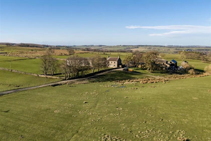
- Price
- Offers Over£2,000,000
- Size
- 262.28 acres
Middle Horsleyhope Farm, Consett, Blaydon and Consett, County Durham DH8 England
Added on 30/05/2026Farm