Linacres, Wark, Hexham
- Land size
- 291.83 acres
- Bedrooms
- 4
Key Features
- Traditional four-bedroom Farmhouse
- Ring fenced upland farm
- Range of traditional and modern buildings
- Approximately 118.10 ha (291.83 ac) of land
- Stables, horse walker and lunge pit
- Ideal lifestyle property
- Environmental, amenity and diversification potential
- JSA Youngs RPS
Description
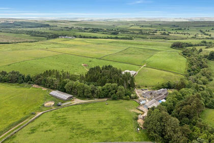
Linacres is a ring-fenced upland farm, complete with approximately 118.10 ha (291.83 ac) of land, a 4-bedroom stone built farmhouse and a well-equipped steading, comprising of both modern and traditional buildings.
The sale offers an opportunity to acquire an established North Tyne upland farm which historically carried approximately 550 ewes and 30-40 suckler cows. Noted for the quality of stock produced, Linacres is regarded as one of the foremost livestock farms in the area.
The property has also served as a base for the pre-training of racehorses as well as the training of point to pointers. The infrastructure for such remains and as such the sale offers opportunities for traditional farming and also diversification possibilities, be it equestrian use or due to nature of the traditional buildings, conversions into holiday lets or additional dwellings.
The Farmhouse
Approached via private driveway the farmhouse benefits from a prominent position within the holding. There is a separation between the modern buildings and the house ensuring the everyday workings of the farm are distinct to that of the residential element whilst the traditional buildings are attached, allowing the prospect of an extension to the main dwelling or offering scope for development.
Built from traditional stone and under a slate roof, the house benefits from four double bedrooms and two bathrooms on the first floor, with one being ensuite.
On the ground floor, the back door and everyday entrance leads from a porch to a utility/boot room, from here and accessible via a corridor there is a kitchen, a sitting room and a dining/living room. The front door opens out to a private parking area with a large lawned garden.
The kitchen; typical of any farmhouse is the hub of the house, with fitted units and an oil-fired aga providing both heat and character. The sitting room/snug is accessible from the kitchen and via an open arch, which lends itself to open plan and modern living. Benefiting from dual aspect windows, the room is light and spacious. More formal living and/or a quieter room for relaxing can be found in the living/dining room, which again benefits from plenty of natural light and a woodburning stove.
The house is double glazed throughout, with central heating via a biomass wood boiler, fueled by logs rather than chip/pellets; a ready supply of timber on the property ensures efficiency and self-sustainability. Further self-sufficiency is provided for by the private water supply and an array of solar panels; these supply electric to the grid with a monetary payment back as a result. Hot water is provided for via the boiler but also in the summer months via the solar panels. Drainage is to a private septic tank.
The Steading
Linacres steading encompasses both the new and old, with three modern livestock buildings, a range of semi modern buildings and a range of traditional buildings.
The primary modern buildings are well sized and accessible. They are all steel framed with concrete panels to sides, wooden Yorkshire boarding and sheet roofs. Two are open fronted ensuring excellent ventilation and ease of animal feeding.
The traditional buildings are made of traditional stone under slate roofs. Currently they are used for storage, informal animal housing and stabling. Their nature suggests that subject to obtaining the necessary consents that they would convert offering scope for diversification and/or an extension to the main dwelling.
The secondary modern buildings, include a range of both steel and timber framed buildings. They are ideal for their current use and provide excellent animal housing and management facilities.
Equestrian facilities on the farm include stables, lunge pit and a horse walker, all are used regularly.
Cattle handling facilities, the horse walker and the Monarch loose boxes are "fixtures" and can be removed depending on interest.
The Land
Sitting in a ring fence of (118.10 ha) 291.83 acres, there is approximately 268.24 acres of permanent pasture and circa 11 acres of woodland, the remainder being steading area and a pond.
The farm benefits from 58 acres of mowable grass land which lies immediately adjacent to the steading and/or is within easy reach of it. It forms the productive heart of the farm and is capable of producing quality fodder. The remaining grass land comprises of useful and well apportioned grazing land, with two larger areas of "fell" land, which is again good grazing ground. This land is ideal for the summering and wintering of large numbers of livestock, allowing the heart of the farm to be rested and/or cropped when necessary. In short, the farm is ideally laid out for livestock farming with its history a testament to this.
The woodland on the farm provides excellent shelter, whilst also providing an ideal of source of timber to fuel the farmhouse boiler. Additional shelter can be found via a series of natural ravines and gulleys, that shield the various streams and watercourse that run through the farm.
The farms boundaries both internal and external are stockproof and in the main they are in good condition and consist of post and wire fences and/or dry-stone walls.
The land is watered via a natural supply be it via watercourses or troughs, with the troughs serviced by a private supply. The land ranges from a high of 201m above sea level to a low of 168m, with the house/sitting at 168m.
The nature of the land, its history and its renowned capabilities show that the holding presents an ideal opportunity for a purchaser to quickly establish a commercially viable agricultural business from the farm. Furthermore, the recent decrease in stock numbers have shown that the land offers clear scope to capitalize on the environmental nature of the farm, be it amenity or monetary.
Equestrian
In recent years, the stables have been utilized as a pretraining yard by a number of noted racehorse trainers. Whilst much of this lies in the capabilities of the handler, the infrastructure at Linacres undoubtedly helped; light and airy stables, a horse walker, and a lunge pit all played a significant part in the horses' education and fitness.
The infrastructure, much which are of fittings, will be available if required and as they present an ideal opportunity for any equestrians who may wish to establish an equine facility.
ENVIRONMENTAL SCHEMES
The land is currently entered into both a Mid Tier Stewardship agreement and a Higher Tier (woodland) Stewardship agreement, with an annual income generated of approximately £14,000 per year. These agreements terminate on 31/12/2028, they can be transferred and/or terminated subject to agreement.
If transferred, the MT and HT stewardship payments will be apportioned from the date of completion to the end of the scheme year. The buyer will give an undertaking to abide by the scheme rules for that period, and/or until the agreement is transferred if applicable. The costs of transferring or terminating the agreements will be borne by the purchaser being £400 plus VAT. There is an active Sustainable Farming Incentive agreement on the farm, this is non transferrable and will be terminated at the appropriate time.
LOCATION
Linacres is located in the county of Northumberland, within its famed National Park, lying approximately 3.4 miles to the north west of the village of Wark. Bellingham is approximately 5.7 miles to the north.
Wark and Bellingham are noted North Tyne villages with an array of local shops, pubs and hotels. Bellingham has a medical surgery, whilst both offer educational facilities. Sitting in the heart of North Tyne they are both popular for day trippers and residents alike with a strong sense of community as a result.
The regions major town of Hexham, lies 16 miles to the south. Hexham offers an extensive range of local shops, as well as national supermarkets, excellent schooling and a range of professional and leisure services. There is a railway station at Hexham as well as access to the A69.
Newcastle upon Tyne is 33 miles to the south east, it provides extensive opportunities be it shopping, services, professional needs, as well catering for any cultural and/or recreational requirements.
In terms of wider connectivity and general transport links, there is public transport available at Wark, train stations at Hexham and Newcastle, excellent road links via the A69, as well as the highly accessible Newcastle International Airport.
What3Words: ///statement.they.pushing
ACCESS
Access to the property is via unmade farm road which adjoins the public highway.
DESIGNATIONS
The property is within the Northumberland National Park.
GENERAL REMARKS & STIPULATIONS
Method of Sale
The property is to be offered for sale by Private Treaty.
Areas
The areas and measurements stated have been assessed in accordance with OS data and digital mapping. Interested parties should though satisfy themselves in this regard.
Sporting Rights and Mineral Rights
Included in the sale in so far as they are owned.
Tenure
Freehold with Vacant Possession on Completion.
Services
The property benefits from a private water supply (borehole) and private drainage. Electricity is via a mains supply in addition there are solar panels which generate an income via a feed in tariff and supplement the cost of electricity. They also provide hot water to the house when required. Central heating provided by a biomass (wood) boiler.
Rates and Energy Performance Certificate (EPC)
The farmhouse is banded as E for Council Tax purposes and has an EPC rating of C.
Wayleaves/Easements
The property is sold subject to all rights including rights of way, whether public or private, rights of light, support, drainage, water and electricity supplies and other rights, obligations and easements, quasi easements and restrictive covenants and all existing and proposed wayleaves for masts, pylons, stays, cables, drains and water, gas and other pipes, whether or not constituted in the title deeds or referred to in these particulars.
There is a bridleway which crosses the property.
Anti Money Laundering Regulations
Prospective Buyers should be aware that in the event that they are successful, they will be required to provide us with documents in relation to Money Laundering Regulations, one being photographic ID, i.e. driving license or passport and the other being a utility
Map Location
Property details
- Tenure
- Freehold
- Council Tax Band
- Ask Agent
- Date Posted
- 2026-07-02
Market Value Analysis
Compared with 7 Farms & Smallholdings listings in North East England (250+ acres).
Utilities & Restrictions
Utilities
- Electricity
- Ask Agent
- Water
- Ask Agent
- Heating
- Ask Agent
- Broadband
- Ask Agent
- Sewerage
- Ask Agent
Rights & Restrictions
- Public Rights of Way
- Ask Agent
- Private Rights of Way
- Ask Agent
- Listed Property
- Ask Agent
- Restrictions
- Ask Agent
Listed status, conservation areas and planning constraints for this location are in the full report.
Property Features
- Accessibility
- Ask Agent
- Parking
- Parking Available
- Garden
- Garden
Beyond the particulars: planning activity, flood history, heritage and ground risks, checked for this exact spot.
Connectivity
Broadband
Fastest speed available at this postcode
5 Mbps
Under 10 Mbps here
Suitable for
- Basic browsing & email
Mobile signal
Predicted 4G and 5G signal; indoor signal depends on building materials.
Ofcom Connected Nations postcode-level predictions. Speeds and signal are modelled, not measured, and vary between addresses and providers.
Signal is the easy part. Planning activity, flood history and protected designations here are in the full report.
Nearest Schools
Primary
- Wark Church of England Primary School3.1 milesOfsted report card · Jun 2026
- Ages
- 3 to 11
- Pupils
- 69
- Type
- Academy converter
- Faith
- Church of England
- Bellingham Primary School3.4 milesOfsted: Good *
- Ages
- 4 to 8
- Pupils
- 64
- Type
- Foundation school
- Greenhaugh Primary School5.7 milesNo Ofsted rating
- Ages
- 4 to 11
- Pupils
- 13
- Type
- Community school
- Chollerton Church of England Aided First School7.1 milesOfsted: Good
- Ages
- 2 to 9
- Pupils
- 31
- Type
- Voluntary aided school
- Faith
- Church of England
- Newbrough Church of England Primary School7.8 milesOfsted report card · Mar 2026
- Ages
- 2 to 11
- Pupils
- 65
- Type
- Academy converter
- Faith
- Church of England
Secondary
- Bellingham Middle School and Sports College3.4 milesOfsted: Good
- Ages
- 9 to 13
- Pupils
- 46
- Type
- Foundation school
- Haydon Bridge High School8.8 milesOfsted report card · Jan 2026
- Ages
- 11 to 18
- Pupils
- 392
- Type
- Foundation school
- Queen Elizabeth High School11 milesOfsted: Good
- Ages
- 13 to 18
- Pupils
- 1,299
- Type
- Academy converter
- St Joseph's Catholic Middle School, Hexham11 milesNo Ofsted rating
- Ages
- 9 to 13
- Pupils
- 168
- Type
- Academy converter
- Faith
- Roman Catholic
- Hexham Middle School12 milesNo Ofsted rating
- Ages
- 9 to 13
- Pupils
- 619
- Type
- Academy converter
* Latest graded judgement covers quality of education only; no overall grade was issued under the 2024-25 inspection framework.
Distances are straight-line from the advertised location. Source: the national school registers (DfE, Welsh Government, Scottish Government) and Ofsted.
Schools are just the start: sold prices nearby, planning activity and any flood history are in the full report.
Amenities
Supermarket
GP surgery
Pharmacy
Hospital
Walking trail
Straight-line distances from the advertised location. Sources: NHS records, Geolytix supermarket locations, OS Open Greenspace and the national trails registers.
The area stacks up? Now check the location itself: planning nearby, protected designations and past flooding.
Getting Around
Nearest station
Nearest bus stop
Typical drive times
Straight-line distances from the advertised location; drive times are typical free-flow times over OpenStreetMap road data, so allow more at peak. Public transport locations from DfT NaPTAN.
Easy to reach matters. So do planning activity, flood history and ground risks: all in the full report.
Flood Risk
Environment Agency open data, checked around the advertised map pin for the listed acreage. Long-term risk counts flood defences; the planning map's flood zones do not. Provided by LandSale, not the listing agent, and not part of the agent's particulars. Risk varies across a holding, so verify before committing.
Rivers and the sea
Not at the pin: mapped about 30 metres away.
Planning map: Flood Zone 3, about 40 metres away.
Surface water
Not at the pin: mapped about 20 metres away.
These bandings are the summary. Where this location sits on the flood maps, plus planning activity, heritage and ground risks, is in the full report.
Important notice: Information, maps and tags on this page are drawn from the advertising agent's marketing materials or generated automatically. LandSale has not verified them. Relying on these details is at your own risk, always carry out independent checks before committing to a purchase.
LandSale full disclaimer
Marketing information only - not formal particulars. The details on this website are provided for general guidance and do not constitute an offer or contract. Neither LandSale nor the advertising estate/land agent accepts responsibility for any inaccuracy.
1. Source of information
- Listing content: Core description, asking price, tenure, measurements, photographs and planning history originate from the marketing materials of the advertising estate or land agent. LandSale does not author this content and cannot guarantee its accuracy.
- Automated tags & categorisation: Property type, land-use class, acreage bands and similar labels may be applied by machine-learning models. They are intended as a helpful guide only and may not reflect the property's legal status or permitted use.
- Third-party & enriched data layers: Maps, boundary outlines, planning designations, soil reports, broadband coverage and other environmental or location-based insights are licensed from external suppliers. Such data are supplied “as is", may be incomplete or out of date and are subject to change without notice.
2. Verification required
Prospective purchasers must verify critical matters, including but not limited to planning permission, title boundaries, public rights of way, environmental constraints, acreage, services, access and VAT status, through their own inspections, specialist surveys, legal advisers and the selling agent before relying on the information or entering into any contract.
3. No warranty or liability
LandSale gives no warranty, express or implied, as to the accuracy, completeness or fitness for any particular purpose of the information displayed. LandSale shall not be liable for any loss, damage, cost or expense arising directly or indirectly from any use of or reliance on such information, save where liability may not be excluded by law.
4. Updates & feedback
If you believe any detail on this listing is inaccurate, please let us know. We will investigate and, where appropriate, update the listing or notify the agent.
© LandSale | Version 1.3 - August 2026
Listing agent
Richard Brown & Partners, Belford
The Office, South Bellshill, Bellshill, Belford, NE70 7HP
Contact Richard Brown & Partners, Belford
The Office, South Bellshill, Bellshill, Belford, NE70 7HP
View agent profileSimilar properties for sale
- Price
- Guide Price£1,800,000
- Size
- 291.83 acres
Linacres Farm, Wark, Hexham, Northumberland, NE48, Wark, Northumberland NE48 England
Added on 02/07/2026Farm
- Price
- Offers Over£1,650,000
- Size
- 250.68 acres
Sunny Rigg Farm, Haltwhistle, Haltwhistle, Northumberland NE49 England
Added on 04/07/2026Farm
- Price
- Guide Price£1,700,000
- Size
- 1839.11 acres
Sundhope, Hawick, TD9, Hawick, Scottish Borders TD9 Scotland
Added on 29/01/2026Farm
- Price
- Offers Over£2,250,000
- Size
- 329.02 acres
Middle Horsleyhope Farm, Consett, Muggleswick, County Durham DH8 England
Added on 30/05/2026Livestock Farm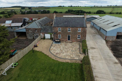
- Price
- Offers Over£2,150,000
- Size
- 175.41 acres
Slealands Farm, Longtown, Carlisle, Cumbria, CA6, Arthuret, Cumberland CA6 England
Added on 20/08/2026Farm- Price
- Offers Over£2,000,000
- Size
- 262.28 acres
Middle Horsleyhope Farm, Consett, Blaydon and Consett, County Durham DH8 England
Added on 30/05/2026Farm