Land at East Court Farm, Chalk, Gravesend, Kent
- Land size
- 275.48 acres
Key Features
- 53.49 acres of productive arable land comprised within a single field parcel
- 221.99 acres of traditional North Kent grazing marsh predominantly comprised within a ring-fence and divided by drainage ditches, with a separate parcel to the north
- Agri-Environmental Scheme income opportunities
- Long road frontage and easy access off Lower Higham Road
- In all approximately 275.48 acres (111.48 hectares)
- For sale as a whole or in 2 Lots
- Lot 1: 53.49 acres - Guide Price £590,000
- Lot 2: 221.99 acres - Guide Price £1,160,000
- As a Whole 275.48 acres - Guide Price £1,750,000
Description
The Land at East Court Farm occupies a rural yet accessible position just outside the village of Chalk, a short distance east of the town of Gravesend, approximately two miles northwest of the village of Higham on the border between the North Kent Plain and Thames Marshes. The nearby towns of Gravesend, Northfleet and Dartford lie within the wider local area and collectively provide a comprehensive range of facilities, amenities, as well as regular high speed rail connections to Central London via Ebbsfleet International.
The Land at East Court Farm is principally comprised within two distinct blocks, situated on the north and south sides of Lower Higham Road.
Lot 1: 53.49 acres (21.65 hectares) - £590,000
A single block of Grade II farmland in arable production. The land is generally level, sloping gently away to the north. Soils are described as loamy drift soils over chalk and suitable for early cropping. The land is partially cropped with oilseed (OSR) for the 2026 cropping year, with the balance of the land being in legume fallow.
Gated access is available directly off Lower Higham Road.
Lot 2: 221.99 acres (89.83 hectares) - £1,160,000
A substantial block of traditional grazing marsh, typical of North Kent. The land is generally level and principally comprised within one block, serviced by a central land way leading from Lower Higham Road. The land is subdivided by a series of internal drainage ditches, into several useful field parcels. Gated access is available directly off Lower Higham Road.
Lot 2 is crossed by two public footpaths, one leads north along the landway from Lower Higham Road, the other crosses the land to the southeastern corner.
A single 15.05-acre parcel is situated to the north, dissected from the main holding by a railway line. This is accessed from Queens Farm Road, across the railway and thence along a landway to the south and via neighbouring land.
Soils are described as deep stoneless clayey soils and can be prone to seasonal waterlogging.
Please see the Property Particulars for further information on maps & plans, public rights of way, access, sporting, timber & mineral rights, tenure, Lower Thames Crossing, Agri-Environmental Schemes etc.
Guide Prices:
Lot 1: 53.49 acres - £590,000
Lot 2: 221.99 acres - £1,160,000
Whole 275.48 acres - £1,750,000
Map Location
Property details
- Tenure
- Freehold
- Council Tax Band
- Ask Agent
- Date Posted
- 2026-04-22
Market Value Analysis
Compared with 7 Farmland & Pasture listings in South East England (100+ acres).
Utilities & Restrictions
Utilities
- Electricity
- Ask Agent
- Water
- Ask Agent
- Heating
- Ask Agent
- Broadband
- Ask Agent
- Sewerage
- Ask Agent
Rights & Restrictions
- Public Rights of Way
- Ask Agent
- Private Rights of Way
- Ask Agent
- Listed Property
- Ask Agent
- Restrictions
- Ask Agent
Property Features
- Accessibility
- Ask Agent
- Parking
- Ask Agent
- Garden
- Ask Agent
Important notice: Information, maps and tags on this page are supplied by the advertising agent or generated automatically. LandSale has not verified them. Relying on these details is at your own risk, always carry out independent checks before committing to a purchase.
LandSale full disclaimer
Marketing information only - not formal particulars. The details on this website are provided for general guidance and do not constitute an offer or contract. Neither LandSale nor the advertising estate/land agent accepts responsibility for any inaccuracy.
1. Source of information
- Agent-supplied content: Core description, asking price, tenure, measurements, photographs and planning history are uploaded by the appointed agent, who remains solely responsible for their accuracy.
- Automated tags & categorisation: Property type, land-use class, acreage bands and similar labels may be applied by machine-learning models. They are intended as a helpful guide only and may not reflect the property's legal status or permitted use.
- Third-party & enriched data layers: Maps, boundary outlines, planning designations, soil reports, broadband coverage and other environmental or location-based insights are licensed from external suppliers. Such data are supplied “as is", may be incomplete or out of date and are subject to change without notice.
2. Verification required
Prospective purchasers must verify critical matters, including but not limited to planning permission, title boundaries, public rights of way, environmental constraints, acreage, services, access and VAT status, through their own inspections, specialist surveys, legal advisers and the selling agent before relying on the information or entering into any contract.
3. No warranty or liability
LandSale gives no warranty, express or implied, as to the accuracy, completeness or fitness for any particular purpose of the information displayed. LandSale shall not be liable for any loss, damage, cost or expense arising directly or indirectly from any use of or reliance on such information, save where liability may not be excluded by law.
4. Updates & feedback
If you believe any detail on this listing is inaccurate, please let us know. We will investigate and, where appropriate, update the listing or notify the agent.
© LandSale | Version 1.2 - January 2026
Listing agent
BTF Partnership, Heathfield
Euston House 82a High Street, Heathfield, TN21 8JD
Contact BTF Partnership, Heathfield
Euston House 82a High Street, Heathfield, TN21 8JD
View agent profileSimilar properties for sale
- Price
- Offers in Excess of£2,000,000
Pratling Street, Aylesford, Aylesford, Kent ME20 7DU England
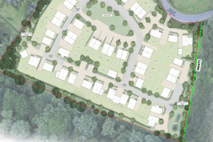
Added on 07/07/2026Development Land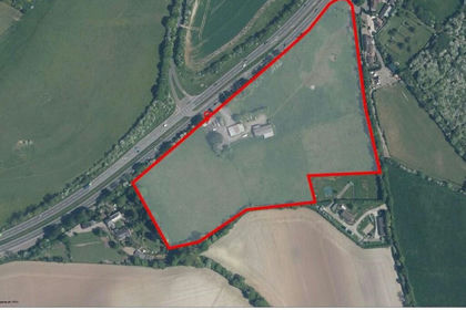
- Price
- Offers in Excess of£1,750,000
- Size
- 13 acres
Added on 10/06/2026Commercial Land
- Price
- Guide Price£1,250,000
- Size
- 66.32 acres
Added on 02/05/2026Farmland
- Price
- Offers in Region of£1,750,000
- Size
- 13.5 acres
Woods Farm, Woodham Road, Wickford, SS11 7QU, Rettendon, Essex SS11 7QU England
Added on 18/06/2026Agricultural Land
- Price
- Guide Price£1,275,000
- Size
- 138.92 acres
Added on 20/07/2026Farm
- Price
- Guide Price£1,950,000
- Size
- 121.16 acres
Little Cooting Farm, Adisham, Canterbury, Kent, Adisham, Kent CT3 3JQ England
Added on 18/06/2026Farmland
- Price
- £2,000,000
- Size
- 44 acres
Chertsey Lane, Chertsey, TW18, Runnymede and Weybridge, Surrey TW18 3LP England
Added on 22/04/2026Grazing Land
- Price
- £1,580,000
- Size
- 185.56 acres
Hintlesham and Chattisham, Ipswich, IP8, Chattisham, Suffolk IP8 3PX England
Added on 17/07/2026Farmland
- Price
- Offers in Region of£1,250,000
- Size
- 4.4 acres
Added on 25/06/2026Development Land
- Price
- Guide Price£2,375,000
- Size
- 220 acres
Willington, Bedford, Bedfordshire, Willington, Bedford MK44 3PR England
Added on 15/07/2026Farm