Upton Cross, Liskeard
- Land size
- 1.2 acres
- Bedrooms
- 3
- Bathrooms
- 2
Description
THE STARGAZERS DREAM.
A fascinating opportunity to purchase a detached country residence with the Caradon Observatory and associated outbuildings, set amidst the beautifully romantic landscape of the eastern foothills of Bodmin Moor. A truly unique proposition with immense potential. About 1154 sq ft, 24' Sitting/Dining Room, Kitchen, 3 Bedrooms (2 Ensuite), Family Bath/Shower Room, Balcony, Parking and Garden, Wheelchair Accessible, Observatory Building, Studio/Games Room, Workshop and Store. About 1.20 Acres.
OPEN MOORLAND 1 MILE, LISKEARD 7 MILES, LAUNCESTON 9 MILES, LOOE AND THE BEACH 15 MILES
Location - In an enviable setting on the eastern foothills of Bodmin Moor, this setting is awash with scenic beauty and an abundance of wildlife. From the property one can observe stunning views over the beautiful countryside of South East Cornwall. Bodmin Moor has been designated an International Dark Sky Landscape with recent light readings showing the quality of the night sky over the moor as among the best in the world, Mercury Lodge lies within the 2 mile buffer zone of this designated area. The wide expanse of Bodmin Moor is easily accessible and provides excellent opportunities for equestrians and those with outdoor interests.
The property is situated on the outskirts of the popular village of Upton Cross, with amenities including a renowned primary school (rated "outstanding" by Ofsted) and a bus route which links the towns of Liskeard and Launceston. Nearby is the Caradon Inn public house and the internationally renowned Sterts open air theatre. Liskeard provides access to a substantial array of amenities including a main line railway station (Plymouth to London Paddington 3 hours).
The University city of Plymouth is easily accessible and boasts a comprehensive range of premier retail outlets, entertainment and dining establishments set against the back drop of the historic waterside areas of The Hoe and the Barbican.
In addition the renowned St Mellion International Golf Resort and the South Cornish Coast at Whitsand Bay is within easy driving distance. The wide expanse of Bodmin Moor with notable features including The Cheesewring and the Hurlers are within walking distance, with open moorland accessible only about 1 mile from the property.
Description - MERCURY LODGE comprises a detached south facing country residence in an exclusive setting of just 4 (inc this) and benefits from full double glazing and oil fired central heating. The property has been designed to enable wheelchair accessibility with a ground floor bedroom and ensuite shower room.
The accommodation extends to about 1154 sq ft and briefly comprises - 24' sitting/dining room with dual aspect has a Birch laminate floor and French doors with superb views across open country. In turn leading to the fitted kitchen and ground floor ensuite bedroom. At first floor level the principal bedroom has an ensuite shower room/wc and door opening to the balcony again with wonderful views, there is also a further bedroom together with a family bath/shower room. All of the bedrooms are generous double rooms and there is eaves storage.
CARADON OBSERVATORY - (About 600 sq ft) - with four domes and well suited for professional or enthusiast use capitalising on the Dark Sky status. the Caradon Observatory can be found on Facebook.
An occupancy restriction states "The occupation of Mercury Lodge (as shown on Approved Plan 1385/16) shall be limited to the owner or manager/site supervisor of the Caradon Observatory or a widow or widower of such a person, and to any resident dependants."
VARIOUS OUTBUILDINGS - Studio/Games Room with cloakroom/wc and kitchenette (about 400 sq ft) which has been used as a classroom in association with the observatory this building might be considered suitable for use as an annexe, holiday let, work from home or some form of creatives space - subject to any consents that may be required. In addition there is a Shed, Open fronted Workspace, Workshop and Garden Store.
Outside - The driveway has a right of way over in favour of two neighbouring residential properties. There is ample provision for private and level parking. A large paved patio immediately adjoins the property with a sunny south aspect and fabulous views. The driveway gives convenient access to all of the outbuildings previously described. In addition there is a paddock which has in recent years been allowed to rewild however this could perhaps be used for grazing or smallholding purposes. Within the paddock there is a fascinating feature of granite standing stones created by our client. The property extends to about 1.20 acres.
Epc Rating - C, Council Tax Band - C - SERVICES - Mains water and electricity. Private drainage (1 for house and 1 for observatory). Broadband - Superfast available. Mobile coverage - Indoor - Limited, Outdoor - Likely.
Directions - Search for Caradon Observatory on Google Maps.
Map Location
Property details
- Tenure
- Freehold
- Council Tax Band
- Ask Agent
- Date Posted
- 2026-01-28
Market Value Analysis
Compared with 1,624 Homes with Land listings in South West England (1+ acres).
Utilities & Restrictions
Utilities
- Electricity
- Ask Agent
- Water
- Ask Agent
- Heating
- Ask Agent
- Broadband
- Ask Agent
- Sewerage
- Ask Agent
Rights & Restrictions
- Public Rights of Way
- Ask Agent
- Private Rights of Way
- Ask Agent
- Listed Property
- Ask Agent
- Restrictions
- Ask Agent
Listed status, conservation areas and planning constraints for this location are in the full report.
Property Features
- Accessibility
- Ask Agent
- Parking
- Parking Available
- Garden
- Garden
Beyond the particulars: planning activity, flood history, heritage and ground risks, checked for this exact spot.
Connectivity
Broadband
Fastest speed available at this postcode
1.8 Gbps
Gigabit full fibre · available to 58% of premises
Suitable for
- 4K streaming on every screen
- Full-time home working
- Online gaming & big downloads
Fixed wireless access may also be an option here.
Mobile signal
Predicted 4G and 5G signal; indoor signal depends on building materials.
Ofcom Connected Nations postcode-level predictions. Speeds and signal are modelled, not measured, and vary between addresses and providers.
Signal is the easy part. Planning activity, flood history and protected designations here are in the full report.
Nearest Schools
Primary
- Upton Cross Academy1 mileNo Ofsted rating
- Ages
- 3 to 11
- Pupils
- 113
- Type
- Academy converter
- Coads Green Primary School2.1 milesOfsted: Good
- Ages
- 3 to 11
- Pupils
- 29
- Type
- Academy converter
- Pensilva Primary School2.3 milesOfsted report card · Feb 2026
- Ages
- 4 to 11
- Pupils
- 101
- Type
- Community school
- Darite Primary Academy3 milesOfsted: Good
- Ages
- 4 to 11
- Pupils
- 35
- Type
- Academy converter
- St Cleer Primary Academy3.9 milesOfsted: Good
- Ages
- 3 to 11
- Pupils
- 242
- Type
- Academy converter
Secondary
- Callington Community College5.4 milesOfsted: Good
- Ages
- 11 to 18
- Pupils
- 887
- Type
- Academy converter
- Liskeard School and Community College5.7 milesNo Ofsted rating
- Ages
- 11 to 18
- Pupils
- 1,115
- Type
- Academy converter
- Launceston College7 milesOfsted: Good
- Ages
- 11 to 18
- Pupils
- 1,205
- Type
- Academy converter
- Tavistock College12 milesOfsted: Requires improvement
- Ages
- 11 to 18
- Pupils
- 1,200
- Type
- Academy converter
- Looe Community Academy12 milesOfsted report card · Feb 2026
- Ages
- 11 to 16
- Pupils
- 513
- Type
- Academy converter
Distances are straight-line from the advertised location. Source: the national school registers (DfE, Welsh Government, Scottish Government) and Ofsted.
Schools are just the start: sold prices nearby, planning activity and any flood history are in the full report.
Amenities
Supermarket
GP surgery
Pharmacy
Hospital
Green space
Straight-line distances from the advertised location. Sources: NHS records, Geolytix supermarket locations, OS Open Greenspace and the national trails registers.
The area stacks up? Now check the location itself: planning nearby, protected designations and past flooding.
Getting Around
Nearest station
Nearest bus stop
Typical drive times
Straight-line distances from the advertised location; drive times are typical free-flow times over OpenStreetMap road data, so allow more at peak. Public transport locations from DfT NaPTAN.
Easy to reach matters. So do planning activity, flood history and ground risks: all in the full report.
Flood Risk
Environment Agency open data, checked around the advertised map pin for the listed acreage. Long-term risk counts flood defences; the planning map's flood zones do not. Provided by LandSale, not the listing agent, and not part of the agent's particulars. Risk varies across a holding, so verify before committing.
Rivers and the sea
Planning map: Flood Zone 1.
Surface water
These bandings are the summary. Where this location sits on the flood maps, plus planning activity, heritage and ground risks, is in the full report.
Important notice: Information, maps and tags on this page are drawn from the advertising agent's marketing materials or generated automatically. LandSale has not verified them. Relying on these details is at your own risk, always carry out independent checks before committing to a purchase.
LandSale full disclaimer
Marketing information only - not formal particulars. The details on this website are provided for general guidance and do not constitute an offer or contract. Neither LandSale nor the advertising estate/land agent accepts responsibility for any inaccuracy.
1. Source of information
- Listing content: Core description, asking price, tenure, measurements, photographs and planning history originate from the marketing materials of the advertising estate or land agent. LandSale does not author this content and cannot guarantee its accuracy.
- Automated tags & categorisation: Property type, land-use class, acreage bands and similar labels may be applied by machine-learning models. They are intended as a helpful guide only and may not reflect the property's legal status or permitted use.
- Third-party & enriched data layers: Maps, boundary outlines, planning designations, soil reports, broadband coverage and other environmental or location-based insights are licensed from external suppliers. Such data are supplied “as is", may be incomplete or out of date and are subject to change without notice.
2. Verification required
Prospective purchasers must verify critical matters, including but not limited to planning permission, title boundaries, public rights of way, environmental constraints, acreage, services, access and VAT status, through their own inspections, specialist surveys, legal advisers and the selling agent before relying on the information or entering into any contract.
3. No warranty or liability
LandSale gives no warranty, express or implied, as to the accuracy, completeness or fitness for any particular purpose of the information displayed. LandSale shall not be liable for any loss, damage, cost or expense arising directly or indirectly from any use of or reliance on such information, save where liability may not be excluded by law.
4. Updates & feedback
If you believe any detail on this listing is inaccurate, please let us know. We will investigate and, where appropriate, update the listing or notify the agent.
© LandSale | Version 1.3 - August 2026
Listing agent
Scott Parry Associates, Cornwall
TAMAR VIEW NURSERIES Carkeel, Saltash, PL12 6PH
Contact Scott Parry Associates, Cornwall
TAMAR VIEW NURSERIES Carkeel, Saltash, PL12 6PH
View agent profileSimilar properties for sale
- Price
- Offers Over£500,000
Stable Barn, Darley, Liskeard, Cornwall, PL14, Linkinhorne, Cornwall PL14 England
Added on 26/09/2026Barn Conversion
- Price
- Offers in Excess of£425,000
- Size
- 1 acres
Rilla Mill, Callington, Cornwall, PL17, Linkinhorne, Cornwall PL17 England
Added on 15/10/2026Cottage
- Price
- £525,000
- Size
- 5 acres
Linkinhorne, Callington, Cornwall, PL17, Linkinhorne, Cornwall PL17 England
Added on 13/05/2026House with Land
- Price
- Guide Price£550,000
- Size
- 0.24 acres
Egypt, Callington, Cornwall, PL17, South Hill, Cornwall PL17 England
Added on 23/05/2026Barn Conversion
- Price
- Guide Price£550,000
- Size
- 1.09 acres
Darite, Liskeard, Cornwall, PL14, St. Cleer, Cornwall PL14 England
Added on 27/07/2026Equestrian property
- Price
- Guide Price£525,000
Added on 28/05/2026Barn Conversion
- Price
- Guide Price£395,000
- Size
- 1.9 acres
DEVELOPMENT SITE FOR 14 DWELLINGS, Callington, Cornwall, PL17, Callington, Cornwall PL17 England
Added on 07/10/2026Development Land
- Price
- Guide Price£385,000
Added on 21/07/2026Barn Conversion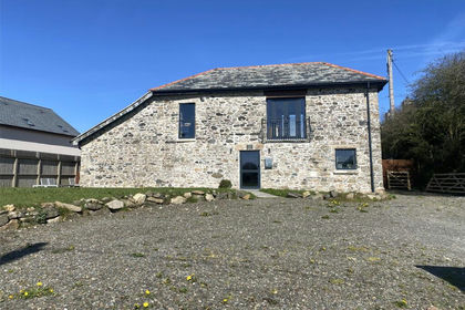 Added on 29/01/2026Barn Conversion
- Price
- Offers in Excess of£500,000
- Size
- 0.91 acres
Liskeard Enterprise Centre, Station Road, Liskeard, Cornwall, PL14, Liskeard, Cornwall PL14 England
Added on 29/01/2026Development Land