Fenland Manor Commercial Buildings and Land, PE12
Description
LOCATION
** Substantial Victorian country house set in mature established grounds totalling approximately 2.03 acres (STS). This elegant 19th Century country house has spacious accommodation including 3 large reception rooms, kitchen, ground floor annexe, 4/5 bedrooms, shower room and bathroom. The versatile accommodation is traditionally presented offering some scope for updating as required **
The property is situated adjacent to commercial premises and the Fenland Airfield along Jekils Bank. From Spalding proceed along the B1165 Austendyke Road in an easterly direction continuing into Hurdletree Bank and on to Ravens Bank. At Whaplode St Catherine turn right into Cranesgate South, continue to the 'T' junction with Jekils Bank, turn right and the property is situated on the left-hand side before the Fenland Airfield.
DESCRIPTION
Substantial Victorian country property set in mature established grounds totalling approximately 1.20 acres (STS). This elegant 19th Century country house has spacious accommodation including 3 large reception rooms, kitchen, ground floor Annexe, 4/5 bedrooms, shower room and bathroom. The versatile accommodation is traditionally presented offering some scope for updating as required.
ACCOMMODATION
This substantial Victorian former farmhouse has:
ARCHED FRONT ENTRANCE PORCH
Cupboard housing electricity meters, tiled floor, part glazed front entrance door with 'Lion' door knocker into:
RECEPTION HALL
24' 7" x 7' 10" (7.5m x 2.4m) Coat hooks, telephone point, radiator, picture rail, staircase off, doors arranged off to:
DRAWING ROOM
18' 0" x 14' 1" (5.5m x 4.3m) An elegant room with picture rail, ceiling rose, dual aspect, 2 radiators.
SITTING ROOM
14' 1" x 15' 1" (4.3m x 4.6m) Fireplace with log burner and timber mantle, 2 radiators, TV point, picture rail, dual aspect.
DINING ROOM
15' 1" x 18' 0" (4.6m x 5.5m) Dual aspect, radiator, picture rail, built-in shelved store cupboards.
KITCHEN
11' 9" x 8' 6" (3.6m x 2.6m) plus arched recess (with space for refrigerator). Range of oak style base cupboards and drawers, eye level wall cupboards, intermediate wall tiling, one and a half bowl single drainer sink unit with mixer tap, fitted breakfast bar, telephone point, electric cooker point, glazed display cabinets.
REAR HALLWAY (CONNECTING WITH THE GROUND FLOOR ANNEXE)
External entrance door.
UTILITY/REAR LOBBY
10' 2" x 8' 2" (3.1m x 2.5m) Plumbing and space for washing machine, shelving, rear staircase to the first floor, external entrance door (the staircase is included within the room measurement).
BATHROOM
10' 2" x 6' 10" (3.1m x 2.1m) Three piece suite comprising panelled bath, wash hand basin with vanity splashback and mirror over, low level WC, fully tiled walls, shaver point, radiator.
From the Rear Hallway a door connects to:
Ground Floor Annexe
ANNEXE KITCHEN
8' 10" x 6' 2" (2.7m x 1.9m) Fitted base cupboards and drawers, wall units, worktops with inset double drainer sink unit, electric cooker point, plumbing and space for washing machine. Walk in Store Room.
BED/SITTING ROOM
13' 5" x 9' 6" (4.1m x 2.9m) TV point, radiator, wall light points, coved and textured ceiling, door to the front garden.
EN-SUITE SHOWER ROOM
5' 5" x 5' 8" (1.66m x 1.74m) Fully tiled floor and walls, fitted three piece suite comprising Newlec shower, wash hand basin, low level WC, extractor fan, coved and textured ceiling.
From the Main Reception Hall the staircase rises to:
FIRST FLOOR LANDING
Doors arranged off to:
BEDROOM 1
15' 1" x 18' 0" (4.6m x 5.5m) Dual aspect, hot water cylinder with immersion heater, picture rail.
BEDROOM 2
14' 1" x 18' 0" (4.3m x 5.5m) Dual aspect, coved cornice.
BEDROOM 3
14' 1" x 15' 1" (4.3m x 4.6m) Coved cornice.
BEDROOM 4
12' 1" x 8' 6" (3.7m x 2.6m) Fitted wardrobe with shelving to the side and overhead cupboards over the bed recess.
REAR LANDING/BEDROOM 5
12' 1" x 6' 10" (3.7m x 2.1m) Access to large roof space with windows, staircase leading down to the rear lobby.
Also from the Landing a door gives access into:
SHOWER ROOM
8' 2" x 9' 6" (2.5m x 2.9m) Shower cubicle, pedestal wash hand basin with tiled splashback and vanity mirror, low level WC, electric shaver point.
EXTERIOR
The property is approached between twin gates with a decorative shaped wall to a tree lined driveway opening on to an extensive driveway and multiple parking area with access to:
ATTACHED DOUBLE GARAGE
22' 3" x 22' 3" (6.8m x 6.8m) Sliding door, cold water tap, recess housing the oil fired central heating boiler serving the domestic hot water system and part central heating system.
THE GARDENS
The house is approached along a sweeping gravelled driveway from Jekils Bank leading to a circular gravelled area in front of the house with a central garden laid to lawn with a flower bed and specimen Cedar tree. Shrubbery to the southern side offers privacy.
The garden to the north is laid to lawn with further sunken lawn and shrubbery to the west side of the main drive.
The gardens to the east are established with lawns, stocked borders and trees.
COMMERCIAL BUILDINGS & YARD
DETAILS OF THE BUILDINGS & YARD (Measurements/Areas reflect Gross Internal and are approximate/for guidance only)
WORKSHOP NO. 1 (EAST):
12.6m x 27m - 340.2m2 (3660 ft2) Built of brick with steel trusses and asbestos roof incorporating a corner office
WORKSHOP 1A EAST (REAR):
11.70m X 11.7m - 136.87m2 (1472 ft2) of steel and profile construction.
ADJOINING LEAN TO (EAST SIDE):
5.4m x 27.0m (Internal Overall) - 145.80m2 (1568 ft2) built of brick with asbestos roof and sub-divided into various sections.
WORKSHOP NO. 2 (WEST):
20.40m x 17.14m - 349.65m2 (3762 ft2) built of part-brick, asbestos roof and incorporating inspection pit.
REAR EXTENSION TO NO. 2 WORKSHOP:
6.45m x 8.82m + 8.25m x 7.48m - Total 118.59 m2 (1276 ft2) with rear entrance door
EXTERNAL FRONT HARDCORED DISPLAY AREA:
With surface water drainage incorporated including extensive display areas and long frontage to Jekils Bank, fenced and gated.
OCCUPATIONS
Building 1 and 1a: These are let to three different occupiers with a cumulative annual rent of £10,200. Two of the occupations are on Contracted Out Leases and the third is by way of Licence. Further information on these are available upon request.
The remaining buildings (No. 2 & 2 (Workshops) are occupied by the Vendor and will therefore be available with Vacant Possession. However, the vendor will rent back the small workshop for a period of 6 months following completion on Terms to be agreed.
AMENITIES
Along with the nearby Airfield for light aircraft which also has a café/restaurant, the nearest main amenities are at the market town of Holbeach which is around 5 miles from the property. Holbeach offers a range of shopping, leisure, educational, medical and commercial facilities. The larger town of Spalding is around 8 miles from the property and the cathedral city of Peterborough approximately 20 miles to the south. Peterborough has a fast train link with London's Kings Cross minimum journey time 46 minutes.
SERVICES
Mains Water and Electricity. Private Drainage System. Part oil central heating.
OUTGOINGS
RATING ASSESSMENTS
We understand that the commercial part of the property is subject to the following rating assessments:
a) Front ground floor workshop in Building 1 - Rateable Value £4,050
b) Rear workshop in Building 1 - Rateable Value £10,750
c) The right-hand workshops in building 2 - Rateable Value £16,500
PARKING NOTES
Extensive Parking & Double Garage
PLANNING
Full B1 (Business) and B2 (General Industrial) was granted by the South Holland District Council under
Ref H23-0385-02 in July 2002. There are certain conditions appertaining to the consent including the continuing relationship/ownership of the house and yard & buildings. The planning specifically refers to the condition that ownership should not be split. A copy of the original consent is available for inspection from the Agents upon request. This contains various conditions which should be considered as part of the pre-purchasing investigations that are recommended to any interested parties.
OTHER
RESTRICTIVE COVENANTS
The Vendors will require the purchaser to covenant not to cause nuisance nor interference in any way with the running of the adjacent airfield, not to park caravans or static homes on the property, and not to use the property other than as a private residence.
VIEWING
By Appointment Only. Please contact us on to arrange a viewing. Email:
Map Location
Property details
- Tenure
- Freehold
- Council Tax Band
- Ask Agent
- Date Posted
- 2026-01-29
Energy Performance Certificate
Energy Efficiency Rating
Based on UK Energy Performance Certificate standards (EU Directive 2002/91/EC)
Running costs are one side. Planning activity, flood history and ground risks for this location are in the full report.
Utilities & Restrictions
Utilities
- Electricity
- Ask Agent
- Water
- Ask Agent
- Heating
- Ask Agent
- Broadband
- Ask Agent
- Sewerage
- Ask Agent
Rights & Restrictions
- Public Rights of Way
- Ask Agent
- Private Rights of Way
- Ask Agent
- Listed Property
- Ask Agent
- Restrictions
- Ask Agent
Listed status, conservation areas and planning constraints for this location are in the full report.
Property Features
- Accessibility
- Ask Agent
- Parking
- Parking Available
- Garden
- Garden
Beyond the particulars: planning activity, flood history, heritage and ground risks, checked for this exact spot.
Connectivity
Broadband
Fastest speed available at this postcode
8 Mbps
Under 10 Mbps here
Suitable for
- Basic browsing & email
Mobile signal
Outdoor predictions; indoor signal depends on building materials.
Ofcom Connected Nations postcode-level predictions. Speeds and signal are modelled, not measured, and vary between addresses and providers.
Signal is the easy part. Planning activity, flood history and protected designations here are in the full report.
Nearest Schools
Primary
- Moulton Chapel Primary School1.9 milesOfsted report card · May 2026
- Ages
- 4 to 11
- Pupils
- 70
- Type
- Community school
- Weston Hills CofE Primary School3.8 milesOfsted: Good
- Ages
- 4 to 11
- Pupils
- 135
- Type
- Voluntary controlled school
- Faith
- Church of England
- Whaplode Church of England Primary School3.9 milesNo Ofsted rating
- Ages
- 4 to 11
- Pupils
- 186
- Type
- Academy converter
- Faith
- Church of England
- Shepeau Stow Primary School3.9 milesOfsted: Requires improvement *
- Ages
- 5 to 11
- Pupils
- 58
- Type
- Community school
- The Gedney Hill Church of England VC Primary School3.9 milesOfsted: Good *
- Ages
- 4 to 11
- Pupils
- 60
- Type
- Voluntary controlled school
- Faith
- Church of England
Secondary
- University Academy Holbeach5 milesOfsted: Requires improvement *
- Ages
- 11 to 18
- Pupils
- 1,378
- Type
- Academy sponsor led
- Spalding Academy5.5 milesNo Ofsted rating
- Ages
- 11 to 19
- Pupils
- 1,486
- Type
- Academy converter
- Spalding High School5.6 milesOfsted: Outstanding
- Ages
- 11 to 18
- Pupils
- 970
- Type
- Community school
- Gender
- Girls
- Spalding Grammar School6 milesOfsted: Good
- Ages
- 11 to 18
- Pupils
- 1,023
- Type
- Academy converter
- Gender
- Boys
- University Academy Long Sutton7.5 milesOfsted report card · Mar 2026
- Ages
- 11 to 16
- Pupils
- 708
- Type
- Academy sponsor led
* Latest graded judgement covers quality of education only; no overall grade was issued under the 2024-25 inspection framework.
Distances are straight-line from the advertised location. Source: the national school registers (DfE, Welsh Government, Scottish Government) and Ofsted.
Schools are just the start: sold prices nearby, planning activity and any flood history are in the full report.
Amenities
Supermarket
GP surgery
Pharmacy
Hospital
Straight-line distances from the advertised location. Sources: NHS records, Geolytix supermarket locations, OS Open Greenspace and the national trails registers.
The area stacks up? Now check the location itself: planning nearby, protected designations and past flooding.
Getting Around
Nearest station
Nearest bus stop
Typical drive times
Straight-line distances from the advertised location; drive times are typical free-flow times over OpenStreetMap road data, so allow more at peak. Public transport locations from DfT NaPTAN.
Easy to reach matters. So do planning activity, flood history and ground risks: all in the full report.
Flood Risk
From Environment Agency flood map open data, checked around the advertised map pin and allowing for the listed acreage where known. This summary comes from LandSale, the advertising platform, not from the listing agent, and is not part of the agent's particulars. Risk can vary across a single holding, so verify anything critical through your own searches before committing.
Rivers and the sea
Surface water
The detail behind these bandings
The full report pinpoints where this location sits on the flood maps, and runs the deeper checks that usually only surface after an offer.
- Exact flood zones & annual chances (included in the full report)
- Any recorded past flooding (included in the full report)
- Planning activity nearby (included in the full report)
- Heritage & conservation (included in the full report)
- Protected nature designations (included in the full report)
- Ground risks (included in the full report)
- Sold prices nearby (included in the full report)
£14.99 · one-off purchase
By LandSale, the platform. Not provided by the listing agent. Ready in about a minute.
Important notice: Information, maps and tags on this page are drawn from the advertising agent's marketing materials or generated automatically. LandSale has not verified them. Relying on these details is at your own risk, always carry out independent checks before committing to a purchase.
LandSale full disclaimer
Marketing information only - not formal particulars. The details on this website are provided for general guidance and do not constitute an offer or contract. Neither LandSale nor the advertising estate/land agent accepts responsibility for any inaccuracy.
1. Source of information
- Listing content: Core description, asking price, tenure, measurements, photographs and planning history originate from the marketing materials of the advertising estate or land agent. LandSale does not author this content and cannot guarantee its accuracy.
- Automated tags & categorisation: Property type, land-use class, acreage bands and similar labels may be applied by machine-learning models. They are intended as a helpful guide only and may not reflect the property's legal status or permitted use.
- Third-party & enriched data layers: Maps, boundary outlines, planning designations, soil reports, broadband coverage and other environmental or location-based insights are licensed from external suppliers. Such data are supplied “as is", may be incomplete or out of date and are subject to change without notice.
2. Verification required
Prospective purchasers must verify critical matters, including but not limited to planning permission, title boundaries, public rights of way, environmental constraints, acreage, services, access and VAT status, through their own inspections, specialist surveys, legal advisers and the selling agent before relying on the information or entering into any contract.
3. No warranty or liability
LandSale gives no warranty, express or implied, as to the accuracy, completeness or fitness for any particular purpose of the information displayed. LandSale shall not be liable for any loss, damage, cost or expense arising directly or indirectly from any use of or reliance on such information, save where liability may not be excluded by law.
4. Updates & feedback
If you believe any detail on this listing is inaccurate, please let us know. We will investigate and, where appropriate, update the listing or notify the agent.
© LandSale | Version 1.3 - August 2026
Listing agent
Longstaff Chartered Surveyors, Spalding
5 New Road, Spalding, PE11 1BS
Similar properties for sale
- Price
- £625,000
- Size
- 1.33 acres
Bunkers Hill, Wisbech St. Mary, PE13, Wisbech St. Mary, Cambridgeshire PE13 England
Added on 28/01/2026Country Home
- Price
- £656,250
Added on 29/01/2026Industrial Land
- Price
- Offers in Region of£750,000
5A 5B Foundry Way, March, March, PE15, March, Cambridgeshire PE15 England
Added on 18/07/2026Industrial Land
- Price
- £925,000
- Size
- 0.42 acres
Added on 18/07/2026Industrial Land
- Price
- £625,000
- Size
- 3 acres
Brookfield House, Billingborough, Billingborough, Lincolnshire NG34 England
Added on 16/07/2026Country Home
- Price
- Offers in Excess of£825,000
- Size
- 0.14 acres
Added on 24/06/2026Industrial Land
- Price
- Offers in Region of£895,000
Escape Fitness Limited, Orton Waterville, Peterborough PE2 England
Added on 26/06/2026Warehouse
- Price
- Guide Price£725,000
- Size
- 1.9 acres
Westfield Road, Manea, March, Manea, Cambridgeshire PE15 England
Added on 22/06/2026Development Land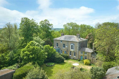
- Price
- Guide Price£850,000
- Size
- 6 acres
Old Pool Drove, Littleport, Ely, Cambs, CB6, Littleport, Cambridgeshire CB6 England
Added on 14/06/2026Country Estate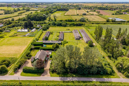
- Price
- £699,000
- Size
- 3.3 acres
Midville Lane, Stickney, Boston, Stickney, Lincolnshire PE22 England
Added on 01/07/2026Farmhouse