Lomas Lane, Sandhurst, Kent, TN18
- Land size
- 59.65 acres
- Bedrooms
- 2
- Bathrooms
- 1
Key Features
- Livestock farm
- No through lane
- Popular village
- Idyllic location
- 21,700 sq feet farm buildings
Description
This is a great livestock farm, lovely location, plenty of buildings and a comfortable home - Farms & Land
#TheGardenOfEngland
A productive grass and livestock farm in an unspoilt location and situated at the end of a no through lane a short distance from the popular village of Sandhurst with Hawkhurst, Tenterden, Cranbrook & Rye all within easy reach.
The farm is within the Kent Weald National Landscape (formerly AONB) & the Cranbrook School Catchment Area and comprises a detached 2 bedroom bungalow (Agricultural Occupancy Condition), a range of livestock buildings and surrounding pastureland.
Freehold - Council Tax Band E
About 59.65 acres
Situation
The property is situated in the Kent Weald National Landscape Area (formerly the AONB) at the far end of Lomas Lane which is a no through lane used by a number of rural properties. The farm is conveniently located with easy access to a number of local towns and villages in both Kent and East Sussex. The property falls within the Cranbrook School Catchment Area but there are a number of primary and secondary schools in the surrounding area within both the private and public sector.
Bungalow
Planning consent was granted for the bungalow on 21st August 1997 under planning reference TW/97/01339 and the sellers moved in in 2007. The bungalow occupies a convenient, slightly elevated position close to the farm buildings and provides comfortable accommodation. It is felt that there is potential for the bungalow to be extended if required.
Planning
Agricultural Occupancy Condition (AOC) – The bungalow is subject to an Agricultural Occupancy Condition which states “the occupation of the dwelling shall be limited to a person solely or mainly employed, or last employed, locally in agriculture, as defined in Section 221 (1) of the Town and Country Planning Act 1962, or in forestry, or a dependent of such a person residing with him (but including a widow or widower of such as person)”.
‘’Agriculture’’ is defined in the Town & Country Planning Act as: horticulture, fruit growing, seed growing, dairy farming, the breeding and keeping of livestock (including any creature kept for the production of food, wool, skins or fur, or for the purpose of its use in the farming of land), the use of land as grazing land, meadow land, osier land, market gardens and nursery grounds, and the use of land for woodlands where that use is ancillary to the farming of land for other agricultural purposes, and “agricultural” shall be construed accordingly.
Farm Buildings
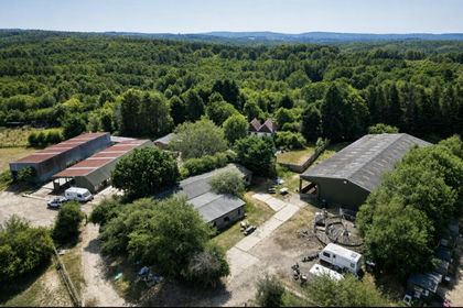
These are located close to the bungalow and provide a total of about 21,700 sq. ft. of covered space which can be used for a variety of agricultural uses. The sellers have mainly used them for housing their beef cattle but they could equally be used for lambing sheep or forage storage.
1) General Purpose Building, about 84’ x 80’ which is divided into:
a) Open Fronted Lean To
b) Enclosed Cattle Yard
c) Poultry Building
2) Cattle/Livestock Building, about 80’ x 45’.
3) Cattle/Livestock Building, about 111’ x 45’.
3) Cattle/Livestock Building, about 160’ x 40’
Just to the south of the buildings is a pond within an enclosed fenced area and a fenced poultry enclosure with 2 small poultry sheds.
Land
The land lies mainly to the north of the bungalow and buildings and includes a small wood. The land fronts the Hexden Channel along its northern boundary. There is a very pleasant outlook over the surrounding countryside.
Soil Type
The vast majority of the land is showing as part Soilscape 8 and part Soilscape 20. For further information go to (
Footpath
Footpath number WC303 passes along part of the southern boundary of the farm.
Services
Bungalow: Mains water (via private supply), mains electricity, private drainage (believed cesspool), oil fired central boiler with Electric Everhot Range for Cooking.
The sellers use Vodafone & EE mobile and have BT Broadband/Wi-Fi.
Farm Buildings: All buildings except one have mains water and single phase electricity.
Sporting Rights
These are included in the sale.
Photographs
The photographs were taken in Mar 2024.
Local Authority/Planning
All planning enquiries should be made to the local planning authority -
Tunbridge Wells Borough Council (
Boundaries, Plans and Areas
The plans on these sales particulars and the acreages quoted are strictly for identification and guidance only. They are based on Ordnance Survey plans and interested parties are reminded that the land is sold in accordance with the owners Land Registry Title plan/s and must satisfy themselves as to the boundaries and the quantity of land being purchased.
The purchaser(s) will be deemed to have full knowledge of all boundaries and any error or mistake shall not annul the sale or entitle any party to compensation thereof. The specified areas are given for guidance only and without responsibility. Purchasers should not rely on the stated areas as a statement or representation of fact but must satisfy themselves by inspection or otherwise.
Health and Safety
Prospective purchasers must have regard for their own safety during viewings. Neither the sellers nor Hobbs Parker Estate Agents accept any responsibility for any accident or injury as a result of viewing the property.
Viewing
Viewings of the farm are strictly by appointment only through either our Ashford office on or our Tenterden office on .
Our Ref: FAL230186
Map Location
Property details
- Tenure
- Freehold
- Council Tax Band
- TBC
- Date Posted
- 2026-01-28
Market Value Analysis
Compared with 85 listings of all property types in South East England (50+ acres).
Utilities & Restrictions
Utilities
- Electricity
- Ask Agent
- Water
- Ask Agent
- Heating
- Ask Agent
- Broadband
- Ask Agent
- Sewerage
- Ask Agent
Rights & Restrictions
- Public Rights of Way
- Ask Agent
- Private Rights of Way
- Ask Agent
- Listed Property
- Ask Agent
- Restrictions
- Ask Agent
Listed status, conservation areas and planning constraints for this location are in the full report.
Property Features
- Accessibility
- Ask Agent
- Parking
- Ask Agent
- Garden
- Garden
Beyond the particulars: planning activity, flood history, heritage and ground risks, checked for this exact spot.
Connectivity
Broadband
Fastest speed available at this postcode
1 Gbps
Gigabit full fibre · available to 42% of premises
Suitable for
- 4K streaming on every screen
- Full-time home working
- Online gaming & big downloads
Mobile signal
Outdoor predictions; indoor signal depends on building materials.
Ofcom Connected Nations postcode-level predictions. Speeds and signal are modelled, not measured, and vary between addresses and providers.
Signal is the easy part. Planning activity, flood history and protected designations here are in the full report.
Nearest Schools
Primary
- Sandhurst Primary School1.2 milesNo Ofsted rating
- Ages
- 5 to 11
- Pupils
- 179
- Type
- Community school
- Rolvenden Primary School2.3 milesNo Ofsted rating
- Ages
- 5 to 11
- Pupils
- 90
- Type
- Academy converter
- Northiam Church of England Primary School and Nursery2.6 milesNo Ofsted rating
- Ages
- 2 to 11
- Pupils
- 159
- Type
- Academy converter
- Faith
- Church of England
- Benenden Church of England Primary School2.8 milesNo Ofsted rating
- Ages
- 5 to 11
- Pupils
- 213
- Type
- Voluntary controlled school
- Faith
- Church of England
- Bodiam Church of England Primary School2.9 milesOfsted: Good *
- Ages
- 4 to 11
- Pupils
- 85
- Type
- Voluntary controlled school
- Faith
- Church of England
Secondary
- Cranbrook School5.5 milesOfsted report card · May 2026
- Ages
- 11 to 18
- Pupils
- 958
- Type
- Academy converter
- Faith
- Christian
- Homewood School and Sixth Form Centre5.5 milesOfsted: Good
- Ages
- 11 to 18
- Pupils
- 1,772
- Type
- Academy converter
- Robertsbridge Community College6.4 milesOfsted: Inadequate
- Ages
- 11 to 16
- Pupils
- 644
- Type
- Academy sponsor led
- Rye College7.7 milesOfsted: Good
- Ages
- 11 to 16
- Pupils
- 645
- Type
- Academy converter
- Claverham Community College9.5 milesNo Ofsted rating
- Ages
- 11 to 16
- Pupils
- 1,147
- Type
- Community school
* Latest graded judgement covers quality of education only; no overall grade was issued under the 2024-25 inspection framework.
Distances are straight-line from the advertised location. Source: the national school registers (DfE, Welsh Government, Scottish Government) and Ofsted.
Schools are just the start: sold prices nearby, planning activity and any flood history are in the full report.
Amenities
Supermarket
GP surgery
Pharmacy
Hospital
Straight-line distances from the advertised location. Sources: NHS records, Geolytix supermarket locations, OS Open Greenspace and the national trails registers.
The area stacks up? Now check the location itself: planning nearby, protected designations and past flooding.
Getting Around
Nearest station
Nearest bus stop
Typical drive times
Straight-line distances from the advertised location; drive times are typical free-flow times over OpenStreetMap road data, so allow more at peak. Public transport locations from DfT NaPTAN.
Easy to reach matters. So do planning activity, flood history and ground risks: all in the full report.
Flood Risk
From Environment Agency flood map open data, checked around the advertised map pin and allowing for the listed acreage where known. This summary comes from LandSale, the advertising platform, not from the listing agent, and is not part of the agent's particulars. Risk can vary across a single holding, so verify anything critical through your own searches before committing.
Rivers and the sea
Mapped within the area searched, not at the advertised map pin itself.
Surface water
Mapped within the area searched, not at the advertised map pin itself.
The detail behind these bandings
The full report pinpoints where this location sits on the flood maps, and runs the deeper checks that usually only surface after an offer.
- Exact flood zones & annual chances (included in the full report)
- Any recorded past flooding (included in the full report)
- Planning activity nearby (included in the full report)
- Heritage & conservation (included in the full report)
- Protected nature designations (included in the full report)
- Ground risks (included in the full report)
- Sold prices nearby (included in the full report)
£14.99 · one-off purchase
By LandSale, the platform. Not provided by the listing agent. Ready in about a minute.
Important notice: Information, maps and tags on this page are drawn from the advertising agent's marketing materials or generated automatically. LandSale has not verified them. Relying on these details is at your own risk, always carry out independent checks before committing to a purchase.
LandSale full disclaimer
Marketing information only - not formal particulars. The details on this website are provided for general guidance and do not constitute an offer or contract. Neither LandSale nor the advertising estate/land agent accepts responsibility for any inaccuracy.
1. Source of information
- Listing content: Core description, asking price, tenure, measurements, photographs and planning history originate from the marketing materials of the advertising estate or land agent. LandSale does not author this content and cannot guarantee its accuracy.
- Automated tags & categorisation: Property type, land-use class, acreage bands and similar labels may be applied by machine-learning models. They are intended as a helpful guide only and may not reflect the property's legal status or permitted use.
- Third-party & enriched data layers: Maps, boundary outlines, planning designations, soil reports, broadband coverage and other environmental or location-based insights are licensed from external suppliers. Such data are supplied “as is", may be incomplete or out of date and are subject to change without notice.
2. Verification required
Prospective purchasers must verify critical matters, including but not limited to planning permission, title boundaries, public rights of way, environmental constraints, acreage, services, access and VAT status, through their own inspections, specialist surveys, legal advisers and the selling agent before relying on the information or entering into any contract.
3. No warranty or liability
LandSale gives no warranty, express or implied, as to the accuracy, completeness or fitness for any particular purpose of the information displayed. LandSale shall not be liable for any loss, damage, cost or expense arising directly or indirectly from any use of or reliance on such information, save where liability may not be excluded by law.
4. Updates & feedback
If you believe any detail on this listing is inaccurate, please let us know. We will investigate and, where appropriate, update the listing or notify the agent.
© LandSale | Version 1.3 - August 2026
Listing agent
Hobbs Parker Estate Agents, Ashford
Romney House Monument Way, Orbital Park, Ashford, TN24 0HB
Contact Hobbs Parker Estate Agents, Ashford
Romney House Monument Way, Orbital Park, Ashford, TN24 0HB
View agent profileSimilar properties for sale
- Price
- Guide Price£1,385,000
- Size
- 33.8 acres
Ellenwhorne Lane, Staplecross, Robertsbridge, East Sussex, Ewhurst, East Sussex TN32 England
Added on 29/07/2026Equestrian property
- Price
- Guide Price£1,275,000
- Size
- 36 acres
Cannon Farm Buildings and Land, Thorn Road, Marden, Marden, Kent TN12 England
Added on 29/01/2026Farm
- Price
- Guide Price£1,300,000
- Size
- 32.38 acres
Added on 23/05/2026Farm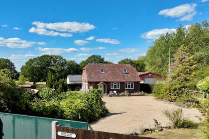
- Price
- Guide Price£1,250,000
- Size
- 37 acres
Added on 19/08/2026Agricultural Land
- Price
- Guide Price£1,250,000
- Size
- 66.32 acres
Land & Building at Charity Farm, Pilgrims Way, Hollingbourne, Kent, Hollingbourne, Kent ME17 England
Added on 02/05/2026Farmland
- Price
- Guide Price£1,275,000
- Size
- 138.92 acres
Lot 2 - Buckholt Farmland, Anvil Green, Waltham, Waltham, Kent CT4 England
Added on 20/07/2026Farm
- Price
- Guide Price£1,750,000
- Size
- 52 acres
Barcombe, Lewes, East Sussex, BN8, Barcombe, East Sussex BN8 England
Added on 11/06/2026Farmhouse
- Price
- Guide Price£1,450,000
- Size
- 62.5 acres
Added on 29/01/2026Farm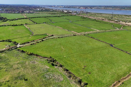
- Price
- Guide Price£1,750,000
- Size
- 275.48 acres
Land at East Court Farm, Chalk, Gravesend, Kent, Shorne, Kent DA12 England
Added on 22/04/2026Farmland