LOT 4 - Furzeley Road, Waterlooville, Hampshire, PO7
- Land size
- 5.23 acres
Key Features
- SEE AND PRINT PDF SALES PARTICULARS AVAILABLE BELOW
- SEE DRONE VIDEO FOOTAGE ON THE VIRTUAL TOUR TAB
- ATTRACTIVE BLOCK OF LEVEL PASTURELAND EXTENDING TO APPROX. 5.23 ACRES (2.11 HA).
- CURRENTLY USED FOR HORSE GRAZING, SUITABLE FOR AGRICULTURAL, EQUESTRIAN USE OR AMENITY PURPOSES.
- INCLUDES STRIP OF LAND PROVIDING A POTENTIAL SECONDARY ACCESS TO HAMBLEDON ROAD (STP).
- GOOD INTERNAL RELATIONSHIP WITH ADJOINING LOTS, ENABLING FLEXIBLE INTEGRATION IF BOUGHT WITH OTHER PARCELS.
- SURROUNDED BY SEMI-RURAL LANDSCAPE ON THE EDGE OF DENMEAD WITH STRONG CONNECTIVITY TO WATERLOOVILLE AND THE A3(M).
- POTENTIAL FOR EQUESTRIAN ENHANCEMENT OR SMALL-SCALE AMENITY DIVERSIFICATION (STP).
- AVAILABLE AS LOT 4 OF THE WIDER 17.83-ACRE MIXED-USE ESTATE, PURCHASABLE INDIVIDUALLY OR WITH OTHER LOTS.
Description
LOT 4 - Approximately 5.23 acres (2.11 ha) of level pastureland, ideal for grazing, turnout or further equestrian use.
The Property, as a Whole: An exceptional and versatile mixed-use holding on the edge of Denmead, extending to approximately 17.83 acres (7.21 ha) in all, combining residential, commercial and equestrian elements in a well-connected yet peaceful Hampshire setting. At its heart, lies a charming family home of traditional brick and flint construction, complemented by a diverse range of income-generating assets and facilities.
Offered in four Lots, or as a Whole, the Property presents a rare opportunity to acquire a site of this scale and flexibility, with established infrastructure, income potential and lifestyle appeal, as well as redevelopment potential - all within easy reach of Waterlooville, Portsmouth, the A3(M) and the South Downs.
Location: The Property is situated at Furzeley Corner, just outside the thriving village of Denmead, which offers a range of everyday amenities including shops, pubs, a primary school and local services. Despite its peaceful semi-rural setting, the Property enjoys excellent connectivity. Waterlooville is just a few minutes' drive to the east, while Junctions 2 and 3 of the A3(M) are approximately 10 minutes away, providing fast road access to Portsmouth, Petersfield, Guildford and London. The A32 and A27 are also within easy reach. Rail services are available from nearby Havant or Petersfield stations, offering regular direct trains to London Waterloo in around 1 hour 20 minutes. Southampton Airport and Portsmouth Ferry Terminal are both within a 30-minute drive, supporting both domestic and international travel.
Land Registry: The Property comprises the entirety of two Land Registry Titles HP625967 and HP660366; Register available from Selling Agent on request. Title Plans on the Selling Agents website.
Land: The northern part of the land is Grade 4 on Natural England's Provisional Land Classification Maps. The soil is identified as slowly permeable seasonally wet slightly acid but base-rich loamy and clayey soils on the National Soils Database. The pastureland comprising Lot 4 is currently in use for horse grazing.
Easement/Third Party Rights: Interested parties are advised to review the Land Registry Title Registers available on the Selling Agent's Website for full details. The following rights are referred to:
- By a Conveyance dated 24 February 1983, a right of way and right to lay and maintain utilities was reserved over a small area of land at the entrance from Furzeley Road. See Selling Agent's Website for Copy of Conveyance Plan (the affected area is shaded yellow).
- By a Conveyance dated 19 July 1972, a right to jointly use a well situated on the property was granted to a neighbour. A copy of the Conveyance is not available and it is unclear given the historic nature of this right whether it is still existing.
Public Right of Way: A Public Footpath (064/3/1) affects the western part of the Property (Lots 1 and 3) passing from the Golf Course next door and up the track to Furzeley Road, as shown by the dashed orange line on the Site Plan.
Access and New Rights of Way for Lots: Access to all parts of the Property is currently only from Furzeley Road as shown by the black arrow on the Site Plan. Lot 4 includes a strip of land which connects to the B2150 Hambledon Road as shown by the grey arrow on the Site Plan. Subject to planning approval being obtained and suitable surfacing of the access strip, this could be used as a separate access to all or part of the Property.
To facilitate access if the property is sold in separate Lots, it is proposed to create the following rights of way during the sale process:
- Lot 1 - will benefit from a right of way over the black hatched area and the red hatched area on the Site Plan.
- Lot 2 - will benefit from a right of way over the black hatched area on the Site Plan.
- Lot 4 - will benefit from a right of way over the black hatched area, the red hatched area and the turquoise hatched area on the Site Plan.
Maintenance of Accessway: The purchaser of Lot 1 shall be responsible for 15% of the cost of maintaining the parts of the accessway hatched black and red. The purchaser of Lot 3 shall be responsible for 25% of the cost of maintaining the part of the accessway hatched black. The purchaser of Lot 4 shall be responsible for 15% of the cost of maintaining the parts of the accessway coloured black, red and turquoise. The purchaser of Lot 2 shall be responsible for the remainder of the cost of maintaining the accessway.
Fencing: The purchaser of Lot 4 will be responsible for maintaining the boundary fence between Lot 4 and Lot 3. The purchaser of Lot 2 will be responsible for maintaining the boundary fence between Lot 2 and Lot 1. The purchaser of Lot 3 will be responsible for maintaining the boundary fence between Lot 3 and Lot 1.
Development Uplift: The Seller is mindful to retain a 25% share of any uplift in value caused by Planning Consent for any residential or commercial development on Lots 3 and 4 during a period of 25 years from the completion date of the sale.
Designations: The Property is within the South Hampshire Lowlands National Character area. The Property is also within a strategic gap in the current Local Plan. An area of Ancient & Semi-Natural Woodland adjoins Lot 2 to the south.
Planning History: As the planning history is fairly extensive, please follow the link to the Planning History Document on the Selling Agent's website.
Services: The Property is connected to mains water and electricity. The heating for the house is connected to mains gas. There is mains drainage.
Council Tax: Property Band = E for year 2025/2026 = £2,895.78.
Business Rates: Business rates are payable on parts of the Property including the golf driving range and cattery. See links below for further information.
- The Denmead Golf Driving Range, Furzeley Road, Denmead, Waterlooville, Hants, PO7 6TX - Current rateable value (1 April 2023 to present) = £10,000. Future rateable value (from 1st April 2026) = £14,250.
- Denmead Cattery - Current rateable value (1 April 2023 to present) = £2,900. Future rateable value (from 1st April 2026) = £3,150.
Local Authority: Winchester City Council (WCC), City Offices, Colebrook Street, Winchester SO23 9LJ.
DIRECTIONS: Postcode: PO7 6TX
FROM THE A3:
Leave the A3(M) at Junction 3, signposted Waterlooville / Denmead (B2150). At the roundabout, take the second exit onto Hulbert Road / B2150 towards Denmead. Continue on the B1250 through Waterlooville taking the 1st exit on the roundabout, the 3rd exit on the next roundabout and the 2nd exit on the following roundabout onto Hambledon Road (B2150). After approx. 1 mile upon reaching Denmead, turn left onto Forest Road and then take the next left onto Furzeley Road, signposted locally. Follow Furzeley Road for approximately 200 m. The entrance to The Paddocks / Glenfield Stud will be found on the left-hand side, immediately after passing some residential properties. There is approx. 125m of trackway before reaching the main part of the Property.
FROM DENMEAD VILLAGE CENTRE:
From Denmead village centre, head south-east on Hambledon Road (B2150) for approximately 0.5 miles. Turn right onto Forest Road onto Furzeley Road and then take the next left onto Furzeley Road, signposted locally. Follow Furzeley Road for approximately 200 m. The entrance to The Paddocks / Glenfield Stud will be found on the left-hand side, immediately after passing some residential properties. There is approx. 125m of trackway before reaching the main part of the Property.
What3Words: Canal.blending.parrot
Map Location
Property details
- Tenure
- Freehold
- Council Tax Band
- Ask Agent
- Date Posted
- 2026-01-29
Market Value Analysis
Compared with 100 Farmland & Pasture listings in South East England (5+ acres).
Utilities & Restrictions
Utilities
- Electricity
- Ask Agent
- Water
- Ask Agent
- Heating
- Ask Agent
- Broadband
- Ask Agent
- Sewerage
- Ask Agent
Rights & Restrictions
- Public Rights of Way
- Ask Agent
- Private Rights of Way
- Ask Agent
- Listed Property
- Ask Agent
- Restrictions
- Ask Agent
Listed status, conservation areas and planning constraints for this location are in the full report.
Property Features
- Accessibility
- Ask Agent
- Parking
- Ask Agent
- Garden
- Garden
Beyond the particulars: planning activity, flood history, heritage and ground risks, checked for this exact spot.
Connectivity
Broadband
Fastest speed available at this postcode
5.5 Gbps
Gigabit full fibre · available to 33% of premises
Suitable for
- 4K streaming on every screen
- Full-time home working
- Online gaming & big downloads
Mobile signal
Outdoor predictions; indoor signal depends on building materials.
Ofcom Connected Nations postcode-level predictions. Speeds and signal are modelled, not measured, and vary between addresses and providers.
Signal is the easy part. Planning activity, flood history and protected designations here are in the full report.
Nearest Schools
Primary
- Denmead Junior School773 metresNo Ofsted rating
- Ages
- 7 to 11
- Pupils
- 316
- Type
- Community school
- Denmead Infant School930 metresNo Ofsted rating
- Ages
- 4 to 7
- Pupils
- 201
- Type
- Community school
- Newlands Primary Academy1.2 milesNo Ofsted rating
- Ages
- 4 to 11
- Pupils
- 10
- Type
- Free schools
- Hart Plain Junior School1.2 milesOfsted: Requires improvement *
- Ages
- 7 to 11
- Pupils
- 179
- Type
- Community school
- Hart Plain Infant School1.2 milesNo Ofsted rating
- Ages
- 4 to 7
- Pupils
- 134
- Type
- Community school
Secondary
- The Cowplain School1.5 milesOfsted: Good
- Ages
- 11 to 16
- Pupils
- 993
- Type
- Academy converter
- Oaklands Catholic School2.3 milesOfsted report card · Apr 2026
- Ages
- 11 to 18
- Pupils
- 1,419
- Type
- Academy converter
- Faith
- Roman Catholic
- Crookhorn College2.4 milesOfsted: Good *
- Ages
- 11 to 16
- Pupils
- 943
- Type
- Foundation school
- Purbrook Park School2.4 milesNo Ofsted rating
- Ages
- 11 to 16
- Pupils
- 921
- Type
- Foundation school
- Horndean Technology College2.6 milesOfsted: Good *
- Ages
- 11 to 16
- Pupils
- 1,288
- Type
- Community school
* Latest graded judgement covers quality of education only; no overall grade was issued under the 2024-25 inspection framework.
Distances are straight-line from the advertised location. Source: the national school registers (DfE, Welsh Government, Scottish Government) and Ofsted.
Schools are just the start: sold prices nearby, planning activity and any flood history are in the full report.
Amenities
Supermarket
GP surgery
Pharmacy
Hospital
Green space
Straight-line distances from the advertised location. Sources: NHS records, Geolytix supermarket locations, OS Open Greenspace and the national trails registers.
The area stacks up? Now check the location itself: planning nearby, protected designations and past flooding.
Getting Around
Nearest station
Nearest bus stop
Typical drive times
Straight-line distances from the advertised location; drive times are typical free-flow times over OpenStreetMap road data, so allow more at peak. Public transport locations from DfT NaPTAN.
Easy to reach matters. So do planning activity, flood history and ground risks: all in the full report.
Flood Risk
From Environment Agency flood map open data, checked around the advertised map pin and allowing for the listed acreage where known. This summary comes from LandSale, the advertising platform, not from the listing agent, and is not part of the agent's particulars. Risk can vary across a single holding, so verify anything critical through your own searches before committing.
Rivers and the sea
Surface water
Mapped within the area searched, not at the advertised map pin itself.
The detail behind these bandings
The full report pinpoints where this location sits on the flood maps, and runs the deeper checks that usually only surface after an offer.
- Exact flood zones & annual chances (included in the full report)
- Any recorded past flooding (included in the full report)
- Planning activity nearby (included in the full report)
- Heritage & conservation (included in the full report)
- Protected nature designations (included in the full report)
- Ground risks (included in the full report)
- Sold prices nearby (included in the full report)
£14.99 · one-off purchase
By LandSale, the platform. Not provided by the listing agent. Ready in about a minute.
Important notice: Information, maps and tags on this page are drawn from the advertising agent's marketing materials or generated automatically. LandSale has not verified them. Relying on these details is at your own risk, always carry out independent checks before committing to a purchase.
LandSale full disclaimer
Marketing information only - not formal particulars. The details on this website are provided for general guidance and do not constitute an offer or contract. Neither LandSale nor the advertising estate/land agent accepts responsibility for any inaccuracy.
1. Source of information
- Listing content: Core description, asking price, tenure, measurements, photographs and planning history originate from the marketing materials of the advertising estate or land agent. LandSale does not author this content and cannot guarantee its accuracy.
- Automated tags & categorisation: Property type, land-use class, acreage bands and similar labels may be applied by machine-learning models. They are intended as a helpful guide only and may not reflect the property's legal status or permitted use.
- Third-party & enriched data layers: Maps, boundary outlines, planning designations, soil reports, broadband coverage and other environmental or location-based insights are licensed from external suppliers. Such data are supplied “as is", may be incomplete or out of date and are subject to change without notice.
2. Verification required
Prospective purchasers must verify critical matters, including but not limited to planning permission, title boundaries, public rights of way, environmental constraints, acreage, services, access and VAT status, through their own inspections, specialist surveys, legal advisers and the selling agent before relying on the information or entering into any contract.
3. No warranty or liability
LandSale gives no warranty, express or implied, as to the accuracy, completeness or fitness for any particular purpose of the information displayed. LandSale shall not be liable for any loss, damage, cost or expense arising directly or indirectly from any use of or reliance on such information, save where liability may not be excluded by law.
4. Updates & feedback
If you believe any detail on this listing is inaccurate, please let us know. We will investigate and, where appropriate, update the listing or notify the agent.
© LandSale | Version 1.3 - August 2026
Listing agent
Giles Wheeler-Bennett, Southampton
West Court, Lower Basingwell Street, Bishop's Waltham, SO32 1AJ
Contact Giles Wheeler-Bennett, Southampton
West Court, Lower Basingwell Street, Bishop's Waltham, SO32 1AJ
View agent profileSimilar properties for sale
- Price
- Guide Price£230,000
- Size
- 8.08 acres
Whichers Gate Road, Rowlands Castle, PO9, Rowlands Castle, Hampshire PO9 England
Added on 08/07/2026Vacant Land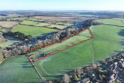
- Price
- Guide Price£300,000
- Size
- 7.12 acres
Butts Farm, Rareridge Lane, SO32, Bishops Waltham, Hampshire SO32 England
Added on 29/01/2026Pasture
- Price
- £300,000
- Size
- 2.24 acres
Hambrook Hill North, Hambrook, Westbourne, West Sussex PO18 England
Added on 29/01/2026Equestrian property
- Price
- Offers in Excess of£200,000
- Size
- 6.01 acres
Meonmarsh, Bridge Street, Fareham, Hampshire, PO14, Hamble Valley, Hampshire PO14 England
Added on 29/01/2026Wetland
- Price
- Guide Price£275,000
- Size
- 8.16 acres
Calcot Paddocks, Calcot Lane, SO32, Curdridge, Hampshire SO32 England
Added on 11/04/2026Equestrian property
- Price
- Guide Price£290,000
- Size
- 9.75 acres
Stoner Hill Road, GU32, Froxfield and Privett, Hampshire GU32 England
Added on 29/01/2026Pasture
- Price
- Offers in Region of£225,000
- Size
- 6.9 acres
Willow Lodge Farm, Nyewood Road, Nyewood, South Harting, GU31, Harting, West Sussex GU31 England
Added on 27/06/2026Pasture
- Price
- Guide Price£240,000
- Size
- 5.97 acres
Added on 15/05/2026Pasture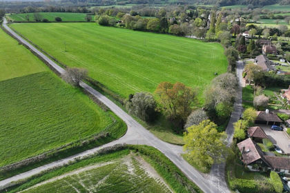
- Price
- Guide Price£255,000
- Size
- 6.22 acres
Added on 15/05/2026Grazing Land
- Price
- Guide Price£225,000
- Size
- 10.46 acres
Added on 29/01/2026Grazing Land