
Galltegfa, Ruthin
- Land size
- 2.3 acres
- Bedrooms
- 3
- Bathrooms
- 1
Description
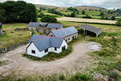
A rare opportunity to acquire a detached three-bedroom residence occupying an attractive rural position at Galltegfa, near Ruthin, together with gardens, ancillary outbuildings and two paddocks, with the property extending to approximately 2.3 acres in total. Available as a whole or in two lots.
Lot 1: Bryn Clwyd enjoys far-reaching views across the surrounding countryside and offers considerable scope for refurbishment and improvement, providing purchasers with the opportunity to create a home tailored to their individual requirements.
The accommodation is arranged over two floors and includes two reception rooms, a kitchen, utility room and ground-floor WC, together with three bedrooms and a family bathroom on the first floor. An attached double garage provides additional practical space. Externally, the property benefits from established garden areas and useful ancillary outbuildings. Lot 1 outlined green in the plan.
Lot 2: Two paddocks, situated on the opposite side of the adjoining road, provide additional land suitable for a variety of amenity purposes, subject to any necessary consents. Lot 2 outlined red in the plan.
Whilst requiring modernisation, Bryn Clwyd offers an appealing combination of residential accommodation, land and rural surroundings, making it particularly worthy of consideration by purchasers seeking a countryside home with additional outdoor space.
Services - Lot 1: Bryn Clwyd dwelling
Mains electricity and water are understood to be connected to the dwelling. Private drainage is understood to be provided by a septic tank. There is no central heating system.
Lot 2: Land
The seller advises that the land benefits from a mains water supply.
Method Of Sale - The property is offered for sale by Private Treaty as a whole or in two lots.
Directions - Using the postcode LL15 2AR. Turn off the B5105 sign posted for ‘Clocaenog’ and Bryn Clwyd will be found after a short distance on the left hand side. Identified by our for sale board.
Tenure & Possession - The freehold of the property is offered with vacant possession on completion of sale.
Agricultural Support - The Vendor has not claimed agricultural support payments in respect of the land, and no agricultural support entitlements are included in the sale.
The land may be eligible for inclusion within the Sustainable Farming Scheme (SFS), subject to the Purchaser satisfying the relevant eligibility criteria and complying with the scheme requirements. Prospective Purchasers are advised to make their own enquiries regarding eligibility.
Boundaries - The boundaries are indicated on the accompanying plan for identification purposes only. Prospective purchasers should satisfy themselves as to the precise boundaries and their ownership by reference to the title documentation and inspection of the property.
Planning - The selling agents are not aware of any current planning applications relating to the property. The property is understood to lie outside the defined settlement development boundary.
Prospective purchasers should make their own enquiries with the Local Planning Authority regarding any proposed use or development.
Wayleaves, Easements & Rights Of Way - The property will be sold subject to and with the benefit of all wayleaves, easements and rights of way whether mentioned in these particulars or not.
Local Authority - Denbighshire County Council.
Mines, Minerals & Sporting Rights - All mines, minerals and sporting rights owned by the seller, insofar as they are available, are included in the sale.
Viewings - Strictly by confirmed appointment with the seller’s agents, Baileys & Partners –
Health & Safety - Prospective purchasers are advised to exercise caution when inspecting the property, particularly around the outbuildings, uneven surfaces and agricultural land. All viewings are undertaken at the visitor's own risk, and visitors should follow any instructions provided by the selling agents.
Vat - We understand that the Seller has not exercised an option to tax in respect of the property.
Disclaimer - These particulars, whilst believed to be accurate, are set for guidance only and do not constitute any part of an offer or contract. Prospective purchasers should not rely on them as statements or representations of fact, but must satisfy themselves by inspection or otherwise of their accuracy. No person in the employment of Baileys & Partners has the authority to make or give any representations or warranties in relation to the property.
Map Location
Property details
- Tenure
- Freehold
- Council Tax Band
- G
- Date Posted
- 2026-10-28
Market Value Analysis
Compared with 1,017 Homes with Land listings in Wales (1+ acres).
Utilities & Restrictions
Utilities
- Electricity
- Ask Agent
- Water
- Ask Agent
- Heating
- Ask Agent
- Broadband
- Ask Agent
- Sewerage
- Ask Agent
Rights & Restrictions
- Public Rights of Way
- Ask Agent
- Private Rights of Way
- Ask Agent
- Listed Property
- Ask Agent
- Restrictions
- Ask Agent
Listed status, conservation areas and planning constraints for this location are in the full report.
Property Features
- Accessibility
- Ask Agent
- Parking
- Parking Available
- Garden
- Garden
Beyond the particulars: planning activity, flood history, heritage and ground risks, checked for this exact spot.
Connectivity
Broadband
Fastest speed available at this postcode
14 Mbps
Standard (10-30 Mbps)
Suitable for
- Web & social
- Music streaming
- Standard video calls
Mobile signal
Predicted 4G and 5G signal; indoor signal depends on building materials.
Ofcom Connected Nations postcode-level predictions. Speeds and signal are modelled, not measured, and vary between addresses and providers.
Signal is the easy part. Planning activity, flood history and protected designations here are in the full report.
Nearest Schools
Primary
- Ysgol Pen Barras0.7 miles
- Pupils
- 293
- Type
- Nursery, Infants & Juniors
- Language
- Welsh medium school / provision (including transitional)
- Rhos Street CP School0.7 miles
- Pupils
- 223
- Type
- Nursery, Infants & Juniors
- Language
- English medium school / provision
- Ysgol Borthyn0.7 miles
- Pupils
- 101
- Type
- Nursery, Infants & Juniors
- Language
- English medium school / provision
- Ysgol Llanfair Dyffryn Clwyd2.2 miles
- Pupils
- 122
- Type
- Nursery, Infants & Juniors
- Language
- Dual language school / provision (Welsh and English) (including transitional)
- Ysgol Llanbedr2.4 miles
- Pupils
- 52
- Type
- Nursery, Infants & Juniors
- Language
- English medium school / provision
Secondary
- Ysgol Brynhyfryd1.6 miles
- Pupils
- 1,121
- Type
- Secondary (ages 11-19)
- Language
- Dual language school / provision (Welsh and English) (including transitional)
- Denbigh High School6.1 miles
- Pupils
- 497
- Type
- Secondary (ages 11-19)
- Language
- English medium school / provision
- St Brigid's School6.8 miles
- Pupils
- 484
- Type
- Middle (ages 3-19)
- Language
- English medium school / provision
- Alun School8.8 miles
- Pupils
- 1,480
- Type
- Secondary (ages 11-19)
- Language
- English medium school / provision
- Maes Garmon8.8 miles
- Pupils
- 578
- Type
- Secondary (ages 11-19)
- Language
- Welsh medium school / provision (including transitional)
Distances are straight-line from the advertised location. Source: the national school registers (DfE, Welsh Government, Scottish Government) and Ofsted.
Schools are just the start: sold prices nearby, planning activity and any flood history are in the full report.
Amenities
Supermarket
GP surgery
Pharmacy
Green space
Straight-line distances from the advertised location. Sources: NHS records, Geolytix supermarket locations, OS Open Greenspace and the national trails registers.
The area stacks up? Now check the location itself: planning nearby, protected designations and past flooding.
Getting Around
Nearest station
Nearest bus stop
Typical drive times
Straight-line distances from the advertised location; drive times are typical free-flow times over OpenStreetMap road data, so allow more at peak. Public transport locations from DfT NaPTAN.
Easy to reach matters. So do planning activity, flood history and ground risks: all in the full report.
Flood Risk
Natural Resources Wales open data, checked around the advertised map pin for the listed acreage. Long-term risk counts flood defences; the planning map's flood zones do not. Provided by LandSale, not the listing agent, and not part of the agent's particulars. Risk varies across a holding, so verify before committing.
Rivers and the sea
Planning map: Flood Zone 1.
Surface water
Not at the pin: mapped about 20 metres away.
These bandings are the summary. Where this location sits on the flood maps, plus planning activity, heritage and ground risks, is in the full report.
Important notice: Information, maps and tags on this page are drawn from the advertising agent's marketing materials or generated automatically. LandSale has not verified them. Relying on these details is at your own risk, always carry out independent checks before committing to a purchase.
LandSale full disclaimer
Marketing information only - not formal particulars. The details on this website are provided for general guidance and do not constitute an offer or contract. Neither LandSale nor the advertising estate/land agent accepts responsibility for any inaccuracy.
1. Source of information
- Listing content: Core description, asking price, tenure, measurements, photographs and planning history originate from the marketing materials of the advertising estate or land agent. LandSale does not author this content and cannot guarantee its accuracy.
- Automated tags & categorisation: Property type, land-use class, acreage bands and similar labels may be applied by machine-learning models. They are intended as a helpful guide only and may not reflect the property's legal status or permitted use.
- Third-party & enriched data layers: Maps, boundary outlines, planning designations, soil reports, broadband coverage and other environmental or location-based insights are licensed from external suppliers. Such data are supplied “as is", may be incomplete or out of date and are subject to change without notice.
2. Verification required
Prospective purchasers must verify critical matters, including but not limited to planning permission, title boundaries, public rights of way, environmental constraints, acreage, services, access and VAT status, through their own inspections, specialist surveys, legal advisers and the selling agent before relying on the information or entering into any contract.
3. No warranty or liability
LandSale gives no warranty, express or implied, as to the accuracy, completeness or fitness for any particular purpose of the information displayed. LandSale shall not be liable for any loss, damage, cost or expense arising directly or indirectly from any use of or reliance on such information, save where liability may not be excluded by law.
4. Updates & feedback
If you believe any detail on this listing is inaccurate, please let us know. We will investigate and, where appropriate, update the listing or notify the agent.
© LandSale | Version 1.3 - August 2026
Similar properties for sale
- Price
- Guide Price£405,000
- Size
- 1.58 acres
Plas Lane, Llanarmon-yn-Ial, Mold, Denbighshire, CH7, Llanarmon-yn-Ial, Denbighshire CH7 Wales
Added on 18/09/2026Development Land
- Price
- Offers in Region of£315,000
- Size
- 3.5 acres
Added on 25/04/2026Cottage
- Price
- £399,500
- Size
- 1 acres
Added on 08/07/2026Farmhouse
- Price
- £390,000
- Size
- 2.3 acres
Groesffordd Marli, Abergele, Llanfair Talhaiarn, Conwy LL22 Wales
Added on 20/10/2026Cottage
- Price
- £450,000
- Size
- 1.12 acres
Groesffordd Marli, Abergele, Llanfair Talhaiarn, Conwy LL22 Wales
Added on 06/06/2026House with Land
- Price
- Offers in Region of£425,000
- Size
- 3.5 acres
Added on 17/08/2026Cottage
- Price
- £375,000
- Size
- 1.15 acres
Added on 10/06/2026House with Land
- Price
- Offers in Region of£450,000
- Size
- 1.3 acres
Gwellyn Avenue, Kinmel Bay, Denbighshire, LL18, Kinmel Bay and Towyn, Conwy LL18 Wales
Added on 27/10/2026House with Land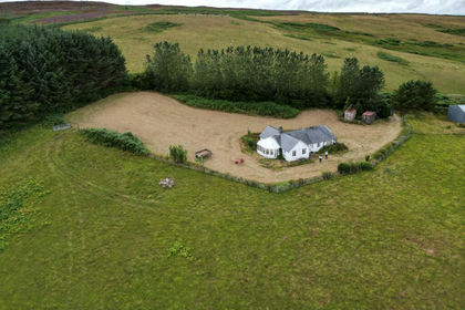
- Price
- Guide Price£300,000
- Size
- 1 acres
Hafod Dinam, Llandrillo, Corwen, Llandrillo, Denbighshire LL21 Wales
Added on 15/09/2026House with Land
- Price
- Offers Over£295,000
- Size
- 6 acres
Added on 29/01/2026Building Plot