
Holywell Hall, Brancepeth
- Land size
- 28.59 acres
- Bedrooms
- 9
- Bathrooms
- 6
Key Features
- Grade II* listed Georgian Hall arranged over three floors with a rich history and period character.
- Former Coach House with flat above, accessed both internally and externally.
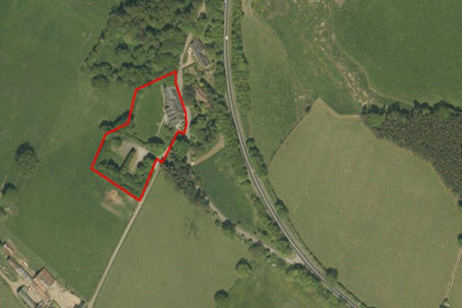
- Set within 28.59 acres, including formal gardens, parklandstyle paddocks, amenity woodland and a naturally fed lake.
- Quiet and secluded position located close to the highly sought-after idyllic village of Brancepeth and approximately 5 miles from Durham City Centre.
- For sale as a whole.
Description
An exceptional Grade II* listed country house in a secluded rural setting with annex accommodation, gardens, paddocks, woodland and a lake.
In all approximately 28.59 acres (11.57 hectares).
For sale as a whole.
Description - Holywell Hall extends to 28.59 acres in total and presents a rare opportunity to acquire a substantial and historically significant country house in an attractive rural setting.
The property combines considerable Georgian period character with extensive accommodation, an internally linked annex, gardens, woodland, parkland pasture and a lake.
Situation - Situated within a wonderfully quiet rural position, Holywell Hall is surrounded by arable land, grassland and woodland, just west of the River Wear. The property lies 2.7 miles south-east of the desirable village of Brancepeth, which is steeped in local heritage, and approximately 5 miles south-west of Durham City, offering convenient access to shops, restaurants and amenities. Durham Railway Station is approximately 3.3 miles away, providing regular rail services on the East Coast Main Line, while Junction 61 of the A1(M) is just under 10 miles away.
The property benefits from a choice of well-regarded primary and secondary schools in nearby New Brancepeth, Brandon and Durham.
Holywell Hall - Forming the principal part of the country house, which is now divided between the Hall and the separately owned West Wing, the Hall is understood to date principally from the early to mid-18th century incorporating the original Hall (the now dining room) and is documented as standing in 1402 as the Constable’s house for Brancepeth Castle. The Hall has considerable character and historic interest. It is reputed that the land at Holywell served as a resting place for the body of St Cuthbert, the patron saint of Northumbria, during its journey across the region following his death, when it was moved to protect it from Viking attacks. Later, in around 1402, the Hall was used to accommodate the Constables of Brancepeth Castle.
It is approached through a wrought iron gate between traditional Grade II listed piers creating a charming sense of arrival. Its refined façade, with elegant sash windows and centrally positioned pedimented entrance, is a highlight of its period history. Formal lawns extend from the front and side of the property and have been planted with mature herbaceous borders and a rose covered archway.
The setting is a key feature, with private drive access and a gravel sweep leading to garage parking. It neighbours the partly walled garden which separates the driveway from the parkland style main paddock. To enhance the uninterrupted view from the Hall, a ha-ha wall divides the front lawn from the paddock.
The Hall offers substantial family accommodation arranged over three floors, extending to over 5,000 sq ft.
Former Coach House - In addition to the main Hall, the property includes a separately, Grade II listed former Coach House, now converted to a flat with garage below, which is accessed internally from the Hall or via its own external entrance. The flat, now in need of modernisation, comprises:
Former Coach House Annex: kitchen, sitting room, two bedrooms and a Jack and Jill shower room, with double garage below.
It provides the perfect ancillary accommodation for additional guests, staff or multi-generational living.
The Land - The land extends in total to about 28.44 acres (11.51 hectares). The permanent pasture features parkland trees and is currently used for horse grazing. It offers scope for further management and improvement to maximise productivity should this be required.
The amenity woodland, with the Holywell Beck flowing through, is predominately situated to the east of the holding, providing quiet enjoyment and a safe haven for wildlife.
The diverse garden spaces, ranging from the historic part-walled kitchen garden, once used for growing herbs, vegetables and flowers, to formal lawns framed by mature specimen trees and yew hedging, are connected via attractive stone terraces and pathways. The gardens gradually give way to the old orchard woodland with a sunken garden at the far end and culminating at the picturesque lake and creating a wonderful sense of exploration throughout the grounds. The lake attracts a variety of wildlife and flora. The property boundary straddles the lake and is shown on the Land Registry plan.
The land is currently subject to an informal horse grazing licence and will be vacant before the completion of the sale.
Outbuildings - The ancillary buildings include a semi-detached double garage, a semi-derelict folly and purpose-built aviaries beyond the orchard garden. The pigeon lofts and stables are not included in the sale and will be removed before completion.
Designations - Holywell Hall is Grade II* listed, whilst the former Coach House annex, gate piers and garden wall (east of Holywell Hall) are Grade II listed. Interested parties should make their own enquiries of the local planning authority in respect of any works, alterations or consents required.
Sporting And Mineral Rights - Sporting Rights are included in the sale in so far as they are owned. Most of the Mineral Rights are excepted from the sale as they are owned by a third party. The Mineral Rights surrounding the Hall and gardens are included in the sale in so far as they are owned.
Viewings - Viewings will be strictly by appointment through the Selling Agent, GSC Grays.
All appointments will be accompanied and every effort will be made to accommodate preferred viewing times.
All parties attending are asked to remain vigilant, particularly around buildings, machinery and livestock.
Directions - From Brancepeth, proceed south-east on Scripton Road towards Holywell Hall. The property is situated at the end of a no-through road.
What3Words: ///ties.binds.probably
Map Location
Property details
- Tenure
- Freehold
- Council Tax Band
- H
- Date Posted
- 2026-10-28
Market Value Analysis
Compared with 10 Homes with Land listings in North East England (25+ acres).
Utilities & Restrictions
Utilities
- Electricity
- Mains
- Water
- Mains
- Heating
- Oil Heating
- Broadband
- Ask Agent
- Sewerage
- Septic Tank / Private
Rights & Restrictions
- Public Rights of Way
- Ask Agent
- Private Rights of Way
- Ask Agent
- Listed Property
- Yes
- Restrictions
- Ask Agent
Listed status, conservation areas and planning constraints for this location are in the full report.
Property Features
- Accessibility
- Ask Agent
- Parking
- Garage
- Garden
- Garden
Beyond the particulars: planning activity, flood history, heritage and ground risks, checked for this exact spot.
Connectivity
Broadband
Fastest speed available at this postcode
2 Mbps
Under 10 Mbps here
Suitable for
- Basic browsing & email
Mobile signal
Predicted 4G and 5G signal; indoor signal depends on building materials.
Ofcom Connected Nations postcode-level predictions. Speeds and signal are modelled, not measured, and vary between addresses and providers.
Signal is the easy part. Planning activity, flood history and protected designations here are in the full report.
Nearest Schools
Primary
- Browney Primary Academy1.2 milesNo Ofsted rating
- Ages
- 4 to 11
- Pupils
- 181
- Type
- Academy sponsor led
- Tudhoe Colliery Primary School1.3 milesOfsted: Good *
- Ages
- 4 to 11
- Pupils
- 212
- Type
- Academy converter
- Brandon Primary Academy1.5 milesOfsted: Good *
- Ages
- 2 to 11
- Pupils
- 280
- Type
- Academy converter
- St Patrick's Catholic Primary School, Langley Moor1.7 milesOfsted: Good *
- Ages
- 4 to 11
- Pupils
- 66
- Type
- Academy converter
- Faith
- Roman Catholic
- Springmoor Grange School1.9 milesOfsted: Good
- Ages
- 2 to 11
- Pupils
- 415
- Type
- Community school
Secondary
- Whitworth Park Academy2.5 milesOfsted: Good
- Ages
- 11 to 16
- Pupils
- 996
- Type
- Academy sponsor led
- Durham Johnston Comprehensive School3.5 milesOfsted: Good *
- Ages
- 11 to 18
- Pupils
- 1,667
- Type
- Community school
- Parkside Academy3.5 milesOfsted: Good
- Ages
- 11 to 16
- Pupils
- 833
- Type
- Academy converter
- Ferryhill School3.5 milesNo Ofsted rating
- Ages
- 11 to 16
- Pupils
- 727
- Type
- Academy converter
- Durham Academy3.7 milesOfsted report card · Jan 2026
- Ages
- 11 to 16
- Pupils
- 405
- Type
- Academy converter
* Latest graded judgement covers quality of education only; no overall grade was issued under the 2024-25 inspection framework.
Distances are straight-line from the advertised location. Source: the national school registers (DfE, Welsh Government, Scottish Government) and Ofsted.
Schools are just the start: sold prices nearby, planning activity and any flood history are in the full report.
Amenities
Supermarket
GP surgery
Pharmacy
Hospital
Straight-line distances from the advertised location. Sources: NHS records, Geolytix supermarket locations, OS Open Greenspace and the national trails registers.
The area stacks up? Now check the location itself: planning nearby, protected designations and past flooding.
Getting Around
Nearest station
Nearest bus stop
Typical drive times
Straight-line distances from the advertised location; drive times are typical free-flow times over OpenStreetMap road data, so allow more at peak. Public transport locations from DfT NaPTAN.
Easy to reach matters. So do planning activity, flood history and ground risks: all in the full report.
Flood Risk
Environment Agency open data, checked around the advertised map pin for the listed acreage. Long-term risk counts flood defences; the planning map's flood zones do not. Provided by LandSale, not the listing agent, and not part of the agent's particulars. Risk varies across a holding, so verify before committing.
Rivers and the sea
Not at the pin: mapped about 110 metres away.
Planning map: Flood Zone 3, about 110 metres away.
Surface water
Not at the pin: mapped about 30 metres away.
These bandings are the summary. Where this location sits on the flood maps, plus planning activity, heritage and ground risks, is in the full report.
Important notice: Information, maps and tags on this page are drawn from the advertising agent's marketing materials or generated automatically. LandSale has not verified them. Relying on these details is at your own risk, always carry out independent checks before committing to a purchase.
LandSale full disclaimer
Marketing information only - not formal particulars. The details on this website are provided for general guidance and do not constitute an offer or contract. Neither LandSale nor the advertising estate/land agent accepts responsibility for any inaccuracy.
1. Source of information
- Listing content: Core description, asking price, tenure, measurements, photographs and planning history originate from the marketing materials of the advertising estate or land agent. LandSale does not author this content and cannot guarantee its accuracy.
- Automated tags & categorisation: Property type, land-use class, acreage bands and similar labels may be applied by machine-learning models. They are intended as a helpful guide only and may not reflect the property's legal status or permitted use.
- Third-party & enriched data layers: Maps, boundary outlines, planning designations, soil reports, broadband coverage and other environmental or location-based insights are licensed from external suppliers. Such data are supplied “as is", may be incomplete or out of date and are subject to change without notice.
2. Verification required
Prospective purchasers must verify critical matters, including but not limited to planning permission, title boundaries, public rights of way, environmental constraints, acreage, services, access and VAT status, through their own inspections, specialist surveys, legal advisers and the selling agent before relying on the information or entering into any contract.
3. No warranty or liability
LandSale gives no warranty, express or implied, as to the accuracy, completeness or fitness for any particular purpose of the information displayed. LandSale shall not be liable for any loss, damage, cost or expense arising directly or indirectly from any use of or reliance on such information, save where liability may not be excluded by law.
4. Updates & feedback
If you believe any detail on this listing is inaccurate, please let us know. We will investigate and, where appropriate, update the listing or notify the agent.
© LandSale | Version 1.3 - August 2026
Listing agent
GSC Grays, Farm Agency5-6 Bailey Court, Colburn Business Park, Catterick Garrison, DL9 4QL
Contact GSC Grays, Farm Agency
5-6 Bailey Court, Colburn Business Park, Catterick Garrison, DL9 4QL
View agent profileSimilar properties for sale
- Price
- Guide Price£750,000
- Size
- 1.8 acres
Land At Helme Park Hotel, Tow Law, Bishop Auckland, DL13, Wolsingham, County Durham DL13 England
Added on 29/01/2026Redevelopment Land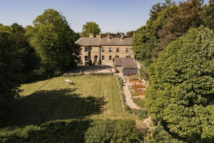
- Price
- Guide Price£925,000
- Size
- 1 acres
Cookson House, Colepike Hall, Lanchester, County Durham, Lanchester, County Durham DH7 England
Added on 29/01/2026House with Land
- Price
- Guide Price£800,000
- Size
- 5 acres
Mordon, Stockton-On-Tees, TS21, Mordon, County Durham TS21 England
Added on 23/04/2026Country Home
- Price
- Guide Price£1,200,000
- Size
- 10.18 acres
Glenholme Farm, Hamsterley, County Durham, Hamsterley, County Durham DL13 England
Added on 31/07/2026House with Land
- Price
- Guide Price£735,000
Added on 21/09/2026Barn Conversion
- Price
- £1,200,000
- Size
- 4 acres
The White House, Durham, TS27 4, Sheraton with Hulam, County Durham TS27 England
Added on 29/01/2026House with Land
- Price
- Guide Price£1,295,000
- Size
- 2.85 acres
Added on 22/07/2026Country Home
- Price
- £750,000
- Size
- 4.5 acres
High Waskley Farm, Shotley Bridge, Consett, Shotley Low Quarter, Northumberland DH8 England
Added on 01/10/2026House with Land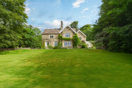
- Price
- Guide Price£950,000
- Size
- 7.2 acres
Ashes House, Stanhope, County Durham, Stanhope, County Durham DL13 England
Added on 29/01/2026Country Home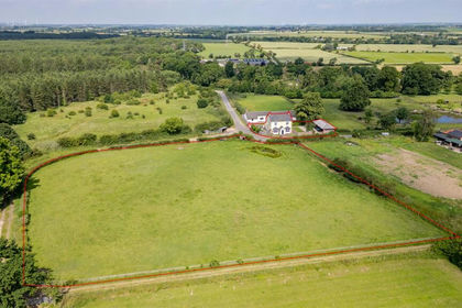
- Price
- Guide Price£750,000
- Size
- 1.9 acres
Added on 08/07/2026Country Home