Cookson House, Colepike Hall, Lanchester, County Durham
- Land size
- 1 acres
- Bedrooms
- 4
- Bathrooms
- 2
Key Features
- Grade II Listed Wing of Historic Colepike Hall
- Extensively Renovated with Period Features Retained
- Gardens and Woodland Extending to Over One Acre
- Detached Outbuilding with Gym and Store
- Kitchen Garden
Description
Accommodation in Brief
Ground Floor
Entrance Hallway| Drawing Room | Dining Room | Study | Kitchen | Utility | Rear Hall | WC
First Floor
Principal Bedroom with Dressing Room and En-Suite | Three Further Bedrooms | Bathroom
Outbuildings
Detached Double Garage configured as Gym and Store
The Property
Cookson House forms the eastern wing of the Grade II listed Colepike Hall, a handsome stone-built home set in approximately one acre of formal gardens, fenced paddock and woodland, with superb views over the Browney Valley. Approached via a long, tree-lined drive, the setting feels deeply private, yet remains just a mile and a half from the centre of Lanchester and within easy reach of Durham City.
Believed to date from the early-to-mid 1800s, the house retains a wealth of original architectural detail—deep sash windows with working shutters, ornate ceiling cornices, and stone fireplaces with carved surrounds, while the interior has been extensively renovated in recent years to create a comfortable and highly individual family home. A restrained, natural palette ties the spaces together, allowing the scale and character of the rooms to take focus.
From the entrance hall, the accommodation unfolds through a sequence of generously proportioned rooms. The drawing room occupies the southern end of the plan, with a deep bay window drawing in the light and original features including a carved marble fireplace, ornate cornicing, and a ceiling rose clearly preserved. Opposite, a study overlooks the front garden, while beyond, the formal dining room centres on a log-burning stove set into a granite surround and links directly to the kitchen.
Fitted with sleek white cabinetry, curved granite worktops and a full suite of integrated appliances including a Bosch oven, Miele dishwasher, full-height fridge and freezer, and Whirlpool coffee machine—the kitchen is contemporary in feel and function. Beyond, a rear hallway leads to the utility and WC – completing the ground floor.
The first floor offers four bedrooms arranged off a central landing. Arch windows and tall ceilings give these rooms a distinctive stately aesthetic. Decorated in tasteful, muted tones, the principal bedroom is elegantly composed with panel moulding, and three large sash windows providing ample light. A potential fifth bedroom is currently configured as a walk-through dressing room, leading to a generous en-suite complete with bathtub, separate shower, and vanity unit. A further bathroom serves the remaining bedrooms.
Externally
The house stands in around an acre of grounds, with a broad gravel drive providing ample parking to the front. To one side, a gravelled dining terrace sits against a backdrop of mature borders, while a lawned area extends towards a small section of woodland. A detached outbuilding currently houses a gym and store, and beyond, the original kitchen garden walls border a productive area with a greenhouse, fruit trees, raised beds and a wood-fired sauna.
Local Information
Lanchester is a sought-after and well-established village in County Durham, set within the scenic Browney Valley and surrounded by open countryside. The village offers a range of everyday amenities including independent shops, cafés, pubs and a post office, along with a doctors’ surgery and pharmacy. For families, the area is served by both a primary school and the highly regarded St Bede’s Catholic School and Sixth Form College.
The nearby Lanchester Valley Railway Path and surrounding bridleways provide access to countryside walks and cycling routes, while the village’s position allows for easy access to the wider region. Durham City is around eight miles to the east and offers a wide range of shops, restaurants and cultural attractions, along with the world heritage site of Durham Cathedral and Castle. Newcastle lies just 16 miles to the north and is easily reached by road.
For the commuter, Lanchester offers convenient road links to Durham, Newcastle and the wider North East. Mainline rail services from Durham connect directly to London and Edinburgh, and Newcastle International Airport provides both domestic and international flights.
Approximate Mileages
Lanchester 1.8 miles | St Bede’s Catholic School 2.5 miles | Durham 9.6 miles | Durham School 9.9 miles | Newcastle Upon Tyne 16 miles | Newcastle International Airport 29.4 miles
Services
Mains electricity & water. Private drainage to septic tank. Biomass central heating.
Tenure
Freehold
Wayleaves, Easements & Rights of Way
The property is being sold subject to all existing wayleaves, easements and rights of way, whether or not specified within the sales particulars.
Agents Note to Purchasers
We strive to ensure all property details are accurate, however, they are not to be relied upon as statements of representation or fact and do not constitute or form part of an offer or any contract. All measurements and floor plans have been prepared as a guide only. All services, systems and appliances listed in the details have not been tested by us and no guarantee is given to their operating ability or efficiency. Please be advised that some information may be awaiting vendor approval.
Submitting an Offer
Please note that all offers will require financial verification including mortgage agreement in principle, proof of deposit funds, proof of available cash and full chain details including selling agents and solicitors down the chain. To comply with Money Laundering Regulations, we require proof of identification from all buyers before acceptance letters are sent and solicitors can be instructed.
Disclaimer
The information displayed about this property comprises a property advertisement. Finest Properties strives to ensure all details are accurate; however, they do not constitute property particulars and should not be relied upon as statements of fact or representation. All information is provided and maintained by Finest Properties.
Map Location
Property details
- Tenure
- Freehold
- Council Tax Band
- G
- Date Posted
- 2026-01-29
Price history
| Date | Change | Price |
|---|---|---|
| 14 Oct 2026 | Reduced 2.6% (−£25,000) | £925,000 |
| Until 14 Oct 2026 | Asking price | £950,000 |
Market Value Analysis
Compared with 202 Homes with Land listings in North East England (1+ acres).
Utilities & Restrictions
Utilities
- Electricity
- Mains
- Water
- Mains
- Heating
- Biomass Boiler
- Broadband
- Ask Agent
- Sewerage
- Septic Tank / Private
Rights & Restrictions
- Public Rights of Way
- Ask Agent
- Private Rights of Way
- Ask Agent
- Listed Property
- Yes
- Restrictions
- Ask Agent
Listed status, conservation areas and planning constraints for this location are in the full report.
Property Features
- Accessibility
- Ask Agent
- Parking
- Parking Available
- Garden
- Private Garden
Beyond the particulars: planning activity, flood history, heritage and ground risks, checked for this exact spot.
Connectivity
Broadband
Fastest speed available at this postcode
1.8 Gbps
Gigabit full fibre · available to 67% of premises
Suitable for
- 4K streaming on every screen
- Full-time home working
- Online gaming & big downloads
Mobile signal
Predicted 4G and 5G signal; indoor signal depends on building materials.
Ofcom Connected Nations postcode-level predictions. Speeds and signal are modelled, not measured, and vary between addresses and providers.
Signal is the easy part. Planning activity, flood history and protected designations here are in the full report.
Nearest Schools
Primary
- All Saints' Catholic Primary School, Lanchester1.5 milesNo Ofsted rating
- Ages
- 3 to 11
- Pupils
- 165
- Type
- Academy converter
- Faith
- Roman Catholic
- Lanchester Endowed Parochial Primary School1.6 milesNo Ofsted rating
- Ages
- 2 to 11
- Pupils
- 455
- Type
- Voluntary controlled school
- Faith
- Church of England
- Burnhope Primary School3 milesNo Ofsted rating
- Ages
- 3 to 11
- Pupils
- 69
- Type
- Academy converter
- Delves Lane Primary School3 milesOfsted report card · Jun 2026
- Ages
- 2 to 11
- Pupils
- 274
- Type
- Community school
- St Michael's Catholic Primary School, Esh Village3.4 milesOfsted: Good
- Ages
- 3 to 11
- Pupils
- 203
- Type
- Academy converter
- Faith
- Roman Catholic
Secondary
- St Bede's Catholic School and Sixth Form College, Lanchester1.8 milesOfsted report card · Mar 2026
- Ages
- 11 to 18
- Pupils
- 1,240
- Type
- Academy converter
- Faith
- Roman Catholic
- Consett Academy4 milesOfsted: Good
- Ages
- 11 to 18
- Pupils
- 1,493
- Type
- Academy sponsor led
- Tanfield School5.5 milesOfsted: Good *
- Ages
- 11 to 16
- Pupils
- 739
- Type
- Academy sponsor led
- North Durham Academy5.5 milesOfsted: Good
- Ages
- 11 to 16
- Pupils
- 935
- Type
- Academy sponsor led
- Durham Academy5.8 milesOfsted report card · Jan 2026
- Ages
- 11 to 16
- Pupils
- 405
- Type
- Academy converter
* Latest graded judgement covers quality of education only; no overall grade was issued under the 2024-25 inspection framework.
Distances are straight-line from the advertised location. Source: the national school registers (DfE, Welsh Government, Scottish Government) and Ofsted.
Schools are just the start: sold prices nearby, planning activity and any flood history are in the full report.
Amenities
Supermarket
GP surgery
Pharmacy
Hospital
Straight-line distances from the advertised location. Sources: NHS records, Geolytix supermarket locations, OS Open Greenspace and the national trails registers.
The area stacks up? Now check the location itself: planning nearby, protected designations and past flooding.
Getting Around
Nearest station
Nearest bus stop
Typical drive times
Straight-line distances from the advertised location; drive times are typical free-flow times over OpenStreetMap road data, so allow more at peak. Public transport locations from DfT NaPTAN.
Easy to reach matters. So do planning activity, flood history and ground risks: all in the full report.
Flood Risk
Environment Agency open data, checked around the advertised map pin for the listed acreage. Long-term risk counts flood defences; the planning map's flood zones do not. Provided by LandSale, not the listing agent, and not part of the agent's particulars. Risk varies across a holding, so verify before committing.
Rivers and the sea
Planning map: Flood Zone 1.
Surface water
Not at the pin: mapped about 10 metres away.
These bandings are the summary. Where this location sits on the flood maps, plus planning activity, heritage and ground risks, is in the full report.
Important notice: Information, maps and tags on this page are drawn from the advertising agent's marketing materials or generated automatically. LandSale has not verified them. Relying on these details is at your own risk, always carry out independent checks before committing to a purchase.
LandSale full disclaimer
Marketing information only - not formal particulars. The details on this website are provided for general guidance and do not constitute an offer or contract. Neither LandSale nor the advertising estate/land agent accepts responsibility for any inaccuracy.
1. Source of information
- Listing content: Core description, asking price, tenure, measurements, photographs and planning history originate from the marketing materials of the advertising estate or land agent. LandSale does not author this content and cannot guarantee its accuracy.
- Automated tags & categorisation: Property type, land-use class, acreage bands and similar labels may be applied by machine-learning models. They are intended as a helpful guide only and may not reflect the property's legal status or permitted use.
- Third-party & enriched data layers: Maps, boundary outlines, planning designations, soil reports, broadband coverage and other environmental or location-based insights are licensed from external suppliers. Such data are supplied “as is", may be incomplete or out of date and are subject to change without notice.
2. Verification required
Prospective purchasers must verify critical matters, including but not limited to planning permission, title boundaries, public rights of way, environmental constraints, acreage, services, access and VAT status, through their own inspections, specialist surveys, legal advisers and the selling agent before relying on the information or entering into any contract.
3. No warranty or liability
LandSale gives no warranty, express or implied, as to the accuracy, completeness or fitness for any particular purpose of the information displayed. LandSale shall not be liable for any loss, damage, cost or expense arising directly or indirectly from any use of or reliance on such information, save where liability may not be excluded by law.
4. Updates & feedback
If you believe any detail on this listing is inaccurate, please let us know. We will investigate and, where appropriate, update the listing or notify the agent.
© LandSale | Version 1.3 - August 2026
Listing agent
Finest, North East
Crossways, Market Place, Corbridge NE45 5AW
Similar properties for sale
- Price
- Guide Price£735,000
Added on 21/09/2026Barn Conversion
- Price
- Guide Price£750,000
- Size
- 1.8 acres
Land At Helme Park Hotel, Tow Law, Bishop Auckland, DL13, Wolsingham, County Durham DL13 England
Added on 29/01/2026Redevelopment Land
- Price
- £750,000
- Size
- 4.5 acres
High Waskley Farm, Shotley Bridge, Consett, Shotley Low Quarter, Northumberland DH8 England
Added on 01/10/2026House with Land
- Price
- Guide Price£950,000
- Size
- 7.2 acres
Ashes House, Stanhope, County Durham, Stanhope, County Durham DL13 England
Added on 29/01/2026Country Home
- Price
- Guide Price£800,000
- Size
- 5 acres
Mordon, Stockton-On-Tees, TS21, Mordon, County Durham TS21 England
Added on 23/04/2026Country Home
- Price
- Offers Over£695,000
Added on 18/09/2026Barn Conversion
- Price
- Offers in Region of£950,000
- Size
- 4 acres
Moor Lane, Cleadon, Sunderland, South Shields, South Tyneside SR6 England
Added on 29/07/2026Equestrian property
- Price
- Guide Price£950,000
- Size
- 1.8 acres
East House, High Lendings, Startforth, Barnard Castle, Startforth, County Durham DL12 England
Added on 31/07/2026House with Land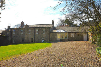
- Price
- £750,000
- Size
- 1 acres
Carr House Great Bavington, Newcastle Upon Tyne NE19, Bavington, Northumberland NE19 England
Added on 28/04/2026Country Home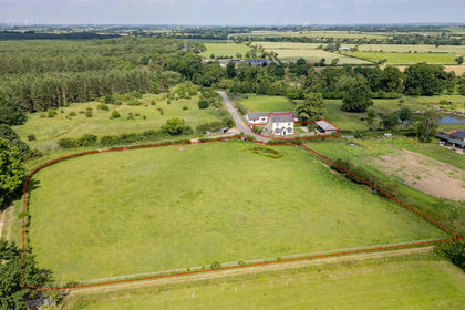
- Price
- Guide Price£750,000
- Size
- 1.9 acres
Added on 08/07/2026Country Home