The Barley House Development Site Lot 1, Woodside, Woolaston, Gloucestershire, GL15
- Land size
- 1.52 acres
Key Features
- Superb location within the settlement of Woolaston
- Prime smallholding and development property with development already commenced with appropriate sign off
- Attractive rural setting with views & good connectivity to the A48
- Planning consent provides for a spacious three-bedroom barn conversion
- Excellent modern and traditional barn and mobile home
- Ringfenced compartment of productive pastureland
- Lot 1 Barn conversion, steel portal framed outbuilding, traditional stone outbuilding & Land extending to 1.52 acres (0.61ha)
- Lot 2 Also available - Two traditional stone barns and pastureland extending to 6.86 acres (2.78 ha)
- Offered as One of Two Lots - Freehold with Vacant Possession
Description
The Barley House Lot 1 comprises an appealing rural smallholding development package with a traditional stone barn with implemented and started planning consent to convert to a three-bedroom residence, an excellent portal framed outbuilding, a mobile home, a further traditional stone buildings and a ringfenced compartment of productive pastureland extending in all to 1.52 acres (0.61 ha). Forming one of Two possible Lots.
Location & Situation
The Barley House Lot 1 enjoys an excellent location and situation positioned a short distance north of the popular Forest of Dean village of Woolaston. Woolaston is a thriving village with many amenities such as Woolaston Primary School, The Netherend Inn, The Rising Sun Free house, Netherend Stores and Post Office, Woolaston Memorial Hall and Woolaston Football Club. Woolaston is serviced by a bus service providing easy access to the towns of Chepstow, Lydney and Cinderford.
The town of Lydney is less than five miles from the property offering an excellent range of amenities including three supermarkets: Aldi, Tesco and Lidl, with a thriving high street with shops, bars, pubs and restaurants, a local library, and a range of schools including Severnbanks Primary School, Lydney C of E School and the Dean Academy. The town also has medical facilities in the form of three doctors’ surgeries and fantastic railway access from Lydney Railway Station with direct trains to Cardiff Central, Cheltenham Spa, Birmingham New Street and Nottingham.
The Barley House enjoys an excellent accessible location 6.9 miles east from the centre of Chepstow, a thriving border town with the picturesque historic Chepstow Castle dating back to the 11th century, the oldest surviving post-Roman stone fortification in Britain and the renowned Chepstow Racecourse. Chepstow has a bustling high street with a mixture of high street chain stores, independent shops and eateries as well as everyday services such as banks, post offices and grocery stores, three distinct shopping areas and a good selection of restaurants and bars. For education, St. John’s on-the-Hill is a co-educational day and boarding preparatory school with all-year round Day Nurseries. There are also primary schools in the area and Chepstow Comprehensive School. An abundance of tourism and recreational activities exist within Chepstow and the wider Wye Valley region.
Monmouth is located just 11.8 miles from the property and boasts excellent schools including Haberdashers’ Monmouth School, Llangattock School Monmouth with Montessori Nursery, a variety of primary schools and Monmouth Comprehensive School. Monmouth also offers an upmarket traditional shopping street, with boutique shops, Waitrose supermarket, M&S Simply Food, The Savoy Theatre and an extensive range of recreational and leisure facilities. An abundance of tourism and recreational activities exist within Monmouth and the wider region.
Gloucester is just 24.7 miles away from the property with all the benefits a city has to offer, such as a bustling Hight Street, Gloucester Quays shopping district, Gloucester University and Gloucester Rugby Club who play in the Rugby Premiership, England’s top division of rugby, as well as in European competitions. Gloucester Cathedral is one of the finest examples of gothic architecture in the UK and Cheltenham Racecourse is just seven miles from the city, host to the world renowned Gold Cup.
The Barley House
Accessed from the west side of Woodside Road a short section of gated drive leads up to the barns and yard. Planning was approved on 23rd March 2021 under planning reference P2044/20/FUL for “Conversion of existing barn buildings to form a new dwelling on land adjacent to Pleasant View, including associated access tracks, car parking and landscaping. Conversion of part of existing farmhouse into annexe associated with Pleasant View.” The development has been commenced. Once completed the property will feature a front hallway with ensuite double bedroom, open plan kitchen/sitting/dining room, shower room and second double bedroom. Stairs from the hallway lead up to the first floor and the third bedroom and bathroom. When completed the property will be a charming spacious barn conversion in an excellent location.
Outbuildings & Mobile Home
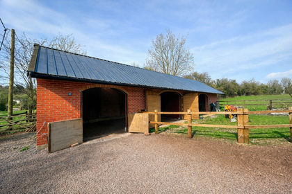
Positioned directly north of the Barley House is a useful monopitched traditional stone storage building. On the western side of the yard is a portal framed block and sheeted building with fibre cement roof which offers an excellent outbuilding to serve the barn conversion.
Positioned adjacent to the portal framed building is a three-bedroom mobile home which is connected to mains electricity providing onsite accommodation for anyone commencing the build.
The barns and buildings adjacent to the yard are all serviced with mains electricity.
All the outbuildings are in good condition with the portal framed barn providing scope for change of use and conversion subject to obtaining the necessary planning permission.
Land
The land at The Barley House Lot 1 is set over two ringfenced filed enclosures of level to gently sloping permanent pasture. The field enclosures could be subdivided further to create paddocks. The land is all permanent pasture, all capable of being grazed and mown for fodder and would provide the perfect grazing for a collection of ponies or pedigree livestock.
No Public Rights of Way cross over the land. The owners of Pleasant View benefit from a right of access over the first part of the drive to the property.
The property is offered as a whole and in two Lots with Lot 1 being the barn with planning, buildings, mobile home, yard and the adjacent field extending to approximately 1.52 acres (0.61 ha). Lot 2 includes two traditional stone barns and land extending to approximately 6.86 acres (2.78 ha).
Key Information
Services: Mains electricity is connected to Lot 1. There is a well within Lot 2 which could provide a private water supply to the property. Mains water is close by and the vendor has obtained quotes for this. Foul drainage is to be to a package treatment plant. Any interested parties are to make, and reply upon their own enquiries, regarding any utility or service connections to the site.
Wayleaves & Easements: The site is sold subject to all existing Wayleaves & Easements that may exist at the date of sale. The owner of Pleasant View benefits from a right of access over the first section of drive to access their property.
Sale Method: The Barley House Development Site is available For Sale by Private Treaty. The Vendor & Selling Agents reserve the right to conclude the sale by any alternative Sale Method.
Development Clawback: A development clawback overage provision will be incorporated into the sale contract to capture any future residential development of the portal framed barn within Lot 1. This will capture 30% of any uplift in value provided by any residential planning consent for a period of 20 years from the date of sale. The overage may be negotiable subject to level of offer.
Local Planning Authority: Forest of Dean District Council. Telephone: 01594 810000.
Viewings: Strictly by appointment with the selling agents.
Directions: From The A48 Main Road heading east at Woolaston turn left onto Netherend Road in the direction of Netherend and Woolaston Common. Proceed on Netherend Road for 0.3 miles then fork left onto Severn View Road in the direction of Woolaston/Woodside. Proceed on Severn View Road for 0.8 miles. The road then turns into Woodside. Proceed for a further 0.3 miles. You will pass a left turn to Woodside Road. Do not take this. The next left will be the driveway to the property. Proceed up the right-hand drive through the black metal gate.
What3Words:
///goodbyes.snowmen.lollipop
Planning Consent: The Planning Consent secured upon the Development Site has been achieved by Apex Architecture Ltd.
Technical design, drawings & architectural work undertaken by Apex Architecture Ltd.
Telephone 01594 516 161 |
Map Location
Property details
- Tenure
- Ask Agent
- Council Tax Band
- Ask Agent
- Date Posted
- 2026-10-22
- Local Authority
- Forest of Dean District Council
Market Value Analysis
Compared with 13 Conversion Land listings in South West England (1+ acres).
Property Brochure
Seen the details? The full report adds the independent checks: planning activity, flood history, heritage and ground.
Utilities & Restrictions
Utilities
- Electricity
- Ask Agent
- Water
- Ask Agent
- Heating
- Ask Agent
- Broadband
- Ask Agent
- Sewerage
- Ask Agent
Rights & Restrictions
- Public Rights of Way
- Ask Agent
- Private Rights of Way
- Ask Agent
- Listed Property
- Ask Agent
- Restrictions
- Ask Agent
Listed status, conservation areas and planning constraints for this location are in the full report.
Property Features
- Accessibility
- Ask Agent
- Parking
- Ask Agent
- Garden
- Ask Agent
Beyond the particulars: planning activity, flood history, heritage and ground risks, checked for this exact spot.
Connectivity
Broadband
Fastest speed available at this postcode
1 Gbps
Gigabit full fibre · available to 93% of premises
Suitable for
- 4K streaming on every screen
- Full-time home working
- Online gaming & big downloads
Mobile signal
Predicted 4G and 5G signal; indoor signal depends on building materials.
Ofcom Connected Nations postcode-level predictions. Speeds and signal are modelled, not measured, and vary between addresses and providers.
Signal is the easy part. Planning activity, flood history and protected designations here are in the full report.
Nearest Schools
Primary
- Woolaston Primary School1.2 milesOfsted: Good
- Ages
- 4 to 11
- Pupils
- 113
- Type
- Community school
- St Briavels Parochial Church of England Primary School2.4 milesOfsted: Good
- Ages
- 3 to 11
- Pupils
- 148
- Type
- Voluntary aided school
- Faith
- Church of England
- Aylburton Church of England Primary School2.4 milesOfsted report card · Feb 2026
- Ages
- 4 to 11
- Pupils
- 68
- Type
- Academy converter
- Faith
- Church of England
- Bream Church of England Primary School3.4 milesOfsted: Good
- Ages
- 4 to 11
- Pupils
- 186
- Type
- Academy sponsor led
- Faith
- Church of England
- Lydney Church of England Community School3.5 milesNo Ofsted rating
- Ages
- 4 to 11
- Pupils
- 199
- Type
- Academy converter
- Faith
- Church of England
Secondary
- The Dean Academy3.3 milesOfsted report card · Jan 2026
- Ages
- 11 to 16
- Pupils
- 816
- Type
- Academy sponsor led
- SGS Berkeley Green UTC4.9 milesOfsted report card · May 2026
- Ages
- 14 to 19
- Pupils
- 391
- Type
- University technical college
- Wyedean School and Sixth Form Centre5 milesNo Ofsted rating
- Ages
- 11 to 18
- Pupils
- 1,024
- Type
- Academy converter
- Five Acres High School7 milesOfsted report card · Jun 2026
- Ages
- 11 to 16
- Pupils
- 786
- Type
- Academy sponsor led
- The Castle School7.3 milesOfsted report card · Mar 2026
- Ages
- 11 to 18
- Pupils
- 1,416
- Type
- Academy converter
Distances are straight-line from the advertised location. Source: the national school registers (DfE, Welsh Government, Scottish Government) and Ofsted.
Schools are just the start: sold prices nearby, planning activity and any flood history are in the full report.
Amenities
Supermarket
GP surgery
Pharmacy
Hospital
Green space
Straight-line distances from the advertised location. Sources: NHS records, Geolytix supermarket locations, OS Open Greenspace and the national trails registers.
The area stacks up? Now check the location itself: planning nearby, protected designations and past flooding.
Getting Around
Nearest station
Nearest bus stop
Typical drive times
Straight-line distances from the advertised location; drive times are typical free-flow times over OpenStreetMap road data, so allow more at peak. Public transport locations from DfT NaPTAN.
Easy to reach matters. So do planning activity, flood history and ground risks: all in the full report.
Flood Risk
Environment Agency open data, checked around the advertised map pin for the listed acreage. Long-term risk counts flood defences; the planning map's flood zones do not. Provided by LandSale, not the listing agent, and not part of the agent's particulars. Risk varies across a holding, so verify before committing.
Rivers and the sea
Planning map: Flood Zone 1.
Surface water
These bandings are the summary. Where this location sits on the flood maps, plus planning activity, heritage and ground risks, is in the full report.
Important notice: Information, maps and tags on this page are drawn from the advertising agent's marketing materials or generated automatically. LandSale has not verified them. Relying on these details is at your own risk, always carry out independent checks before committing to a purchase.
LandSale full disclaimer
Marketing information only - not formal particulars. The details on this website are provided for general guidance and do not constitute an offer or contract. Neither LandSale nor the advertising estate/land agent accepts responsibility for any inaccuracy.
1. Source of information
- Listing content: Core description, asking price, tenure, measurements, photographs and planning history originate from the marketing materials of the advertising estate or land agent. LandSale does not author this content and cannot guarantee its accuracy.
- Automated tags & categorisation: Property type, land-use class, acreage bands and similar labels may be applied by machine-learning models. They are intended as a helpful guide only and may not reflect the property's legal status or permitted use.
- Third-party & enriched data layers: Maps, boundary outlines, planning designations, soil reports, broadband coverage and other environmental or location-based insights are licensed from external suppliers. Such data are supplied “as is", may be incomplete or out of date and are subject to change without notice.
2. Verification required
Prospective purchasers must verify critical matters, including but not limited to planning permission, title boundaries, public rights of way, environmental constraints, acreage, services, access and VAT status, through their own inspections, specialist surveys, legal advisers and the selling agent before relying on the information or entering into any contract.
3. No warranty or liability
LandSale gives no warranty, express or implied, as to the accuracy, completeness or fitness for any particular purpose of the information displayed. LandSale shall not be liable for any loss, damage, cost or expense arising directly or indirectly from any use of or reliance on such information, save where liability may not be excluded by law.
4. Updates & feedback
If you believe any detail on this listing is inaccurate, please let us know. We will investigate and, where appropriate, update the listing or notify the agent.
© LandSale | Version 1.3 - August 2026
Listing agent
Powells, MonmouthSingleton Court Business Park, Wonastow Road, Monmouth, NP25 5JA
View agent profileSimilar properties for sale
- Price
- £500,000
- Size
- 5 acres
Added on 13/10/2026Smallholding
- Price
- Offers in Excess of£500,000
- Size
- 2.2 acres
Added on 08/10/2026Development Land
- Price
- £295,000
- Size
- 0.5 acres
Towy Valley, Close to Llangadog, SA19, Llangadog, Carmarthenshire SA19 Wales
Added on 11/10/2026Conversion Land
- Price
- Guide Price£300,000
- Size
- 24.27 acres
Land & Buildings at Craig Yr Odyn, Trap, Llandeilo, SA19, Llandeilo, Carmarthenshire SA19 Wales
Added on 13/07/2026Smallholding
- Price
- Guide Price£300,000
- Size
- 85.62 acres
Trap, Llandeilo, SA18, Llandeilo, Carmarthenshire SA18 Wales
Added on 07/08/2026Smallholding
- Price
- Offers in Region of£499,995
- Size
- 5.6 acres
Added on 20/02/2026Building Plot
- Price
- Guide Price£295,000
- Size
- 33.03 acres
Added on 03/07/2026Farm
- Price
- Guide Price£475,000
- Size
- 69 acres
Added on 24/09/2026Smallholding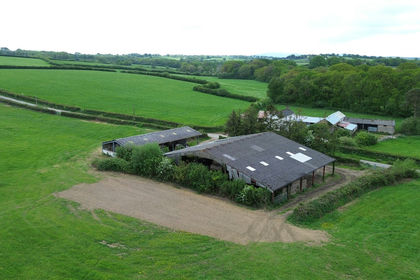
- Price
- Guide Price£380,000
- Size
- 34.68 acres
Station Farm - Lot 4, 34.68 Acres - Bow, Crediton, EX17, Crediton, Devon EX17 England
Added on 05/06/2026Agricultural Land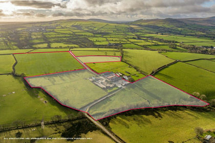
- Price
- £300,000
- Size
- 17.72 acres
Added on 29/01/2026Smallholding