Sylvias, White House, Main Road, Cropthorne, Pershore, Worcestershire, WR10
- Land size
- 3.69 acres
- Bedrooms
- 3
- Bathrooms
- 2
Key Features
- Freehold with Vacant Possession
- Extending to approximately 3.69 acres (1.49 hectares)
- Appealing to lifestyle, horticultural, development, commercial and rural enterprise purchasers
- Approved Class R consent for flexible commercial use of the polytunnels
- Extensive compartment of ring-fenced level pastureland that can be subdivided into paddocks
- Range of polytunnels which have been used for horticulture, with commercial potential
- Double garage with attached fully enclosed outbuildings which could be used for a range of possible uses (STP)
- Extensive three-bedroom residence in need of gentle modernisation
- Excellent connectivity to the towns of Pershore and Evesham and the A46 and M5
- Superb location within the popular settlement of Cropthorne
Description
Sylvias is positioned on the north side of the B4084 Main Road within the settlement of Cropthorne close to the popular towns of Pershore and Evesham.
Pershore 3 miles • Evesham 3.8 miles • Worcester 10.3 miles
Tewkesbury 12.6 miles • Cheltenham 19 miles • Birmingham 38 miles
Bristol 60 miles • London 103 miles • Pershore Railway Station 4.5 miles
Birmingham New Street Station 34.2 miles
Birmingham Airport 36 miles • London Heathrow Airport 91.7 miles
(all distances are approximate)
Location & Situation
Sylvias is well situated within the settlement of Cropthorne in a countryside location with excellent accessibility, positioned on the north side of the B4084 Main Road which connects directly to the towns of Pershore 3 miles to the west and Evesham 3.8 miles to the east. The B4084 provides direct access to the main road networks of the A44 2.6 miles to the north, the A46 3.9 miles to the east and Junction 7 of the M5 just 9 miles to the north-west.
Set on the banks of the River Avon, the town of Pershore, just 3 miles to the west of the property, is a historic Georgian market town and home to the Pershore Plumb Festival, with an excellent array of primary and secondary schools and Pershore College, a horticultural college and part of Warwickshire College. Pershore also offers upmarket traditional shopping streets, with boutique shops, Asda supermarket and an extensive range of bars, pubs, cafes and take-away restaurants. The town benefits from an excellent range of recreational, leisure and sporting facilities and the impressive Pershore Abbey. Pershore Railway station offers a direct railway service to Worcester, Oxford and London Paddington.
The historic Market town of Evesham is just 3.8 miles to the east. Known for its rich history of market gardening and annual river festival Evesham offers an excellent array of primary and secondary schools including Bredon Hill Academy, Harvington CofE School, Prince Henry’s High School and Sedgeberrow CofE First School, all rated outstanding. Evesham offers an excellent range of shopping with boutique and branded stores a Waitrose supermarket, M & S Simply food and an impressive range of pubs, bars and restaurants. The town offers an extensive array of leisure and sport facilities including Evesham Utd FC who play in the Southern Football League Division One South & West, Evesham RFC, and Evesham Cricket Club. Evesham Railway Station is on the Cotswold Line from Oxford to Worcester, Great Malvern and Hereford. There are trains every 45–55 minutes to London Paddington that take approximately 1 hour 45 minutes and trains to Birmingham take around 90 minutes, including a change at Worcester.
The bourgeoning cities of Birmingham and Worcester are close by with populations of 1,149,000 and 103,900 respectively. Both cities provide comprehensive recreational facilities as well as benefitting from multiple schools and universities making them key hubs for education, recreation and commerce with thriving populations. Many businesses operate out of Birmingham and Worcester providing increased demand for commercial premises and office space in the area with excellent road and rail transport links and Birmingham international Airport.
The White House
The property is accessed direct from the north side of the B4084 Main Road within the settlement of Cropthorne. A short section of tarmac drive opens out into a parking area which can accommodate multiple vehicles and also a yard area surrounding the north side of the house. Positioned on the lefthand side of the drive is the residence known as the White House with white painted brick elevations under a pitched tiled roof.
Twin bay windows flank the central front door which opens into the front hallway. To the left-hand side is a spacious sitting room with a bay window to the front and a boarded floor. Opposite the sitting room on the right is the dining room with a bay window to the front and standard window to the side. The dining room features a mock fireplace and parquet flooring. From the dining room a rear hallway provides access to the utility with galley style base units, metal sink, space for washing machine and dryer and cupboard with tiled floor. Next is the kitchen with base and wall units, metal sink tiled floor and single aspect window to the rear. Also accessed from the rear hallway is a downstairs cloakroom and rear utility with external door to the yard.
From the front hallway, stairs lead up to the first floor and the first bedroom, a double with dual aspect windows to the front and side and built in storage room which could be converted to provide a dressing room or ensuite. The second bedroom is also a double with a single aspect window to the front and features the airing cupboard. The third bedroom is a large single or small double bedroom with dual aspect windows to the side and rear. Next is an office with a window to the rear. The office would also be suitable to be used as a nursery. Last is the family bathroom featuring a walk-in shower, bath, wc and wash basin. Due to the layout of the house, the upstairs could be easily remodeled to provide ensuite bathrooms for two of the three bedrooms. The property is in need of gentle modernisation and offers a desirable well laid out family home that any purchaser they can put their own stamp on.
The property is connected to mains water and mains electricity. Heating is by way of a solid fuel biomass boiler which is positioned externally on the western side of the house. The garage also features roof-mounted solar panels which provide a regular Feed in Tariff payment. Foul drainage is to a septic tank.
Outside, the property features a small section of patio and garden to the front which is laid to grass. The property also benefits from a patioed area to the rear which could be used for alfresco dining or barbecues and a rectangular section of lawn. Directly north and west of the house is a tarmac yard area that provides useful additional parking and access to the garages.
Outbuildings & Polytunnels
Positioned to the north-west of the house is a block-built building with monopitched roof featuring twin garages with up & over metal doors. The left-hand garage has historically been used as a coal shed. The building extends out to the north with a fully secure extensive workshop and useful storage shed both with metal double doors and accessed from the eastern side. To the rear of the building is an open fronted shelter. The garages feature roof mounted solar panels. The buildings could be used for a range of possible uses as they provide useful storage but could also be used to house pedigree livestock or stables for anyone with equestrian interests.
Positioned to the east of the block-built building are the polytunnels comprising one small polytunnel and three extensive commercial polytunnels which have historically been utilised for commercial purposes as Sylvias Nursery. The polytunnels have been subject to a recent positive Class R consent to be used for Class B8, storage and Distribution.
Land
The land at Sylvias extends in a rectangular shape to the east and north of the house and buildings and comprises an extensive ring-fenced enclosure of level pastureland which could be subdivided further to provide several paddocks.
All the land is capable of being grazed or mown for fodder or utilised for the purposes of horticulture.
As all the land is easily accessible, level and in good condition it would certainly provide significant appeal to equestrian, agricultural, lifestyle and rural enterprise type purchasers, or anyone with hobby farming interests.
The property also features a drainage pond to the right of the driveway which boarders the front of the property.
In all the house, land and buildings at Sylvias extend to approximately 3.69 acres (1.49 ha).
Planning
The vendors submitted an application to Wychavon District Council for a Class R Change of use - agriculture to flexible commercial use of the Polytunnels under planning reference PP-13148329. “Notification Prior Approval for the change of use of the former nursery buildings for Use Class B8, storage and distribution”. The successful consent was granted on 9th August 2024.
Key Information
Services: Mains water and electricity are connected. Heating is by way of a solid fuel biomass boiler. Roof-mounted solar panels provide a regular Feed in Tariff payment. Foul drainage is to a septic tank. Any interested parties are to make, and reply upon their own enquiries, regarding any utility or service connections to the site.
Wayleaves & Easements: The site is sold subject to all existing Wayleaves & Easements that may exist at the date of sale. Any interested parties are to make, and reply upon their own enquiries, regarding Wayleaves & Easements.
Sale Method: Sylvias is available For Sale by Private Treaty. The Vendor & Selling Agents reserve the right to conclude the sale by any alternative Sale Method.
Local Planning Authority: Wychavon District Council.
Telephone: 01386 565565.
Viewings: Strictly by appointment with the selling agents.
Directions: From Pershore High Street proceed south and east on the B4084 for approximately 2.8 miles. When you pass Nicholas House and Heath Business Park on your right-hand side the property will be on your left-hand side. There is a fenced off drainage pond adjacent to the carpark of the property so please exercise caution when parking your vehicle.
What 3 Words: ///lakeside.available.booster
Map Location
Property details
- Tenure
- Ask Agent
- Council Tax Band
- Ask Agent
- Date Posted
- 2026-10-22
Energy Performance Certificate
Energy Efficiency Rating
Based on UK Energy Performance Certificate standards (EU Directive 2002/91/EC)
Running costs are one side. Planning activity, flood history and ground risks for this location are in the full report.
Property Brochure
Seen the details? The full report adds the independent checks: planning activity, flood history, heritage and ground.
Utilities & Restrictions
Utilities
- Electricity
- Ask Agent
- Water
- Ask Agent
- Heating
- Ask Agent
- Broadband
- Ask Agent
- Sewerage
- Ask Agent
Rights & Restrictions
- Public Rights of Way
- Ask Agent
- Private Rights of Way
- Ask Agent
- Listed Property
- Ask Agent
- Restrictions
- Ask Agent
Listed status, conservation areas and planning constraints for this location are in the full report.
Property Features
- Accessibility
- Ask Agent
- Parking
- Ask Agent
- Garden
- Ask Agent
Beyond the particulars: planning activity, flood history, heritage and ground risks, checked for this exact spot.
Connectivity
Broadband
Fastest speed available at this postcode
900 Mbps
Gigabit full fibre · available to 84% of premises
Suitable for
- 4K streaming on every screen
- Full-time home working
- Online gaming & big downloads
Mobile signal
Predicted 4G and 5G signal; indoor signal depends on building materials.
Ofcom Connected Nations postcode-level predictions. Speeds and signal are modelled, not measured, and vary between addresses and providers.
Signal is the easy part. Planning activity, flood history and protected designations here are in the full report.
Nearest Schools
Primary
- Cropthorne-with-Charlton CofE First School704 metresNo Ofsted rating
- Ages
- 4 to 10
- Pupils
- 94
- Type
- Voluntary controlled school
- Faith
- Church of England
- Fladbury CofE Primary School and Preschool1.3 milesOfsted: Good *
- Ages
- 3 to 11
- Pupils
- 76
- Type
- Voluntary aided school
- Faith
- Church of England
- Elmley Castle CofE First School2 milesOfsted report card · Apr 2026
- Ages
- 5 to 10
- Pupils
- 79
- Type
- Voluntary controlled school
- Faith
- Church of England
- St Andrew's CofE School and Nursery2.2 milesOfsted: Good
- Ages
- 2 to 10
- Pupils
- 348
- Type
- Voluntary controlled school
- Faith
- Church of England
- St Mary's Catholic Primary School2.7 milesNo Ofsted rating
- Ages
- 3 to 11
- Pupils
- 135
- Type
- Academy converter
- Faith
- Roman Catholic
Secondary
- St Egwin's CofE Middle School2.7 milesOfsted: Good *
- Ages
- 10 to 13
- Pupils
- 438
- Type
- Voluntary controlled school
- Faith
- Church of England
- Prince Henry's High School2.9 milesOfsted: Outstanding
- Ages
- 13 to 18
- Pupils
- 1,282
- Type
- Academy converter
- The De Montfort School3.1 milesOfsted: Good
- Ages
- 10 to 18
- Pupils
- 915
- Type
- Academy sponsor led
- Pershore High School3.4 milesOfsted: Requires improvement
- Ages
- 11 to 18
- Pupils
- 1,055
- Type
- Academy converter
- Bredon Hill Academy3.5 milesOfsted: Good *
- Ages
- 10 to 13
- Pupils
- 472
- Type
- Academy converter
* Latest graded judgement covers quality of education only; no overall grade was issued under the 2024-25 inspection framework.
Distances are straight-line from the advertised location. Source: the national school registers (DfE, Welsh Government, Scottish Government) and Ofsted.
Schools are just the start: sold prices nearby, planning activity and any flood history are in the full report.
Amenities
Supermarket
GP surgery
Pharmacy
Hospital
Green space
Straight-line distances from the advertised location. Sources: NHS records, Geolytix supermarket locations, OS Open Greenspace and the national trails registers.
The area stacks up? Now check the location itself: planning nearby, protected designations and past flooding.
Getting Around
Nearest station
Nearest bus stop
Typical drive times
Straight-line distances from the advertised location; drive times are typical free-flow times over OpenStreetMap road data, so allow more at peak. Public transport locations from DfT NaPTAN.
Easy to reach matters. So do planning activity, flood history and ground risks: all in the full report.
Flood Risk
Environment Agency open data, checked around the advertised map pin for the listed acreage. Long-term risk counts flood defences; the planning map's flood zones do not. Provided by LandSale, not the listing agent, and not part of the agent's particulars. Risk varies across a holding, so verify before committing.
Rivers and the sea
Not at the pin: mapped about 30 metres away.
Planning map: Flood Zone 3, about 20 metres away.
Surface water
Not at the pin: mapped about 30 metres away.
These bandings are the summary. Where this location sits on the flood maps, plus planning activity, heritage and ground risks, is in the full report.
Important notice: Information, maps and tags on this page are drawn from the advertising agent's marketing materials or generated automatically. LandSale has not verified them. Relying on these details is at your own risk, always carry out independent checks before committing to a purchase.
LandSale full disclaimer
Marketing information only - not formal particulars. The details on this website are provided for general guidance and do not constitute an offer or contract. Neither LandSale nor the advertising estate/land agent accepts responsibility for any inaccuracy.
1. Source of information
- Listing content: Core description, asking price, tenure, measurements, photographs and planning history originate from the marketing materials of the advertising estate or land agent. LandSale does not author this content and cannot guarantee its accuracy.
- Automated tags & categorisation: Property type, land-use class, acreage bands and similar labels may be applied by machine-learning models. They are intended as a helpful guide only and may not reflect the property's legal status or permitted use.
- Third-party & enriched data layers: Maps, boundary outlines, planning designations, soil reports, broadband coverage and other environmental or location-based insights are licensed from external suppliers. Such data are supplied “as is", may be incomplete or out of date and are subject to change without notice.
2. Verification required
Prospective purchasers must verify critical matters, including but not limited to planning permission, title boundaries, public rights of way, environmental constraints, acreage, services, access and VAT status, through their own inspections, specialist surveys, legal advisers and the selling agent before relying on the information or entering into any contract.
3. No warranty or liability
LandSale gives no warranty, express or implied, as to the accuracy, completeness or fitness for any particular purpose of the information displayed. LandSale shall not be liable for any loss, damage, cost or expense arising directly or indirectly from any use of or reliance on such information, save where liability may not be excluded by law.
4. Updates & feedback
If you believe any detail on this listing is inaccurate, please let us know. We will investigate and, where appropriate, update the listing or notify the agent.
© LandSale | Version 1.3 - August 2026
Listing agent
Powells, MonmouthSingleton Court Business Park, Wonastow Road, Monmouth, NP25 5JA
View agent profileSimilar properties for sale
- Price
- Guide Price£695,000
- Size
- 3 acres
Brittons Lane, Lower Norton, Warwick, Norton Lindsey, Warwickshire CV35 England
Added on 02/07/2026Cottage
- Price
- Guide Price£650,000
- Size
- 4 acres
Falcon Lane, Ledbury, HR8, Munsley, Herefordshire, County of HR8 England
Added on 12/10/2026Smallholding
- Price
- £800,000
- Size
- 6.8 acres
Bodenham, Hereford, Bodenham, Herefordshire, County of HR1 England
Added on 16/10/2026Smallholding- Price
- £725,000
- Size
- 1.85 acres
Bodenham, Hereford, Bodenham, Herefordshire, County of HR1 England
Added on 16/10/2026Farmhouse
- Price
- Guide Price£825,000
- Size
- 20 acres
Neen Savage, Cleobury Mortimer, DY14, Neen Savage, Shropshire DY14 England
Added on 15/04/2026Smallholding
- Price
- £775,000
- Size
- 3.5 acres
Leysters with circa 3 acres and annex, Middleton on the Hill, Herefordshire, County of HR6 England
Added on 31/07/2026Barn Conversion
- Price
- Guide Price£875,000
- Size
- 3.5 acres
Cam Green, Cam, Dursley, GL11, Cam, Gloucestershire GL11 England
Added on 08/10/2026Smallholding
- Price
- Guide Price£640,000
- Size
- 8.35 acres
Ford Bridge, Nr Leominster, Leominster, Herefordshire, County of HR6 England
Added on 28/03/2026Smallholding
- Price
- Offers in Region of£785,000
- Size
- 10 acres
Added on 25/05/2026Smallholding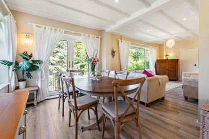
- Price
- Guide Price£750,000
- Size
- 4 acres
High Bank + 4 Acres, Laundry Lane, Newland, Newland, Gloucestershire GL16 England
Added on 22/06/2026Smallholding