Cae Forys Newydd, Aberdaron
- Bedrooms
- 4
- Bathrooms
- 2
Key Features
- Extended Barn Conversion
- Spectacular Views
- Range of Outbuildings
- Spacious Grounds
Description
A stunning barn conversion near the western tip of the Llyn Peninsula, set in open countryside with panoramic coastal and country views. Sympathetically extended and enhanced, the property comprises four bedrooms and a range of outbuildings, set within a plot extending to approximately three quarters of an acre.
The plot rises from the front driveway and wraps around the property to a large lawned area bounded by mature trees and hedges. At the top of the garden stands a traditional summerhouse overlooking the house and enjoying far-reaching views towards Whistling Sands and across to Mynydd Carreg and Anelog.
Extended and restored to a high standard, the property retains its original charm and character through a seamless transition from the original barn to the rear extension. Arranged in an L-shaped configuration, it offers generous living accommodation perfectly suited to modern country living.
Eiddo gwledig trawiadol wedi’i leoli ym mhen draw Ll n, gyda golygfeydd panoramig dros yr arfordir a’r wlad. Mae’r eiddo wedi’i ymestyn a’i foderneiddio i safon uchel, ac mae’n cynnwys pedair ystafell wely ynghyd ag amrywiaeth o adeiladau allanol, o fewn tir sy’n ymestyn dros oddeutu tri chwarter erw.
Mae dreif yn arwain o flaen yr eiddo ac yn lapio o’i amgylch, gan arwain at lawnt helaeth. Ar ben yr ardd mae t haf traddodiadol, sy’n edrych dros yr eiddo ac yn mwynhau golygfeydd pellgyrhaeddol tuag at Draeth Porthor, yn ogystal ag ar draws at Fynydd Carreg ac Anelog.
On entering Cae Forys Newydd, you are welcomed into an open hallway featuring an original staircase. This leads to a fully fitted wet room and pantry, before continuing into the bright and airy kitchen-diner.
The dual-aspect kitchen-diner features an AGA, a country-style fitted kitchen, a picture window and a rear entrance providing access to the courtyard garden. Beyond the kitchen is the living room, complete with fireplace, which leads through to a dining area and rear staircase, positioned in front of the rear ground-floor bedroom, currently used as a music room.
Upstairs, the rear staircase within the modern extension leads to a landing, with bedrooms two and three positioned on either side. Bedroom three is set at a perpendicular angle, creating additional space for a desk. All first-floor rooms benefit from large Velux skylights and useful eaves storage. Beyond the third bedroom, bedroom four leads back to the landing above the front entrance, with the bathroom situated at the far end.
The grounds feature a range of useful buildings, including a detached garage above the property and a custom-built workshop, stores and potting shed. Behind the house is a hidden courtyard garden offering a sheltered suntrap, with a recently constructed greenhouse conveniently located off the kitchen.
Access to the property is via a private shared driveway, with Cae Forys being the original farmhouse of the holding.
The accommodation comprises:
Ground Floor:
Entrance Porch - 1.53m x 1.58m
Hallway - 1.86m x 3.91m
Stairs to 1st Floor.
Wet Room - 2.07m x 2.65m
Pantry - 1.07m x 2.16m
Provision for White-goods.
Kitchen Diner - 3.87m x 4.64m
Aga Range, Fitted Kitchen.
Living Room - 4.19m x 4.77m
Fireplace with Stove.
Dining Area - 2.41m x 4.53m
Bedroom 1 - 3.20m x 4.50m
Presently a Music Room & Office.
First Floor:
Landing (Front) - 1.16m x 2.40m
Bathroom - 2.40m x 3.0m
Bedroom 4 - 2.40m x 4.84m
Bedroom 3 - 4.23m x 4.60m (max)
Landing (Rear) - 2.16m x 2.47m
Bedroom 2 - 2.47m x 3.20m
Each first floor bedroom features a Velux window.
The house is constructed of traditional stone elevations under slate roof.
Outbuildings comprise:
Garage - 3.64m x 8.53m
Masonry Construction, Power with Consumer Unit.
Outbuilding 'L' Shaped divided to 3 rooms - 5.66m x 4.35m (max)
Custom made timber frame under metal roof.
Summer House - 2.39m x 3.53m
Greenhouse - 1.60m x 3.0m
Lean-to off Kitchen wall.
Double Glazed Windows
Oil Fired Central Heating, Mains Services and Private Drainage
EPC: E I Council Tax Band: D
Important Information:
Directions:
On entering Aberdaron, approach the 20 mph zone at Cwt Chwarel and bear left towards Uwchmynydd. Continue past the Bro Hywyn estate towards Deunant Church. Opposite the church, turn right and follow the single-track road for approximately half a mile, passing Deuglawdd Farm. The driveway to Cae Forys Newydd is the next turning on the right.
Tenure:
We understand that the tenure of this property is Freehold.
Method of Sale:
The property is offered for sale by Private Treaty.
Boundaries:
Purchaser shall be deemed to have full knowledge of all boundaries and neither the Vendor nor Vendors Agents are responsible for defining the boundaries or ownership thereof.
Planning:
The property is sold subject to any existing or other statutory notice or which may come into force in the future. Purchasers should make their own enquiries into any designations.
Easements, Wayleaves and Rights of Way:
The land is sold subject to all the benefits of all wayleaves, easements, right of way and third party rights, whether mentioned in the particulars or not.
Viewing:
Strictly by appointment only.
LWH and their clients give notice that:- They do not have the authority to make or give any representations or warranties in relation to the property. These particulars do not form part of any offer or contract and must not be relied upon as statements or representations of fact. Any areas, measurements or distances are approximate. The text and plans are for guidance only and are not necessarily comprehensive. It should not be assumed that the property has all necessary planning, building regulations or other consents and the agents have not tested any services, equipment or facilities. Purchasers must satisfy themselves by inspection or otherwise.
Map Location
Property details
- Tenure
- Ask Agent
- Council Tax Band
- Ask Agent
- Date Posted
- 2026-09-16
Energy Performance Certificate
Energy Efficiency Rating
Based on UK Energy Performance Certificate standards (EU Directive 2002/91/EC)
View official EPC certificate ↗
Running costs are one side. Planning activity, flood history and ground risks for this location are in the full report.
Utilities & Restrictions
Utilities
- Electricity
- Ask Agent
- Water
- Ask Agent
- Heating
- Ask Agent
- Broadband
- Ask Agent
- Sewerage
- Ask Agent
Rights & Restrictions
- Public Rights of Way
- Ask Agent
- Private Rights of Way
- Ask Agent
- Listed Property
- Ask Agent
- Restrictions
- Ask Agent
Listed status, conservation areas and planning constraints for this location are in the full report.
Property Features
- Accessibility
- Ask Agent
- Parking
- Parking Available
- Garden
- Garden
Beyond the particulars: planning activity, flood history, heritage and ground risks, checked for this exact spot.
Connectivity
Broadband
Fastest speed available at this postcode
33 Mbps
Superfast · available to 50% of premises
Suitable for
- HD streaming
- Video calls
- Web & social
Mobile signal
Outdoor predictions; indoor signal depends on building materials.
Ofcom Connected Nations postcode-level predictions. Speeds and signal are modelled, not measured, and vary between addresses and providers.
Signal is the easy part. Planning activity, flood history and protected designations here are in the full report.
Nearest Schools
Primary
- Ysgol Crud-Y-Werin0.8 miles
- Pupils
- 55
- Type
- Nursery, Infants & Juniors
- Language
- Welsh medium school / provision (including transitional)
- Ysgol Pont Y Gof5.4 miles
- Pupils
- 101
- Type
- Nursery, Infants & Juniors
- Language
- Welsh medium school / provision (including transitional)
- Ysgol Gynradd Tudweiliog6.6 miles
- Pupils
- 51
- Type
- Nursery, Infants & Juniors
- Language
- Welsh medium school / provision (including transitional)
- Ysgol Sarn Bach7.8 miles
- Pupils
- 24
- Type
- Nursery, Infants & Juniors
- Language
- Welsh medium school / provision (including transitional)
- Ysgol Foel Gron8 miles
- Pupils
- 29
- Type
- Nursery, Infants & Juniors
- Language
- Welsh medium school / provision (including transitional)
Secondary
- Ysgol Botwnnog5.7 miles
- Pupils
- 469
- Type
- Secondary (ages 11-16)
- Language
- Welsh medium school / provision (including transitional)
- Ysgol Glan y Mor13 miles
- Pupils
- 474
- Type
- Secondary (ages 11-16)
- Language
- Welsh medium school / provision (including transitional)
- Ysgol Dyffryn Nantlle24 miles
- Pupils
- 397
- Type
- Secondary (ages 11-19)
- Language
- Welsh medium school / provision (including transitional)
- Ysgol Ardudwy25 miles
- Pupils
- 331
- Type
- Secondary (ages 11-16)
- Language
- Welsh medium school / provision (including transitional)
- Ysgol Eifionydd25 miles
- Pupils
- 373
- Type
- Secondary (ages 11-16)
- Language
- Welsh medium school / provision (including transitional)
Distances are straight-line from the advertised location. Source: the national school registers (DfE, Welsh Government, Scottish Government) and Ofsted.
Schools are just the start: sold prices nearby, planning activity and any flood history are in the full report.
Amenities
Supermarket
GP surgery
Pharmacy
Straight-line distances from the advertised location. Sources: NHS records, Geolytix supermarket locations, OS Open Greenspace and the national trails registers.
The area stacks up? Now check the location itself: planning nearby, protected designations and past flooding.
Getting Around
Nearest station
Nearest bus stop
Typical drive times
Straight-line distances from the advertised location; drive times are typical free-flow times over OpenStreetMap road data, so allow more at peak. Public transport locations from DfT NaPTAN.
Easy to reach matters. So do planning activity, flood history and ground risks: all in the full report.
Flood Risk
From Natural Resources Wales flood map open data, checked around the advertised map pin and allowing for the listed acreage where known. This summary comes from LandSale, the advertising platform, not from the listing agent, and is not part of the agent's particulars. Risk can vary across a single holding, so verify anything critical through your own searches before committing.
Rivers and the sea
Surface water
The detail behind these bandings
The full report pinpoints where this location sits on the flood maps, and runs the deeper checks that usually only surface after an offer.
- Exact flood zones & annual chances (included in the full report)
- Any recorded past flooding (included in the full report)
- Planning activity nearby (included in the full report)
- Heritage & conservation (included in the full report)
- Protected nature designations (included in the full report)
- Ground risks (included in the full report)
- Sold prices nearby (included in the full report)
£14.99 · one-off purchase
By LandSale, the platform. Not provided by the listing agent. Ready in about a minute.
Important notice: Information, maps and tags on this page are drawn from the advertising agent's marketing materials or generated automatically. LandSale has not verified them. Relying on these details is at your own risk, always carry out independent checks before committing to a purchase.
LandSale full disclaimer
Marketing information only - not formal particulars. The details on this website are provided for general guidance and do not constitute an offer or contract. Neither LandSale nor the advertising estate/land agent accepts responsibility for any inaccuracy.
1. Source of information
- Listing content: Core description, asking price, tenure, measurements, photographs and planning history originate from the marketing materials of the advertising estate or land agent. LandSale does not author this content and cannot guarantee its accuracy.
- Automated tags & categorisation: Property type, land-use class, acreage bands and similar labels may be applied by machine-learning models. They are intended as a helpful guide only and may not reflect the property's legal status or permitted use.
- Third-party & enriched data layers: Maps, boundary outlines, planning designations, soil reports, broadband coverage and other environmental or location-based insights are licensed from external suppliers. Such data are supplied “as is", may be incomplete or out of date and are subject to change without notice.
2. Verification required
Prospective purchasers must verify critical matters, including but not limited to planning permission, title boundaries, public rights of way, environmental constraints, acreage, services, access and VAT status, through their own inspections, specialist surveys, legal advisers and the selling agent before relying on the information or entering into any contract.
3. No warranty or liability
LandSale gives no warranty, express or implied, as to the accuracy, completeness or fitness for any particular purpose of the information displayed. LandSale shall not be liable for any loss, damage, cost or expense arising directly or indirectly from any use of or reliance on such information, save where liability may not be excluded by law.
4. Updates & feedback
If you believe any detail on this listing is inaccurate, please let us know. We will investigate and, where appropriate, update the listing or notify the agent.
© LandSale | Version 1.3 - August 2026
Listing agent
Tir Ac Eiddo LWH Land and Property CYF, Pwllheli
27 Penlan Street, Pwllheli, LL53 5DE
Contact Tir Ac Eiddo LWH Land and Property CYF, Pwllheli
27 Penlan Street, Pwllheli, LL53 5DE
View agent profileSimilar properties for sale
- Price
- £595,000
- Size
- 6 acres
Added on 28/01/2026House with Land
- Price
- £415,000
- Size
- 2.7 acres
Added on 29/01/2026House with Land
- Price
- Guide Price£550,000
- Size
- 6.1 acres
Tudweiliog, Pwllheli, Gwynedd, LL53, Tudweiliog, Gwynedd LL53 Wales
Added on 05/03/2026Smallholding Added on 02/05/2026Cottage
- Price
- £435,000
- Size
- 0.4 acres
Ysgubor Hen, Cilan, Nr Abersoch, LL53, Llanengan, Gwynedd LL53 Wales
Added on 21/05/2026Barn Conversion
- Price
- £445,000
- Size
- 3 acres
Added on 25/08/2026House with Land
- Price
- £449,000
- Size
- 2.9 acres
Added on 29/01/2026House with Land
- Price
- Guide Price£595,000
- Size
- 10.02 acres
Lon Tan Y Bryn, Morfa Nefyn, Pwllheli, Gwynedd, LL53, Nefyn, Gwynedd LL53 Wales
Added on 21/05/2026House with Land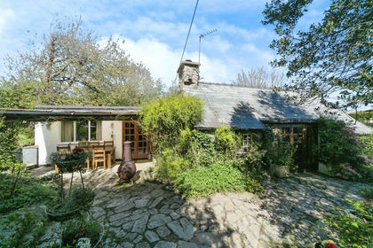
- Price
- £430,000
- Size
- 11.5 acres
Penrhos, Pwllheli, Gwynedd, LL53, Llannor, Gwynedd LL53 Wales
Added on 29/01/2026House with Land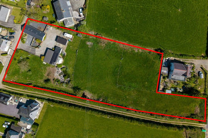
- Price
- £460,000
- Size
- 1.6 acres
Added on 01/02/2026Multiple Dwelling Property