Grundisburgh Road, Clopton
- Land size
- 3.8 acres
- Bedrooms
- 7
- Bathrooms
- 3
Description
“A distinguished and storied home with an orchard and a pretty kitchen garden”
This remarkable 17th-century house is a former rectory that lies in the picturesque Suffolk village of Clopton. The home is a picture of classical detailing inside and out, whilst providing exceptional levels of comfort, the result of years of sensitive renovation works under current ownership. High-quality materials have been incorporated throughout, celebrating a transitional style in which the traditional meets the contemporary. Set within 3.8 acres of private grounds, including an enchanting, partly walled garden and whimsical woodland, the house occupies a delightfully peaceful setting.
Setting the Scene
The Old Rectory dates to the early 17th century, with extensive alterations and additions over the subsequent centuries, lending the house a distinctive composite structure. Officially listed in 1966, the home presents a timber-framed foundation, colour-washed stucco render (an ashlar imitation), a patinated tiled roof, and two original gabled wings. It incorporates many of the period’s architectural inclinations, from rows of four-over-four sash windows to chamfered ceiling beams within.
The Grand Tour
A sweeping tree-lined gravel driveway defines the approach to the house. At its centre, a Greek-revival door surround with Doric columns and a moulded entablature forms a grand entrance point. The front door has a glazed upper panel and two recessed lower panels, and it opens to a spacious entrance hall with local Suffolk flooring.
From here, the plan follows a tripartite layout: the central part of the house consists of three spacious reception rooms, intimate seating areas in the east wing, and a kitchen in the west wing. Suffolk pammet tiles tun throughout the ground floor hall.
A new shaker-style kitchen has been painted duck-egg blue, ‘Danbury' by Sanderson and counters are varnished hardwood. A light-coloured dado panel splashback frames a cream AGA range cooker, and pammet tiles run underfoot. Sash and casement windows at either side draw natural light deep into the room, and exceptionally generous utility and larder rooms sit adjacent with an original bread oven.
To the centre and right are a formal dining room, a drawing room, a library, and two sitting rooms. Original, working, Georgian shutters grace the sash windows in the main reception rooms. Original fireplaces have been fitted with working wood burners to warm the spaces, and a considered selection of paints washes the walls. The formal early 19th-century drawing room overlooks the walled garden and village church.
A sweeping staircase with a sisal runner winds up to the first floor, where six bedrooms are arranged along an open, lateral corridor, with original 17th-century hardwood floors and soothing paint tones. The principal bedroom, with original oak flooring, occupies the upper east wing, with an adjoining bathroom complete with a freestanding bathtub, a walk-in shower, and exposed beams. 'Witches marks' known as hexafoils can be found on one of the beams. A spacious shared bathroom lies off the landing with marble tiles underfoot, a claw-foot bath, and a specious walk-in shower.
The staircase continues to the attic level, which has a room overlooking the garden that could double as an additional bedroom or a crafting room, and an adjoining room that provides generous storage. Marvellous views stretch across the garden and the treetops beyond. There is also a cellar that can be used for further storage or could make an excellent wine cellar.
The Great Outdoors
A strong connection is fostered with the home's enchanting rear garden. The garden is composed of a combination of lawn, pond area, an ornamental cherry tree that looks spectacular in late Spring and mature fruit trees. It is grounded by a mature two acre woodland, while a walled kitchen garden has been beautifully landscaped with raised beds filled with produce and flowering perennials. A paved terrace provides a peaceful outdoor seating area perfect for alfresco entertaining. The garden is peppered with historic outbuildings, including a coach house, old stables, and a potting shed, and an orchard stocked with apple, pear, plum, quince, greengage and damson fruit trees.
Out and About
The home is situated in a peaceful area of rural Suffolk on the edges of Clopton and Grundisburgh. Grundisburgh centres around a classic village green and stream, featuring a local grocery store, primary school, and The Dog at Grundisburgh, a popular local pub known for its wood-fired pizzas and local ales.
A 10-minute drive east reaches Woodbridge, a thriving historic market town along the River Deben with a bustling high street filled with independent boutiques, artisan bakeries, restaurants, and the iconic Woodbridge Tide Mill. Nearby are the National Trust site at Sutton Hoo and the broader Suffolk Heritage Coast, within easy reach for coastal walks.
The area is well served by schools in both the state and independent sector. Woodbridge School, Framlingham College and Ipswich School are all highly regarded, with Grundisburgh primary school, Woodbridge primary school and Farlingaye High School also close by.
For transport, mainline rail services run directly from Ipswich railway station (around a 20-minute drive away) into London Liverpool Street in approximately 70 minutes, while local train links are also accessible from nearby Woodbridge and Melton stations.
Council Tax Band: G
Map Location
Property details
- Tenure
- Freehold
- Council Tax Band
- G
- Date Posted
- 2026-08-26
Market Value Analysis
Compared with 1,142 Homes with Land listings in East Anglia (1+ acres).
Energy Performance Certificate
Energy Efficiency Rating
Based on UK Energy Performance Certificate standards (EU Directive 2002/91/EC)
Running costs are one side. Planning activity, flood history and ground risks for this location are in the full report.
Utilities & Restrictions
Utilities
- Electricity
- Mains
- Water
- Mains
- Heating
- Oil Heating, Wood Burner
- Broadband
- Full Fibre (FTTP)
- Sewerage
- Septic Tank / Private
Rights & Restrictions
- Public Rights of Way
- Ask Agent
- Private Rights of Way
- Ask Agent
- Listed Property
- Yes
- Restrictions
- Yes
Listed status, conservation areas and planning constraints for this location are in the full report.
Property Features
- Accessibility
- Ask Agent
- Parking
- Garage, Off-Street Parking
- Garden
- Garden
Beyond the particulars: planning activity, flood history, heritage and ground risks, checked for this exact spot.
Connectivity
Broadband
Fastest speed available at this postcode
1.8 Gbps
Gigabit full fibre
Suitable for
- 4K streaming on every screen
- Full-time home working
- Online gaming & big downloads
Mobile signal
Predicted 4G and 5G signal; indoor signal depends on building materials.
Ofcom Connected Nations postcode-level predictions. Speeds and signal are modelled, not measured, and vary between addresses and providers.
Signal is the easy part. Planning activity, flood history and protected designations here are in the full report.
Nearest Schools
Primary
- Grundisburgh Primary School1.2 milesNo Ofsted rating
- Ages
- 5 to 11
- Pupils
- 169
- Type
- Community school
- Otley Primary School2.1 milesOfsted: Good *
- Ages
- 4 to 11
- Pupils
- 51
- Type
- Community school
- Witnesham Primary School2.3 milesOfsted: Good
- Ages
- 4 to 11
- Pupils
- 90
- Type
- Community school
- Bealings School2.9 milesOfsted: Good
- Ages
- 4 to 11
- Pupils
- 104
- Type
- Community school
- Charsfield Church of England Primary School3.2 milesNo Ofsted rating
- Ages
- 4 to 11
- Pupils
- 34
- Type
- Academy converter
- Faith
- Church of England
Secondary
- Farlingaye High School3.1 milesOfsted report card · May 2026
- Ages
- 11 to 18
- Pupils
- 1,861
- Type
- Academy converter
- Kesgrave High School4.1 milesOfsted: Good
- Ages
- 11 to 18
- Pupils
- 1,875
- Type
- Academy converter
- Northgate High School4.6 milesOfsted: Good *
- Ages
- 11 to 18
- Pupils
- 1,750
- Type
- Community school
- St Alban's Catholic High School4.7 milesOfsted: Good
- Ages
- 11 to 18
- Pupils
- 967
- Type
- Academy converter
- Faith
- Roman Catholic
- Ormiston Endeavour Academy5.3 milesNo Ofsted rating
- Ages
- 11 to 16
- Pupils
- 793
- Type
- Academy sponsor led
* Latest graded judgement covers quality of education only; no overall grade was issued under the 2024-25 inspection framework.
Distances are straight-line from the advertised location. Source: the national school registers (DfE, Welsh Government, Scottish Government) and Ofsted.
Schools are just the start: sold prices nearby, planning activity and any flood history are in the full report.
Amenities
Supermarket
GP surgery
Pharmacy
Hospital
Straight-line distances from the advertised location. Sources: NHS records, Geolytix supermarket locations, OS Open Greenspace and the national trails registers.
The area stacks up? Now check the location itself: planning nearby, protected designations and past flooding.
Getting Around
Nearest station
Nearest bus stop
Typical drive times
Straight-line distances from the advertised location; drive times are typical free-flow times over OpenStreetMap road data, so allow more at peak. Public transport locations from DfT NaPTAN.
Easy to reach matters. So do planning activity, flood history and ground risks: all in the full report.
Flood Risk
Environment Agency open data, checked around the advertised map pin for the listed acreage. Long-term risk counts flood defences; the planning map's flood zones do not. Provided by LandSale, not the listing agent, and not part of the agent's particulars. Risk varies across a holding, so verify before committing.
Rivers and the sea
Not at the pin: mapped about 60 metres away.
Planning map: Flood Zone 3, about 60 metres away.
Surface water
Not at the pin: mapped about 40 metres away.
These bandings are the summary. Where this location sits on the flood maps, plus planning activity, heritage and ground risks, is in the full report.
Important notice: Information, maps and tags on this page are drawn from the advertising agent's marketing materials or generated automatically. LandSale has not verified them. Relying on these details is at your own risk, always carry out independent checks before committing to a purchase.
LandSale full disclaimer
Marketing information only - not formal particulars. The details on this website are provided for general guidance and do not constitute an offer or contract. Neither LandSale nor the advertising estate/land agent accepts responsibility for any inaccuracy.
1. Source of information
- Listing content: Core description, asking price, tenure, measurements, photographs and planning history originate from the marketing materials of the advertising estate or land agent. LandSale does not author this content and cannot guarantee its accuracy.
- Automated tags & categorisation: Property type, land-use class, acreage bands and similar labels may be applied by machine-learning models. They are intended as a helpful guide only and may not reflect the property's legal status or permitted use.
- Third-party & enriched data layers: Maps, boundary outlines, planning designations, soil reports, broadband coverage and other environmental or location-based insights are licensed from external suppliers. Such data are supplied “as is", may be incomplete or out of date and are subject to change without notice.
2. Verification required
Prospective purchasers must verify critical matters, including but not limited to planning permission, title boundaries, public rights of way, environmental constraints, acreage, services, access and VAT status, through their own inspections, specialist surveys, legal advisers and the selling agent before relying on the information or entering into any contract.
3. No warranty or liability
LandSale gives no warranty, express or implied, as to the accuracy, completeness or fitness for any particular purpose of the information displayed. LandSale shall not be liable for any loss, damage, cost or expense arising directly or indirectly from any use of or reliance on such information, save where liability may not be excluded by law.
4. Updates & feedback
If you believe any detail on this listing is inaccurate, please let us know. We will investigate and, where appropriate, update the listing or notify the agent.
© LandSale | Version 1.3 - August 2026
Similar properties for sale
- Price
- Guide Price£1,650,000
- Size
- 8 acres
Greatwood House, Great Blakenham, Suffolk, IP6, Great Blakenham, Suffolk IP6 England
Added on 08/08/2026House with Land
- Price
- £1,250,000
- Size
- 8.7 acres
Added on 23/05/2026Farmhouse
- Price
- £1,425,000
- Size
- 4.5 acres
Rectory Road, Blaxhall, Woodbridge, Blaxhall, Suffolk IP12 England
Added on 28/09/2026Country Home
- Price
- Guide Price£1,650,000
- Size
- 3.6 acres
High Road, Great Finborough, Stowmarket, Suffolk, IP14, Great Finborough, Suffolk IP14 England
Added on 13/08/2026Country Home
- Price
- Guide Price£1,500,000
- Size
- 5 acres
Long Road East, Dedham, Colchester, Essex, CO7, Dedham, Essex CO7 England
Added on 29/01/2026Country Home
- Price
- Guide Price£1,400,000
- Size
- 10 acres
The Rookery, Stratford Road, Dedham, Essex, CO7, Dedham, Essex CO7 England
Added on 29/01/2026Farmhouse
- Price
- Guide Price£1,350,000
- Size
- 1.5 acres
Added on 29/01/2026Country Home
- Price
- Guide Price£1,500,000
- Size
- 6.7 acres
Added on 11/09/2026House with Land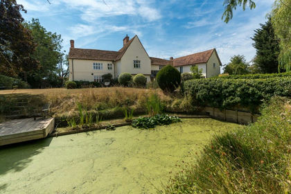
- Price
- £1,500,000
- Size
- 1.2 acres
Wood Hall, Wormingford, Colchester, Essex, CO6, Wormingford, Essex CO6 England
Added on 12/08/2026Country Home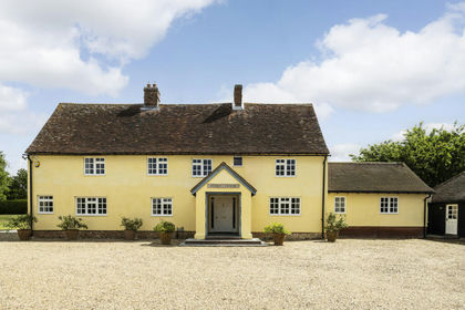
- Price
- Guide Price£1,200,000
- Size
- 2 acres
Added on 22/06/2026Country Home