Fressingfield, Suffolk
- Land size
- 1.5 acres
- Bedrooms
- 4
- Bathrooms
- 2
Key Features
- Immaculate versatile accommodation
- In the unspoilt Waveney Valley
- Convenient peaceful setting
- Local intercity links to London and Norwich
- Landscaped parkland grounds of 1.5 acres
- Recently renovated and refurbished
- Close to the Suffolk Heritage Coast
- Chain free
Description
A unique contemporary country house of imposing design, in the coveted Waveney Valley, close to the Suffolk Heritage Coast. All in 1.5-acres.
The Bower House is a fine example of a unique architecturally designed contemporary country house. Located within the unspoilt rural vistas of the Waveney Valley in Suffolk, this is an area distinct for the majesty of its rolling landscapes, its medieval heritage and historic villages. Designed by architects Poole & Prattle in 2002 this elegant statement house combines an impressive architectural profile, using clever palettes of glass and steel, while internally providing a series of dynamic free-flowing living spaces, cleverly fusing open-plan flow with contemporary nuances of warmth, light and sophistication.
Recently, this versatile property has been the subject of a considerable renovation project by the current owners, and every possible improvement has been carefully considered and executed by local specialist firms.
Extending to around 2,700sq ft, every aspect of the property enjoys a wonderfully light and verdant outlook onto a mature tree-scape of peaceful grounds, clipped curved hedges and an abundance of landscaped herbaceous flower borders, all mirroring the use of the curved vernacular of the house, and affording complete privacy.
Within the tailored architectural perspectives and floor to ceiling windows throughout, the spacious airy accommodation in the east wing is accessed via a pooled quadrangle and comprises: a wide entrance hall and bespoke fitted cupboards, leading to an expansive open-plan ‘U’-shaped living area with underground heating. This luxurious space displays an elegant sitting room with expansive vaulted ceiling, large levels of natural light and Heta Scanline clean-burning stove. The large dining area sits between the sitting room and kitchen, with wide floor to ceiling double glass doors to the morning garden terrace to the east.
Ahead a stylish statement kitchen, designed by Mulberry Kitchens of Beccles, displays a range of sleek modern refinements, including Miele appliances and a 4-oven electric/energy-efficient eControl Aga. Leading from the kitchen, the utility room comprises a separate curved-walled cloakroom and bespoke utility cupboards with fitted storage and linen cupboard, plumbing for washing machine and tumble dryer and eaves storage above.
The impressive first-floor principal bedroom, with magnificent open gallery, looks across to arched ceilings and windows to the south and east. There are two large walk-in wardrobes, accompanied by further eaves storage provisions, and an arched opening to a luxurious bath and shower room, with stylish coordinating fittings from Roca, Matki and Hansgrohe, with floor to ceiling glazed doors opening onto a treetop balcony with views overlooking the gardens and fields beyond.
The west wing of The Bower House provides versatile accommodation, whether for family, entertaining or guest quarters and affords privacy and yet remains a fully integrated part of the home. This adaptable part of the house presently comprises a light and sunny family/sitting room, with bespoke fitted cupboards, and double floor to ceiling glazed doors over-looking a lushly planted rear quadrangle. There is a large sleek shower room with Matki and Roca fittings, and two further double bedrooms with bespoke fitted cupboards. A secondary fitted utility/prep/laundry kitchen, is currently used as an adjunct to the main house with further storage, built-in appliances, and views and access to the front quadrangle and gardens via wide floor to ceiling glazed doors.
Outside
The Bower House is approached via a tranquil Suffolk countryside lane, set well back from the road, via its own private driveway and grounds, surrounded on each side by mature woodland. Imposing double gates lead to an expansive inner parking area and formal front quadrangle. The grounds extend to around 1.5 acres, and offer a quiet and secluded environment to the house. A haven for local wildlife and birds, this established parkland setting once housed the studio of the late Tristram Cary, composer and pioneer of electronic music, and continues to provide an intimate backdrop for the house. In addition, there is a garden shed and wood store to the rear of the property within its own hedged utilitarian area.
Services
Mains water and electricity • private Klargester treatment plant • Oil-fired heating (incl. underfloor) • Council Tax Band ‘F’ • EPC ‘D’ • Broadband: Ofcom suggest Superfast 40Mb available • Mobile: Ofcom suggest all providers likely.
Location
The Bower House sits in the traditional Suffolk rolling landscapes of the pastures and plains of the unique Waveney Valley forming part of The Suffolk Broads National Park, and equidistant between the historic villages of Fressingfield and Metfield. Conveniently placed between Diss and Southwold, lies the splendour of the Suffolk Coast and Heaths Area of Natural Outstanding Beauty, including the renowned coastal destinations of Southwold, Walberswick and Aldeburgh, which lie a short drive to the east.
To the south lies the market town of Framlingham, its Castle and the well-regarded Independent School, Framlingham College, both close to the vibrant former medieval port of Woodbridge, with excellent shopping and dining. To the west and a 20-minute drive to the market town of Diss, there are frequent direct Intercity links by train to Norwich (20 mins) and London Liverpool Street (80 mins). Norwich and Stansted International Airports are both within easy reach.
Located a mile or so along picturesque country lanes to the east and west are the historic thriving villages of Fressingfield and Metfield, each with excellent facilities and active village community services. Fressingfield, hosts a vineyard, a village shop, medical centre, nursery/primary school, sports centre & tennis courts. Sandcroft Hall, run by the 14th century and thriving Parish Church of St Peter & St Paul, serves as the village hall. Neighbouring the church is The Swan Inn, and critically acclaimed restaurant, The Fox & Goose.
The smaller equally flourishing village of Metfield, benefits from a bus service, community village shop, village hall, local garage, plant nursery and café. The active 12th century church of St John the Baptist, founded in 1155 within the auspices of the nearby Mendham Priory, further exemplifies the historical roots and beauty of the area.
ANTI-MONEY LAUNDERING (AML) AND ID CHECKS - In order to comply with current legislation, in the event that you make an acceptable offer and before solicitors are instructed, we must complete a number of checks for which you will be charged £30 including VAT per person (a company, trust, or similar will be charged a one-off fee of £75 including VAT).
Map Location
Property details
- Tenure
- Freehold
- Council Tax Band
- TBC
- Date Posted
- 2026-01-29
Market Value Analysis
Compared with 1,144 Homes with Land listings in East Anglia (1+ acres).
Energy Performance Certificate
Energy Efficiency Rating
Based on UK Energy Performance Certificate standards (EU Directive 2002/91/EC)
Running costs are one side. Planning activity, flood history and ground risks for this location are in the full report.
Utilities & Restrictions
Utilities
- Electricity
- Ask Agent
- Water
- Ask Agent
- Heating
- Ask Agent
- Broadband
- Ask Agent
- Sewerage
- Ask Agent
Rights & Restrictions
- Public Rights of Way
- Ask Agent
- Private Rights of Way
- Ask Agent
- Listed Property
- Ask Agent
- Restrictions
- Ask Agent
Listed status, conservation areas and planning constraints for this location are in the full report.
Property Features
- Accessibility
- Ask Agent
- Parking
- Parking Available
- Garden
- Garden
Beyond the particulars: planning activity, flood history, heritage and ground risks, checked for this exact spot.
Connectivity
Broadband
Fastest speed available at this postcode
1.8 Gbps
Gigabit full fibre
Suitable for
- 4K streaming on every screen
- Full-time home working
- Online gaming & big downloads
Mobile signal
Predicted 4G and 5G signal; indoor signal depends on building materials.
Ofcom Connected Nations postcode-level predictions. Speeds and signal are modelled, not measured, and vary between addresses and providers.
Signal is the easy part. Planning activity, flood history and protected designations here are in the full report.
Nearest Schools
Primary
- Fressingfield Church of England Primary School2.2 milesNo Ofsted rating
- Ages
- 4 to 11
- Pupils
- 91
- Type
- Academy converter
- Faith
- Church of England
- Mendham Primary School3.1 milesNo Ofsted rating
- Ages
- 3 to 11
- Pupils
- 57
- Type
- Academy converter
- All Saints Church of England Primary School, Laxfield3.9 milesOfsted: Outstanding *
- Ages
- 4 to 11
- Pupils
- 97
- Type
- Academy converter
- Faith
- Church of England
- The Harleston Sancroft Academy (a 3-16 Church of England School)4.1 milesOfsted: Good *
- Ages
- 3 to 16
- Pupils
- 824
- Type
- Academy converter
- Faith
- Church of England
- Stradbroke Church of England Primary School4.6 milesOfsted: Good
- Ages
- 4 to 11
- Pupils
- 112
- Type
- Academy converter
- Faith
- Church of England
Secondary
- The Harleston Sancroft Academy (a 3-16 Church of England School)4.1 milesOfsted: Good *
- Ages
- 3 to 16
- Pupils
- 824
- Type
- Academy converter
- Faith
- Church of England
- Stradbroke High School4.8 milesNo Ofsted rating
- Ages
- 11 to 16
- Pupils
- 353
- Type
- Academy converter
- Bungay High School7 milesOfsted report card · Mar 2026
- Ages
- 11 to 18
- Pupils
- 922
- Type
- Academy converter
- Thomas Mills High School & Sixth Form9 milesOfsted: Good
- Ages
- 11 to 18
- Pupils
- 1,056
- Type
- Academy converter
- Hartismere School9.9 milesOfsted: Good *
- Ages
- 11 to 18
- Pupils
- 1,062
- Type
- Academy converter
* Latest graded judgement covers quality of education only; no overall grade was issued under the 2024-25 inspection framework.
Distances are straight-line from the advertised location. Source: the national school registers (DfE, Welsh Government, Scottish Government) and Ofsted.
Schools are just the start: sold prices nearby, planning activity and any flood history are in the full report.
Amenities
Supermarket
GP surgery
Pharmacy
Hospital
Straight-line distances from the advertised location. Sources: NHS records, Geolytix supermarket locations, OS Open Greenspace and the national trails registers.
The area stacks up? Now check the location itself: planning nearby, protected designations and past flooding.
Getting Around
Nearest station
Nearest bus stop
Typical drive times
Straight-line distances from the advertised location; drive times are typical free-flow times over OpenStreetMap road data, so allow more at peak. Public transport locations from DfT NaPTAN.
Easy to reach matters. So do planning activity, flood history and ground risks: all in the full report.
Flood Risk
Environment Agency open data, checked around the advertised map pin for the listed acreage. Long-term risk counts flood defences; the planning map's flood zones do not. Provided by LandSale, not the listing agent, and not part of the agent's particulars. Risk varies across a holding, so verify before committing.
Rivers and the sea
Planning map: Flood Zone 1.
Surface water
Not at the pin: mapped about 20 metres away.
These bandings are the summary. Where this location sits on the flood maps, plus planning activity, heritage and ground risks, is in the full report.
Important notice: Information, maps and tags on this page are drawn from the advertising agent's marketing materials or generated automatically. LandSale has not verified them. Relying on these details is at your own risk, always carry out independent checks before committing to a purchase.
LandSale full disclaimer
Marketing information only - not formal particulars. The details on this website are provided for general guidance and do not constitute an offer or contract. Neither LandSale nor the advertising estate/land agent accepts responsibility for any inaccuracy.
1. Source of information
- Listing content: Core description, asking price, tenure, measurements, photographs and planning history originate from the marketing materials of the advertising estate or land agent. LandSale does not author this content and cannot guarantee its accuracy.
- Automated tags & categorisation: Property type, land-use class, acreage bands and similar labels may be applied by machine-learning models. They are intended as a helpful guide only and may not reflect the property's legal status or permitted use.
- Third-party & enriched data layers: Maps, boundary outlines, planning designations, soil reports, broadband coverage and other environmental or location-based insights are licensed from external suppliers. Such data are supplied “as is", may be incomplete or out of date and are subject to change without notice.
2. Verification required
Prospective purchasers must verify critical matters, including but not limited to planning permission, title boundaries, public rights of way, environmental constraints, acreage, services, access and VAT status, through their own inspections, specialist surveys, legal advisers and the selling agent before relying on the information or entering into any contract.
3. No warranty or liability
LandSale gives no warranty, express or implied, as to the accuracy, completeness or fitness for any particular purpose of the information displayed. LandSale shall not be liable for any loss, damage, cost or expense arising directly or indirectly from any use of or reliance on such information, save where liability may not be excluded by law.
4. Updates & feedback
If you believe any detail on this listing is inaccurate, please let us know. We will investigate and, where appropriate, update the listing or notify the agent.
© LandSale | Version 1.3 - August 2026
Listing agent
Bedfords, Bury St Edmunds
15 Guildhall Street, Bury St. Edmunds, IP33 1QD
Similar properties for sale
- Price
- Guide Price£1,150,000
- Size
- 12 acres
Added on 29/05/2026Country Home
- Price
- £1,250,000
- Size
- 8.7 acres
Added on 23/05/2026Farmhouse
- Price
- £1,500,000
- Size
- 1.7 acres
An Elegant and Richly Historic Home in Hempnall, Hempnall, Norfolk NR15 England
Added on 25/04/2026Country Home
- Price
- £1,425,000
- Size
- 4.5 acres
Rectory Road, Blaxhall, Woodbridge, Blaxhall, Suffolk IP12 England
Added on 28/09/2026Country Home
- Price
- Offers in Excess of£1,195,000
- Size
- 5.96 acres
Waveney Hill, Oulton Broad, NR32, Oulton Broad, Suffolk NR32 England
Added on 02/10/2026Country Home
- Price
- Offers in Excess of£1,500,000
- Size
- 3 acres
Quidenham, Norwich, Norfolk, NR16, Quidenham, Norfolk NR16 England
Added on 26/04/2026Country Home
- Price
- Offers in Region of£1,650,000
- Size
- 2.2 acres
Added on 10/02/2026Country Home
- Price
- Guide Price£1,400,000
- Size
- 5.3 acres
Detached Home set in 5.3 Acres (STMS) in West Harling, Harling, Norfolk NR16 England
Added on 27/06/2026House with Land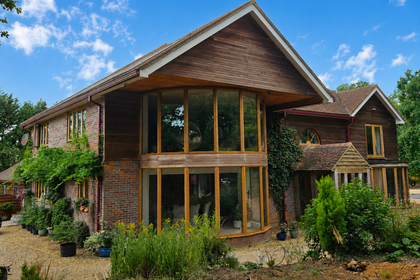
- Price
- Guide Price£1,650,000
- Size
- 8 acres
Greatwood House, Great Blakenham, Suffolk, IP6, Great Blakenham, Suffolk IP6 England
Added on 08/08/2026House with Land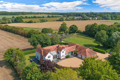
- Price
- Guide Price£1,500,000
- Size
- 6.7 acres
Added on 11/09/2026House with Land