St Ive, Liskeard - Cornwall
- Land size
- 53 acres
- Bedrooms
- 5
- Bathrooms
- 4
Key Features
- 5 bedroom Barn conversion
- 4 bedroom house
- 53 Acre Residential Farm
- Arable, Grass and Woodland
- Livestock / General Purpose Buildings
- Amenity woodland
- Easily Accessible
- Rural Location
Description
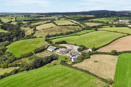
Secluded livestock and residential farm in a sheltered valley setting. Impressive 5 bedroom barn conversion and 4 bedroom farmhouse. Livestock and general purpose buildings. Arable/grassland and amenity woodland.
Upham Farm - The Farm is quietly situated a short distance from the rural village of St Ive. Callington lies 3 miles to the east and Liskeard 6 miles to the west, both offering day-to-day facilities including independent shops, supermarkets, healthcare, education, and leisure amenities. Launceston (A30) is 14 miles to the north, and Plymouth (A38) is 17 miles to the south-east.
The Farm is a well-located 53-acre livestock, arable, and residential holding. It features a spacious bespoke five-bedroom barn conversion offering comfortable and flexible family living, alongside a well-presented four-bedroom farmhouse. A useful range of livestock and general-purpose buildings, workshop space, attractive arable and grassland, and areas of amenity woodland complete the property.
Damson Barn - This bespoke five-bedroom barn conversion is finished to a high standard and benefits from oil-fired central heating, underfloor heating to the ground floor, radiators to the first floor, and double-glazed windows and doors. The accommodation briefly comprises: -
On The Ground Floor - Entrance Hall: Chestnut laminate flooring, steps to the lower ground floor, stairs to the first floor. Utility / Boot Room: Tiled floor, base units with beech-block effect worksurface, stainless steel sink and drainer, plumbing for washing machine and tumble dryer. Cloakroom: Tiled floor, wash basin and WC. Study: Chestnut laminate flooring, window to the side. Kitchen / Dining Room: Fitted wall and base units with quartz worksurfaces, Smeg electric range cooker with induction hob and extractor, built-in dishwasher, central island with storage and quartz worksurface, bi-fold powder-coated double-glazed doors opening to the rear garden. Pantry: Fitted shelving. Sitting Room: Dual aspect with views over the land and surrounding countryside, chestnut laminate flooring, woodburning stove on polished black granite hearth. Lower Ground Floor - Two double bedrooms. Family Bathroom: Wash basin, WC, and P-shaped bath with shower over. On The First Floor Two double bedrooms. Bathroom: Wash basin, WC, and P-shaped bath with shower over. Master Suite: Large dual-aspect bedroom with door to a balcony enjoying far-reaching views. Dressing Room: Fitted wardrobes, hanging space, drawers. En Suite: Vanity unit with twin sinks, double-ended bath, shower enclosure, heated towel rails, and separate cloakroom with WC and corner vanity unit.
Upham House - The well-presented and spacious farmhouse retains many character features including natural stone inglenook fireplaces and beamed ceilings. It benefits from uPVC double-glazed windows and doors and LPG-fired central heating. The accommodation briefly comprises: On The Ground Floor; Sitting Room: Inglenook fireplace with woodburning stove. Kitchen / Breakfast Room: Wood-effect tiled floor, fitted wall and base units with beech-block effect roll-top worksurfaces, 1½ bowl stainless steel sink, space for washing machine, Kenwood electric range cooker with extractor, inglenook fireplace with bread oven, beamed ceiling. Utility / Boot Room: Butler’s sink, plumbing for washing machine, door to rear. Cupboard: Housing hot water cylinder, boiler, and storage. On The First Floor; Landing: Staircase to second floor. Family Bathroom: Double-ended bath, shower enclosure, vanity unit with wash hand basin, WC, heated towel rail. Bedroom: Window to rear. Master Suite: Generous double bedroom with dressing room
ursery. En Suite: Shower, WC, vanity unit with wash hand basin. On The Second Floor; Double bedroom with window overlooking the garden and countryside. En Suite: Wash basin, WC, heated towel rail, shower enclosure with full body jets.
Outside - To the front of the farmhouse is a parking area. A path leads around to the rear garden, which features a lawned terrace, flowerbed borders, fruit trees, and is enclosed by wooden fencing and tree-lined Cornish bank hedging.
The Land - The farm extends to approximately 53 acres in a ring fence. The attractive and varied land is divided into 12 easily managed enclosures, predominantly grassland with small areas of arable and amenity woodland.
Workshop - 15.24m x 13.72m (49'11" x 45'0" ) -
General Purpose / Livestock Building: - 7.35m x 6.20m (24'1" x 20'4") -
Adjoining Workshop - 11.50m x 7.45m (37'8" x 24'5" ) -
Adjoining General Purpose Store - 22.55m x 3.62m (73'11" x 11'10" ) -
Opening To General Purpose Store / Workshop - 12m x 14m (39'4" x 45'11" ) -
Adjoining Lean To - 4.78m x 3.98m (15'8" x 13'0" ) -
Adjoining Workshop / Store - 11.85m x 6.90m (38'10" x 22'7" ) -
Livestock Building - 14.75m x 18.15m (48'4" x 59'6" ) - Of steel frame portal construction.
Adjoining Fodder / Livestock Building - 14.75m x 6m (48'4" x 19'8" ) -
General Purpose / Livestock Building - 18.25m x 7m (59'10" x 22'11" ) -
Nissen Hut Storage Building - 8.45m x 3.01m (27'8" x 9'10" ) -
Services & Information - Water – mains
Drainage – Barn – septic tank; House – treatment plant
Electricity – Mains
Heating – Damson Barn - Oil fired central heating and woodburning stove
Upham House – LPG fired central heating and woodburning stove
Broadband – 4G receiver
Mobile Availability - checker.ofcom.org.uk
Council Tax Currently Band - C / TBA
EPC – Upham Farmhouse E42 Damson Barn C75
Renewable Energy – Photovoltaic solar panels on the roof of Damson
Construction – Upham House Stone / Damson Barn Stone and Block
Local Authority - Cornwall Council
Country Hall, Treyew Road, Truro, Cornwall, TR1 3AY.
Tenure - The property is offered for sale freehold with vacant possession on completion.
Viewing Arrangements - Strictly by appointment with D. R. Kivell Country Property . All viewings are to be accompanied without exception. Walking the land unaccompanied is strictly forbidden as livestock are present.
Map Location
Property details
- Tenure
- Freehold
- Council Tax Band
- C
- Date Posted
- 2026-08-21
Market Value Analysis
Compared with 41 Farms & Smallholdings listings in South West England (50+ acres).
Energy Performance Certificate
Energy Efficiency Rating
Based on UK Energy Performance Certificate standards (EU Directive 2002/91/EC)
Utilities & Restrictions
Utilities
- Electricity
- Mains
- Water
- Mains
- Heating
- Gas Heating, Oil Heating, Wood Burner
- Broadband
- Ask Agent
- Sewerage
- Septic Tank / Private
Rights & Restrictions
- Public Rights of Way
- Ask Agent
- Private Rights of Way
- Ask Agent
- Listed Property
- Ask Agent
- Restrictions
- Ask Agent
Property Features
- Accessibility
- Ask Agent
- Parking
- Driveway
- Garden
- Garden
Connectivity
Broadband
Fastest speed available at this postcode
6 Mbps
Under 10 Mbps here
Suitable for
- Basic browsing & email
Fixed wireless access may also be an option here.
Mobile signal
Outdoor predictions; indoor signal depends on building materials.
Ofcom Connected Nations postcode-level predictions. Speeds and signal are modelled, not measured, and vary between addresses and providers.
Nearest Schools
Primary
- Quethiock CofE School1.8 milesOfsted: Good
- Ages
- 2 to 11
- Pupils
- 62
- Type
- Academy converter
- Faith
- Church of England
- Callington Primary School2.3 milesNo Ofsted rating
- Ages
- 3 to 11
- Pupils
- 354
- Type
- Academy converter
- Pensilva Primary School3 milesOfsted report card · Feb 2026
- Ages
- 4 to 11
- Pupils
- 101
- Type
- Community school
- Menheniot Primary School3.7 milesOfsted: Good
- Ages
- 4 to 11
- Pupils
- 138
- Type
- Foundation school
- St Mellion Church of England Primary School3.8 milesNo Ofsted rating
- Ages
- 3 to 11
- Pupils
- 33
- Type
- Academy converter
- Faith
- Church of England
Secondary
- Callington Community College2.6 milesOfsted: Good
- Ages
- 11 to 18
- Pupils
- 887
- Type
- Academy converter
- Liskeard School and Community College5.1 milesNo Ofsted rating
- Ages
- 11 to 18
- Pupils
- 1,115
- Type
- Academy converter
- Saltash Community School8 milesOfsted: Good *
- Ages
- 11 to 18
- Pupils
- 1,139
- Type
- Academy converter
- Looe Community Academy9 milesOfsted report card · Feb 2026
- Ages
- 11 to 16
- Pupils
- 513
- Type
- Academy converter
- Marine Academy Plymouth9.4 milesOfsted: Good
- Ages
- 11 to 18
- Pupils
- 989
- Type
- Academy sponsor led
* Latest graded judgement covers quality of education only; no overall grade was issued under the 2024-25 inspection framework.
Distances are straight-line from the advertised location. Source: the national school registers (DfE, Welsh Government, Scottish Government) and Ofsted.
Amenities
Supermarket
GP surgery
Pharmacy
Hospital
Straight-line distances from the advertised location. Sources: NHS records, Geolytix supermarket locations, OS Open Greenspace and the national trails registers.
Getting Around
Nearest station
Nearest bus stop
Typical drive times
Straight-line distances from the advertised location; drive times are typical free-flow times over OpenStreetMap road data, so allow more at peak. Public transport locations from DfT NaPTAN.
Flood Risk
From Environment Agency flood map open data, checked around the advertised map pin and allowing for the listed acreage where known. This summary comes from LandSale, the advertising platform, not from the listing agent, and is not part of the agent's particulars. Risk can vary across a single holding, so verify anything critical through your own searches before committing.
Rivers and the sea
Surface water
Mapped within the area searched, not at the advertised map pin itself.
The detail behind these bandings, including exact zones and annual chances, any recorded past flooding, plus planning, heritage, nature and ground checks, is in the .
Important notice: Information, maps and tags on this page are supplied by the advertising agent or generated automatically. LandSale has not verified them. Relying on these details is at your own risk, always carry out independent checks before committing to a purchase.
LandSale full disclaimer
Marketing information only - not formal particulars. The details on this website are provided for general guidance and do not constitute an offer or contract. Neither LandSale nor the advertising estate/land agent accepts responsibility for any inaccuracy.
1. Source of information
- Agent-supplied content: Core description, asking price, tenure, measurements, photographs and planning history are uploaded by the appointed agent, who remains solely responsible for their accuracy.
- Automated tags & categorisation: Property type, land-use class, acreage bands and similar labels may be applied by machine-learning models. They are intended as a helpful guide only and may not reflect the property's legal status or permitted use.
- Third-party & enriched data layers: Maps, boundary outlines, planning designations, soil reports, broadband coverage and other environmental or location-based insights are licensed from external suppliers. Such data are supplied “as is", may be incomplete or out of date and are subject to change without notice.
2. Verification required
Prospective purchasers must verify critical matters, including but not limited to planning permission, title boundaries, public rights of way, environmental constraints, acreage, services, access and VAT status, through their own inspections, specialist surveys, legal advisers and the selling agent before relying on the information or entering into any contract.
3. No warranty or liability
LandSale gives no warranty, express or implied, as to the accuracy, completeness or fitness for any particular purpose of the information displayed. LandSale shall not be liable for any loss, damage, cost or expense arising directly or indirectly from any use of or reliance on such information, save where liability may not be excluded by law.
4. Updates & feedback
If you believe any detail on this listing is inaccurate, please let us know. We will investigate and, where appropriate, update the listing or notify the agent.
© LandSale | Version 1.2 - January 2026
Listing agent
D. R. Kivell Country Property, Covering South West
Covering South West
Call agent
01822810810Contact D. R. Kivell Country Property, Covering South West
Covering South West
Call agent
01822810810Similar properties for sale
- Price
- £1,595,000
- Size
- 53 acres
St Ive, Liskeard - Cornwall, St. Ive and Pensilva, Cornwall PL14 England
Added on 25/07/2026Farm
- Price
- Guide Price£1,400,000
- Size
- 141.4 acres
Added on 04/06/2026Farm
- Price
- Guide Price£1,550,000
- Size
- 40 acres
Added on 02/06/2026Country Estate
- Price
- Offers in Excess of£1,500,000
- Size
- 30 acres
Launceston, Cornwall, PL15, Launceston, Cornwall PL15 England
Added on 06/05/2026Equestrian property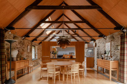
- Price
- £1,950,000
- Size
- 37 acres
Added on 09/07/2026Barn Conversion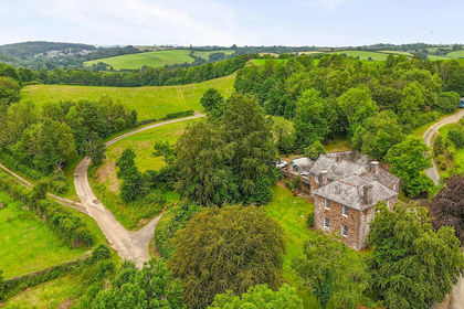
- Price
- Guide Price£1,500,000
- Size
- 58.74 acres
Added on 23/07/2026House with Land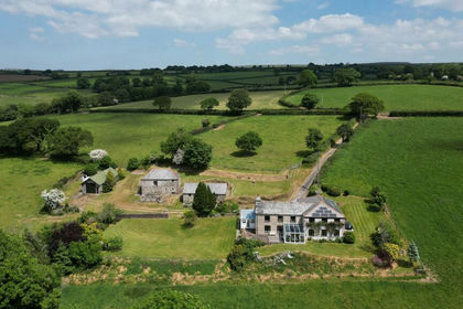
- Price
- Guide Price£1,350,000
- Size
- 77.05 acres
Added on 13/05/2026Farmhouse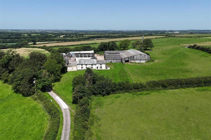
- Price
- £1,200,000
- Size
- 32 acres
Pancrasweek, Holsworthy - Devon, Pancrasweek, Devon EX22 England
Added on 02/07/2026House with Land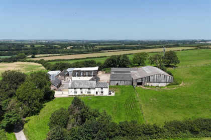
- Price
- £1,200,000
- Size
- 32 acres
Pancrasweek, Holsworthy - Devon, Pancrasweek, Devon EX22 England
Added on 29/06/2026House with Land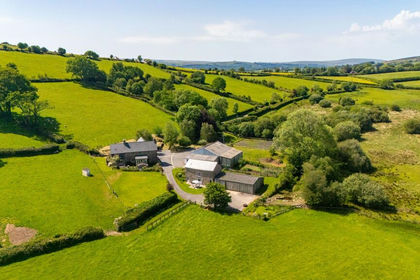
- Price
- Guide Price£1,695,000
- Size
- 32.35 acres
North Bovey, Newton Abbot, TQ13, North Bovey, Devon TQ13 England
Added on 28/04/2026Farm