Pilgrims Way, Charing
- Land size
- 1.85 acres
- Bedrooms
- 4
- Bathrooms
- 3
Key Features
- Striking high-spec 4 bedroom single-storey home with an individual H-shaped design & approximately 2,166 sq. ft. of accommodation
- Set within approximately 1.85 acres in a peaceful semi-rural position with far-reaching countryside views towards the North Downs
- Impressive 44' open-plan kitchen/living/dining room with vaulted ceilings, expansive glazing & direct access onto the terrace
- Bespoke contemporary kitchen with a hob, 2 ovens, FF, wine fridge, coffee machine, MW, DW & Quooker tap
- Principal bedroom suite with dressing room & en-suite, complemented by 3 further bedrooms & 2 additional bath/shower rooms
- Carefully planned single-storey layout with a separate bedroom wing, study, utility room, pantry & dedicated plant room
- Built with sustainability at its core, including solar panels & battery storage, infrared heating, MVHR & rainwater harvesting
- Expansive decked terrace with outdoor kitchen, bar, barbecue & pizza oven overlooking the surrounding countryside
- Integral garage, separate storage outbuilding, Tesla EV charger & private driveway parking for several vehicles
- EPC rating B, all-level accommodation & no onward chain. Within easy reach of Charing village & Ashford
Description
Property Description: CHAIN FREE. Set within approximately 1.85 acres on the edge of Charing, 1 Palace View is an individual contemporary home where architecture, landscape and energy-conscious design have been considered together from the outset.
Built as a high-specification single-storey residence, the house has a distinctive H-shaped footprint that separates the principal living areas from the bedroom wing while retaining a natural connection throughout. Clean architectural lines, dark finishes, vaulted ceilings and large areas of glazing give the house a strong modern character, with the surrounding countryside forming part of the interior from almost every angle.
At the heart of the house is the open-plan kitchen, living and dining room, extending to approximately 44 feet in length. This is a dramatic yet comfortable space, with a vaulted ceiling and full-height glazing drawing the eye towards the landscape beyond. The kitchen has been designed around a large central island, combining extensive storage and preparation space with an informal place to sit. The fitted appliances include a hob, two ovens, a fridge, a freezer, a wine fridge, a dishwasher, a coffee machine, a microwave, a built in ice machine and Quooker tap, while a separate pantry and utility room keep the practical side of everyday life away from the main living area.
The living area sits beneath the same vaulted roofline, with a contemporary fireplace creating a focal point and wide glazed doors opening directly onto the terrace. The combination of large windows and carefully positioned openings gives uninterrupted views across the surrounding fields while bringing a remarkable amount of natural light into the room. A separate study creates a dedicated space for working from home and also leads to a relaxing outdoor space, while a cloakroom, utility room, pantry and plant room complete the central and living section of the property.
The bedroom wing has been deliberately positioned away from the main entertaining space. The principal bedroom is a particularly private retreat, with a generous dressing room, en-suite shower room and doors opening directly onto the grounds. There are three further bedrooms, including another bedroom with its own en-suite shower room, together with a family bathroom. Built-in wardrobes provide useful storage, and the entire property is arranged over one level.
Sustainability has played a central role in the design. The specification includes solar panels with battery storage, infrared heating, Mechanical Ventilation with Heat Recovery (MVHR), a smart hot water system and rainwater harvesting. All rooms have automatic Somfy electric fitted blinds that can be programmed to open and close, alongside mood lighting system and switches, all of which are controlled via an app.
Outside: A broad decked terrace runs along the house, creating a direct continuation of the main living space outside. Designed for entertaining, it features an outdoor kitchen, bar, barbecue and pizza oven, providing the perfect setting for relaxed evenings with family and friends whilst taking full advantage of the far-reaching rural views. The landscaped gardens blend seamlessly into the surrounding grounds, with approximately 1.85 acres providing both privacy and space to enjoy the peaceful setting.
The integral garage is joined by a separate storage outbuilding, while the driveway has parking for several vehicles and a Tesla EV charger. There may also be scope within the grounds for an additional outbuilding or annexe, subject to the necessary planning permission.
Despite the sense of openness and privacy, the house remains conveniently placed for Charing village and the surrounding road and rail network. The vendors highlight straightforward access towards the A20, M20 and M2, with Ashford International station within approximately a 15-minute drive.
Location: Charing is a small but lively village in the Ashford District of Kent, situated at the foot of the North Downs. The village is sited on the Pilgrims' Way from London to Canterbury and is still surrounded by farmland, but the good transport links have also led to the area becoming a popular commuter village. Lots of stunning, scenic walks can be had within the village and surrounding countryside. Charing station has connecting services to London St Pancras via Ashford International in an hour or London Victoria station in approximately 1 hour and 20 minutes. The village has a strong community life and the locals organise regular fairs, community and charity events. On the High Street and surrounding streets you will find a wide variety of independent shops, restaurants and services. 'The Bookmaker's Arms' micro brewery is a welcome addition to The High Street. There is a Sports Pavilion which hosts a fantastic social club, home to the Village Cricket, Football and Tennis Clubs. There is also a thriving Boules club and a new Scouts Hut for the Scouts and Cubs. The library in the market place is popular with young and old and holds weekly 'story sessions' for toddlers. The 'Charing Christmas Lights' are an event to behold which attracts visitors throughout December to come and marvel at the beautifully lit high street - supported by fundraisers in the community throughout the year. The summer fayre on Cleward's Meadow is also a highlight on the Charing calendar. The market town of Ashford is just a short drive away where there are excellent shopping opportunities with the McArthur Glen designer outlet. Supermarkets include a Waitrose and a large Sainsbury's.
Directions: SatNav = TN27 0NA / What3Words = campers.blush.remaking
Council Tax: Band F (correct at time of marketing). To check council tax for this property, please refer to the local authority website.
Local Authority: Ashford Borough Council . Kent County Council .
Services: Mains water and electricity, solar panels and private drainage. For broadband and mobile coverage, we advise you check your providers website or refer to an online checker.
Tenure: This property is freehold and is sold with vacant possession upon completion. Landlord electricity supply jointly shared between 3 properties approx. £60 per annum.
Disclaimer: Sandersons and their clients state that these details are for general guidance only and accuracy cannot be guaranteed. They do not form any part of any contract. All measurements are approximate, and floor plans are for general indication only and are not measured accurate drawings. No guarantees are given with any mentioned planning permission or fitness for purpose. No appliances, equipment, fixture or fitting has been tested by us and items shown in photographs are not necessarily included. Buyers must satisfy themselves on all matters by inspection or through the conveyancing process.
Identity verification: Please note, Sandersons UK are obligated by law to undertake Anti Money Laundering (AML) Regulations checks on any purchaser who has an offer accepted on a property. We are required to use a specialist third party service to verify your identity. The cost of these checks is £60 inc.VAT per property and accepted offer. This is payable at the point an offer is accepted and our purchaser information form is completed, prior to issuing Memorandum of Sales to both parties respective conveyancing solicitors. This is a legal requirement and the charge is non-refundable.
Disclaimer: Please note the image with the boundary line is for indicative purposes only and will be need to be confirmed via Land Registry during the conveyancing process.
Additional Property Notes: The property is of traditional construction with elements of Siberian larch cladding and has had no adaptations for accessibility. There is off road parking for several cars in front of the property and a garage. Right of Access over neighbours property to paddock via track to side of property.
Register for new listings before the portal launch
Map Location
Property details
- Tenure
- Freehold
- Council Tax Band
- F
- Date Posted
- 2026-08-16
Market Value Analysis
Compared with 1,736 Homes with Land listings in South East England (1+ acres).
Energy Performance Certificate
Energy Efficiency Rating
Based on UK Energy Performance Certificate standards (EU Directive 2002/91/EC)
Running costs are one side. Planning activity, flood history and ground risks for this location are in the full report.
Utilities & Restrictions
Utilities
- Electricity
- Mains
- Water
- Mains
- Heating
- Electric Heating, Solar Heating
- Broadband
- Ask Agent
- Sewerage
- Septic Tank / Private
Rights & Restrictions
- Public Rights of Way
- Ask Agent
- Private Rights of Way
- Ask Agent
- Listed Property
- Ask Agent
- Restrictions
- Ask Agent
Listed status, conservation areas and planning constraints for this location are in the full report.
Property Features
- Accessibility
- Ask Agent
- Parking
- Parking Available
- Garden
- Rear Garden
Beyond the particulars: planning activity, flood history, heritage and ground risks, checked for this exact spot.
Connectivity
Broadband
Fastest speed available at this postcode
80 Mbps
Superfast
Suitable for
- HD streaming
- Video calls
- Web & social
Fixed wireless access may also be an option here.
Mobile signal
Predicted 4G and 5G signal; indoor signal depends on building materials.
Ofcom Connected Nations postcode-level predictions. Speeds and signal are modelled, not measured, and vary between addresses and providers.
Signal is the easy part. Planning activity, flood history and protected designations here are in the full report.
Nearest Schools
Primary
- Charing Church of England Primary School804 metresOfsted report card · Feb 2026
- Ages
- 2 to 11
- Pupils
- 199
- Type
- Academy converter
- Faith
- Church of England
- Challock Primary School3.1 milesOfsted: Outstanding
- Ages
- 4 to 11
- Pupils
- 212
- Type
- Foundation school
- Pluckley Church of England Primary School3.5 milesNo Ofsted rating
- Ages
- 3 to 11
- Pupils
- 82
- Type
- Academy converter
- Faith
- Church of England
- Egerton Church of England Primary School3.7 milesOfsted: Good
- Ages
- 4 to 11
- Pupils
- 197
- Type
- Voluntary controlled school
- Faith
- Church of England
- Eastling Primary School4.1 milesOfsted report card · Jan 2026
- Ages
- 4 to 11
- Pupils
- 104
- Type
- Community school
Secondary
- The Lenham School4.4 milesOfsted: Good
- Ages
- 11 to 18
- Pupils
- 820
- Type
- Academy sponsor led
- Towers School and Sixth Form Centre4.4 milesOfsted: Good *
- Ages
- 11 to 19
- Pupils
- 1,538
- Type
- Academy converter
- Highworth Grammar School4.9 milesOfsted: Outstanding *
- Ages
- 11 to 18
- Pupils
- 1,553
- Type
- Academy converter
- Gender
- Girls
- Chilmington Green School5.8 milesOfsted report card · May 2026
- Ages
- 11 to 19
- Pupils
- 449
- Type
- Free schools
- The Norton Knatchbull School6 milesOfsted: Good
- Ages
- 11 to 18
- Pupils
- 1,348
- Type
- Academy converter
- Gender
- Boys
* Latest graded judgement covers quality of education only; no overall grade was issued under the 2024-25 inspection framework.
Distances are straight-line from the advertised location. Source: the national school registers (DfE, Welsh Government, Scottish Government) and Ofsted.
Schools are just the start: sold prices nearby, planning activity and any flood history are in the full report.
Amenities
Supermarket
GP surgery
Pharmacy
Hospital
Green space
Walking trail
Straight-line distances from the advertised location. Sources: NHS records, Geolytix supermarket locations, OS Open Greenspace and the national trails registers.
The area stacks up? Now check the location itself: planning nearby, protected designations and past flooding.
Getting Around
Nearest station
Nearest bus stop
Typical drive times
Straight-line distances from the advertised location; drive times are typical free-flow times over OpenStreetMap road data, so allow more at peak. Public transport locations from DfT NaPTAN.
Easy to reach matters. So do planning activity, flood history and ground risks: all in the full report.
Flood Risk
Environment Agency open data, checked around the advertised map pin for the listed acreage. Long-term risk counts flood defences; the planning map's flood zones do not. Provided by LandSale, not the listing agent, and not part of the agent's particulars. Risk varies across a holding, so verify before committing.
Rivers and the sea
Planning map: Flood Zone 1.
Surface water
These bandings are the summary. Where this location sits on the flood maps, plus planning activity, heritage and ground risks, is in the full report.
Important notice: Information, maps and tags on this page are drawn from the advertising agent's marketing materials or generated automatically. LandSale has not verified them. Relying on these details is at your own risk, always carry out independent checks before committing to a purchase.
LandSale full disclaimer
Marketing information only - not formal particulars. The details on this website are provided for general guidance and do not constitute an offer or contract. Neither LandSale nor the advertising estate/land agent accepts responsibility for any inaccuracy.
1. Source of information
- Listing content: Core description, asking price, tenure, measurements, photographs and planning history originate from the marketing materials of the advertising estate or land agent. LandSale does not author this content and cannot guarantee its accuracy.
- Automated tags & categorisation: Property type, land-use class, acreage bands and similar labels may be applied by machine-learning models. They are intended as a helpful guide only and may not reflect the property's legal status or permitted use.
- Third-party & enriched data layers: Maps, boundary outlines, planning designations, soil reports, broadband coverage and other environmental or location-based insights are licensed from external suppliers. Such data are supplied “as is", may be incomplete or out of date and are subject to change without notice.
2. Verification required
Prospective purchasers must verify critical matters, including but not limited to planning permission, title boundaries, public rights of way, environmental constraints, acreage, services, access and VAT status, through their own inspections, specialist surveys, legal advisers and the selling agent before relying on the information or entering into any contract.
3. No warranty or liability
LandSale gives no warranty, express or implied, as to the accuracy, completeness or fitness for any particular purpose of the information displayed. LandSale shall not be liable for any loss, damage, cost or expense arising directly or indirectly from any use of or reliance on such information, save where liability may not be excluded by law.
4. Updates & feedback
If you believe any detail on this listing is inaccurate, please let us know. We will investigate and, where appropriate, update the listing or notify the agent.
© LandSale | Version 1.3 - August 2026
Listing agent
Sandersons, Covering Ashford
Covering Ashford
Similar properties for sale
- Price
- £1,200,000
- Size
- 1.5 acres
Added on 24/06/2026House with Land
- Price
- Guide Price£1,150,000
- Size
- 7 acres
Added on 25/05/2026Equestrian property
- Price
- Guide Price£1,195,000
- Size
- 5.03 acres
Westwell Leacon, Charing, Ashford, Kent, TN27, Charing, Kent TN27 England
Added on 16/09/2026House with Land
- Price
- Offers in Excess of£1,500,000
- Size
- 0.65 acres
Added on 28/01/2026Barn Conversion
- Price
- £1,400,000
Added on 17/07/2026Development Land
- Price
- Guide Price£995,000
- Size
- 2.5 acres
Iden Lane, Egerton, Ashford, Kent, TN27, Egerton, Kent TN27 England
Added on 09/08/2026Country Home
- Price
- £1,075,000
- Size
- 5.5 acres
Church Lane, Hothfield, Ashford, Kent, TN26, Hothfield, Kent TN26 England
Added on 01/07/2026House with Land
- Price
- £1,200,000
- Size
- 2 acres
Park Lane Cottage & Annexe, Throwley Road, Throwley, Throwley, Kent ME13 England
Added on 13/03/2026House with Land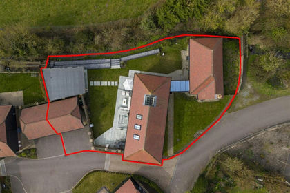 Added on 27/03/2026Barn Conversion
- Price
- £1,500,000
- Size
- 10.2 acres
Added on 03/07/2026House with Land