Llanarmon Road, Bwchgwyn LL11
- Land size
- 6 acres
- Bedrooms
- 3
- Bathrooms
- 1
Key Features
- PRIVATE 6 ACRE COUNTRY HOUSE
- 3 BEDROOM DETACHED STONE HOUSE WITH RURAL VIEWS
- DETACHED 1493 SQFT 3 BAY GARAGE UNIT, POTENTIAL EQUESTRIAN USE
- PLANNING PERMISSION FOR A 4 BEDROOM DETACHED DWELLING
- PLANNING FOR DETACHED GARAGE, EV CHARGING POINTS
- ENTRANCE PORCH, SPACIOUS LOUNGE WITH LOG BURNER
- FITTED KITCHEN, DINING ROOM
- GARDEN ROOM WITH BI FOLD DOORS
- AMPLE PARKING FOR DOMESTIC AND COMMERCIAL VEHICLES
- EPC RATING - D (58)
Description
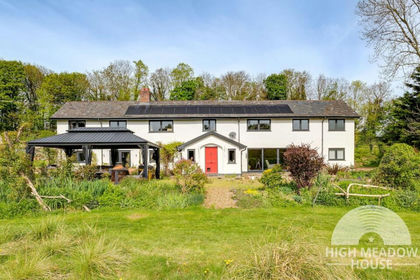
Set back from the road along a tree lined gated drive is this private and attractive stone built 3 bedroom detached country house having been extended by the current owners, set within approximately 6 acres to include over 5 acres of grazing land, with excellent potential for equestrian use, garden, 3 bay detached garage, planning for a 4 bedroom detached single storey dwelling ( with agricultural restriction ) and planning for an additional detached garage. Situated in a rural location yet close to excellent road links to Wrexham, Chester and Ruthin and the nearby amenities in Bwlchgwyn and Coedpoeth. The accommodation briefly comprises an enclosed entrance porch, dining room with staircase to 1st floor, light and bright garden room with bi fold doors opening to the patio, fitted kitchen with utility/rear porch off and a spacious triple aspect lounge with beams to ceiling and the warmth of a log burner. The 1st floor landing connects the 3 double bedrooms, all with countryside views, and a shower room. The land and buildings provide a fantastic opportunity, (subject to any planning consents) to generate an income or owners use especially for a commercial business. The grazing land can be divided into 4 sections and there is ample parking for multiple vehicles including horse boxes/trailers. Mature trees border the land and provide an excellent degree of privacy. Viewing highly recommended. EPC RATING - D (58)
Location - Enjoying a lovely rural position on the fringe of the village of Bwlchgwyn yet having the benefit of excellent road links to Wrexham, Chester, Mold and Ruthin. The village includes a public house/restaurant and primary school whilst the nearby village of Coedpoeth offers a wider variety of amenities, doctors, dentists and bus service. The area is popular amongst walkers' and cyclists due to its bikers trails and unspoilt countryside.
Directions - Proceed out of Wrexham along the A525 in the direction of Ruthin. Proceed through the village of Coedpoeth and bear left signposted Gwynfryn. Continue for approximately 1 mile to the traffic lights, straight across onto Llanarmon Road and the entrance to Lakefield House will be observed on the left just after the bend.
Entrance - Part glazed composite entrance door opens to the enclosed porch with quarry tiled floor, Upvc double glazed window and part glazed door to dining room.
Dining Room - 3.7 x 3.2 (12'1" x 10'5") - A family sized dining room with Upvc double glazed window overlooking the front garden with deep cill, staircase to 1st floor landing, radiator and Upvc French doors opening to the garden room.
Garden Room - 4.3 x 3.8 (14'1" x 12'5") - A superb addition to the cottage featuring double glazed bi fold doors opening out to the patio area, raised ceiling with Velux roof light window, radiator, wood effect flooring and Upvc double glazed window.
Kitchen Breakfast Room - 3.9 x 2.8 (12'9" x 9'2") - Appointed with a shaker style range of base and wall cupboards complimented by wood effect work surface areas incorporating a stainless steel single drainer sink unit with mixer tap and Upvc double glazed window above, 4 ring electric hob, Bosch double oven/grill, Worcester oil fired central heating boiler, integrated fridge, part tiled walls, Upvc double glazed window to side, radiator and arch through to the lounge.
Lounge - 6.2 x 3.8 (20'4" x 12'5") - A spacious reception room enjoying a triple aspect through 3 Upvc double glazed windows, stone fireplace with inset 2 door log burner, 2 wall light points, beams to ceiling and 2 radiators.
Utility/Rear Porch - Accessed off the kitchen having plumbing for washing machine, 2 Upvc double glazed windows, quarry tiled floor, space for fridge freezer and Upvc part glazed external door.
1st Floor - Approached via the staircase from the dining room with alarm control panel, 2 door airing cupboard with hot water cylinder and slatted shelving.
Bedroom 1 - 3.9 x 3.3 (12'9" x 10'9") - Upvc double glazed window to front with tiled cill, radiator, wall light points, mirror fronted wardrobes and ceiling hatch to roof space.
Bedroom 2 - 3.3 x 2.8 (10'9" x 9'2") - Upvc double glazed window to front, radiator and useful built in store cupboard.
Bedroom 3 - 4.1 max x 2.8 (13'5" max x 9'2") - Upvc double glazed window to rear and radiator.
Shower Room - 2.7 x 2.5 (8'10" x 8'2") - Appointed with a white suite of walk in shower with electric shower unit, splash screen and wipe clean wall panels, w.c. and wash basin within vanity unit providing excellent storage space, chrome heated towel rail, Upvc double glazed window, illuminated mirror, radiator and part tiled walls.
Outside - A gated and tree lined private driveway leads alongside 3 enclosed parcels of grazing land to include planning for a detached 4 bedroom single storey dwelling with agricultural restriction. The drive continues to the cottage, with ev charging point, and opens out to provide plenty of parking for vehicles to include commercial, equestrian and agricultural, and then continues to the detached block and steel framed 3 bay garage measuring over 125 sqm to include 2 roller shutter doors, an open fronted bay, rear lean to and store room with w.c. and wash basin. The garage block benefits from its own electric supply and ev charging point. The yard area includes planning for a further detached garage and gives access to a further parcel of grazing land.
Garden - To the front of the cottage is a lovely private lawned garden, ideal for outdoor activities especially for children, together with a path that leads to the delightful Indian stone paved patio that adjoins the Garden Room and offers a relaxing, sociable entertaining space for adults.
Map Location
Property details
- Tenure
- Freehold
- Council Tax Band
- Ask Agent
- Date Posted
- 2026-08-08
Price history
| Date | Change | Price |
|---|---|---|
| 10 Oct 2026 | Reduced 3.3% (−£25,000) | £725,000 |
| 8 Aug 2026 | Listed | £750,000 |
Market Value Analysis
Compared with 375 Homes with Land listings in Wales (5+ acres).
Energy Performance Certificate
Energy Efficiency Rating
Based on UK Energy Performance Certificate standards (EU Directive 2002/91/EC)
Running costs are one side. Planning activity, flood history and ground risks for this location are in the full report.
Utilities & Restrictions
Utilities
- Electricity
- Mains
- Water
- Mains
- Heating
- Oil Heating
- Broadband
- Ask Agent
- Sewerage
- Septic Tank / Private
Rights & Restrictions
- Public Rights of Way
- Ask Agent
- Private Rights of Way
- Ask Agent
- Listed Property
- Ask Agent
- Restrictions
- Ask Agent
Listed status, conservation areas and planning constraints for this location are in the full report.
Property Features
- Accessibility
- Ask Agent
- Parking
- Garage En Bloc
- Garden
- Garden
Beyond the particulars: planning activity, flood history, heritage and ground risks, checked for this exact spot.
Connectivity
Broadband
Fastest speed available at this postcode
1.8 Gbps
Gigabit full fibre · available to 88% of premises
Suitable for
- 4K streaming on every screen
- Full-time home working
- Online gaming & big downloads
Mobile signal
Predicted 4G and 5G signal; indoor signal depends on building materials.
Ofcom Connected Nations postcode-level predictions. Speeds and signal are modelled, not measured, and vary between addresses and providers.
Signal is the easy part. Planning activity, flood history and protected designations here are in the full report.
Nearest Schools
Primary
- Bwlchgwyn School1.2 miles
- Pupils
- 106
- Type
- Nursery, Infants & Juniors
- Language
- English medium school / provision
- Minera1.8 miles
- Pupils
- 91
- Type
- Nursery, Infants & Juniors
- Language
- English medium school / provision
- Ysgol Bryn Tabor2.7 miles
- Pupils
- 200
- Type
- Nursery, Infants & Juniors
- Language
- Welsh medium school / provision (including transitional)
- Penygelli C P School2.8 miles
- Pupils
- 255
- Type
- Nursery, Infants & Juniors
- Language
- English medium school / provision
- Ysgol Terrig2.9 miles
- Pupils
- 97
- Type
- Nursery, Infants & Juniors
- Language
- Welsh medium school / provision (including transitional)
Secondary
- Ysgol Bryn Alyn4.2 miles
- Pupils
- 701
- Type
- Secondary (ages 11-16)
- Language
- English medium school / provision
- Grango4.8 miles
- Pupils
- 580
- Type
- Secondary (ages 11-16)
- Language
- English medium school / provision
- Castell Alun High School4.9 miles
- Pupils
- 1,283
- Type
- Secondary (ages 11-19)
- Language
- English medium school / provision
- Ysgol Clywedog5.1 miles
- Pupils
- 801
- Type
- Secondary (ages 11-16)
- Language
- English medium school / provision
- St Joseph's Catholic and Anglican High5.8 miles
- Pupils
- 748
- Type
- Secondary (ages 11-16)
- Language
- English medium school / provision
Distances are straight-line from the advertised location. Source: the national school registers (DfE, Welsh Government, Scottish Government) and Ofsted.
Schools are just the start: sold prices nearby, planning activity and any flood history are in the full report.
Amenities
Supermarket
GP surgery
Pharmacy
Straight-line distances from the advertised location. Sources: NHS records, Geolytix supermarket locations, OS Open Greenspace and the national trails registers.
The area stacks up? Now check the location itself: planning nearby, protected designations and past flooding.
Getting Around
Nearest station
Nearest bus stop
Typical drive times
Straight-line distances from the advertised location; drive times are typical free-flow times over OpenStreetMap road data, so allow more at peak. Public transport locations from DfT NaPTAN.
Easy to reach matters. So do planning activity, flood history and ground risks: all in the full report.
Flood Risk
Natural Resources Wales open data, checked around the advertised map pin for the listed acreage. Long-term risk counts flood defences; the planning map's flood zones do not. Provided by LandSale, not the listing agent, and not part of the agent's particulars. Risk varies across a holding, so verify before committing.
Rivers and the sea
Planning map: Flood Zone 1.
Surface water
These bandings are the summary. Where this location sits on the flood maps, plus planning activity, heritage and ground risks, is in the full report.
Important notice: Information, maps and tags on this page are drawn from the advertising agent's marketing materials or generated automatically. LandSale has not verified them. Relying on these details is at your own risk, always carry out independent checks before committing to a purchase.
LandSale full disclaimer
Marketing information only - not formal particulars. The details on this website are provided for general guidance and do not constitute an offer or contract. Neither LandSale nor the advertising estate/land agent accepts responsibility for any inaccuracy.
1. Source of information
- Listing content: Core description, asking price, tenure, measurements, photographs and planning history originate from the marketing materials of the advertising estate or land agent. LandSale does not author this content and cannot guarantee its accuracy.
- Automated tags & categorisation: Property type, land-use class, acreage bands and similar labels may be applied by machine-learning models. They are intended as a helpful guide only and may not reflect the property's legal status or permitted use.
- Third-party & enriched data layers: Maps, boundary outlines, planning designations, soil reports, broadband coverage and other environmental or location-based insights are licensed from external suppliers. Such data are supplied “as is", may be incomplete or out of date and are subject to change without notice.
2. Verification required
Prospective purchasers must verify critical matters, including but not limited to planning permission, title boundaries, public rights of way, environmental constraints, acreage, services, access and VAT status, through their own inspections, specialist surveys, legal advisers and the selling agent before relying on the information or entering into any contract.
3. No warranty or liability
LandSale gives no warranty, express or implied, as to the accuracy, completeness or fitness for any particular purpose of the information displayed. LandSale shall not be liable for any loss, damage, cost or expense arising directly or indirectly from any use of or reliance on such information, save where liability may not be excluded by law.
4. Updates & feedback
If you believe any detail on this listing is inaccurate, please let us know. We will investigate and, where appropriate, update the listing or notify the agent.
© LandSale | Version 1.3 - August 2026
Listing agent
Wingetts, Wrexham
29 Holt Street, Wrexham, LL13 8DH
Similar properties for sale
- Price
- £850,000
- Size
- 8 acres
Cae-Pen-Ty Road, Cefn-Y-Bedd, LL12, Llanfynydd, Flintshire LL12 Wales
Added on 14/04/2026Equestrian property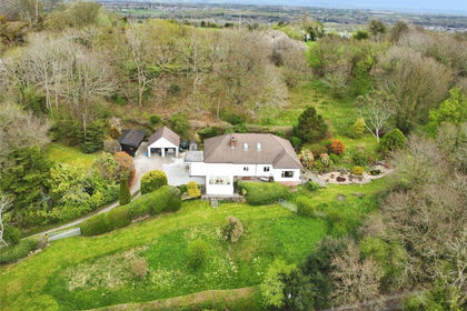
- Price
- £795,000
- Size
- 5 acres
Added on 18/04/2026House with Land
- Price
- Offers Over£775,000
- Size
- 3.5 acres
Hope Mountain, Caergwrle, Wrexham, Hope, Flintshire LL12 Wales
Added on 27/06/2026House with Land
- Price
- £850,000
- Size
- 144.65 acres
Tan Y Fron Lane, Llangollen, Llantysilio, Denbighshire LL20 Wales
Added on 20/08/2026House with Land
- Price
- £680,000
- Size
- 45 acres
Horseshoe Pass, Llangollen, Llantysilio, Denbighshire LL20 Wales
Added on 29/01/2026Smallholding
- Price
- Offers in Excess of£595,000
- Size
- 3 acres
Added on 29/01/2026House with Land
- Price
- Guide Price£850,000
- Size
- 21.21 acres
Cefn Bychan Road, Pantymwyn, Mold, Gwernaffield with Pantymwyn, Flintshire CH7 Wales
Added on 23/09/2026House with Land
- Price
- £700,000
- Size
- 3 acres
Wynnstay Hall Estate, Ruabon, LL14, Ruabon, Wrexham LL14 Wales
Added on 24/06/2026House with LandLeasehold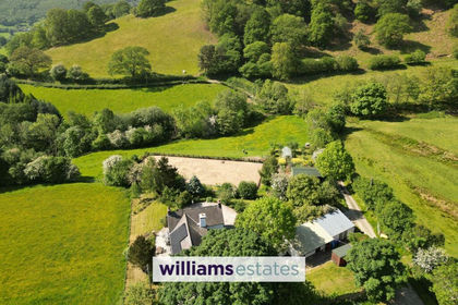
- Price
- Offers in Region of£695,000
- Size
- 10 acres
Added on 28/04/2026House with Land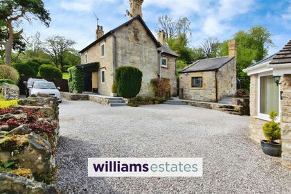
- Price
- Offers in Region of£583,000
- Size
- 3 acres
Rhydymwyn Road, Rhydymwyn, CH7, Cilcain, Flintshire CH7 Wales
Added on 01/02/2026House with Land