Somersham, Nr Ipswich, Suffolk
- Land size
- 36.5 acres
- Bedrooms
- 3
- Bathrooms
- 2
Description
Summary
The House - Reception hall, kitchen, sitting room, dining room, utility room and downstairs shower room. Three first floor bedrooms and bathroom.
Excellent range of relatively modern buildings and concrete yard that include nine loose boxes, three large pens, a tack room, feed store, general stores and a 60m x 20m Chaplestone manege.
Grounds including paddocks and agricultural land extending to approximately 36.5 acres.
Location
The property lies in a pleasant rural position between the villages of Somersham, Flowton, Elmsett and Offton. The property is within easy reach of all the villages where there are local pubs and shops. The county town of Ipswich is just 8 miles and here there are a wide range of shops, educational recreation facilities as well as a mainline railway station with services to London’s Liverpool Street station. The property is within easy reach of the A12/A14 and Hintlesham Hall with its hotel, spa and 18 hole golf course is 5 miles.
Description
Gunns Farm is a particularly special property that is ideal for someone looking for a small farm or equestrian facilities. The grounds in total extend to approximately 36.5 acres and the Grade II Listed farmhouse sits immediately adjacent to the yard where there are a number of outbuildings that are set up for equestrian purposes, along with a manege.
The House - The pretty house, which is of timber frame construction with rendered elevations under a peg tile roof, is Grade II Listed. It is understood that it was Listed in 1986 and the dwelling is believed to date from the late 16th century or early 17th century. A porch leads to a front door which opens to the reception hall. Here there are stairs to the first floor landing and doors off to the sitting room and kitchen. The kitchen is fitted with bespoke solid wood high and low-level wall units along with a granite worksurface and inset double butler sink with space and plumbing for a slimline dishwasher, a fridge freezer and an electric oven with gas connection. It has north-east and south-east facing windows. A door leads to an inner lobby where there are useful pantry cupboards, a door to the utility room and to the downstairs shower room. This has been refurbished in recent years and is fully tiled and comprises a shower, WC and handwash basin with cupboard below. The utility room has wall units, space and plumbing for a washing machine and tumble dryer as well as a mains gas-fired boiler that was installed in 2022. There is a window to the rear of the property and a door to the exterior. From the reception hall a door opens to a dual aspect sitting room where there are south-east and north-west facing windows to the front and rear. A brick fireplace is home to a woodburning stove flanked on one side by a shelved alcove. The room has exposed timbers. A door opens to the dining room which has a south-east facing window to the front with views over the garden and fields beyond. There is a blocked mullion window, exposed timbers and a fireplace. From the first floor landing is access to the bedrooms and bathroom. Bedroom three has a south-east facing window. The bathroom has a roll top bath, WC and handwash basin. Bedroom two, which is a walk-through to the principal bedroom has south-east and north-west facing windows to the front and rear as well as a built-in cupboard. Bedroom one is dual aspect with south-east and south-west facing windows.
The Yard and Buildings - The property is approached from the small lane via a driveway leading to the house, yard and buildings. Building one is of steel construction with part block and part timber elevations under a corrugated roof. In total it measures 18m x 11.7m. It contains eight loose boxes. Building two, which is used for general storage and is home to the office, feed store, tack room and a loose box, measures in total 18m x 15m. This is of timber frame construction with part brick and block elevations with the upper half being timber clad under a corrugated roof. It is open to the front. Beyond this is building three. This is a Dutch barn and predominantly open to the sides. As well as open storage, it has three large horse pens. It measures approximately 18m x 16.5m. It is of steel construction under a corrugated roof. In addition is a useful store of metal sheet construction which is split into two areas. In total the building measures approximately 12m x 5.5m. This is home to the borehole water filtration plant. Beyond the substantial concrete yard is the manege. This was installed by Chaplestone and has a rubber and sand base and is fully fenced.
The Land - The land surrounds the house, yard, buildings and manege. To the side and rear of the house are the more formal gardens which are laid to grass and contain beds. Here there are two ponds. In total the grounds extend to approximately 36.5 acres. As well as paddocks (approximately 13 acres) there is a belt of young native trees along with an area of mature woodland and birdseed/nectar mix. The grounds are enclosed by predominantly hedges and fencing.
Directions
Travelling from the A14, exit at junction 52 for Claydon. Travel south on the Bramford Road towards Bramford, turning right onto Pound Lane just before the Suffolk Water Park. This road leads into Somersham Road, through Little Blakenham. Continue through the village of Somersham. After the Duke of Marlborough Public House turn left onto Elmsett Road which leads onto Offton Road. Gunns Farm will be found on the right hand side.
What3Words: ///lots.highly.flies
Viewing Strictly by appointment with the agent.
Services Mains electricity. Mains gas with gas-fired central heating with a new boiler installed in 2022. Borehole water with a new borehole installed in 2025 and new filtration plant installed in February 2026. Modern sewage treatment plant.
Broadband To check the broadband coverage available in the area click this link –
Mobile Phones To check the mobile phone coverage in the area click this link –
EPC Rating = D (Copy available from the agents upon request).
Council Tax Band E; £2,093.47 payable per annum 2026/2027
Local Authority Mid Suffolk District Council, Endeavour House, 8 Russell Rd, Ipswich IP1 2BX; Tel:
NOTES
1. Every care has been taken with the preparation of these particulars, but complete accuracy cannot be guaranteed. If there is any point, which is of particular importance to you, please obtain professional confirmation. Alternatively, we will be pleased to check the information for you. These Particulars do not constitute a contract or part of a contract. All measurements quoted are approximate. The Fixtures, Fittings & Appliances have not been tested and therefore no guarantee can be given that they are in working order. Photographs are reproduced for general information and it cannot be inferred that any item shown is included. No guarantee can be given that any planning permission or listed building consent or building regulations have been applied for or approved. The agents have not been made aware of any covenants or restrictions that may impact the property, unless stated otherwise. Any site plans used in the particulars are indicative only and buyers should rely on the Land Registry/transfer plan.
2. The Money Laundering, Terrorist Financing and Transfer of Funds (Information on the Payer) Regulations 2017 require all Estate Agents to obtain sellers’ and buyers’ identity.
3. The vendor has completed a Property Information Questionnaire about the property and this is available to be emailed to interested parties.
4. The birdseed and nectar mix must remain in situ until December 2026.
5. The northern part of the property is included in the Norwich to Tilbury corridor for the proposed overhead electricity route. It is believed that one new pylon, which will be up to 55m in height will be situated on the land with some of the telegraph poles within the grounds being undergrounded. The agents have a plan showing the current proposal which can be emailed to interested parties. To view the interactive map for the proposed route please visit NorwichtoTilburymap.nationalgrid.com/2025.
6. It is not known whether the corrugated roofs of the buildings are asbestos or fibre cement.
7. The plan within these particulars shows the property outlined in red. Some retained land/the neighbouring land has a right of way over the track shaded purple and a right to improve the track.
August 2026
Map Location
Property details
- Tenure
- Freehold
- Council Tax Band
- E
- Date Posted
- 2026-08-06
Market Value Analysis
Compared with 17 Homes with Land listings in East Anglia (25+ acres).
Utilities & Restrictions
Utilities
- Electricity
- Mains
- Water
- Private Supply
- Heating
- Gas Heating
- Broadband
- Ask Agent
- Sewerage
- Septic Tank / Private
Rights & Restrictions
- Public Rights of Way
- Ask Agent
- Private Rights of Way
- Ask Agent
- Listed Property
- Yes
- Restrictions
- Ask Agent
Listed status, conservation areas and planning constraints for this location are in the full report.
Property Features
- Accessibility
- Ask Agent
- Parking
- Off-Street Parking
- Garden
- Private Garden
Beyond the particulars: planning activity, flood history, heritage and ground risks, checked for this exact spot.
Connectivity
Broadband
Fastest speed available at this postcode
1.8 Gbps
Gigabit full fibre · available to 50% of premises
Suitable for
- 4K streaming on every screen
- Full-time home working
- Online gaming & big downloads
Mobile signal
Outdoor predictions; indoor signal depends on building materials.
Ofcom Connected Nations postcode-level predictions. Speeds and signal are modelled, not measured, and vary between addresses and providers.
Signal is the easy part. Planning activity, flood history and protected designations here are in the full report.
Nearest Schools
Primary
- Elmsett Church of England Primary School1 mileOfsted: Good *
- Ages
- 4 to 11
- Pupils
- 41
- Type
- Academy converter
- Faith
- Church of England
- Somersham Primary School1.5 milesOfsted: Good
- Ages
- 4 to 11
- Pupils
- 72
- Type
- Community school
- Ringshall School2.2 milesNo Ofsted rating
- Ages
- 4 to 11
- Pupils
- 117
- Type
- Academy converter
- Whatfield Church of England Voluntary Controlled Primary School3.1 milesOfsted: Good
- Ages
- 5 to 11
- Pupils
- 44
- Type
- Voluntary controlled school
- Faith
- Church of England
- Hintlesham and Chattisham Church of England Primary School3.4 milesOfsted: Good
- Ages
- 5 to 11
- Pupils
- 67
- Type
- Academy converter
- Faith
- Church of England
Secondary
- Hadleigh High School4.1 milesNo Ofsted rating
- Ages
- 11 to 16
- Pupils
- 712
- Type
- Academy converter
- Claydon High School4.4 milesOfsted report card · Dec 2025
- Ages
- 11 to 16
- Pupils
- 765
- Type
- Academy converter
- Ormiston Endeavour Academy5.3 milesNo Ofsted rating
- Ages
- 11 to 16
- Pupils
- 793
- Type
- Academy sponsor led
- Chantry Academy5.9 milesOfsted: Good
- Ages
- 11 to 16
- Pupils
- 1,006
- Type
- Academy sponsor led
- Stoke High School - Ormiston Academy6.7 milesOfsted report card · Jun 2026
- Ages
- 11 to 16
- Pupils
- 811
- Type
- Academy sponsor led
* Latest graded judgement covers quality of education only; no overall grade was issued under the 2024-25 inspection framework.
Distances are straight-line from the advertised location. Source: the national school registers (DfE, Welsh Government, Scottish Government) and Ofsted.
Schools are just the start: sold prices nearby, planning activity and any flood history are in the full report.
Amenities
Supermarket
GP surgery
Pharmacy
Hospital
Straight-line distances from the advertised location. Sources: NHS records, Geolytix supermarket locations, OS Open Greenspace and the national trails registers.
The area stacks up? Now check the location itself: planning nearby, protected designations and past flooding.
Getting Around
Nearest station
Nearest bus stop
Typical drive times
Straight-line distances from the advertised location; drive times are typical free-flow times over OpenStreetMap road data, so allow more at peak. Public transport locations from DfT NaPTAN.
Easy to reach matters. So do planning activity, flood history and ground risks: all in the full report.
Flood Risk
From Environment Agency flood map open data, checked around the advertised map pin and allowing for the listed acreage where known. This summary comes from LandSale, the advertising platform, not from the listing agent, and is not part of the agent's particulars. Risk can vary across a single holding, so verify anything critical through your own searches before committing.
Rivers and the sea
Surface water
Mapped within the area searched, not at the advertised map pin itself.
These bandings are the summary. Where this location sits on the flood maps, plus planning activity, heritage and ground risks, is in the full report.
Important notice: Information, maps and tags on this page are drawn from the advertising agent's marketing materials or generated automatically. LandSale has not verified them. Relying on these details is at your own risk, always carry out independent checks before committing to a purchase.
LandSale full disclaimer
Marketing information only - not formal particulars. The details on this website are provided for general guidance and do not constitute an offer or contract. Neither LandSale nor the advertising estate/land agent accepts responsibility for any inaccuracy.
1. Source of information
- Listing content: Core description, asking price, tenure, measurements, photographs and planning history originate from the marketing materials of the advertising estate or land agent. LandSale does not author this content and cannot guarantee its accuracy.
- Automated tags & categorisation: Property type, land-use class, acreage bands and similar labels may be applied by machine-learning models. They are intended as a helpful guide only and may not reflect the property's legal status or permitted use.
- Third-party & enriched data layers: Maps, boundary outlines, planning designations, soil reports, broadband coverage and other environmental or location-based insights are licensed from external suppliers. Such data are supplied “as is", may be incomplete or out of date and are subject to change without notice.
2. Verification required
Prospective purchasers must verify critical matters, including but not limited to planning permission, title boundaries, public rights of way, environmental constraints, acreage, services, access and VAT status, through their own inspections, specialist surveys, legal advisers and the selling agent before relying on the information or entering into any contract.
3. No warranty or liability
LandSale gives no warranty, express or implied, as to the accuracy, completeness or fitness for any particular purpose of the information displayed. LandSale shall not be liable for any loss, damage, cost or expense arising directly or indirectly from any use of or reliance on such information, save where liability may not be excluded by law.
4. Updates & feedback
If you believe any detail on this listing is inaccurate, please let us know. We will investigate and, where appropriate, update the listing or notify the agent.
© LandSale | Version 1.3 - August 2026
Listing agent
Clarke and Simpson, Framlingham
Well Close Square, Framlingham, IP13 9DU
View agent profileSimilar properties for sale
- Price
- £1,350,000
- Size
- 2.92 acres
Added on 11/08/2026House with Land
- Price
- Guide Price£800,000
- Size
- 2.91 acres
Added on 07/05/2026Cottage
- Price
- Guide Price£1,200,000
- Size
- 3 acres
Ringshall, Stowmarket, suffolk, Ringshall, Suffolk IP14 England
Added on 01/08/2026House with Land
- Price
- £1,450,000
- Size
- 9.69 acres
Tye Lane, Bramford Tye, Ipswich, IP8, Bramford, Suffolk IP8 England
Added on 15/07/2026House with Land
- Price
- £1,250,000
- Size
- 3.5 acres
Added on 28/06/2026House with Land
- Price
- Offers in Excess of£750,000
- Size
- 0.5 acres
Duke Street, Hintlesham, Ipswich, Suffolk, IP8, Hintlesham, Suffolk IP8 England
Added on 03/07/2026Barn Conversion
- Price
- £875,000
- Size
- 2.3 acres
Nedging Road, Nedging Tye, IP7, Nedging-with-Naughton, Suffolk IP7 England
Added on 21/05/2026Country Home
- Price
- Guide Price£975,000
- Size
- 1 acres
Added on 29/01/2026Country Home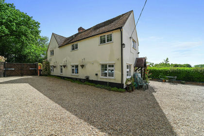
- Price
- Offers in Excess of£750,000
- Size
- 1.25 acres
Added on 29/05/2026House with Land
- Price
- Guide Price£799,950
- Size
- 3.73 acres
Wharfedale, Pond Hall Road, Hadleigh, Hadleigh, Suffolk IP7 England
Added on 27/08/2026House with Land