The Garn Fawr Lot 3, Llanhennock, Monmouthshire, NP18
- Land size
- 1.03 acres
- Bedrooms
- 3
- Bathrooms
- 1
Key Features
- Superb accessible location in south-west Monmouthshire in a beautiful position
- Great accessibility to Junction 24 of the M4 Motorway and the A449 at The Coldra Roundabout
- Impressive detached three-bedroom residence known as Lower Garn
- Range of traditional outbuidlings including a detached Grade II Listed traditional stone barn with potential
- Extending in total to 1.03 acres (0.42 hectares) Offered as one of three possible Lots
- Lower Garn is currently tenented
- Offered Freehold and subject to Tenancy
- Lot 1 Garn Fawr house & buildings including traditinal barn with extant planning, land and woodland extending to 17.06 acres (6.90 hectares)
- Lot 2 Upper Garn Bungalow, farm buildings and land extending to 276.09 acres (111.73 hectares)
Description
The Garn Fawr Lot 3 offers a fantastic opportunity to purchase a recently rennovateded detached country property known as Lower Garn within south-west Monmouthshire combining a picturesque setting, a three bedroom detached dwelling known as Lower Garn, a range of traditiolnal outbuilodings and detached traditiolan Grarde II Listed Barn extending in total to 1.03 acres (0.42 hectares). The Garn Fawr Lot 3 will be of interest to anyone with lifestyle, and possible development interests and is available as one of three possible Lots.
The Garn Fawr Lot 3 is extremely well located within the south-west Monmouthshire countryside but with excellent road access to Junction 24 of the M4 Motorway less than 15 minutes away. Positioned in a peaceful situation with beautiful views over the River Usk and surrounding landscape, The Garn Fawr Lot 3 will be of interest to anyone with lifestyle and development interests.
OFFERED FOR SALE AS ONE OF THREE LOTS
• Superb accessible location in south-west Monmouthshire in a beautiful position •
• Great accessibility to Junction 24 of the M4 Motorway and the A449 at The Coldra Roundabout •
• Impressive detached three-bedroom residence known as Lower Garn •
• Range of traditional outbuidlings including a detached Grade II Listed traditional stone barn with potential •
• Extending in total to 1.03 acres (0.42 hectares) Offered as one of three possible Lots •
• Lower Garn is currently tenented •
• Lot 1 Garn Fawr house & buildings including traditinal barn with extant planning, land and woodland extending to 17.06 acres (6.90 hectares) • • Lot 2 Upper Garn Bungalow, farm buildings and land extending to 276.09 acres (111.73 hectares). •
Llanhennock 3 miles • Caerleon 4.2 miles • Usk 6.3 miles • Newport 8.2 miles
Cwmbran 9.3 miles • Raglan 11.8 miles • Abergavenny 17.8 miles • Chepstow 18.1 miles
Cardiff 18.5 miles • Monmouth 19.1 miles • Bristol 32 miles • London 139 miles
Newport Railway Station 7.8 miles • Cardiff Airport 32.6 miles • Bristol Airport 35.5 miles
London Heathrow Airport 125 miles
(all distances are approximate)
LOCATION & SITUATION
Garn Fawr Lot 3 is surrounded by glorious Monmouthshire countryside in a picturesque setting with wonderful outlook over the river Usk. Located just 6.3 miles from the town of Usk to the north and 4.2 miles from Caerleon to the south-west the property is within easy access of the main road links to the Usk Road, A48, A449 and on to the M4/M48, M5 and M50 motorway networks. The cities of Cardiff, Bristol and Hereford are all within an hour’s drive and connections to main line trains, reaching London Paddington in under 2 hours, can be found at the railway station in Newport just 7.8 miles from the property. Surrounding the town of Usk is beautiful countryside and the Usk Valley with an abundance of walks and outdoor activities.
Caerleon is just 4.2 miles from the property and is a thriving Roman town with fantastic archaeological features including the roman barracks, roman baths and an amphitheatre. The Priory Hotel and Restaurant, a 12th century Cistercian monastery full of history and character offers fine dining and overnight accommodation. The town also has primary and secondary schools and neighbours the Celtic Manor Resort and Golf Club, home to the 2010 Ryder Cup offering a challenging course with fantastic views.
The town of Usk is just 6.3 miles north of the property, with an array of good bars and cafes, the picturesque Usk Castle, Morris’ of Usk Garden Centre, the Glen Yr Afon House Hotel and Cwrt Bleddyn Hotel and Spa.
Newport is just 8.2 miles away from the property with all the benefits a city has to offer, such as Friars Walk Shopping Centre, a railway station offering direct trains to London, bus station, cafes and restaurants. Tredegar House is a National Trust 17th century country mansion and gardens located at the western edge of Newport. Rougemont is an independent school located in Newport and described by them as a ‘School for Life’ and for the 21st Century.
Cardiff is 18.5 miles to the west offering all the amenities of a capital city with an abundance of schools, colleges and excellent tertiary education institutions including the world-renowned Cardiff University, Cardiff Metropolitan University and the Royal Welsh College of Music and Drama. The city offers fantastic shopping and hospitality with multiple arcades and the renovated St David’s 2 shopping centre and international sports venues in the Principality Stadium, Cardiff City Stadium and Sophia Gardens Cricket Ground.
Monmouth is located just 19.1 miles from the property and boasts excellent schools including Haberdashers’ Monmouth School, Llangattock School Monmouth with Montessori Nursery, a variety of primary schools and Monmouth Comprehensive School. Monmouth also offers an upmarket traditional shopping street, with boutique shops, Waitrose supermarket, M&S Simply Food, The Savoy Theatre and an extensive range of recreational and leisure facilities. An abundance of tourism and recreational activities exist within Monmouth and the wider region.
LOWER GARN
Positioned below Garn Fawr and directly accessed from an independent drive from the Glen Usk Road is the fully detached property known as Lower Garn. Lower Garn is a charming, detached country property featuring stone elevations under a pitched slate roof. To the front is a parking area for two vehicles with walled front garden and steps leading up to the property. The front door opens into the front hall. On the left is the sitting room with tiled floor, single aspect window to the front and feature fireplace. Directly opposite the front door from the front hall is the cloakroom with wc and wash basin. To the right is the open plan kitchen and dining area with tiled floor, base units, granite worktop, metal sink, Bosh electric oven, John Lewis hob and island opening out into the dining area with space for a dining table, fully enclosed larder, and doors to the front and rear. Last is the utility with tiled floor, base units, sink and single aspect window to the front.
Stairs from the side of the kitchen lead up to the 1st floor accommodation. Bedroom one is a double with carpeted floor, exposed beams and single aspect window to the side. Next is the family bathroom with bath, wc, wash basin and tiled floor. Directly opposite on the other side of the landing is a shower room with walk-in shower. Bedroom two is a large double with double aspect windows to the front and rear with feature fireplace and carpeted floor. Last is the principal bedroom a double with carpeted floor and double aspect windows to the front and rear.
Outside, directly to the west of the house is an impressive fully enclosed Grade II Listed traditional stone barn. Positioned directly north is a courtyard garden area with a range of single storey barns to the rear and western side providing a charming outside entertaining space. The barns all have potential for multiple possible uses subject to obtaining the necessary planning consents. The property features a paddock to the north of the barns and garden area to the east and west of the property with a small section of woodland to the south.
Lower Garn is currently Tenanted under an Occupation Contract with a rent of £1,600 per calendar month. In terms of services the property is connected to mains electricity, private water supply from the borehole and foul drainage to a septic tank.
The property offers an excellent detached country property with barns with development potential in a picturesque location. It would certainly appeal to lifestyle and development purchasers.
In all Garn Fawr Lot 3 extends in total to approximately 1.03 acres (0.42 hectares).
KEY INFORMATION
Services: Private water (borehole) shared with all properties, mains electricity and private drainage to a septic tank). Heating is by way of an oil-fired boiler. Broadband is available and connected.
Tenure: Freehold Subject to Tenancy.
Sale Method: Private Treaty
Rental Income: Please contact the selling agent for more information.
Energy Performance Certificates (EPC): Lower Garn – E
Wayleaves, Easements and Rights of Way: The property is offered with all existing wayleaves, easements and all public and private rights of way and other such rights, whether these are specifically referred to in these particulars or not.
Fixtures and Fittings: Only those items specifically mentioned in these particulars will be included in the sale, the remainder are excluded from the sale, however, may be available by separate negotiation.
Council Tax Bands: Lower Garn – G
Local Authority: Monmouthshire County Council. Telephone: 01633 644644.
Viewings: Strictly by appointment with the selling agents on set viewing days.
Directions: From Junction 25A of the M4 take the exit from the Caerleon Interchange take the exit onto the Caerleon Road B4596. Proceed for 1.5 miles crossing over the Usk at Caerleon Bridge. Then proceed onto the High Street/B4236 for 0.6 miles. At the roundabout take the second exit onto Usk Road. Proceed on the Usk Road which will then turn into Glen Usk road for approximately 3.2 miles then the property will be on your left.
Postcode: NP18 1LU
What3Words: ///tickles.paper.patching
Map Location
Property details
- Tenure
- Freehold
- Council Tax Band
- Ask Agent
- Date Posted
- 2026-08-05
Market Value Analysis
Compared with 1,041 Homes with Land listings in Wales (1+ acres).
Utilities & Restrictions
Utilities
- Electricity
- Ask Agent
- Water
- Ask Agent
- Heating
- Ask Agent
- Broadband
- Ask Agent
- Sewerage
- Ask Agent
Rights & Restrictions
- Public Rights of Way
- Ask Agent
- Private Rights of Way
- Ask Agent
- Listed Property
- Ask Agent
- Restrictions
- Ask Agent
Listed status, conservation areas and planning constraints for this location are in the full report.
Property Features
- Accessibility
- Ask Agent
- Parking
- Parking Available
- Garden
- Garden
Beyond the particulars: planning activity, flood history, heritage and ground risks, checked for this exact spot.
Connectivity
Broadband
Fastest speed available at this postcode
45 Mbps
Gigabit full fibre · available to 76% of premises
Suitable for
- HD streaming
- Video calls
- Web & social
Fixed wireless access may also be an option here.
Mobile signal
Predicted 4G and 5G signal; indoor signal depends on building materials.
Ofcom Connected Nations postcode-level predictions. Speeds and signal are modelled, not measured, and vary between addresses and providers.
Signal is the easy part. Planning activity, flood history and protected designations here are in the full report.
Nearest Schools
Primary
- Langstone Primary School1.7 miles
- Pupils
- 346
- Type
- Nursery, Infants & Juniors
- Language
- English medium school / provision
- Charles Williams Church In Wales Primary School2 miles
- Pupils
- 515
- Type
- Nursery, Infants & Juniors
- Language
- English medium school / provision
- Ysgol Gymraeg Nant Gwenlli2.2 miles
- Pupils
- 40
- Type
- Nursery & Infants
- Language
- Welsh medium school / provision (including transitional)
- Caerleon Lodge Hill Primary2.3 miles
- Pupils
- 317
- Type
- Nursery, Infants & Juniors
- Language
- English medium school / provision
- Milton Primary School2.3 miles
- Pupils
- 469
- Type
- Nursery, Infants & Juniors
- Language
- English medium school / provision
Secondary
- Caerleon Comprehensive School2.2 miles
- Pupils
- 1,471
- Type
- Secondary (ages 11-19)
- Language
- English medium school / provision
- Llanwern High School3 miles
- Pupils
- 1,101
- Type
- Secondary (ages 11-19)
- Language
- English medium school / provision
- St Julian's School3.1 miles
- Pupils
- 1,426
- Type
- Secondary (ages 11-19)
- Language
- English medium school / provision
- Croesyceiliog School4.1 miles
- Pupils
- 1,185
- Type
- Secondary (ages 11-16)
- Language
- English medium school / provision
- Lliswerry High School4.2 miles
- Pupils
- 1,079
- Type
- Secondary (ages 11-19)
- Language
- English medium school / provision
Distances are straight-line from the advertised location. Source: the national school registers (DfE, Welsh Government, Scottish Government) and Ofsted.
Schools are just the start: sold prices nearby, planning activity and any flood history are in the full report.
Amenities
Supermarket
GP surgery
Pharmacy
Straight-line distances from the advertised location. Sources: NHS records, Geolytix supermarket locations, OS Open Greenspace and the national trails registers.
The area stacks up? Now check the location itself: planning nearby, protected designations and past flooding.
Getting Around
Nearest station
Nearest bus stop
Typical drive times
Straight-line distances from the advertised location; drive times are typical free-flow times over OpenStreetMap road data, so allow more at peak. Public transport locations from DfT NaPTAN.
Easy to reach matters. So do planning activity, flood history and ground risks: all in the full report.
Flood Risk
Natural Resources Wales open data, checked around the advertised map pin for the listed acreage. Long-term risk counts flood defences; the planning map's flood zones do not. Provided by LandSale, not the listing agent, and not part of the agent's particulars. Risk varies across a holding, so verify before committing.
Rivers and the sea
Planning map: Flood Zone 1.
Surface water
Not at the pin: mapped about 30 metres away.
These bandings are the summary. Where this location sits on the flood maps, plus planning activity, heritage and ground risks, is in the full report.
Important notice: Information, maps and tags on this page are drawn from the advertising agent's marketing materials or generated automatically. LandSale has not verified them. Relying on these details is at your own risk, always carry out independent checks before committing to a purchase.
LandSale full disclaimer
Marketing information only - not formal particulars. The details on this website are provided for general guidance and do not constitute an offer or contract. Neither LandSale nor the advertising estate/land agent accepts responsibility for any inaccuracy.
1. Source of information
- Listing content: Core description, asking price, tenure, measurements, photographs and planning history originate from the marketing materials of the advertising estate or land agent. LandSale does not author this content and cannot guarantee its accuracy.
- Automated tags & categorisation: Property type, land-use class, acreage bands and similar labels may be applied by machine-learning models. They are intended as a helpful guide only and may not reflect the property's legal status or permitted use.
- Third-party & enriched data layers: Maps, boundary outlines, planning designations, soil reports, broadband coverage and other environmental or location-based insights are licensed from external suppliers. Such data are supplied “as is", may be incomplete or out of date and are subject to change without notice.
2. Verification required
Prospective purchasers must verify critical matters, including but not limited to planning permission, title boundaries, public rights of way, environmental constraints, acreage, services, access and VAT status, through their own inspections, specialist surveys, legal advisers and the selling agent before relying on the information or entering into any contract.
3. No warranty or liability
LandSale gives no warranty, express or implied, as to the accuracy, completeness or fitness for any particular purpose of the information displayed. LandSale shall not be liable for any loss, damage, cost or expense arising directly or indirectly from any use of or reliance on such information, save where liability may not be excluded by law.
4. Updates & feedback
If you believe any detail on this listing is inaccurate, please let us know. We will investigate and, where appropriate, update the listing or notify the agent.
© LandSale | Version 1.3 - August 2026
Listing agent
Powells, Monmouth
Singleton Court Business Park, Wonastow Road, Monmouth, NP25 5JA
Contact Powells, Monmouth
Singleton Court Business Park, Wonastow Road, Monmouth, NP25 5JA
View agent profileSimilar properties for sale
- Price
- Guide Price£795,000
- Size
- 1 acres
Usk Road, Caerleon, NP18, Llangybi, Monmouthshire NP18 Wales
Added on 11/07/2026House with Land
- Price
- £1,000,000
- Size
- 29 acres
Llantrisant, Usk, NP15, Llantrisant Fawr, Monmouthshire NP15 Wales
Added on 29/01/2026Small Farm
- Price
- Guide Price£930,000
- Size
- 1.1 acres
St. Brides, Netherwent, Caldicot, Caerwent, Monmouthshire NP26 Wales
Added on 29/01/2026Country Home
- Price
- £760,000
- Size
- 2.95 acres
Added on 12/04/2026Cottage
- Price
- £800,000
- Size
- 1 acres
Added on 28/01/2026Barn Conversion
- Price
- Guide Price£745,000
- Size
- 1 acres
Broad street Common, Newport, NP18, Nash, Newport NP18 Wales
Added on 29/01/2026Barn Conversion
- Price
- Offers in Region of£745,000
Chapel Barn, Broad Street Common, Nash, Newport, Nash, Newport NP18 Wales
Added on 03/09/2026Barn Conversion
- Price
- Guide Price£750,000
- Size
- 1 acres
Added on 17/07/2026House with Land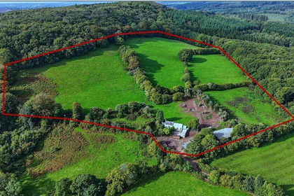
- Price
- Offers in Region of£750,000
- Size
- 20.54 acres
Llanvair Discoed, Chepstow, Monmouthshire, NP16, Caerwent, Monmouthshire NP16 Wales
Added on 06/10/2026Smallholding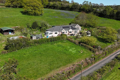
- Price
- Offers in Region of£750,000
- Size
- 5 acres
Added on 17/08/2026House with Land