Llanvair Discoed, Chepstow, Monmouthshire, NP16
- Land size
- 20.54 acres
Key Features
- Grade II Listed 3-bedroom Cottage in need of renovation (STP)
- Adjoining Grade II Listed Traditional Stone Barn
- Modern Agricultural Buildings
- 20.54 acres of pasture
- Elevated position with far reaching countryside views
- Available as a Whole with Offers in the Region of £750,000
Description
Coming to the market for the first time in over 80 years, Gilvynog (also known as Cilvaynog) presents a rare opportunity to acquire a traditional rural smallholding in an elevated and highly desirable setting within the picturesque countryside of Llanvair Discoed. At its heart is a charming Grade II Listed country cottage, offering considerable scope for sympathetic refurbishment and enhancement, subject to the necessary consents. Complemented by a range of agricultural outbuildings and set within approximately 20.54 acres (8.31 hectares) of land, the property combines character, privacy and potential, making it an exceptional lifestyle, equestrian or smallholding opportunity.
DESCRIPTION
Believed to date from the mid-18th Century, Gilvynog is a detached stone cottage of considerable character and historic charm. Occupying an attractive rural setting, the property is arranged over two storeys beneath a distinctive part slate, part stone-tiled roof. Both the cottage and adjoining stone barn are Grade II Listed, reflecting their architectural and heritage significance. While the property now requires comprehensive renovation and modernisation, it presents an exciting opportunity for purchasers to restore and enhance a traditional country cottage, creating a truly unique opportunity.
SITUATION
Gilvynog occupies an elevated rural position on the outskirts of the highly sought-after village of Earlswood, enjoying far-reaching views across the surrounding Monmouthshire countryside. The property lies approximately 8 miles west of the market town of Chepstow and 9.5 miles south-east of Usk, providing an attractive balance between peaceful country living and convenient access to a comprehensive range of amenities. The nearby village of Shirenewton, situated approximately 3 miles to the east, offers a range of everyday facilities including a public house, church, primary school and recreational amenities. A wider selection of services can be found in Chepstow, Caldicot and Usk, including supermarkets, independent retailers, healthcare facilities, leisure centres and secondary education establishments. The area is renowned for its attractive countryside and recreational opportunities. Nearby attractions include the historic Wye Valley Area of Outstanding Natural (truncated)
OUTSIDE
The property enjoys generous gardens, with mature trees and shrubs providing an attractive frontage. Access is provided via a driveway with circular turning area set at a lower position to the dwellinghouse providing an attractive entrance.
Land
The property includes a ring-fenced block of permanent pasture extending to approximately 20.27 acres (8.20 ha). The land gently slopes and adjoins both Greyhill and Wentwood Forest to the north, benefiting from a sheltered position. Boundaries are formed by mature tree lines and stock fencing, and the land is considered suitable for livestock grazing. In addition, the property enjoys valuable common grazing rights across Bica Common, permitting the grazing of up to 14 cattle and 35 sheep.
Land Schedule
Please see Field Schedule in Photos
BUILDINGS
A range of traditional and modern agricultural buildings are situated on the holding, including an adjoining traditional stone barn (52.68m²) which may offer potential for future conversion or development, subject to obtaining the necessary planning consents. Additional buildings comprise traditional stone and block-built pig cots (32.51m²), a general-purpose agricultural building (453.55m²), and a pole barn with adjoining lean-to extensions (170.30m²), providing a range of storage and livestock accommodation.
ACCESS
Gilvynog is accessed via a single-track lane extending from Chapel Road, Earlswood, and crossing Bica Common.
TENURE
Freehold with vacant possession upon completion.
BOUNDARIES
The purchaser shall be deemed to have full knowledge of the boundaries and neither the Vendor nor the Agent should be required to produce evidence as to the ownership of the boundaries.
EASEMENTS, COVENANTS & RIGHTS OF WAY
The property is sold subject to any rights, benefits or incidents of tenure which affect it.
SERVICES
The property benefits from a mains electricity connection. Water is supplied via a private borehole, with oil fired heating provided. Foul drainage is served by a private drainage system.
COUNCIL TAX BAND
Gilvynog has a Council Tax Banding of E.
LOCAL AUTHORITY
Monmouthshire County Council –
LOTTING & RESERVE
It is anticipated that the property will be offered as shown but the Vendor reserves the right to withdraw, alter or amend the extent of the property being offered.
DIRECTIONS
From Chepstow, take the A48 westbound towards Newport and, at Crick, turn right onto Crick Road, signposted for Shirenewton. Proceed through the village of Shirenewton and continue for approximately 1 mile before taking the left-hand fork signposted Earlswood/West End. After approximately 0.5 miles, turn left onto School Road and follow the road around the triangle junction onto Chapel Road. Continue for a further quarter of a mile before taking the next left-hand turn. Follow this lane, crossing the stream, and at the fork bear left. Continue along the lane, where the property will be found further ahead. When travelling from Usk, take the B4235 south towards Shirenewton and Chepstow. After approximately 6 miles, turn right at the Gaerllwyd crossroads towards Earlswood and immediately bear right past the chapel. Continue for approximately 0.5 miles before taking the left-hand turn signposted Shirenewton/Earlswood, followed immediately by a right turn onto Chapel Road. (truncated)
VIEWING
Strictly by appointment with the Sole Selling Agents: David James. Please call our Magor office on . Whilst the property is readily accessible by most vehicles, interested parties are advised to exercise due care when travelling along the track, particularly during periods of adverse weather or where surface conditions may be uneven.
GUIDE PRICE
Offers in the Region of £750,000 (Seven Hundred and Fifty Thousand)
Map Location
Property details
- Tenure
- Freehold
- Council Tax Band
- TBC
- Date Posted
- 2026-10-06
Market Value Analysis
Compared with 217 Farms & Smallholdings listings in Wales (10+ acres).
Energy Performance Certificate
Energy Efficiency Rating
Based on UK Energy Performance Certificate standards (EU Directive 2002/91/EC)
Running costs are one side. Planning activity, flood history and ground risks for this location are in the full report.
Utilities & Restrictions
Utilities
- Electricity
- Ask Agent
- Water
- Ask Agent
- Heating
- Ask Agent
- Broadband
- Ask Agent
- Sewerage
- Ask Agent
Rights & Restrictions
- Public Rights of Way
- Ask Agent
- Private Rights of Way
- Ask Agent
- Listed Property
- Ask Agent
- Restrictions
- Ask Agent
Listed status, conservation areas and planning constraints for this location are in the full report.
Property Features
- Accessibility
- Ask Agent
- Parking
- Parking Available
- Garden
- Garden
Beyond the particulars: planning activity, flood history, heritage and ground risks, checked for this exact spot.
Connectivity
Broadband
Fastest speed available at this postcode
20 Mbps
Standard (10-30 Mbps)
Suitable for
- Web & social
- Music streaming
- Standard video calls
Mobile signal
Predicted 4G and 5G signal; indoor signal depends on building materials.
Ofcom Connected Nations postcode-level predictions. Speeds and signal are modelled, not measured, and vary between addresses and providers.
Signal is the easy part. Planning activity, flood history and protected designations here are in the full report.
Nearest Schools
Primary
- Shirenewton Primary School2.2 miles
- Pupils
- 197
- Type
- Infants & Juniors
- Language
- English medium school / provision
- Ysgol Gymraeg Y Ffin3.8 miles
- Pupils
- 157
- Type
- Nursery, Infants & Juniors
- Language
- Welsh medium school / provision (including transitional)
- Dewstow4 miles
- Pupils
- 204
- Type
- Nursery, Infants & Juniors
- Language
- English medium school / provision
- Rogiet County Primary4 miles
- Pupils
- 198
- Type
- Infants & Juniors
- Language
- English medium school / provision
- Castle Park Primary School4.1 miles
- Pupils
- 186
- Type
- Infants & Juniors
- Language
- English medium school / provision
Secondary
- Caldicot School4.3 miles
- Pupils
- 1,247
- Type
- Secondary (ages 11-19)
- Language
- English medium school / provision
- Chepstow Comprehensive School5.2 miles
- Pupils
- 860
- Type
- Secondary (ages 11-19)
- Language
- English medium school / provision
- Llanwern High School6.7 miles
- Pupils
- 1,101
- Type
- Secondary (ages 11-19)
- Language
- English medium school / provision
- Caerleon Comprehensive School7.1 miles
- Pupils
- 1,471
- Type
- Secondary (ages 11-19)
- Language
- English medium school / provision
- St Julian's School8 miles
- Pupils
- 1,426
- Type
- Secondary (ages 11-19)
- Language
- English medium school / provision
Distances are straight-line from the advertised location. Source: the national school registers (DfE, Welsh Government, Scottish Government) and Ofsted.
Schools are just the start: sold prices nearby, planning activity and any flood history are in the full report.
Amenities
Supermarket
GP surgery
Pharmacy
Straight-line distances from the advertised location. Sources: NHS records, Geolytix supermarket locations, OS Open Greenspace and the national trails registers.
The area stacks up? Now check the location itself: planning nearby, protected designations and past flooding.
Getting Around
Nearest station
Nearest bus stop
Typical drive times
Straight-line distances from the advertised location; drive times are typical free-flow times over OpenStreetMap road data, so allow more at peak. Public transport locations from DfT NaPTAN.
Easy to reach matters. So do planning activity, flood history and ground risks: all in the full report.
Flood Risk
Natural Resources Wales open data, checked around the advertised map pin for the listed acreage. Long-term risk counts flood defences; the planning map's flood zones do not. Provided by LandSale, not the listing agent, and not part of the agent's particulars. Risk varies across a holding, so verify before committing.
Rivers and the sea
Planning map: Flood Zone 1.
Surface water
These bandings are the summary. Where this location sits on the flood maps, plus planning activity, heritage and ground risks, is in the full report.
Important notice: Information, maps and tags on this page are drawn from the advertising agent's marketing materials or generated automatically. LandSale has not verified them. Relying on these details is at your own risk, always carry out independent checks before committing to a purchase.
LandSale full disclaimer
Marketing information only - not formal particulars. The details on this website are provided for general guidance and do not constitute an offer or contract. Neither LandSale nor the advertising estate/land agent accepts responsibility for any inaccuracy.
1. Source of information
- Listing content: Core description, asking price, tenure, measurements, photographs and planning history originate from the marketing materials of the advertising estate or land agent. LandSale does not author this content and cannot guarantee its accuracy.
- Automated tags & categorisation: Property type, land-use class, acreage bands and similar labels may be applied by machine-learning models. They are intended as a helpful guide only and may not reflect the property's legal status or permitted use.
- Third-party & enriched data layers: Maps, boundary outlines, planning designations, soil reports, broadband coverage and other environmental or location-based insights are licensed from external suppliers. Such data are supplied “as is", may be incomplete or out of date and are subject to change without notice.
2. Verification required
Prospective purchasers must verify critical matters, including but not limited to planning permission, title boundaries, public rights of way, environmental constraints, acreage, services, access and VAT status, through their own inspections, specialist surveys, legal advisers and the selling agent before relying on the information or entering into any contract.
3. No warranty or liability
LandSale gives no warranty, express or implied, as to the accuracy, completeness or fitness for any particular purpose of the information displayed. LandSale shall not be liable for any loss, damage, cost or expense arising directly or indirectly from any use of or reliance on such information, save where liability may not be excluded by law.
4. Updates & feedback
If you believe any detail on this listing is inaccurate, please let us know. We will investigate and, where appropriate, update the listing or notify the agent.
© LandSale | Version 1.3 - August 2026
Listing agent
David James, Magor
Court Barn, West End, Magor, Monmouthshire, NP26 3HT
Call agent
01633 880220Contact David James, Magor
Court Barn, West End, Magor, Monmouthshire, NP26 3HT
Call agent
01633 880220Similar properties for sale
- Price
- Guide Price£925,000
- Size
- 24.53 acres
Added on 29/01/2026Farm
- Price
- Offers in Region of£785,000
- Size
- 10 acres
Added on 25/05/2026Smallholding
- Price
- Guide Price£710,000
- Size
- 19.13 acres
Little Park Farm, Llanvihangel Crucorney, Abergavenny, NP7, Grosmont, Monmouthshire NP7 Wales
Added on 21/03/2026Barn Conversion
- Price
- Guide Price£860,000
- Size
- 24.71 acres
Bettws, Abergavenny, Monmouthshire, Crucorney, Monmouthshire NP7 Wales
Added on 01/10/2026Smallholding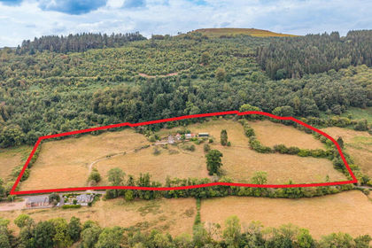
- Price
- Guide Price£675,000
- Size
- 14.67 acres
The Coed Lot 1, Cwmyoy, Abergavenny, Monmouthshire, NP7, Crucorney, Monmouthshire NP7 Wales
Added on 11/09/2026Smallholding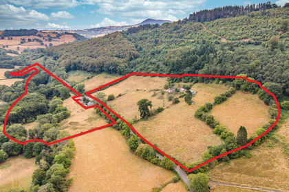
- Price
- Guide Price£875,000
- Size
- 30.97 acres
The Coed, Cwmyoy, Abergavenny, Monmouthshire, NP7, Crucorney, Monmouthshire NP7 Wales
Added on 11/09/2026Smallholding