Canal Side Property For Sale – Wanless Water Farm, Red Lane, Colne, BB8
- Land size
- 11 acres
- Bedrooms
- 3
Key Features
- A delightful canal side property
- Comprising a charming grade II listed detached three bedroom house
- With gardens and private parking
- Together with just over 11 acres of land
- With approximately 1km of moorings on the Leeds Liverpool Canal.
- Peaceful rural backwater setting off Red Lane, within easy reach of Barrowford, Colne and the M65 motorway.
- An additional 6.45 acres of land is available separately
Description
A delightful canal side property comprising a charming grade II listed detached three bedroom house with gardens and private parking together with just over 11 acres of land and approximately 1km of moorings on the Leeds Liverpool Canal.
Peaceful rural backwater setting off Red Lane, within easy reach of Barrowford, Colne and the M65 motorway.
An additional 6.45 acres of land is available separately.
Location
Wanless Water Farm enjoys a rural position on the northern edge of the resurgent town of Colne being accessed via a private drive from Red Lane. Colne provides a comprehensive range of services including supermarkets, independent shops, bars and eateries. There are various pre-schools, primary and secondary schools and there are excellent transport links by both rail and road with the M65 providing connections to the wider motorway network.
Description
Wanless Water Farm is a wonderfully versatile property that will appeal to a wide market including those with an interest in hobby farming, equestrian and conservation to those looking for a property that already generates and income with scope to expand further, subject to any additional permissions and consents that may be required.
This delightful waterside property comprises a grade II listed detached three bedroom house with adjoining lean-to store and cellar, having potential to extend subject to planning. There is an enclosed garden to the front with provision for private parking and just over 11 acres of productive meadow and pasture. Part of the land fronts directly onto the Leeds & Liverpool Canal providing approximately 1000 metres of registered moorings which are let on individual licences, generating an income of circa £7,500 pa.
The house is entered into a welcoming living room with open fireplace set in a stone surround with flagged hearth and feature stone benching to the alcoves either side. Oak boarded floor, beams to the ceiling, feature stone work incorporating shelves, enclosed staircase to the first floor with store below and mullion windows overlooking the garden and adjacent canal. There is a beautifully appointed kitchen with a range of painted base units, granite work surface and Belfast style sink with mixer tap and splash back. Integrated appliances include an electric range style cooker with induction hob, three ovens and grill, dishwasher, fridge and separate freezer. Tiled floor and beams to the ceiling. Off the kitchen is a very useful cellar with original stone banks and stone flag floor. A well appointed utility room provides a laminate work surface with stainless steel sink and drainer and tiled splash with base unit and space for a washing machine and tumble drier below. Laminate floor and external door.
The first floor landing with beam and borrowed natural light via leaded coloured glass windows gives way to three double bedrooms, each having mullion windows overlooking the garden and canal to the front with Bedroom 3 also having a window to the rear, overlooking the land. Bedroom 1 has a tasteful range of painted fitted wardrobes and drawers, providing plenty of storage. The house bathroom has a panelled bath with shower over, w.c, and large basin set on a base unit. Chrome towel rail, laminate floor, tiled and shower boarded walls.
Outside
Adjoining the house is a useful lean-to store housing the multi fuel central heating boiler and providing additional storage together with a separate w.c.
Extending in front of the house is a beautiful cottage style garden with flagged patio seating area opening onto a generous lawn with well stocked mature borders enclosed by a hedge and fencing. Private parking is within the yard to the side.
There is approximately 2.48 hectares (6.12 acres) of productive meadow and pasture extending to the north of the house having approximately 1000 metres of frontage to the Leeds & Liverpool Canal with certified moorings along the full length.
There is an additional field to the south of the property on the opposite side of the canal extending to about 2.02 hectares (4.99 acres) which is accessed from the lane and contains the hydraulic ram pumping system for the private water supply.
Additional Land Property
Directly opposite the house and moorings across the canal is a further field extending to about 2.61 hectares (6.45 acres) shown edged blue on the plan. The field is accessed directly from Red Lane and is available for sale by separate negotiation.
Across the yard from Wanless Water Farm is a stone barn with planning permission pending for conversion to a dwelling, a range of buildings and land extending to approximately 8.65 hectares (21.37 acres). This property is also currently for sale through David Hill LLP with full details available on request.
Services
Mains electricity, septic tank drainage, private water.
Energy Rating
F - 24
Tenure
Freehold.
Council Tax
Band D (Pendle Borough Council)
Viewings
Strictly by appointment with the selling agents.
Wayleaves, Easements and Rights of Way
The land is sold subject to all wayleaves, easements and rights of way both public and private which might affect the land.
Directions
From Skipton head west on the A59 taking the first exit at the Broughton roundabout onto the A56 signed to Colne. Continue through Thornton in Craven, Earby, Sough, Kelbrook and Foulridge turning right onto Longroyd Road after leaving Foulridge. At the roundabout take the third exit onto Red Lane and go straight across at the next roundabout. Continue for about 1.75km turning right down the private lane continuing over the canal bridge and bearing round to the right into the yard where the property is on the right, adjacent to the canal. A David Hill ‘For Sale' sign has been erected.
Map Location
Property details
- Tenure
- Freehold
- Council Tax Band
- Ask Agent
- Date Posted
- 2026-07-11
Price history
| Date | Change | Price |
|---|---|---|
| 8 Sep 2026 | Reduced 4.2% (−£25,000) | £575,000 |
| Until 8 Sep 2026 | Asking price | £600,000 |
Market Value Analysis
Compared with 89 Homes with Land listings in North West England (10+ acres).
Utilities & Restrictions
Utilities
- Electricity
- Ask Agent
- Water
- Ask Agent
- Heating
- Ask Agent
- Broadband
- Ask Agent
- Sewerage
- Ask Agent
Rights & Restrictions
- Public Rights of Way
- Ask Agent
- Private Rights of Way
- Ask Agent
- Listed Property
- Ask Agent
- Restrictions
- Ask Agent
Listed status, conservation areas and planning constraints for this location are in the full report.
Property Features
- Accessibility
- Ask Agent
- Parking
- Parking Available
- Garden
- Garden
Beyond the particulars: planning activity, flood history, heritage and ground risks, checked for this exact spot.
Connectivity
Broadband
Fastest speed available at this postcode
19 Mbps
Standard (10-30 Mbps)
Suitable for
- Web & social
- Music streaming
- Standard video calls
Mobile signal
Predicted 4G and 5G signal; indoor signal depends on building materials.
Ofcom Connected Nations postcode-level predictions. Speeds and signal are modelled, not measured, and vary between addresses and providers.
Signal is the easy part. Planning activity, flood history and protected designations here are in the full report.
Nearest Schools
Primary
- Blacko Primary School0.8 milesNo Ofsted rating
- Ages
- 4 to 11
- Pupils
- 103
- Type
- Academy converter
- Sacred Heart Roman Catholic Primary School, a Voluntary Academy1 mileNo Ofsted rating
- Ages
- 5 to 11
- Pupils
- 216
- Type
- Academy converter
- Faith
- Roman Catholic
- Colne Lord Street School1 mileOfsted: Good
- Ages
- 4 to 11
- Pupils
- 327
- Type
- Academy converter
- Colne Primet Primary School1.2 milesOfsted: Good
- Ages
- 4 to 11
- Pupils
- 185
- Type
- Community school
- Foulridge Saint Michael and All Angels CofE Voluntary Aided Primary School1.3 milesOfsted: Good
- Ages
- 4 to 11
- Pupils
- 175
- Type
- Voluntary aided school
- Faith
- Church of England
Secondary
- Colne Primet Academy1.3 milesOfsted: Requires improvement
- Ages
- 11 to 16
- Pupils
- 805
- Type
- Academy sponsor led
- Ss John Fisher and Thomas More Roman Catholic High School1.5 milesOfsted report card · May 2026
- Ages
- 11 to 16
- Pupils
- 812
- Type
- Voluntary aided school
- Faith
- Roman Catholic
- Pendle Vale College1.6 milesOfsted report card · Feb 2026
- Ages
- 11 to 16
- Pupils
- 1,046
- Type
- Community school
- Colne Park High School1.6 milesOfsted report card · Apr 2026
- Ages
- 11 to 16
- Pupils
- 989
- Type
- Academy converter
- Marsden Heights Community College3 milesOfsted: Good
- Ages
- 11 to 16
- Pupils
- 1,047
- Type
- Academy sponsor led
Distances are straight-line from the advertised location. Source: the national school registers (DfE, Welsh Government, Scottish Government) and Ofsted.
Schools are just the start: sold prices nearby, planning activity and any flood history are in the full report.
Amenities
Supermarket
GP surgery
Pharmacy
Hospital
Green space
Straight-line distances from the advertised location. Sources: NHS records, Geolytix supermarket locations, OS Open Greenspace and the national trails registers.
The area stacks up? Now check the location itself: planning nearby, protected designations and past flooding.
Getting Around
Nearest station
Nearest bus stop
Typical drive times
Straight-line distances from the advertised location; drive times are typical free-flow times over OpenStreetMap road data, so allow more at peak. Public transport locations from DfT NaPTAN.
Easy to reach matters. So do planning activity, flood history and ground risks: all in the full report.
Flood Risk
Environment Agency open data, checked around the advertised map pin for the listed acreage. Long-term risk counts flood defences; the planning map's flood zones do not. Provided by LandSale, not the listing agent, and not part of the agent's particulars. Risk varies across a holding, so verify before committing.
Rivers and the sea
Not at the pin: mapped about 60 metres away.
Planning map: Flood Zone 3, about 10 metres away.
Surface water
Not at the pin: mapped about 10 metres away.
These bandings are the summary. Where this location sits on the flood maps, plus planning activity, heritage and ground risks, is in the full report.
Important notice: Information, maps and tags on this page are drawn from the advertising agent's marketing materials or generated automatically. LandSale has not verified them. Relying on these details is at your own risk, always carry out independent checks before committing to a purchase.
LandSale full disclaimer
Marketing information only - not formal particulars. The details on this website are provided for general guidance and do not constitute an offer or contract. Neither LandSale nor the advertising estate/land agent accepts responsibility for any inaccuracy.
1. Source of information
- Listing content: Core description, asking price, tenure, measurements, photographs and planning history originate from the marketing materials of the advertising estate or land agent. LandSale does not author this content and cannot guarantee its accuracy.
- Automated tags & categorisation: Property type, land-use class, acreage bands and similar labels may be applied by machine-learning models. They are intended as a helpful guide only and may not reflect the property's legal status or permitted use.
- Third-party & enriched data layers: Maps, boundary outlines, planning designations, soil reports, broadband coverage and other environmental or location-based insights are licensed from external suppliers. Such data are supplied “as is", may be incomplete or out of date and are subject to change without notice.
2. Verification required
Prospective purchasers must verify critical matters, including but not limited to planning permission, title boundaries, public rights of way, environmental constraints, acreage, services, access and VAT status, through their own inspections, specialist surveys, legal advisers and the selling agent before relying on the information or entering into any contract.
3. No warranty or liability
LandSale gives no warranty, express or implied, as to the accuracy, completeness or fitness for any particular purpose of the information displayed. LandSale shall not be liable for any loss, damage, cost or expense arising directly or indirectly from any use of or reliance on such information, save where liability may not be excluded by law.
4. Updates & feedback
If you believe any detail on this listing is inaccurate, please let us know. We will investigate and, where appropriate, update the listing or notify the agent.
© LandSale | Version 1.3 - August 2026
Listing agent
David Hill, Skipton
The New Ship Mill Bridge, Skipton, BD23 1NJ
Similar properties for sale
- Price
- £650,000
- Size
- 7.68 acres
Shelfield Lane, Southfield, Burnley, Lancashire, Nelson, Lancashire BB10 England
Added on 01/05/2026House with LandLeasehold
- Price
- £485,000
- Size
- 10.5 acres
Added on 17/08/2026House with Land
- Price
- Offers Over£650,000
- Size
- 8.82 acres
Greenhead Lane, Reedley, Burnley, Lancashire, BB12, Reedley Hallows, Lancashire BB12 England
Added on 16/10/2026Smallholding
- Price
- Guide Price£600,000
- Size
- 9 acres
Long Causeway, Blackshaw Head, Hebden Bridge, HX7, Blackshaw, Calderdale HX7 England
Added on 15/04/2026House with Land
- Price
- Guide Price£545,000
- Size
- 8 acres
Added on 24/09/2026Smallholding
- Price
- Offers in Region of£499,950
- Size
- 6 acres
Dog Pits Lane, Bacup, Rossendale and Darwen, Lancashire OL13 England
Added on 12/10/2026Smallholding
- Price
- Offers in Region of£599,000
- Size
- 8 acres
Todmorden, Flower Scar Road, OL14, Todmorden, Calderdale OL14 England
Added on 20/08/2026Farmhouse
- Price
- Guide Price£550,000
- Size
- 34.74 acres
Moorlands Farm, Cold Edge Road, Wainstalls, Halifax, HX2, Calder Valley, Calderdale HX2 England
Added on 05/10/2026Agricultural Land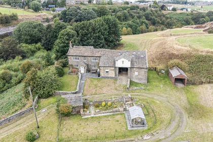
- Price
- Offers Over£695,000
- Size
- 9.2 acres
Added on 07/09/2026Smallholding
- Price
- Guide Price£625,000
- Size
- 42 acres
Ellershaw Farm, Halton Gill, Skipton, BD23, Halton Gill, North Yorkshire BD23 England
Added on 29/01/2026House with Land