Tunbridge Lane, Bramshott, Liphook, Hampshire, GU30
- Land size
- 10 acres
- Bedrooms
- 6
- Bathrooms
- 4
Key Features
- 3,419 square feet formal accommodation
- 1,117 square feet of lower ground floor storage/utility space
- 1,679 square feet of garage/outbuildings
- 6,215 square feet overall
- Formal gardens
- Wide terraces
- Riverside meadows
- Paddocks
- Stables
- Dressage/Sand school (formerly a tennis court)
Description
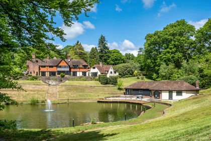
Nestled within approximately ten acres and set amidst the gentle Hampshire countryside, The Old Mill is an exceptional country home of rare character and history enjoying an idyllic and highly secluded setting whilst remaining conveniently accessible to the nearby villages of Bramshott, Liphook and Headley.
This beautifully converted former watermill, occupies a stunning position overlooking the River Wey and a spring fed lake with far-reaching views across its own land enjoying a tranquil wildlife friendly habitat rarely found.
The Old Mill presents a once-in-a-generation opportunity to acquire a landmark home and continue it’s rich heritage.
An electric gate opens to reveal a single track drive way meandering alongside the river, following the old waggoners route, to open up into a wide parking area leading to an integral double garage. The approach is such a gentle rural introduction where ducks, dragonflies and the occasional Kingfisher can be found before the magnificence of the Old Mill house is revealed, arranged over four floors this handsome home should feel imposing but the use of original cream Bargate Stone mean it feels warm and welcoming.
(Pedestrian access from Tunbridge Lane can also be found via a bridge over the river and further parking and garaging can be found via a separate access point alongside the stables and outbuildings.)
The river and lake gently caress the house to one side, with the formal gardens and sun terrace, the sand school and paddocks falling to the other, enjoying complete privacy with fields and woodland beyond.
As custodian of this truly special home you will continue it's almost 300 year history; from a working water corn mill to the modern accommodation enjoyed today having been comprehensively and sympathetically refurbished and upgraded by the current owners. The original mill stone can still be seen at Holycombe Steam Museum, just 3 miles away; the fixings for the original mill wheel can be seen within the wine cellar
Ground floor accommodation: Entrance hall – WC – Office - Triple aspect drawing room - Triple aspect kitchen/family/dining room - Two study/offices
First floor accommodation: Master bedroom with dressing room and en suite bathroom - Bedroom 2 with en suite shower room - Bedroom 3 - WC
Second floor accommodation: Three bedrooms - Two shower rooms
Lower ground floor accommodation: Boot room - Tack room - Utility room – Workshop - Wine cellar - Double garage
Outbuildings: Garage with two attached stores - Double car port with attached two bay stable block - three bay stable block plus tack room - Tractor store
The accommodation is incredibly generous and is immaculately presented throughout.
The large central hallway linking all the main reception rooms with stairs to both upper and lower levels.
Formal entertaining can be enjoyed in the triple aspect drawing room which features an ornate fireplace housing a wood burning stove and has access directly onto the sun terrace. Most day to day family life however will be centred around the large kitchen/dining/family room which offers panoramic views over the formal gardens and down to the lake and river. A central wood burning stove means this space can be throughout the year, with a large roof lanterns providing an abundance of natural light.
Two further reception rooms provide great versatility; both currently being used as home offices.
Bedroom accommodation is arranged over the top two floors, with built in wardrobes and stunning elevated garden views being enjoyed from all of them making them ideal for guests as well as family. The principle suite is dual aspect with dressing room and en suite bathroom. Two further first floor double bedrooms share a shower room plus an additional WC. The three double bedrooms on the 2nd floor benefiting from the use of two modern shower rooms.
The lower ground floor is the unseen working part of the house with various storage, workshop and utility area alongside the wine cellar.
Viewing highly recommended to appreciate all the nuances, space and charming accommodation available.
Distance to
• The A3 - 1.1 miles • Liphook train station - 2 miles • Haslemere train station - 5.5 miles
• Heathrow - 40 miles • Gatwick - 50 miles
• Market town of Petersfield - 11 miles • Georgian town of Farnham - 11 miles
• The South Coast - 30 miles
Tenure: Freehold
EPC Rating: F
Council Tax Band: (Correct at time of publication and is subject to change following a council revaluation after a sale)
Services: The property has mains water, electricity, oil fired central heating to radiators and 'private drainage connected to the main sewer.
Broadband and Mobile services: Visit checker.ofcom.org.uk
LOCATION: Tunbridge Lane is a rural country road, home to both large estates and more modest character cottages closer to the centre of this historic location.
Bramshott is a delightful rural village, with origins as a hamlet dating to the early 13th century. At the heart of the village is St Mary’s church (1220) which has an open churchyard extending to approximately 5 acres and includes over 300 Canadian WW1 war graves. The village radiates from this point with many character properties interspersed with more modern development. The area is surrounded by much woodland (Bramshott and Ludshott commons) which were formerly part of the Royal Forest of Woolmer, with the River Wey gently meandering through much of the village.
Facilities are available in Liphook and Haslemere which are around 2-3 miles away offering a wide range of independent shops, cafes, restaurants and pubs in addition to supermarket's (Sainsburys, Tesco's, Waitrose and Marks and Spencer’s food hall). They offer railway stations with services into London in less than an hour. The A3 close by offers excellent commuter links; Gatwick, Heathrow and Southampton airports are also all within an hour.
Golf and Leisure facilities are available close by at Griggs Green. Further sporting facilities include racing at Goodwood and Fontwell, polo at Cowdray Park and sailing on Frensham Ponds and off the south coast at Chichester Harbour. The centre of Guildford is 15 miles away, with an excellent range of leisure, sports, entertainment and dining facilities as well as Guildford Cathedral. An alternative would be Farnham (an old English Georgian market town with narrow cobbled streets and attractive architecture) boasting many shops, cafés and restaurants, a 12th century castle and parish church. The town plays host to monthly and seasonal markets and the centrally located Farnham Maltings Arts Centre offers theatre, film and crafts events. New to the town is Brightwells Yard complex bringing a new shopping centre with a six screen cinema, restaurants, town square and public gardens.
For families, the property is well-situated with excellent state and private schools nearby, including Liphook Infants and Juniors, Woolmer Hill and Bohunt Secondary Schools as well as several pre-school/nurserys.
There is an exceptional choice of schools in the area, including St Edmund’s and Amesbury at Hindhead, as well as St Ives in Haslemere, Brookham and Highfield in Liphook and Frensham Heights in Frensham. Other schools include Charterhouse at Godalming, Barrow Hills and King Edward’s at Witley, and Bedales and Cranleigh School slightly further afield.
Map Location
Property details
- Tenure
- Freehold
- Council Tax Band
- H
- Date Posted
- 2026-06-16
Market Value Analysis
Compared with 195 Homes with Land listings in South East England (10+ acres).
Energy Performance Certificate
Energy Efficiency Rating
Based on UK Energy Performance Certificate standards (EU Directive 2002/91/EC)
Running costs are one side. Planning activity, flood history and ground risks for this location are in the full report.
Utilities & Restrictions
Utilities
- Electricity
- Ask Agent
- Water
- Ask Agent
- Heating
- Ask Agent
- Broadband
- Ask Agent
- Sewerage
- Ask Agent
Rights & Restrictions
- Public Rights of Way
- Ask Agent
- Private Rights of Way
- Ask Agent
- Listed Property
- Ask Agent
- Restrictions
- Ask Agent
Listed status, conservation areas and planning constraints for this location are in the full report.
Property Features
- Accessibility
- Ask Agent
- Parking
- Parking Available
- Garden
- Garden
Beyond the particulars: planning activity, flood history, heritage and ground risks, checked for this exact spot.
Connectivity
Broadband
Fastest speed available at this postcode
1.8 Gbps
Gigabit full fibre · available to 94% of premises
Suitable for
- 4K streaming on every screen
- Full-time home working
- Online gaming & big downloads
Mobile signal
Outdoor predictions; indoor signal depends on building materials.
Ofcom Connected Nations postcode-level predictions. Speeds and signal are modelled, not measured, and vary between addresses and providers.
Signal is the easy part. Planning activity, flood history and protected designations here are in the full report.
Nearest Schools
Primary
- Liphook Infant School0.9 milesOfsted report card · May 2026
- Ages
- 4 to 7
- Pupils
- 267
- Type
- Community school
- Liphook Church of England Controlled Junior School0.9 milesOfsted report card · Jan 2026
- Ages
- 7 to 11
- Pupils
- 359
- Type
- Voluntary controlled school
- Faith
- Church of England
- The Holme Church of England Primary School2.3 milesNo Ofsted rating
- Ages
- 4 to 11
- Pupils
- 179
- Type
- Academy sponsor led
- Faith
- Church of England
- Grayshott Church of England Controlled Primary School2.4 milesOfsted report card · Apr 2026
- Ages
- 4 to 11
- Pupils
- 214
- Type
- Voluntary controlled school
- Faith
- Church of England
- Woodlea Primary School2.4 milesOfsted: Inadequate
- Ages
- 4 to 11
- Pupils
- 184
- Type
- Academy sponsor led
Secondary
- Bohunt School0.9 milesOfsted: Good
- Ages
- 11 to 18
- Pupils
- 2,012
- Type
- Academy converter
- Oakmoor School2.4 milesOfsted report card · Jan 2026
- Ages
- 11 to 16
- Pupils
- 912
- Type
- Academy sponsor led
- Woolmer Hill School2.5 milesNo Ofsted rating
- Ages
- 11 to 16
- Pupils
- 892
- Type
- Academy converter
- Weydon School7.6 milesOfsted: Good
- Ages
- 11 to 16
- Pupils
- 1,666
- Type
- Academy converter
- Midhurst Rother College7.7 milesOfsted: Outstanding
- Ages
- 11 to 18
- Pupils
- 1,144
- Type
- Academy sponsor led
Distances are straight-line from the advertised location. Source: the national school registers (DfE, Welsh Government, Scottish Government) and Ofsted.
Schools are just the start: sold prices nearby, planning activity and any flood history are in the full report.
Amenities
Supermarket
GP surgery
Pharmacy
Hospital
Green space
Straight-line distances from the advertised location. Sources: NHS records, Geolytix supermarket locations, OS Open Greenspace and the national trails registers.
The area stacks up? Now check the location itself: planning nearby, protected designations and past flooding.
Getting Around
Nearest station
Nearest bus stop
Typical drive times
Straight-line distances from the advertised location; drive times are typical free-flow times over OpenStreetMap road data, so allow more at peak. Public transport locations from DfT NaPTAN.
Easy to reach matters. So do planning activity, flood history and ground risks: all in the full report.
Flood Risk
From Environment Agency flood map open data, checked around the advertised map pin and allowing for the listed acreage where known. This summary comes from LandSale, the advertising platform, not from the listing agent, and is not part of the agent's particulars. Risk can vary across a single holding, so verify anything critical through your own searches before committing.
Rivers and the sea
Mapped within the area searched, not at the advertised map pin itself.
Surface water
Mapped within the area searched, not at the advertised map pin itself.
These bandings are the summary. Where this location sits on the flood maps, plus planning activity, heritage and ground risks, is in the full report.
Important notice: Information, maps and tags on this page are drawn from the advertising agent's marketing materials or generated automatically. LandSale has not verified them. Relying on these details is at your own risk, always carry out independent checks before committing to a purchase.
LandSale full disclaimer
Marketing information only - not formal particulars. The details on this website are provided for general guidance and do not constitute an offer or contract. Neither LandSale nor the advertising estate/land agent accepts responsibility for any inaccuracy.
1. Source of information
- Listing content: Core description, asking price, tenure, measurements, photographs and planning history originate from the marketing materials of the advertising estate or land agent. LandSale does not author this content and cannot guarantee its accuracy.
- Automated tags & categorisation: Property type, land-use class, acreage bands and similar labels may be applied by machine-learning models. They are intended as a helpful guide only and may not reflect the property's legal status or permitted use.
- Third-party & enriched data layers: Maps, boundary outlines, planning designations, soil reports, broadband coverage and other environmental or location-based insights are licensed from external suppliers. Such data are supplied “as is", may be incomplete or out of date and are subject to change without notice.
2. Verification required
Prospective purchasers must verify critical matters, including but not limited to planning permission, title boundaries, public rights of way, environmental constraints, acreage, services, access and VAT status, through their own inspections, specialist surveys, legal advisers and the selling agent before relying on the information or entering into any contract.
3. No warranty or liability
LandSale gives no warranty, express or implied, as to the accuracy, completeness or fitness for any particular purpose of the information displayed. LandSale shall not be liable for any loss, damage, cost or expense arising directly or indirectly from any use of or reliance on such information, save where liability may not be excluded by law.
4. Updates & feedback
If you believe any detail on this listing is inaccurate, please let us know. We will investigate and, where appropriate, update the listing or notify the agent.
© LandSale | Version 1.3 - August 2026
Listing agent
Seymours Prestige Homes, Covering London To The South East
London
Similar properties for sale
- Price
- Offers Over£3,250,000
- Size
- 10.4 acres
Durford Wood, Petersfield, GU31, Rogate, West Sussex GU31 England
Added on 29/01/2026Country Home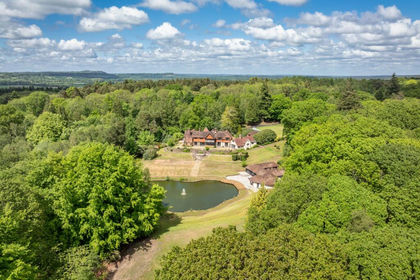
- Price
- £3,250,000
- Size
- 10.4 acres
Durford Wood, Petersfield, West Sussex, Rogate, West Sussex GU31 England
Added on 17/06/2026Country Estate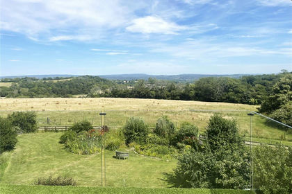
- Price
- Guide Price£3,250,000
- Size
- 10 acres
Priors Dean, Petersfield, Hampshire, GU32, Colemore and Priors Dean, Hampshire GU32 England
Added on 15/08/2026House with Land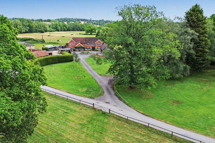
- Price
- Guide Price£2,250,000
- Size
- 43 acres
Milford Road, Elstead, Godalming, Surrey, GU8, Peper Harow, Surrey GU8 England
Added on 13/06/2026Country Home
- Price
- Offers in Excess of£3,500,000
- Size
- 8 acres
Eastbury Lane, Compton, Surrey, GU3 1, Compton, Surrey GU3 England
Added on 29/01/2026Estate
- Price
- Guide Price£2,750,000
- Size
- 21 acres
Oxenbourne Lane, East Meon, Petersfield, Hampshire, GU32, East Meon, Hampshire GU32 England
Added on 15/09/2026House with Land
- Price
- Offers in Excess of£3,500,000
- Size
- 27 acres
Added on 29/01/2026House with Land
- Price
- Guide Price£2,600,000
- Size
- 5 acres
Dye House Lane, Duncton, Petworth, West Sussex, GU28, Duncton, West Sussex GU28 England
Added on 28/06/2026Country Home
- Price
- Offers in Excess of£2,750,000
- Size
- 9.95 acres
Roundstreet Common, Wisborough Green, RH14, Loxwood, West Sussex RH14 England
Added on 14/05/2026Country Home
- Price
- Guide Price£2,825,000
- Size
- 21 acres
Loxwood Road, Rudgwick, Horsham, West Sussex, RH12, Rudgwick, West Sussex RH12 England
Added on 01/09/2026Country Estate