Nr Falmouth, South Cornwall
- Land size
- 33.84 acres
- Bedrooms
- 6
- Bathrooms
- 3
Key Features
- Private Grade II listed manor house close to Helford Passage and Port Navas
- Six separate cottages / ancillary accommodation
- Derelict detached bungalow with lapsed consent to replace with a four bedroom home
- Mature, well established gardens, including fruit and vegetable areas, terraces and courtyard
- A range of outbuildings and storage buildings
- Lot 1: about 33.84 acres
- Lot 2: about 86.24 acres
- Lot 3: a 100ft glasshouse, offering development potential (subject to consents) on about 0.43 acres
- Council Tax Bands - see main description
- EPCs - see main description
Description
SETTING THE SCENE
Trenarth Manor lies south of Falmouth near the Helford River in south Cornwall.
The North Helford area stretches along the north bank of the beautiful Helford River and separates the Helford River from Falmouth. The area is knitted together by the charming villages of Mawnan Smith, Constantine, Port Navas and Helford Passage, together with wooded creeks, rolling farmland, not forgetting the wonderful gardens of Trebah and Glendurgan. Nearby Port Navas has its own yacht club with restaurant and once home to the Duchy Oyster Farm, a historic stone quay sits opposite the house and plays host to the annual Port Navas Regatta.
The Helford River itself has deep-water moorings and an active sailing club. There are two local waterside pubs; the thatched Shipwrights pub on the south side of the river and the Ferry Boat Inn on the north side. Much of the countryside surrounding the Helford Estuary is owned by the National Trust and is designated as an Area of Outstanding Natural Beauty, flush with an endless number of beautiful creek-side and coastal walks.
The nearby village of Mawnan Smith has excellent day-to-day amenities include public house, doctors surgery, garage, convenience stores, village hall and a primary school.
Constantine has also has its own primary school and provides a good range of shops and amenities, including the renowned Constantine Stores wine merchants, whilst the port and university town of Falmouth is close at hand with its sandy beaches and yacht marinas. About an hour's drive, Newquay airport has regular flights to London while in Truro - approximately half an hour's drive, there are independent prep' and secondary schools and a mainline station with overnight sleeper service to London Paddington.
HISTORY
For over 800 years, Trenarth has been home to those living, working, and farming on its fertile, south-facing slopes. The site was likely chosen for its proximity to the river for communication, abundant woodland for fuel and grazing, streams bordering the fields, and readily available stone for building.
The house itself is a charming patchwork of styles spanning six centuries, reflecting the changing fortunes of its owners. Dating back to at least 1260, its history includes the original Trenarth family, the Trefusis family by marriage in 1658, and the Nicholas family, who held the property from the early 18th century until 1842. Several date stones, such as a 1658 plaque featuring the Trenarth and Trefusis arms with the motto God Giveth Strength, provide glimpses into its past. The early history is described in one chapter of Charles Henderson's book published in 1937, "Constantine in Cornwall" chapter XIV
The granite-built house features 16th-century cellars and a former kitchen, an 18th-century Georgian front added by the prosperous Nicholas family, and later 19th-century incorporations of outbuildings. A modern garden room, added in 2002, complements this eclectic "liquorice all sorts" house, which sits at 300 feet above sea level, offering uninterrupted views of its fields, woods, and streams leading to Port Navas creek and the Helford River.
THE TOUR
A fine Grade II listed country estate with a rich history dating back to the 13th century, Trenarth is set in a serene and idyllic location above the Helford River. Approached via a long drive, the estate spans almost 34 acres of rolling pasture and woodland, offering uninterrupted views across its land. Completely private and wonderfully peaceful, it is a true rarity, with the main house, cottages, outbuildings, gardens, and extensive acreage providing endless potential and exceptional lifestyle appeal.
Arranged around an enchanting Elizabethan courtyard, the main house unfolds across 10,847 sqft of beautifully proportioned and character-rich interiors that seamlessly blend centuries of architectural evolution. Originally constructed as a granite farmhouse in the 16th century, the house was later improved with a south-west facing Georgian façade, while successive additions in the 18th and 19th centuries incorporated further outbuildings, creating a harmonious fusion of vernacular and classical styles. Inside, the home abounds with historic features, including grand sash windows, and a elegant period staircase. These timeless elements offer abundant potential for thoughtful re-imagination while preserving the house's storied heritage.
The ground floor offers a series of generous living and entertaining spaces, including an impressive entrance hall, family kitchen, a 17th century refectory with stone mullioned windows, a granite inglenook fireplace and original slate floor, drawing room, TV room, study dining room, and garden room. Upstairs, a spacious landing leads to a grand principal suite, two further bedrooms, and ensuite bathrooms, all with high ceilings and captivating garden vistas. A secondary staircase leads up to the south-east facing 'granny wing' where there is a further bedroom with en suite bathroom and study. The 'East Cottage', which has its own external access, is currently arranged as a self-contained apartment but could easily be restored to the main house to provide two additional bedrooms.
The property also includes useful garaging, utility spaces, and cellars below with the ground source heat pump, ample storage and versatile potential for a variety of uses.
STEP OUTSIDE
The estate is exceptionally private, set within its own exquisitely manicured gardens and grounds with no outside intrusion, offering unmatched peace and tranquility.
Historically focused on practical horticulture, the farm's 18th-century garden Listed walls once enclosed vegetable and fruit gardens, with three orchards noted on a 19th-century estate map. Early landscaping features include a lone Monterey pine and remnants of a 19th-century avenue. By the 1950s, the estate supported a horticultural business, producing cut flowers like anemones and daffodils, with traces of greenhouses still evident in the restored potting shed. In the 1960s, the gardens were further transformed with a large orchard, yew-hedged garden 'rooms,' terrace walls, and shelter belts. Over the past 28 years, the gardens have expanded to cover 3-4 acres, retaining their strong framework of hedges and walls.
Today, the gardens are wonderfully diverse, featuring a 16th-century sheltered courtyard, formal walled gardens, an orchard, and a vegetable patch. The mild climate enables ambitious planting, ensuring year-round colour and variety. Recent additions include a gravel garden with granite and palms, a bog garden named "Paget's Puddle," a beech walk, parkland, children's play areas, and whimsical seating with surprising touches throughout. Commanding views of the surrounding countryside can be enjoyed from nearly every angle. They have been regularly open for many years for the NGS, Cornwall Wildlife Trust, Cornwall Hospices, and the Cornwall Heritage Trust. The creation of the gardens in such a favoured area and location has been a huge pleasure and the result is well described in the entry in "Secret Gardens of Cornwall", by Tim Hubbard, published in 2023.
COTTAGES AND OUTBUILDINGS
To the rear of the house, a collection of charming, converted barns, consisting of five letting cottages, are neatly arranged around a courtyard and feature garages along with a spacious workshop.
Just a short distance away, up a separate drive, sits a disused detached bungalow in an idyllic setting, with recently lapsed planning permission granted to rebuild it as a substantial four-bedroom family home with stunning views across an area of ANOB.
LOT 2 Guide Price £850,000
Further land and woodland is available by separate negotiation and extends to 86.24 acres (34.90 ha)
LOT 3 Guide Price £150,000
At the top of the drive there is a 100ft glass house, in need of renovation or subject to the necessary consents provides an opportunity for development into a sperate dwelling. The building is within about 0.43 acres (0.17 ha)
REDEVELOPMENT POTENTIAL
Just a short distance away, up a separate drive, sits a disused detached bungalow in an idyllic setting, with recently lapsed planning permission (PA22/07263) granted to rebuild it as a substantial four-bedroom family home with stunning views across an area of ANOB. We are aware that there is asbestos in this building
COUNCIL TAX BANDS
The Manor G, The Piggery B, The Lodge C, The Stable Wing C, Old Farm Office A, East Cottage A and Range Cottage C
EPC RATINGS
The Manor F, The Piggery C, The Lodge E, The Stable Wing E, Old Farm Office E, East Cottage E and Range Cottage E
LISTING DETAILS
Grade II listed (List Entry Number:1311213 & 1142136).
RIGHTS OF WAY
Please see site plan showing the location of the footpath (blue dotted line) which are located some distance from the property.
There is an agricultural right of way across the southern part of lot 3 to the neighbouring land.
SERVICES
Mains water and electricity. Private drainage, improvements made in 2024. The vendors are not able to confirm that the septic tank is compliant with current legislation. Prospective purchasers are advised to make their own investigations. Ground source heat pump for radiators and hot water in the main house. Night storage heating in additional properties. Oil fired four oven AGA. FTTP (Fibre To The Premises) broadband.
DISTANCES (all distances approximate)
Port Navas 2 miles, Mawnan Smith 2 miles, Constantine 2 miles, Gweek 4 miles, Falmouth 5 miles, Helston 8 miles, Truro 11 miles, Newquay Airport 30 miles
WHAT3WORDS LOCATION
///grape.ripe.scrambles
Map Location
Property details
- Tenure
- Freehold
- Council Tax Band
- Ask Agent
- Date Posted
- 2026-06-13
Market Value Analysis
Compared with 71 Homes with Land listings in South West England (25+ acres).
Utilities & Restrictions
Utilities
- Electricity
- Ask Agent
- Water
- Ask Agent
- Heating
- Ask Agent
- Broadband
- Ask Agent
- Sewerage
- Ask Agent
Rights & Restrictions
- Public Rights of Way
- Ask Agent
- Private Rights of Way
- Ask Agent
- Listed Property
- Ask Agent
- Restrictions
- Ask Agent
Listed status, conservation areas and planning constraints for this location are in the full report.
Property Features
- Accessibility
- Ask Agent
- Parking
- Parking Available
- Garden
- Garden
Beyond the particulars: planning activity, flood history, heritage and ground risks, checked for this exact spot.
Connectivity
Broadband
Fastest speed available at this postcode
60 Mbps
Superfast · available to 47% of premises
Suitable for
- HD streaming
- Video calls
- Web & social
Fixed wireless access may also be an option here.
Mobile signal
Outdoor predictions; indoor signal depends on building materials.
Ofcom Connected Nations postcode-level predictions. Speeds and signal are modelled, not measured, and vary between addresses and providers.
Signal is the easy part. Planning activity, flood history and protected designations here are in the full report.
Nearest Schools
Primary
- Mawnan CofE VA Primary School1.4 milesOfsted: Outstanding *
- Ages
- 4 to 11
- Pupils
- 144
- Type
- Voluntary aided school
- Faith
- Church of England
- Constantine Primary School1.8 milesOfsted: Good
- Ages
- 4 to 11
- Pupils
- 155
- Type
- Academy converter
- Manaccan Primary School2.4 milesOfsted: Requires improvement
- Ages
- 3 to 11
- Pupils
- 32
- Type
- Academy converter
- St Francis CofE Primary School3.1 milesOfsted report card · May 2026
- Ages
- 4 to 11
- Pupils
- 396
- Type
- Academy converter
- Faith
- Church of England
- St Mary's Catholic Primary School, Falmouth3.2 milesOfsted: Good *
- Ages
- 4 to 11
- Pupils
- 187
- Type
- Academy converter
- Faith
- Roman Catholic
Secondary
- Falmouth School3.5 milesOfsted: Good *
- Ages
- 11 to 18
- Pupils
- 923
- Type
- Academy converter
- Penryn College3.6 milesNo Ofsted rating
- Ages
- 11 to 16
- Pupils
- 1,140
- Type
- Academy converter
- Helston Community College6 milesOfsted: Good
- Ages
- 0 to 18
- Pupils
- 1,297
- Type
- Academy converter
- Mullion School7.7 milesOfsted: Good
- Ages
- 11 to 16
- Pupils
- 548
- Type
- Academy converter
- Redruth School9.2 milesNo Ofsted rating
- Ages
- 11 to 16
- Pupils
- 1,433
- Type
- Foundation school
* Latest graded judgement covers quality of education only; no overall grade was issued under the 2024-25 inspection framework.
Distances are straight-line from the advertised location. Source: the national school registers (DfE, Welsh Government, Scottish Government) and Ofsted.
Schools are just the start: sold prices nearby, planning activity and any flood history are in the full report.
Amenities
Supermarket
GP surgery
Pharmacy
Hospital
Walking trail
Straight-line distances from the advertised location. Sources: NHS records, Geolytix supermarket locations, OS Open Greenspace and the national trails registers.
The area stacks up? Now check the location itself: planning nearby, protected designations and past flooding.
Getting Around
Nearest station
Nearest bus stop
Typical drive times
Straight-line distances from the advertised location; drive times are typical free-flow times over OpenStreetMap road data, so allow more at peak. Public transport locations from DfT NaPTAN.
Easy to reach matters. So do planning activity, flood history and ground risks: all in the full report.
Flood Risk
From Environment Agency flood map open data, checked around the advertised map pin and allowing for the listed acreage where known. This summary comes from LandSale, the advertising platform, not from the listing agent, and is not part of the agent's particulars. Risk can vary across a single holding, so verify anything critical through your own searches before committing.
Rivers and the sea
Surface water
The detail behind these bandings
The full report pinpoints where this location sits on the flood maps, and runs the deeper checks that usually only surface after an offer.
- Exact flood zones & annual chances (included in the full report)
- Any recorded past flooding (included in the full report)
- Planning activity nearby (included in the full report)
- Heritage & conservation (included in the full report)
- Protected nature designations (included in the full report)
- Ground risks (included in the full report)
- Sold prices nearby (included in the full report)
£14.99 · one-off purchase
By LandSale, the platform. Not provided by the listing agent. Ready in about a minute.
Important notice: Information, maps and tags on this page are drawn from the advertising agent's marketing materials or generated automatically. LandSale has not verified them. Relying on these details is at your own risk, always carry out independent checks before committing to a purchase.
LandSale full disclaimer
Marketing information only - not formal particulars. The details on this website are provided for general guidance and do not constitute an offer or contract. Neither LandSale nor the advertising estate/land agent accepts responsibility for any inaccuracy.
1. Source of information
- Listing content: Core description, asking price, tenure, measurements, photographs and planning history originate from the marketing materials of the advertising estate or land agent. LandSale does not author this content and cannot guarantee its accuracy.
- Automated tags & categorisation: Property type, land-use class, acreage bands and similar labels may be applied by machine-learning models. They are intended as a helpful guide only and may not reflect the property's legal status or permitted use.
- Third-party & enriched data layers: Maps, boundary outlines, planning designations, soil reports, broadband coverage and other environmental or location-based insights are licensed from external suppliers. Such data are supplied “as is", may be incomplete or out of date and are subject to change without notice.
2. Verification required
Prospective purchasers must verify critical matters, including but not limited to planning permission, title boundaries, public rights of way, environmental constraints, acreage, services, access and VAT status, through their own inspections, specialist surveys, legal advisers and the selling agent before relying on the information or entering into any contract.
3. No warranty or liability
LandSale gives no warranty, express or implied, as to the accuracy, completeness or fitness for any particular purpose of the information displayed. LandSale shall not be liable for any loss, damage, cost or expense arising directly or indirectly from any use of or reliance on such information, save where liability may not be excluded by law.
4. Updates & feedback
If you believe any detail on this listing is inaccurate, please let us know. We will investigate and, where appropriate, update the listing or notify the agent.
© LandSale | Version 1.3 - August 2026
Listing agent
Jonathan Cunliffe, Cornwall
Cornwall
Similar properties for sale
- Price
- Guide Price£2,850,000
- Size
- 1.5 acres
Budock Vean, near Falmouth - overlooking Port Navas Creek, Cornwall, Mawnan, Cornwall TR11 England
Added on 05/08/2026House with Land
- Price
- £2,500,000
- Size
- 1.5 acres
Added on 29/07/2026Country Home
- Price
- Guide Price£2,000,000
- Size
- 1 acres
Added on 14/06/2026House with Land
- Price
- £3,400,000
- Size
- 8 acres
Private Country Estate, Budock Water, Falmouth, Cornwall, Budock, Cornwall TR11 England
Added on 17/05/2026Country Estate
- Price
- £1,995,000
- Size
- 18 acres
Roskrow, between Falmouth and Truro, Cornwall, Ponsanooth, Cornwall TR10 England
Added on 11/04/2026House with Land
- Price
- Guide Price£1,650,000
- Size
- 1.7 acres
Rose Hill Cottage, Mylor, South Cornwall, Mylor, Cornwall TR11 England
Added on 08/08/2026House with Land
- Price
- Guide Price£1,650,000
- Size
- 1.7 acres
Added on 14/03/2026Cottage
- Price
- Guide Price£3,500,000
- Size
- 1.65 acres
St. Mawes waterfront, South Cornwall, St. Just-in-Roseland, Cornwall TR2 England
Added on 20/07/2026Waterfront property
- Price
- Guide Price£1,500,000
- Size
- 11.1 acres
Added on 29/01/2026Smallholding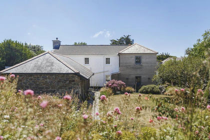 Added on 09/07/2026Farmhouse