Nr Helford, South Cornwall
- Land size
- 1 acres
- Bedrooms
- 5
- Bathrooms
- 4
Key Features
- Historic manor house
- 5 double bedrooms
- 37ft kitchen with AGA
- 30ft Sitting room
- Panelled study/library
- South-facing gardens of about 1 acre
- Generous range of attractive outbuildings
- Freehold with Council Tax Band G
- Listed grade II
- 5099 sqft
Description
SETTING THE SCENE
Old Church Road is without doubt one of the most desirable residential addresses in south Cornwall, and leads to the pretty Mawnan Church, overlooking the entrance to the Helford River..
The area around Trerose Manor is one of Outstanding Natural Beauty with many beautiful coastal walks. A footpath close to the house leads down to Prisk Beach and another from the church down to the beaches on the north shore of the Helford River and westwards towards Durgan. There are deep-water moorings available in the river with Helford River Sailing Club on the south bank of the estuary.
The mild climate here has made it home to some of the country's most celebrated gardens, offering a wealth of rare and exotic plants. Indeed, Mawnan Smith is sometimes referred to as "the gardens parish of Cornwall", being home to both Trebah and Glendurgan.
The busy port and university town of Falmouth is nearby, with a rail connection to Truro, which is on the main London-Paddington to Penzance line with an overnight 'sleeper' service. Approximately one hour's drive from Trerose is Newquay regional airport and in Truro, approximately half an hour's drive, independent prep' and secondary schools.
HISTORY
Cornwall's history has largely been determined by its geographical location at the extreme westerly tip of England, with its rugged coastline surrounded on three sides by the sea. The history of Trerose, likewise, could be said to derive from its strategic position at the mouth of the Helford River, used to advantage in times gone by, by seafarers, smugglers and pirates with local knowledge of the estuary.
In Cornish, Trerose means 'The house on the headland'. During the 16th Century Trerose Manor was the property of the Killigrew family, who played a significant role in shaping Falmouth's maritime history and despite holding high office, were also notorious pirates. In 1635, Sir Robert Killigrew (who was Deputy Lieutenant - and later MP for Cornwall) sold Trerose to Sir Nicholas Slanning, Governor of Pendennis Castle, a staunch royalist who was killed at the Battle of Bristol.
In 1675 Trerose was sold to the Rogers family and for the next three hundred years was the property of a number of local families. Perhaps best underlining how special it is, Trerose Manor has only changed hands once since 1979.
THE TOUR
A pillared portico leads into a reception hall with a slate-flagged floor and an illuminated well. Beyond there is an impressive 37ft kitchen/family room, which is the heart of the house. It has a four oven oil-fired AGA at one end, and a wood-burner in a stone fireplace at the other; the dining area can comfortably seat twelve people. Three pairs of French windows open onto the south-facing slate terrace, which runs the full length of the building. Behind the kitchen is a walk-in larder and also a spacious additional kitchen/utility room with access into the hall.
A beautifully proportioned dual-aspect sitting room with floor to ceiling sash windows and an open fireplace leads from the kitchen/family room. To the right of the fireplace is a secret door to a workshop/office with further access to the rear courtyard. In the wing is a handsome panelled library with parquet floor, wood-burner and sash windows.
There are two separate staircases to the first floor which contains five bedrooms (three with en suite bathrooms) and a shower room on the half landing. From the first floor landing, there is a further staircase up to an attic, which is floored and runs the whole length of the building providing extensive storage.
THE GREAT OUTDOORS
The sheltered garden is a perfect blend of a plantsman's paradise and a family garden. The large level lawn in front of the house is ideal for energetic family games and the carefully planned herbaceous borders surrounding the lawn provide a wealth of year-round colour.
In the lower garden there is a wide selection of interesting trees and shrubs, many of which are particularly suited to the mild Cornish climate. Of particular interest is a tree dahlia which was brought back from the Himalayas by a previous owner.
Beside the parking/turning area is a small former stable block, an attractive clock tower, and a garage/garden tool store. At the bottom of the drive is a boat-store and behind the main building a wood store with convenient access via the workshop to the open fire in the drawing room. There are two greenhouses - one by the drive and one in the garden; there is also a potting shed.
Far and away the greatest joy of the garden at Trerose is the immense sense of privacy, peace and tranquillity. Trerose is a beautiful Cornish house, but above all it is a home, imbued with tangible warmth and happiness. The garden in which it sits reflects and enhances this enduring spirit.
OWNERS' COMMENT
"We fell in love with Trerose Manor the moment we walked in. Its Georgian architecture, timeless proportions, and sense of heritage spoke to us, but it was the way the house feels protected and sheltered from the elements that sealed the deal. Set back in mature gardens, the building has a solidity and calm that belies its proximity to the sea.
The location is magical: being within walking distance of the Cornish coast and South West path, yet tucked away gives us the best of both worlds. We enjoy Atlantic views on calm days, while the manor's orientation and landscaping buffer us all year round.
The garden is truly a dream, mature trees, flower borders, sheltered terraces, hidden pathways, it feels like a private world in itself. Sitting in the greenhouse on an autumn evening, with the sea air just audible in the distance, it's hard to believe it's so close to the bustle of coastal life and Falmouth.
For us, Trerose Manor was not just a purchase, it's a sanctuary. A strong, elegant Georgian home that gives the comfort of shelter, yet rewards you daily with its proximity to sea, sky, and garden wonder."
DISTANCES (all approximate)
Mawnan Smith 1 mile, Helford Passage 4 miles, Falmouth 5 miles, Truro 13 miles
SERVICES
Mains water and electricity. Private drainage. Oil-fired AGA and central heating system (2 boilers)
WHAT3WORDS LOCATION
///bonfires.join.rents
COUNCIL TAX BAND
G
Map Location
Property details
- Tenure
- Freehold
- Council Tax Band
- Ask Agent
- Date Posted
- 2026-06-14
Market Value Analysis
Compared with 1,731 Homes with Land listings in South West England (1+ acres).
Utilities & Restrictions
Utilities
- Electricity
- Ask Agent
- Water
- Ask Agent
- Heating
- Ask Agent
- Broadband
- Ask Agent
- Sewerage
- Ask Agent
Rights & Restrictions
- Public Rights of Way
- Ask Agent
- Private Rights of Way
- Ask Agent
- Listed Property
- Ask Agent
- Restrictions
- Ask Agent
Listed status, conservation areas and planning constraints for this location are in the full report.
Property Features
- Accessibility
- Ask Agent
- Parking
- Parking Available
- Garden
- Garden
Beyond the particulars: planning activity, flood history, heritage and ground risks, checked for this exact spot.
Connectivity
Broadband
Fastest speed available at this postcode
33 Mbps
Superfast · available to 50% of premises
Suitable for
- HD streaming
- Video calls
- Web & social
Fixed wireless access may also be an option here.
Mobile signal
Outdoor predictions; indoor signal depends on building materials.
Ofcom Connected Nations postcode-level predictions. Speeds and signal are modelled, not measured, and vary between addresses and providers.
Signal is the easy part. Planning activity, flood history and protected designations here are in the full report.
Nearest Schools
Primary
- Mawnan CofE VA Primary School0.7 milesOfsted: Outstanding *
- Ages
- 4 to 11
- Pupils
- 144
- Type
- Voluntary aided school
- Faith
- Church of England
- Manaccan Primary School2.2 milesOfsted: Requires improvement
- Ages
- 3 to 11
- Pupils
- 32
- Type
- Academy converter
- Marlborough School2.9 milesOfsted report card · Jun 2026
- Ages
- 4 to 11
- Pupils
- 212
- Type
- Community school
- St Francis CofE Primary School3 milesOfsted report card · May 2026
- Ages
- 4 to 11
- Pupils
- 396
- Type
- Academy converter
- Faith
- Church of England
- St Mary's Catholic Primary School, Falmouth3 milesOfsted: Good *
- Ages
- 4 to 11
- Pupils
- 187
- Type
- Academy converter
- Faith
- Roman Catholic
Secondary
- Falmouth School3.5 milesOfsted: Good *
- Ages
- 11 to 18
- Pupils
- 923
- Type
- Academy converter
- Penryn College4.2 milesNo Ofsted rating
- Ages
- 11 to 16
- Pupils
- 1,140
- Type
- Academy converter
- Helston Community College7.9 milesOfsted: Good
- Ages
- 0 to 18
- Pupils
- 1,297
- Type
- Academy converter
- Mullion School8.5 milesOfsted: Good
- Ages
- 11 to 16
- Pupils
- 548
- Type
- Academy converter
- Richard Lander School11 milesNo Ofsted rating
- Ages
- 11 to 16
- Pupils
- 1,561
- Type
- Community school
* Latest graded judgement covers quality of education only; no overall grade was issued under the 2024-25 inspection framework.
Distances are straight-line from the advertised location. Source: the national school registers (DfE, Welsh Government, Scottish Government) and Ofsted.
Schools are just the start: sold prices nearby, planning activity and any flood history are in the full report.
Amenities
Supermarket
GP surgery
Pharmacy
Hospital
Green space
Walking trail
Straight-line distances from the advertised location. Sources: NHS records, Geolytix supermarket locations, OS Open Greenspace and the national trails registers.
The area stacks up? Now check the location itself: planning nearby, protected designations and past flooding.
Getting Around
Nearest station
Nearest bus stop
Typical drive times
Straight-line distances from the advertised location; drive times are typical free-flow times over OpenStreetMap road data, so allow more at peak. Public transport locations from DfT NaPTAN.
Easy to reach matters. So do planning activity, flood history and ground risks: all in the full report.
Flood Risk
From Environment Agency flood map open data, checked around the advertised map pin and allowing for the listed acreage where known. This summary comes from LandSale, the advertising platform, not from the listing agent, and is not part of the agent's particulars. Risk can vary across a single holding, so verify anything critical through your own searches before committing.
Rivers and the sea
Surface water
The detail behind these bandings
The full report pinpoints where this location sits on the flood maps, and runs the deeper checks that usually only surface after an offer.
- Exact flood zones & annual chances (included in the full report)
- Any recorded past flooding (included in the full report)
- Planning activity nearby (included in the full report)
- Heritage & conservation (included in the full report)
- Protected nature designations (included in the full report)
- Ground risks (included in the full report)
- Sold prices nearby (included in the full report)
£14.99 · one-off purchase
By LandSale, the platform. Not provided by the listing agent. Ready in about a minute.
Important notice: Information, maps and tags on this page are drawn from the advertising agent's marketing materials or generated automatically. LandSale has not verified them. Relying on these details is at your own risk, always carry out independent checks before committing to a purchase.
LandSale full disclaimer
Marketing information only - not formal particulars. The details on this website are provided for general guidance and do not constitute an offer or contract. Neither LandSale nor the advertising estate/land agent accepts responsibility for any inaccuracy.
1. Source of information
- Listing content: Core description, asking price, tenure, measurements, photographs and planning history originate from the marketing materials of the advertising estate or land agent. LandSale does not author this content and cannot guarantee its accuracy.
- Automated tags & categorisation: Property type, land-use class, acreage bands and similar labels may be applied by machine-learning models. They are intended as a helpful guide only and may not reflect the property's legal status or permitted use.
- Third-party & enriched data layers: Maps, boundary outlines, planning designations, soil reports, broadband coverage and other environmental or location-based insights are licensed from external suppliers. Such data are supplied “as is", may be incomplete or out of date and are subject to change without notice.
2. Verification required
Prospective purchasers must verify critical matters, including but not limited to planning permission, title boundaries, public rights of way, environmental constraints, acreage, services, access and VAT status, through their own inspections, specialist surveys, legal advisers and the selling agent before relying on the information or entering into any contract.
3. No warranty or liability
LandSale gives no warranty, express or implied, as to the accuracy, completeness or fitness for any particular purpose of the information displayed. LandSale shall not be liable for any loss, damage, cost or expense arising directly or indirectly from any use of or reliance on such information, save where liability may not be excluded by law.
4. Updates & feedback
If you believe any detail on this listing is inaccurate, please let us know. We will investigate and, where appropriate, update the listing or notify the agent.
© LandSale | Version 1.3 - August 2026
Listing agent
Jonathan Cunliffe, Cornwall
Cornwall
Similar properties for sale
- Price
- Guide Price£2,500,000
- Size
- 33.84 acres
Nr Falmouth, South Cornwall, Constantine, Cornwall TR11 England
Added on 13/06/2026Country Estate
- Price
- £2,500,000
- Size
- 1.5 acres
Added on 29/07/2026Country Home
- Price
- Guide Price£1,650,000
- Size
- 1.7 acres
Rose Hill Cottage, Mylor, South Cornwall, Mylor, Cornwall TR11 England
Added on 08/08/2026House with Land
- Price
- Guide Price£1,650,000
- Size
- 1.7 acres
Added on 14/03/2026Cottage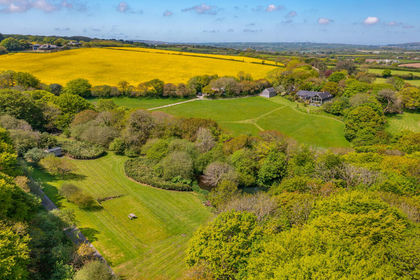
- Price
- £1,995,000
- Size
- 18 acres
Roskrow, between Falmouth and Truro, Cornwall, Ponsanooth, Cornwall TR10 England
Added on 11/04/2026House with Land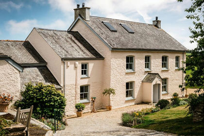
- Price
- Guide Price£1,595,000
- Size
- 1.75 acres
St Just in Roseland, South Cornwall, St. Just-in-Roseland, Cornwall TR2 England
Added on 29/01/2026Farmhouse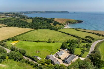
- Price
- Guide Price£2,250,000
- Size
- 2.37 acres
350 yards walk from The Hidden Hut and Porthcurnick Beach, Gerrans, Cornwall TR2 England
Added on 01/09/2026House with Land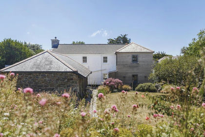 Added on 09/07/2026Farmhouse
- Price
- Guide Price£1,500,000
- Size
- 11.1 acres
Added on 29/01/2026Smallholding
- Price
- Guide Price£1,500,000
- Size
- 1 acres
Rosevine, Nr. Portscatho, Truro, South Cornwall, Gerrans, Cornwall TR2 England
Added on 31/07/2026House with Land