Lower Wat Ing, London Road, Norland HX6
- Land size
- 9 acres
- Bedrooms
- 5
- Bathrooms
- 3
Key Features
- IMPRESSIVE GRADE II LISTED DETACHED COUNTRY RESIDENCE
- HISTORIC PROPERTY RETAINING MANY ORIGINAL FEATURES
- THREE GENEROUS RECEPTION ROOMS
- BESPOKE BREAKFAST KITCHEN WITH ISLAND
- LARGE BOOT ROOM & CLOAKROOM
- FIVE BEDROOMS, BATHROOM & TWO EN-SUITES
- BEAUTIFUL GARDENS & VIEWS
- SUBSTANTIAL DETACHED BARN
- APPROXIMATELY 9 ACRES OF LAND
- DRIVEWAY & EXTENSIVE PARKING
Description
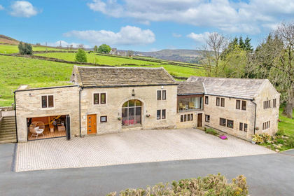
This impressive Grade II Listed country residence, dating from 1664, beautifully combines its rich heritage with a comprehensive program of recent improvements. Sympathetically enhanced throughout, the property retains an abundance of original character features, including timber doors, ornate stone fireplaces, mullioned windows, exposed beams and trusses, and stone flooring, while benefiting from a complete decorative overhaul, new plumbing, bespoke timber-framed windows, a stunning handcrafted kitchen, and extensive external works.
Offering spacious and versatile family accommodation across two floors, the property comprises three generous reception rooms, a bespoke breakfast kitchen, and a boot room with WC to the ground floor. The first floor provides five double bedrooms, two with en-suite shower rooms, together with a house bathroom.
A detached stone barn stands alongside the residence and is currently used for garaging and storage. It also houses the upgraded spring water filtration system and modern oil-fired boiler.
Approached via a private driveway and set within approximately 9 acres of gardens and grazing land, the property enjoys an enviable rural setting. The well-drained pasture benefits from separate vehicular access from Wakefield Road (A6026) via Hollas Lane.
GROUND FLOOR
Entrance Hall
Sitting Room
Drawing Room
Dining Hall
Kitchen
Boot Room
Cloakroom / WC
FIRST FLOOR
Master Bedroom
En-Suite Shower Room
Bedroom 2
Bedroom 3
Bedroom 4
Bedroom 5
En-Suite Shower Room
House Bathroom
INTERNAL
A substantial oak entrance door opens into a welcoming stone-flagged hallway, offering a sense of the home's heritage and character. The elegant drawing room is filled with natural light from mullion windows to two elevations and features timber panelling, luxurious carpeting and an impressive period fireplace. The sitting room is equally atmospheric, centred around a magnificent stone fireplace with open fire, exposed timber ceiling and original carved oak doors.
The sitting room provides a further impressive reception space, featuring a stone fireplace housing a multi-fuel stove. Beyond lies the recently refitted bespoke kitchen, thoughtfully designed for modern family living. Handcrafted cabinetry, premium work surfaces, a double range cooker and integrated appliances are arranged around a substantial central island, creating an exceptional space for both everyday living and entertaining, while attractive views across the gardens enhance the room's appeal.
The dining hall remains one of the property's most striking spaces, with mullion windows to two elevations, a substantial stone inglenook fireplace and an oak staircase rising to the first floor. The ground floor is completed by useful storage areas, a large boot room and WC.
To the first floor, the master bedroom suite showcases exposed beams and trusses, together with mullion windows enjoying far-reaching countryside views. The en-suite is fitted with a generous shower, WC and wash basin.
Bedroom two is another characterful double room featuring exposed beams, an ornate stone fireplace and large mullion window. Bedroom three benefits from an en-suite shower room, while two further generous double bedrooms are served by the family bathroom, fitted with a bath, separate shower, WC and wash basin.
Significant investment has been made in recent years, including new plumbing, bespoke timber-framed windows and a comprehensive decorative refurbishment, creating a home that successfully balances period charm with modern comfort.
EXTERNAL
Lower Wat Ing is approached via a private driveway leading to extensive parking areas. Recently resurfaced, the driveway incorporates a fountain which provides an attractive focal point, practical turning circle and impressive approach to the property.
The mature grounds are beautifully maintained and enjoy a high degree of privacy, with expansive lawns, established trees and planting, and delightful views across the surrounding countryside. French doors from the kitchen open directly onto the gardens, creating an ideal setting for outdoor dining and entertaining.
BARN
The detached stone barn, believed to date from the same period as the main house, stands adjacent to the residence and provides approximately 1,500 sq ft of garaging, workshop and storage space. The building offers considerable potential for a variety of future uses, subject to any necessary consents.
LAND
Approximately 8 acres of well-drained grazing land are included within the sale, benefitting from separate vehicular access from the A6026 Wakefield Road via Hollas Lane.
LOCATION
Norland is a highly regarded and picturesque Pennine village offering a village school, church, golf club, village social club and coffee shop. The more extensive amenities of Sowerby Bridge are only a short drive away and include a mainline railway station with links to Leeds and Manchester.
The M62 motorway network (J22 and J24) is accessible within approximately 15 minutes, making the property ideally placed for commuters travelling throughout West Yorkshire, Greater Manchester and beyond.
SERVICES
Oil fired central heating with updated boiler and water tanks, private spring water supply and septic tank, mains electric.
TENURE
Freehold.
LISTING
Grade II. Details of the listing can be found at historicengland.org,uk
DIRECTIONS
From Ripponden take the Elland Road uphill passing the Fleece Inn and at the brow of the hill at the crossroads turn left to Norland (signposted). Keep on this road, passing the Moorcock Inn and turn left on to Hob Lane passing the New Hobbit Inn on the right. Go straight on at the crossroads into Spark House Lane and continue along this road for approximately one mile. Pass the left turn on to Fall Lane and the entrance to Milner Royd, take the next gated entrance Upper Wat Ing continuing downhill past that property and through the gate for Lower Wat Ing. The property is at the bottom of the hill.
IMPORTANT NOTICE
These particulars are produced in good faith, but are intended to be a general guide only and do not constitute any part of an offer or contract. No person in the employment of VG Estate Agent has any authority to make any representation of warranty whatsoever in relation to the property. Photographs are reproduced for general information only and do not imply that any item is included for sale with the property. All measurements are approximate. Sketch plan not to scale and for identification only. The placement and size of all walls, doors, windows, staircases and fixtures are only approximate and cannot be relied upon as anything other than an illustration for guidance purposes only.
MONEY LAUNDERING REGULATIONS
In order to comply with the ‘Money Laundering, Terrorist Financing and Transfer of Funds (Information on the Payer) Regulations 2017’, intending purchasers will be asked to produce identification documentation and we would ask for your co-operation in order that there will be no delay in agreeing the sale.
Map Location
Property details
- Tenure
- Freehold
- Council Tax Band
- G
- Date Posted
- 2026-06-04
Market Value Analysis
Compared with 200 Homes with Land listings in Yorkshire and The Humber (5+ acres).
Utilities & Restrictions
Utilities
- Electricity
- Ask Agent
- Water
- Ask Agent
- Heating
- Ask Agent
- Broadband
- Ask Agent
- Sewerage
- Ask Agent
Rights & Restrictions
- Public Rights of Way
- Ask Agent
- Private Rights of Way
- Ask Agent
- Listed Property
- Ask Agent
- Restrictions
- Ask Agent
Listed status, conservation areas and planning constraints for this location are in the full report.
Property Features
- Accessibility
- Ask Agent
- Parking
- Parking Available
- Garden
- Garden
Beyond the particulars: planning activity, flood history, heritage and ground risks, checked for this exact spot.
Connectivity
Broadband
Fastest speed available at this postcode
1.8 Gbps
Gigabit full fibre · available to 80% of premises
Suitable for
- 4K streaming on every screen
- Full-time home working
- Online gaming & big downloads
Mobile signal
Outdoor predictions; indoor signal depends on building materials.
Ofcom Connected Nations postcode-level predictions. Speeds and signal are modelled, not measured, and vary between addresses and providers.
Signal is the easy part. Planning activity, flood history and protected designations here are in the full report.
Nearest Schools
Primary
- Norland CE School744 metresOfsted report card · Jun 2026
- Ages
- 4 to 11
- Pupils
- 61
- Type
- Voluntary controlled school
- Faith
- Church of England
- Bolton Brow Primary Academy785 metresNo Ofsted rating
- Ages
- 3 to 11
- Pupils
- 227
- Type
- Academy converter
- Christ Church Sowerby Bridge CofE (VA) Primary School0.7 milesNo Ofsted rating
- Ages
- 3 to 11
- Pupils
- 70
- Type
- Voluntary aided school
- Faith
- Church of England
- Warley Road Primary Academy0.9 milesNo Ofsted rating
- Ages
- 2 to 11
- Pupils
- 518
- Type
- Academy converter
- Savile Park Primary School1 mileNo Ofsted rating
- Ages
- 4 to 11
- Pupils
- 348
- Type
- Community school
Secondary
- The Crossley Heath School0.8 milesOfsted: Good
- Ages
- 11 to 18
- Pupils
- 1,179
- Type
- Academy converter
- Trinity Academy Grammar0.9 milesOfsted: Good
- Ages
- 11 to 16
- Pupils
- 968
- Type
- Academy sponsor led
- The Halifax Academy1.3 milesOfsted: Good
- Ages
- 4 to 16
- Pupils
- 1,461
- Type
- Academy converter
- Ryburn Valley High School1.6 milesNo Ofsted rating
- Ages
- 11 to 18
- Pupils
- 1,589
- Type
- Academy converter
- Park Lane Academy1.9 milesOfsted: Inadequate *
- Ages
- 11 to 16
- Pupils
- 481
- Type
- Academy sponsor led
* Latest graded judgement covers quality of education only; no overall grade was issued under the 2024-25 inspection framework.
Distances are straight-line from the advertised location. Source: the national school registers (DfE, Welsh Government, Scottish Government) and Ofsted.
Schools are just the start: sold prices nearby, planning activity and any flood history are in the full report.
Amenities
Supermarket
GP surgery
Pharmacy
Hospital
Green space
Straight-line distances from the advertised location. Sources: NHS records, Geolytix supermarket locations, OS Open Greenspace and the national trails registers.
The area stacks up? Now check the location itself: planning nearby, protected designations and past flooding.
Getting Around
Nearest station
Nearest bus stop
Typical drive times
Straight-line distances from the advertised location; drive times are typical free-flow times over OpenStreetMap road data, so allow more at peak. Public transport locations from DfT NaPTAN.
Easy to reach matters. So do planning activity, flood history and ground risks: all in the full report.
Flood Risk
From Environment Agency flood map open data, checked around the advertised map pin and allowing for the listed acreage where known. This summary comes from LandSale, the advertising platform, not from the listing agent, and is not part of the agent's particulars. Risk can vary across a single holding, so verify anything critical through your own searches before committing.
Rivers and the sea
Surface water
The detail behind these bandings
The full report pinpoints where this location sits on the flood maps, and runs the deeper checks that usually only surface after an offer.
- Exact flood zones & annual chances (included in the full report)
- Any recorded past flooding (included in the full report)
- Planning activity nearby (included in the full report)
- Heritage & conservation (included in the full report)
- Protected nature designations (included in the full report)
- Ground risks (included in the full report)
- Sold prices nearby (included in the full report)
£14.99 · one-off purchase
By LandSale, the platform. Not provided by the listing agent. Ready in about a minute.
Important notice: Information, maps and tags on this page are drawn from the advertising agent's marketing materials or generated automatically. LandSale has not verified them. Relying on these details is at your own risk, always carry out independent checks before committing to a purchase.
LandSale full disclaimer
Marketing information only - not formal particulars. The details on this website are provided for general guidance and do not constitute an offer or contract. Neither LandSale nor the advertising estate/land agent accepts responsibility for any inaccuracy.
1. Source of information
- Listing content: Core description, asking price, tenure, measurements, photographs and planning history originate from the marketing materials of the advertising estate or land agent. LandSale does not author this content and cannot guarantee its accuracy.
- Automated tags & categorisation: Property type, land-use class, acreage bands and similar labels may be applied by machine-learning models. They are intended as a helpful guide only and may not reflect the property's legal status or permitted use.
- Third-party & enriched data layers: Maps, boundary outlines, planning designations, soil reports, broadband coverage and other environmental or location-based insights are licensed from external suppliers. Such data are supplied “as is", may be incomplete or out of date and are subject to change without notice.
2. Verification required
Prospective purchasers must verify critical matters, including but not limited to planning permission, title boundaries, public rights of way, environmental constraints, acreage, services, access and VAT status, through their own inspections, specialist surveys, legal advisers and the selling agent before relying on the information or entering into any contract.
3. No warranty or liability
LandSale gives no warranty, express or implied, as to the accuracy, completeness or fitness for any particular purpose of the information displayed. LandSale shall not be liable for any loss, damage, cost or expense arising directly or indirectly from any use of or reliance on such information, save where liability may not be excluded by law.
4. Updates & feedback
If you believe any detail on this listing is inaccurate, please let us know. We will investigate and, where appropriate, update the listing or notify the agent.
© LandSale | Version 1.3 - August 2026
Listing agent
V G Estate Agent, Ripponden
119A Halifax Road, Ripponden, West Yorkshire HX6 4DA
Contact V G Estate Agent, Ripponden
119A Halifax Road, Ripponden, West Yorkshire HX6 4DA
View agent profileSimilar properties for sale
- Price
- Offers Over£1,500,000
- Size
- 24 acres
Royd Road, Meltham, Holmfirth, HD9, Meltham, Kirklees HD9 England
Added on 21/05/2026Country Home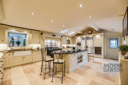
- Price
- Offers in Excess of£1,750,000
- Size
- 7 acres
Cliviger Laithe Farmhouse, Red Lees Road, Burnley, BB10, Cliviger, Lancashire BB10 England
Added on 29/01/2026Farmhouse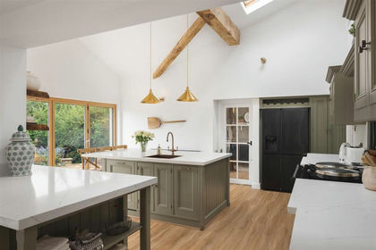
- Price
- Offers Over£1,500,000
- Size
- 5 acres
Church Lane, Bardsey, Leeds, Bardsey cum Rigton, Leeds LS17 England
Added on 02/09/2026House with Land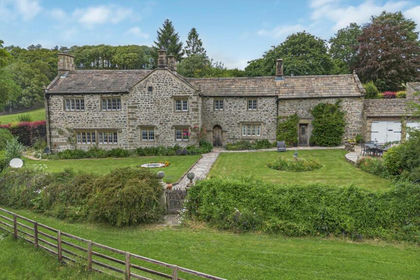
- Price
- £1,850,000
- Size
- 7.11 acres
Brockabank Farm, Eshton. Gargrave, Flasby with Winterburn, North Yorkshire BD23 England
Added on 10/07/2026Country Home
- Price
- Guide Price£1,875,000
- Size
- 11.5 acres
Selby Road, Monk Fryston, Leeds, North Yorkshire, LS25, Monk Fryston, North Yorkshire LS25 England
Added on 21/07/2026House with Land
- Price
- Guide Price£1,875,000
- Size
- 11 acres
Monk Fryston, North Yorkshire, LS25, Monk Fryston, North Yorkshire LS25 England
Added on 10/07/2026Country Home
- Price
- £1,795,000
- Size
- 10 acres
Ripley, Nr Harrogate, Clint cum Hamlets, North Yorkshire HG3 England
Added on 25/07/2026Equestrian property
- Price
- £1,750,000
- Size
- 8 acres
Taylors Farm, Back Lane, Heath Charnock, PR6, Heath Charnock, Lancashire PR6 England
Added on 22/06/2026Farmhouse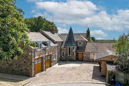
- Price
- £1,595,000
- Size
- 6.2 acres
Added on 19/08/2026House with Land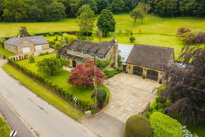
- Price
- Offers in Region of£1,500,000
- Size
- 23 acres
Troway Hill Farm, Moss Valley, Sheffield, South Yorkshire, S21, Eckington, Derbyshire S21 England
Added on 27/06/2026House with Land