Brockabank Farm, Eshton. Gargrave
- Land size
- 7.11 acres
- Bedrooms
- 4
- Bathrooms
- 2
Key Features
- A beautiful Grade II Listed home in 7.11 acres
- Approached along a winding private lane
- Superb gardens and views. 3 stables
- Well maintained & high quality throughout
- 2 Inglenooks fireplaces, mullioned windows, oak floors & much more
- 2 storey barn with gym to the first floor
- Further 2 storey storage building
- A double and single garage & scope for more
- Oak doors and floors, period fittings
- No Forward Chain
Description
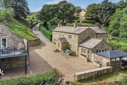
A secluded, stunning Grade II listed country home set within approximately 7.11 acres of beautifully maintained grounds, creating a peaceful and idyllic rural setting. Including 3 stables, a 2 storey barn, a double & single garage, and 2 storey store room.
Recorded in the Domesday Book as a timber building, the property dates back in part to the 1400s and seamlessly combines exceptional period character with high-quality modern living.
A stone-flagged side hall leads to a practical utility / laundry room, which in turn provides access to the integral double garage. Adjacent is a Sub-Zero fridge with 2 cooling drawers, together with a door leading to the garden and a further door into the kitchen.
The charming, dual-aspect kitchen is filled with natural light and enjoys delightful views across the gardens. It features a stone-flagged floor, bespoke Shaker-style cabinetry finished in an elegant duck egg blue with black granite work surfaces, and a Lacanche dual-fuel range cooker, creating a superb space for both everyday living and entertaining.
The impressive solid oak front door, complete with a stone surround and period-style ironmongery, opens into a welcoming stone-flagged entrance hall. Beyond lies the magnificent reception hall, centred around a cosy inglenook fireplace with an open fire, complemented by stone-flagged flooring and an impressive oak staircase. Natural light streams in from a window overlooking the rear terrace, and al fresco dining areas.
Leading from the reception hall is a spacious study, featuring a decorative fireplace, dual-aspect windows and stone flooring, providing an ideal home office or additional reception room.
The elegant dining room retains its (possibly) original herringbone oak flooring together with a feature built-in cupboard and a charming period-style fireplace. Decorated in attractive heritage colours, the room comfortably accommodates an eight-person dining suite and associated furniture, making it perfect for formal dining and entertaining.
The generously proportioned sitting room is a wonderfully cosy yet spacious retreat. A magnificent inglenook fireplace houses a large multi-fuel stove, while dual-aspect windows with window seats provide attractive views over both the front and rear gardens. There is ample space for multiple sofas, armchairs and additional furniture.
A door from the sitting room leads into a rear hallway with direct access to the gardens, a traditional Thomas Crapper WC, and a further connection back to the reception hall.
The bespoke restored return staircase rises to a spacious landing with wide timber floorboards, exposed roof trusses and built-in storage cupboards. A rear-facing window fills the space with natural light while overlooking the gardens.
The stunning family bathroom is beautifully appointed with a freestanding double-ended bath featuring floor-mounted filler taps and hand shower attachment, a Drummonds period-style WC and wash basin, and a striking Jules Verne-style freestanding shower enclosure with monsoon shower head.
The magnificent principal bedroom enjoys grand proportions and showcases wide timber floorboards, an attractive decorative fireplace, exposed beams and timbers, together with delightful views through two sets of exposed stone mullioned windows.
The luxurious en-suite bathroom features a freestanding bath, WC, vanity wash basin and high-quality fixtures and fittings throughout.
The guest bedroom also benefits from a decorative fireplace, wide timber flooring and dual-aspect windows overlooking the gardens.
Bedroom 3 is a further spacious double bedroom enjoying delightful views across the front gardens, complete with exposed roof trusses, built-in cupboards and direct access through to Bedroom 4, a further well-proportioned double bedroom, attractively presented with exposed trusses and purlins, continuing the property's wealth of original architectural character.
Externally, the property offers an exceptional range of gardens, outbuildings and parking. The wraparound country house gardens are predominantly laid to lawn with beautifully stocked herbaceous borders, specimen shrubs and mature trees providing privacy and year-round interest. Several Yorkshire stone-flagged terraces offer wonderful spaces for al fresco dining and outdoor entertaining.
A combination of flagged and cobbled pathways leads to the principal entrance and across the front of the house to the cobbled driveway, providing extensive parking and access to the double garage.
The generous forecourt provides parking for a dozen cars and also serves an excellent range of traditional outbuildings, including three stables, a single garage, a two-storey store and a substantial two-storey barn, with a gymnasium located on the first floor, with access directly onto the gardens. To the rear of these buildings lies a productive kitchen garden together with a dedicated composting area.
Brockerbank Farm is approached from the village of Eshton via a winding single-track crossing a picturesque humpback bridge over Eshton Beck before heading up to this truly outstanding and historic country residence.
In the interests of transparency, a death occurred at the property in 2016. The circumstances of the death were unrelated to the property or its condition.
Buyer & Seller Anti Money Laundering Checks
We are required by HMRC to undertake Anti Money Laundering checks for all buyers and sellers to the contract. These checks are carried out through Kotini, and we make a charge of £35.00 + VAT per buyer. We will also need to see proof of funding. We cannot mark a property Sold Subject to Contract until the checks have been satisfactorily completed.
Map Location
Property details
- Tenure
- Freehold
- Council Tax Band
- G
- Date Posted
- 2026-07-10
Market Value Analysis
Compared with 193 Homes with Land listings in Yorkshire and The Humber (5+ acres).
Utilities & Restrictions
Utilities
- Electricity
- Mains
- Water
- Mains
- Heating
- Oil Heating, Open Fire, Underfloor Heating, Wood Burner
- Broadband
- Cable Internet
- Sewerage
- Septic Tank / Private
Rights & Restrictions
- Public Rights of Way
- Yes
- Private Rights of Way
- Ask Agent
- Listed Property
- Yes
- Restrictions
- Yes
Listed status, conservation areas and planning constraints for this location are in the full report.
Property Features
- Accessibility
- Ask Agent
- Parking
- Garage, Driveway
- Garden
- Garden
Beyond the particulars: planning activity, flood history, heritage and ground risks, checked for this exact spot.
Connectivity
Broadband
Fastest speed available at this postcode
12 Mbps
Standard (10-30 Mbps)
Suitable for
- Web & social
- Music streaming
- Standard video calls
Fixed wireless access may also be an option here.
Mobile signal
Predicted 4G and 5G signal; indoor signal depends on building materials.
Ofcom Connected Nations postcode-level predictions. Speeds and signal are modelled, not measured, and vary between addresses and providers.
Signal is the easy part. Planning activity, flood history and protected designations here are in the full report.
Nearest Schools
Primary
- Gargrave Church of England Primary School1.7 milesOfsted report card · Mar 2026
- Ages
- 3 to 11
- Type
- Academy converter
- Faith
- Church of England
- Cracoe and Rylstone Voluntary Controlled Church of England Primary School2.8 milesNo Ofsted rating
- Ages
- 4 to 11
- Pupils
- 44
- Type
- Voluntary controlled school
- Faith
- Church of England
- Kirkby in Malhamdale United Voluntary Aided Primary School4 milesNo Ofsted rating
- Ages
- 3 to 11
- Pupils
- 55
- Type
- Voluntary aided school
- St Stephen's Catholic Primary School and Nursery, A Voluntary Academy4.3 milesOfsted report card · Feb 2026
- Ages
- 3 to 11
- Pupils
- 148
- Type
- Academy sponsor led
- Faith
- Roman Catholic
- Skipton, Water Street Community Primary School4.4 milesOfsted: Good
- Ages
- 4 to 11
- Pupils
- 215
- Type
- Community school
Secondary
- The Skipton Academy3.9 milesOfsted: Good
- Ages
- 11 to 16
- Pupils
- 736
- Type
- Academy sponsor led
- Skipton Girls' High School4.1 milesOfsted: Good
- Ages
- 11 to 18
- Pupils
- 862
- Type
- Academy converter
- Gender
- Girls
- Ermysted's Grammar School4.2 milesOfsted: Good
- Ages
- 11 to 18
- Pupils
- 836
- Type
- Voluntary aided school
- Gender
- Boys
- Upper Wharfedale School5.6 milesNo Ofsted rating
- Ages
- 11 to 16
- Pupils
- 351
- Type
- Community school
- West Craven High School7.4 milesOfsted: Requires improvement
- Ages
- 11 to 16
- Pupils
- 528
- Type
- Academy converter
Distances are straight-line from the advertised location. Source: the national school registers (DfE, Welsh Government, Scottish Government) and Ofsted.
Schools are just the start: sold prices nearby, planning activity and any flood history are in the full report.
Amenities
Supermarket
GP surgery
Pharmacy
Hospital
Straight-line distances from the advertised location. Sources: NHS records, Geolytix supermarket locations, OS Open Greenspace and the national trails registers.
The area stacks up? Now check the location itself: planning nearby, protected designations and past flooding.
Getting Around
Nearest station
Nearest bus stop
Typical drive times
Straight-line distances from the advertised location; drive times are typical free-flow times over OpenStreetMap road data, so allow more at peak. Public transport locations from DfT NaPTAN.
Easy to reach matters. So do planning activity, flood history and ground risks: all in the full report.
Flood Risk
Environment Agency open data, checked around the advertised map pin for the listed acreage. Long-term risk counts flood defences; the planning map's flood zones do not. Provided by LandSale, not the listing agent, and not part of the agent's particulars. Risk varies across a holding, so verify before committing.
Rivers and the sea
Planning map: Flood Zone 1.
Surface water
Not at the pin: mapped about 10 metres away.
These bandings are the summary. Where this location sits on the flood maps, plus planning activity, heritage and ground risks, is in the full report.
Important notice: Information, maps and tags on this page are drawn from the advertising agent's marketing materials or generated automatically. LandSale has not verified them. Relying on these details is at your own risk, always carry out independent checks before committing to a purchase.
LandSale full disclaimer
Marketing information only - not formal particulars. The details on this website are provided for general guidance and do not constitute an offer or contract. Neither LandSale nor the advertising estate/land agent accepts responsibility for any inaccuracy.
1. Source of information
- Listing content: Core description, asking price, tenure, measurements, photographs and planning history originate from the marketing materials of the advertising estate or land agent. LandSale does not author this content and cannot guarantee its accuracy.
- Automated tags & categorisation: Property type, land-use class, acreage bands and similar labels may be applied by machine-learning models. They are intended as a helpful guide only and may not reflect the property's legal status or permitted use.
- Third-party & enriched data layers: Maps, boundary outlines, planning designations, soil reports, broadband coverage and other environmental or location-based insights are licensed from external suppliers. Such data are supplied “as is", may be incomplete or out of date and are subject to change without notice.
2. Verification required
Prospective purchasers must verify critical matters, including but not limited to planning permission, title boundaries, public rights of way, environmental constraints, acreage, services, access and VAT status, through their own inspections, specialist surveys, legal advisers and the selling agent before relying on the information or entering into any contract.
3. No warranty or liability
LandSale gives no warranty, express or implied, as to the accuracy, completeness or fitness for any particular purpose of the information displayed. LandSale shall not be liable for any loss, damage, cost or expense arising directly or indirectly from any use of or reliance on such information, save where liability may not be excluded by law.
4. Updates & feedback
If you believe any detail on this listing is inaccurate, please let us know. We will investigate and, where appropriate, update the listing or notify the agent.
© LandSale | Version 1.3 - August 2026
Listing agent
Hunters, Skipton
1 High Street, Skipton BD23 1AJ
Similar properties for sale
- Price
- £1,400,000
- Size
- 9 acres
Hollin Hall, Trawden, Trawden Forest, Lancashire BB8 England
Added on 10/09/2026Barn Conversion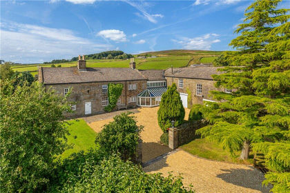
- Price
- Guide Price£2,295,000
- Size
- 5.32 acres
Ilkley, North Yorkshire, LS29, Ilkley, Bradford LS29 England
Added on 25/08/2026House with Land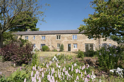
- Price
- Guide Price£1,450,000
- Size
- 3.96 acres
Pateley Bridge, Harrogate, North Yorkshire, High and Low Bishopside, North Yorkshire HG3 England
Added on 02/04/2026House with Land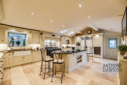
- Price
- Offers in Excess of£1,750,000
- Size
- 7 acres
Cliviger Laithe Farmhouse, Red Lees Road, Burnley, BB10, Cliviger, Lancashire BB10 England
Added on 29/01/2026Farmhouse
- Price
- Guide Price£1,395,000
- Size
- 48.92 acres
Farnley Lane, Farnley, Otley, North Yorkshire, LS21, Farnley, North Yorkshire LS21 England
Added on 25/08/2026House with Land
- Price
- Guide Price£2,250,000
- Size
- 6.92 acres
Farnley Lane, Farnley, Otley, North Yorkshire, LS21, Farnley, North Yorkshire LS21 England
Added on 23/04/2026House with Land
- Price
- Guide Price£2,250,000
- Size
- 13 acres
Carlton Lane, Guiseley, West Yorkshire, LS20, Leeds North West, Leeds LS20 England
Added on 01/07/2026Farmhouse
- Price
- £1,700,000
- Size
- 3.4 acres
Added on 04/06/2026House with Land
- Price
- £1,700,000
- Size
- 4 acres
Added on 04/06/2026House with Land
- Price
- £1,850,000
- Size
- 7.25 acres
High House Lane, Midgley, Luddendenfoot, Halifax, HX2, Calder Valley, Calderdale HX2 England
Added on 04/06/2026Barn Conversion