
Stoneyfield Farm, Drumblade, Huntly, AB54
- Land size
- 18.83 acres
- Bedrooms
- 3
Key Features
- Characterful farm extending to 7.62ha (18.83 acres) or thereby in total
- IACS registered land comprising grass paddocks and c.0.98ha (2.43 acres) of native woodland
- Peaceful yet accessible location east of Huntly, less than 2 miles from the A96
- Bright and spacious farmhouse with annexe - perfect for multigenerational living
- Large general purpose shed and traditional steading with development potential
Description
Local Information
Stonyfield Farm is located just 5 miles to the east of the historic town of Huntly in the county of Aberdeenshire. Originally known as Milton of Strathbogie in the 12th Century, the area was renamed 'Huntly' by Alexander, the 3rd Earl of Huntly in 1506. The settlement was later modernized and given its gridded layout in the 18th Century by the 4th Duke of Gordon, where it was officially given the name it is known by today.
Huntly is a bustling market town and boasts primary and secondary schooling as well as nursery provision along with a community hospital, GP practice and dentists. There is a plethora of essential conveniences including two major supermarkets, fuel stations, convenience stores, independent shops and cafés, and various leisure and sporting facilities. As well as regular bus services to and from Huntly, Huntly Train Station provides regular connections to Aberdeen and Inverness. Aberdeen City is around a 45-minute drive from Stonyfield, offering a range of retail, hospitality and events offerings befitting of the Energy Capital of Europe as well as excellent shopping and two world-class universities. Aberdeen International Airport is some 32 miles away, and offers a range of national and international flight connections.
Agriculture plays a key role in the local Aberdeenshire economy. Huntly is well-placed to serve the agricultural sector, offering dealerships, services and suppliers locally as well as a veterinary practice in the town itself. The local livestock market at Huntly and Thainstone Centre in Inverurie both hold regular weekly sheep and cattle sales throughout the year, attracting buyers from across the country. Local and national livestock haulage is easily supplied in the area.
Description
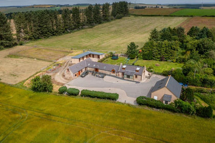
Stonyfield is a versatile and charming small farm which is well placed for seamlessly blending the qualities of rural peaceful living with the convenience of being a short drive from Huntly. This excellent rural package comprises an extended traditional farmhouse which has been recently adapted to provide a useful annexe for multi-generational living; large general purpose outbuilding, traditional steading, private woodlands, lush grass paddocks and two large ponds.
Entering the property from the yard area and patio, you walk straight into the well appointed farmhouse dining kitchen with double aspect windows. Leading through the short passage you pass the useful utility room and shower room, which leads into the large, bright living room. This room really is the heart of this home boasting a cosy woodburning stove and being flooded with natural light through the three large windows overlooking the duck pond. Off the central hallway is the vestibule with coat cupboard at the front door, under-stair storage which could easily be returned to a WC, feature staircase and the doorway into the annexe.
The well-proportioned annexe is extremely bright and airy with double aspect windows and private entrance straight into the garden spaces. There is built-in storage and a small WC / kitchenette and en-suite bedroom. This space could very easily be returned to being two separate en-suite bedrooms to provide five bedrooms overall.
On the first floor there is a large room-in-roof bedroom with small bedroom leading off, family bathroom and the master bedroom which comprises masses of built-in storage and useful walk-in attic room.
General Purpose Shed
The steel portal frame shed, measuring approximately 24m x 18m has most recently been used for the rearing and housing of laying hens and ducks, however, has the versatility to be returned to a large open plan building for a variety of uses. For those looking to convert the building into equestrian use, there are three existing concrete stable boxes in place which can be added to with lots of space for adding new purpose-built boxes. The building has been fitted with electric and water and features double sliding doors at both ends. The building has a concrete floor and is clad with metal box profile sheeting. There is space to extend the building, subject to obtaining the necessary consents.
Traditional Steading
The traditional buildings situated to the north of the farmhouse provides useful storage and a sheltered courtyard area in the square. The steadings have development potential, subject to obtaining all necessary consents. The vendors had historically looked to develop the site for holiday let
accommodation and have an indicative plan which can be shared if interested. The site has previously had planning permission for the development of the steading into three residential units and a business unit (APP/2007/0555).
Property Details
Home Report:
Home Report available online.
EPC:
Band E.
Council Tax:
Band F.
Services:
Private water, mains electricity. Oil central heating and woodburning stoves. Private drainage to septic tank. Water and electric to buildings. Water to fields.
Included in Sale:
House:
All floor coverings, blinds, curtains, light fittings and shades.
Externally:
All fencing and gates, pens in shed (if required). Mobile poultry houses in paddocks, feed bins, feeders and drinkers, feed, bedding, egg packing equipment and materials all available by separate negotiation. Livestock also available by separate negotiation if required.
The Land
The IACS Registered land at Stonyfield comprises four parcels which have been sub-divided to provide several smaller paddocks. The land is all classified as Grade 3(2) by the James Hutton Institute and lies 162m to 188m above sea level. Each paddock has access to piped water. The land has been used for the grazing of livestock and poultry since 2023 but would be well suited to cropping or equestrian use. For those looking to keep horses, good hacking is available direct from the farm and nearby, with The Cabin Equestrian Centre located around 23 miles south-east, whilst Bogenraith Equestrian Centre is around 43 miles south.
Stoneyfield Stone Circle
The remains of the Stoneyfield Stone Circle is a scheduled monument, located in the paddock to the north of the farm. The protected site is listed as a prehistoric ritual and funerary. It is believed that the stone circle originally consisted of twelve stones with only two now standing.
Basic Payment Scheme (BPS)
BPS Entitlements available by separate negotiation. It is understood there are 5.02 units of Region 1 and 1.65 units of Region 2 entitlements available with the property. Non LFA. Payments relating to the 2026 scheme year to be retained by the vendor.
Directions
From Huntly, head south on the A96 for around 3 miles and turn off to left for 'Thomastown'. Continue along this road through the hamlet of Thomastown until you reach the staggered junction. Continue straight ahead where Stonyfield Farm is located on your right hand side after around 0.5 mile.
Viewings
To arrange a formal viewing contact Aberdeen & Northern Estates on (Mon - Fri, 9am - 5pm).
Health & Safety
Caution and due care should be exercised at all times during any viewing or inspection particularly in relation to any livestock present, working machinery or materials and equipment.
Services:
Private drainage, private water & mains electricity. uPVC double glazing. Oil central heating.
Local Authority:
Aberdeenshire Council, 23-25 Gordon Street, Huntly, AB54 8AL
EPC:
Band E
Council Tax:
Band F
Entry:
By arrangement BPS Entitlements: Available by separate negotiation.
Mineral Rights & Sporting Rights:
Included in the sale, insofar as they are owned.
Note:
Prospective purchasers should note that unless their interest in the property is formally intimated to the selling agents following inspection, the agents cannot guarantee that notice of a closing date for offers will be advised and consequently the property may be sold without notice.
Anti Money Laundering Compliance:
In accordance with The Money Laundering, Terrorist Financing and Transfer of Funds (Information on the Payer) Regulations 2017, we are required to carry out checks and due diligence on property purchasers. If an offer has been accepted, the purchaser(s) will need to provide proof of identity, residence and proof of funds, as a minimum, prior to any transaction proceeding.
Offers:
Formal offers, in the acceptable Scottish form should be submitted, along with the relevant anti-money laundering paperwork in accordance with The Money Laundering, Terrorist Financing and Transfer of Funds (Information on the Payer) Regulations 2017, through a Scottish Solicitor, to the Selling Agent.
Servitude Rights, Burdens and Wayleaves:
The property is sold subject to and with the benefit of all servitude rights, including rights of access and rights of way, whether public or private. The buyer(s) will be held to have satisfied himself/themselves as to the nature of all such servitude rights and others.
Title:
The buyer(s) shall be bound to accept the title as it presently stands in the name of the seller(s) and the conveyance in favour of the buyer(s) shall be subject to all the exceptions, reservations, burdens and conditions presently contained in the title deeds. There shall be excepted from warrandice in the conveyance in favour of the buyer(s) any leases, tenancies, tenants' rights, missives, agreements, rights of possession, rights of way, access rights, and sewerage and drainage facilities, and all other servitudes and other rights without prejudice to the right of the buyer(s) to quarrel or impugn the same on any ground not inferring warrandice against the seller(s).
Map Location
Property details
- Tenure
- Ask Agent
- Council Tax Band
- Ask Agent
- Date Posted
- 2026-05-30
Market Value Analysis
Compared with 53 Farms & Smallholdings listings in Scotland (10+ acres).
Utilities & Restrictions
Utilities
- Electricity
- Ask Agent
- Water
- Ask Agent
- Heating
- Ask Agent
- Broadband
- Ask Agent
- Sewerage
- Ask Agent
Rights & Restrictions
- Public Rights of Way
- Ask Agent
- Private Rights of Way
- Ask Agent
- Listed Property
- Ask Agent
- Restrictions
- Ask Agent
Listed status, conservation areas and planning constraints for this location are in the full report.
Property Features
- Accessibility
- Ask Agent
- Parking
- Ask Agent
- Garden
- Garden
Beyond the particulars: planning activity, flood history, heritage and ground risks, checked for this exact spot.
Connectivity
Broadband
Fastest speed available at this postcode
1.8 Gbps
Standard (10-30 Mbps)
Suitable for
- 4K streaming on every screen
- Full-time home working
- Online gaming & big downloads
Mobile signal
Predicted 4G and 5G signal; indoor signal depends on building materials.
Ofcom Connected Nations postcode-level predictions. Speeds and signal are modelled, not measured, and vary between addresses and providers.
Signal is the easy part. Planning activity, flood history and protected designations here are in the full report.
Nearest Schools
Primary
- Drumblade School1.3 miles
- Pupils
- 48
- Type
- Non-denominational
- Largue School4 miles
- Pupils
- 9
- Type
- Non-denominational
- Gordon Primary School4.1 miles
- Pupils
- 357
- Type
- Non-denominational
- Forgue School4.5 miles
- Pupils
- 18
- Type
- Non-denominational
- Kennethmont School6 miles
- Pupils
- 65
- Type
- Non-denominational
Secondary
- The Gordon Schools4.1 miles
- Pupils
- 665
- Type
- Non-denominational
- Turriff Academy11 miles
- Pupils
- 623
- Type
- Non-denominational
- Keith Grammar School13 miles
- Pupils
- 370
- Type
- Non-denominational
- Alford Academy14 miles
- Pupils
- 733
- Type
- Non-denominational
- Meldrum Academy15 miles
- Pupils
- 1,004
- Type
- Non-denominational
Distances are straight-line from the advertised location. Source: the national school registers (DfE, Welsh Government, Scottish Government) and Ofsted.
Schools are just the start: planning activity, heritage and any flood history here are in the full report.
Amenities
Supermarket
GP surgery
Pharmacy
Straight-line distances from the advertised location. Sources: NHS records, Geolytix supermarket locations, OS Open Greenspace and the national trails registers.
The area stacks up? Now check the location itself: planning nearby, protected designations and past flooding.
Getting Around
Nearest station
Nearest bus stop
Typical drive times
Straight-line distances from the advertised location; drive times are typical free-flow times over OpenStreetMap road data, so allow more at peak. Public transport locations from DfT NaPTAN.
Easy to reach matters. So do planning activity, flood history and ground risks: all in the full report.
Flood Risk
SEPA open data, checked around the advertised map pin for the listed acreage. Provided by LandSale, not the listing agent, and not part of the agent's particulars. Risk varies across a holding, so verify before committing.
Rivers and the sea
Surface water
Not at the pin: mapped about 10 metres away.
These bandings are the summary. Where this location sits on the flood maps, plus planning activity, heritage and ground risks, is in the full report.
Important notice: Information, maps and tags on this page are drawn from the advertising agent's marketing materials or generated automatically. LandSale has not verified them. Relying on these details is at your own risk, always carry out independent checks before committing to a purchase.
LandSale full disclaimer
Marketing information only - not formal particulars. The details on this website are provided for general guidance and do not constitute an offer or contract. Neither LandSale nor the advertising estate/land agent accepts responsibility for any inaccuracy.
1. Source of information
- Listing content: Core description, asking price, tenure, measurements, photographs and planning history originate from the marketing materials of the advertising estate or land agent. LandSale does not author this content and cannot guarantee its accuracy.
- Automated tags & categorisation: Property type, land-use class, acreage bands and similar labels may be applied by machine-learning models. They are intended as a helpful guide only and may not reflect the property's legal status or permitted use.
- Third-party & enriched data layers: Maps, boundary outlines, planning designations, soil reports, broadband coverage and other environmental or location-based insights are licensed from external suppliers. Such data are supplied “as is", may be incomplete or out of date and are subject to change without notice.
2. Verification required
Prospective purchasers must verify critical matters, including but not limited to planning permission, title boundaries, public rights of way, environmental constraints, acreage, services, access and VAT status, through their own inspections, specialist surveys, legal advisers and the selling agent before relying on the information or entering into any contract.
3. No warranty or liability
LandSale gives no warranty, express or implied, as to the accuracy, completeness or fitness for any particular purpose of the information displayed. LandSale shall not be liable for any loss, damage, cost or expense arising directly or indirectly from any use of or reliance on such information, save where liability may not be excluded by law.
4. Updates & feedback
If you believe any detail on this listing is inaccurate, please let us know. We will investigate and, where appropriate, update the listing or notify the agent.
© LandSale | Version 1.3 - August 2026
Listing agent
Aberdeen & Northern (Estates) Ltd, Inverurie
Thainstone Agricultural Centre, Inverurie, AB51 5XZ
View agent profileSimilar properties for sale
- Price
- Offers Over£440,000
- Size
- 9 acres
Ythanwells, Huntly, AB54, Gordon and Buchan, Aberdeenshire AB54 Scotland
Added on 08/08/2026Equestrian property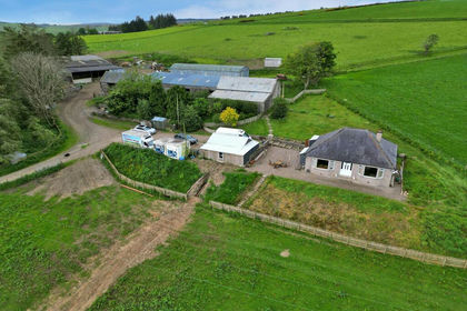
- Price
- Offers in Excess of£445,000
- Size
- 25.75 acres
Upper Lynemore, Keith, AB55, Moray West, Nairn and Strathspey, Moray AB55 Scotland
Added on 19/02/2026Smallholding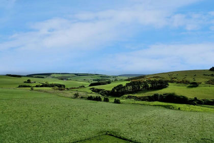
- Price
- Offers Over£445,000
- Size
- 25.75 acres
Added on 19/02/2026Farmland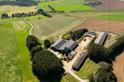
- Price
- £550,000
- Size
- 92.81 acres
Added on 18/09/2026Farmland
- Price
- Offers Over£585,000
- Size
- 12 acres
Added on 29/01/2026Equestrian property
- Price
- Offers in Excess of£665,000
- Size
- 28 acres
Drybridge MORAY COAST, Aberdeenshire North and Moray East, Moray AB56 Scotland
Added on 08/10/2026Equestrian property
- Price
- Offers in Excess of£555,000
- Size
- 20 acres
Newburgh, Ellon, AB41, Gordon and Buchan, Aberdeenshire AB41 Scotland
Added on 24/08/2026House with Land
- Price
- Offers Over£599,995
- Size
- 11 acres
Hatton, Peterhead, AB42, Aberdeenshire North and Moray East, Aberdeenshire AB42 Scotland
Added on 16/06/2026House with Land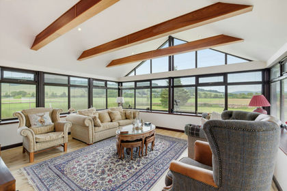
- Price
- Offers Over£670,000
- Size
- 25 acres
Mill House, Strachan, Banchory, AB31, West Aberdeenshire and Kincardine, Aberdeenshire AB31 Scotland
Added on 02/07/2026House with Land