Llanfair Dyffryn Clwyd, Ruthin, Denbighshire
- Land size
- 1.62 acres
- Bedrooms
- 4
- Bathrooms
- 3
Key Features
- 4 bedrooms
- 3 reception rooms
- 2 bathrooms
- Grade II listed
- Renovated to conservation standard, with well-presented accommodation
- Flexible accommodation
- Split over three main levels
- Approximately 307 sq m (3,313 sq ft) of living accommodation
- Approximately 1.62 acres
- EPC rating E
Description
One half of a Grade II listed Elizabethan hall, situated on the edge of a sought-after village. Occupying a substantial plot, and offering exceptional views across the Clwydian Range.
Eyarth Old Hall is a substantial Grade II listed country residence, located within an idyllic semirural setting, a short distance from the popular community village of Llanfair Dyffryn-Clwyd. The property is steeped in history, with its origins believed to date back 16th century. Although, there is evidence to suggest sections of the property pre-dates this. The hall was constructed in 1599, by Rhys Williams, who was the verger and assistant to Gabriel Goodman, the 5th Dean of Westminster Abbey during the reign of Elizabeth I.
Over the years the hall has undergone a vast array of extension and modification, with a redesign in the mid 19th century.
In recent times, the property has been split into two residences by the current owners, with meticulous care and attention evident within the renovation works, which have been completed to conservation standard.
Ground floor
Double timber doors open into a welcoming entrance vestibule, which is laid with oak flooring and features an original brick-built bread oven, now acting as a charming feature. A doorway within the vestibule flows into an impressive drawing room. The room features vaulted ceilings with exposed trusses and is laid with a slate flooring. The predominant feature is an impressive stone inglenook fireplace, with exposed bressummer beam.
To the left of the fireplace is a recessed storage cupboard. Also within the room is an external door leading out to a south-facing terrace courtyard and a set of stairs which lead down to the kitchen courtyard.
The stairs lead you down to a formal dining room, which is impressively finished with full height panelling and exposed ceilings beams. Steps lead into a snug, which features a wood burning stove inset within a stone fire surround. The snug provides entry into a boot room with external access, which leads to the “Trappers Porch” and also a short staircase, which leads down into the heart of the home in the form of a wonderful breakfast kitchen. The kitchen has original parquet flooring and is fitted with a range of floor and full height shaker style cabinets under honed granite work surfaces. The main feature of the room is a substantial inglenook fireplace which hosts an inset Aga flanked by cabinets. The kitchen provides ample space for a breakfast table and hosts a range of integrated appliances. The kitchen also features working shutters on the window.
From the kitchen a few steps lead down to a pantry and utility room, which also provides an additional rear entry, leading out to the kitchen courtyard.
At the opposing end of the kitchen, an inner hallway hosting the main staircase provides entry into a home office with a dressing room cloakroom area and a WC.
First and Second Floors
The staircase rises and forks to the principal and guest bedrooms, each of which benefit from a range of custom fitted wardrobes and working shutters to the windows. The bedrooms are serviced by an ensuite bathroom in the guest bedroom and a shower room in the principal suite.
The main staircase rises to a further two bedrooms, the top level bedroom has been recently converted by the current owner to provide a further spacious bedroom with high vaulted ceilings, a mezzanine level and fitted wardrobes.
The property is approached along a long sweeping driveway, which is shared between the neighbouring properties within the development. The drive leads to a gateway which marks the start of the property’s boundary. The drive passes a substantial building with original stable doors which includes a garage, log store and workshop space suitable for storage or stabling. After the outbuilding, a wrought iron gate opens onto a large, gravelled driveway, affording space for multiple vehicles to be securely parked.
The main gardens are located to three sides of the residence and are laid to lawn flanking the driveway, the lawn gently slopes to a mature box hedgerow where a gateway opens into an orchard and a tranquil garden. From here, a gateway leads to a terrace, which basks in the early morning sun. At the opposing side of the property there is a further lawned garden hosting a summer house. This section is raised and has an external set of steps leading down to the Trappers Porch entrance and a further outside seating terrace.
There is a right of way off the drive, with a short walk to the beautiful Eyarth Rocks conservation area and SSSI.
Situation
Eyarth Old Hall is located within a small hamlet of properties on the fringes of Llanfair Dyffryn Clwyd, a charming village, nestled in the scenic Vale of Clwyd and a short distance from the medieval market town of Ruthin.
Known for its picturesque surroundings and rural tranquillity, the village has a rich history, featuring a beautiful parish church, St Cynfarch and Mary’s, which is a notable landmark with parts dating back to the 13th century.
The area is surrounded by rolling hills and farmland, making it a popular spot for walkers and those seeking a peaceful countryside retreat.
On the recreational front, the area is particularly well serviced, with the local towns and villages hosting an array of sporting and leisure facilities.
Regarding schooling, the village hosts a recently built primary school, with further availability in the surrounding towns and villages. Ruthin hosts a state and public school, while highly regarded independent schools include King’s and Queen’s are located in Chester.
The property is well-placed for commuting to Chester and the Commercial centres of the Northwest, with access to the North Wales Expressway A55 within a commutable distance.
Fixtures and fittings
All fixtures, fittings and furniture such as curtains, light fittings, garden ornaments and statuary are excluded from the sale. Some may be available by separate negotiation.
Services
Water - borehole, septic tank, mains electric and oil heating. None of the services or appliances, heating installations, plumbing or electrical systems have been tested by the selling agents.
We understand that the current broadband download speed at the property is around [xx Mbps], however please note that results will vary depending on the time a speed test is carried out. The estimated fastest download speed currently achievable for the property postcode area is around 22 Mbps (data taken from checker.ofcom.org.uk on 30/04/2025). Actual service availability at the property or speeds received may be different.
We understand that the property is likely to have current mobile coverage (data taken from checker.ofcom.org.uk on
30/05/2025). Please note that actual services available may be different depending on the particular circumstances, precise location and network outages.
Tenure
The property is to be sold freehold with vacant possession.
Local Authority
Denbighshire County Council
Council Tax Band G
Public rights of way, wayleaves and easements
The property is sold subject to all rights of way, wayleaves and easements whether or not they are defined in this brochure.
Plans and boundaries
The plans within these particulars are based on Ordnance Survey data and provided for reference only. They are believed to be correct but accuracy is not guaranteed. The purchaser shall be deemed to have full knowledge of all boundaries and the extent of ownership. Neither the vendor nor the vendor’s agents will be responsible for defining the boundaries or the ownership thereof.
Viewings
Strictly by appointment through Fisher German LLP.
Map Location
Property details
- Tenure
- Freehold
- Council Tax Band
- G
- Date Posted
- 2026-05-21
Market Value Analysis
Compared with 1,043 Homes with Land listings in Wales (1+ acres).
Energy Performance Certificate
Energy Efficiency Rating
Based on UK Energy Performance Certificate standards (EU Directive 2002/91/EC)
Running costs are one side. Planning activity, flood history and ground risks for this location are in the full report.
Utilities & Restrictions
Utilities
- Electricity
- Ask Agent
- Water
- Ask Agent
- Heating
- Ask Agent
- Broadband
- Ask Agent
- Sewerage
- Ask Agent
Rights & Restrictions
- Public Rights of Way
- Ask Agent
- Private Rights of Way
- Ask Agent
- Listed Property
- Ask Agent
- Restrictions
- Ask Agent
Listed status, conservation areas and planning constraints for this location are in the full report.
Property Features
- Accessibility
- Ask Agent
- Parking
- Parking Available
- Garden
- Garden
Beyond the particulars: planning activity, flood history, heritage and ground risks, checked for this exact spot.
Connectivity
Broadband
Fastest speed available at this postcode
1.8 Gbps
Gigabit full fibre
Suitable for
- 4K streaming on every screen
- Full-time home working
- Online gaming & big downloads
Mobile signal
Predicted 4G and 5G signal; indoor signal depends on building materials.
Ofcom Connected Nations postcode-level predictions. Speeds and signal are modelled, not measured, and vary between addresses and providers.
Signal is the easy part. Planning activity, flood history and protected designations here are in the full report.
Nearest Schools
Primary
- Ysgol Llanfair Dyffryn Clwyd0.8 miles
- Pupils
- 122
- Type
- Nursery, Infants & Juniors
- Language
- Dual language school / provision (Welsh and English) (including transitional)
- Ysgol Pentrecelyn1.5 miles
- Pupils
- 27
- Type
- Nursery, Infants & Juniors
- Language
- Welsh medium school / provision (including transitional)
- Ysgol Borthyn2.6 miles
- Pupils
- 101
- Type
- Nursery, Infants & Juniors
- Language
- English medium school / provision
- Ysgol Carreg Emlyn2.7 miles
- Pupils
- 59
- Type
- Nursery, Infants & Juniors
- Language
- Welsh medium school / provision (including transitional)
- Ysgol Pen Barras2.8 miles
- Pupils
- 293
- Type
- Nursery, Infants & Juniors
- Language
- Welsh medium school / provision (including transitional)
Secondary
- Ysgol Brynhyfryd2.6 miles
- Pupils
- 1,121
- Type
- Secondary (ages 11-19)
- Language
- Dual language school / provision (Welsh and English) (including transitional)
- Denbigh High School8.6 miles
- Pupils
- 497
- Type
- Secondary (ages 11-19)
- Language
- English medium school / provision
- Alun School9 miles
- Pupils
- 1,480
- Type
- Secondary (ages 11-19)
- Language
- English medium school / provision
- Maes Garmon9.1 miles
- Pupils
- 578
- Type
- Secondary (ages 11-19)
- Language
- Welsh medium school / provision (including transitional)
- Ysgol Dinas Bran9.1 miles
- Pupils
- 1,022
- Type
- Secondary (ages 11-19)
- Language
- Dual language school / provision (Welsh and English) (including transitional)
Distances are straight-line from the advertised location. Source: the national school registers (DfE, Welsh Government, Scottish Government) and Ofsted.
Schools are just the start: sold prices nearby, planning activity and any flood history are in the full report.
Amenities
Supermarket
GP surgery
Pharmacy
Green space
Straight-line distances from the advertised location. Sources: NHS records, Geolytix supermarket locations, OS Open Greenspace and the national trails registers.
The area stacks up? Now check the location itself: planning nearby, protected designations and past flooding.
Getting Around
Nearest station
Nearest bus stop
Typical drive times
Straight-line distances from the advertised location; drive times are typical free-flow times over OpenStreetMap road data, so allow more at peak. Public transport locations from DfT NaPTAN.
Easy to reach matters. So do planning activity, flood history and ground risks: all in the full report.
Flood Risk
Natural Resources Wales open data, checked around the advertised map pin for the listed acreage. Long-term risk counts flood defences; the planning map's flood zones do not. Provided by LandSale, not the listing agent, and not part of the agent's particulars. Risk varies across a holding, so verify before committing.
Rivers and the sea
Planning map: Flood Zone 1.
Surface water
These bandings are the summary. Where this location sits on the flood maps, plus planning activity, heritage and ground risks, is in the full report.
Important notice: Information, maps and tags on this page are drawn from the advertising agent's marketing materials or generated automatically. LandSale has not verified them. Relying on these details is at your own risk, always carry out independent checks before committing to a purchase.
LandSale full disclaimer
Marketing information only - not formal particulars. The details on this website are provided for general guidance and do not constitute an offer or contract. Neither LandSale nor the advertising estate/land agent accepts responsibility for any inaccuracy.
1. Source of information
- Listing content: Core description, asking price, tenure, measurements, photographs and planning history originate from the marketing materials of the advertising estate or land agent. LandSale does not author this content and cannot guarantee its accuracy.
- Automated tags & categorisation: Property type, land-use class, acreage bands and similar labels may be applied by machine-learning models. They are intended as a helpful guide only and may not reflect the property's legal status or permitted use.
- Third-party & enriched data layers: Maps, boundary outlines, planning designations, soil reports, broadband coverage and other environmental or location-based insights are licensed from external suppliers. Such data are supplied “as is", may be incomplete or out of date and are subject to change without notice.
2. Verification required
Prospective purchasers must verify critical matters, including but not limited to planning permission, title boundaries, public rights of way, environmental constraints, acreage, services, access and VAT status, through their own inspections, specialist surveys, legal advisers and the selling agent before relying on the information or entering into any contract.
3. No warranty or liability
LandSale gives no warranty, express or implied, as to the accuracy, completeness or fitness for any particular purpose of the information displayed. LandSale shall not be liable for any loss, damage, cost or expense arising directly or indirectly from any use of or reliance on such information, save where liability may not be excluded by law.
4. Updates & feedback
If you believe any detail on this listing is inaccurate, please let us know. We will investigate and, where appropriate, update the listing or notify the agent.
© LandSale | Version 1.3 - August 2026
Listing agent
Fisher German, Covering the North West
Covering the North West
Similar properties for sale
- Price
- £825,000
- Size
- 2.43 acres
Llanfair Dyffryn Clwyd, Ruthin, LL15, Llanfair Dyffryn Clwyd, Denbighshire LL15 Wales
Added on 10/10/2026Country Home Added on 02/07/2026Barn Conversion
- Price
- Offers in Region of£800,000
- Size
- 2.7 acres
Added on 28/04/2026Farmhouse
- Price
- Offers in Excess of£850,000
- Size
- 5.63 acres
Llanrhaeadr, Denbigh, Denbighshire, Cyffylliog, Denbighshire LL15 Wales
Added on 14/08/2026House with Land
- Price
- Offers in Excess of£700,000
- Size
- 1.63 acres
Llanarmon-yn-Ial, Mold, Denbighshire, Llanarmon-yn-Ial, Denbighshire CH7 Wales
Added on 29/01/2026House with Land
- Price
- £985,000
- Size
- 4.12 acres
Added on 10/10/2026Country Home
- Price
- Offers Over£985,000
- Size
- 7.5 acres
Glan Llyn Farmhouse, Pant Du Road, Mold, CH7, Llanarmon-yn-Ial, Denbighshire CH7 Wales
Added on 29/01/2026Farmhouse
- Price
- Guide Price£950,000
- Size
- 1.33 acres
Llangynhafal, Denbigh, Denbighshire, Llangynhafal, Denbighshire LL16 Wales
Added on 29/01/2026House with Land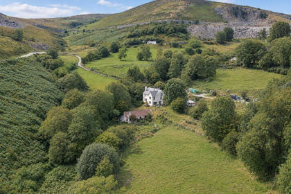
- Price
- £680,000
- Size
- 45 acres
Horseshoe Pass, Llangollen, Llantysilio, Denbighshire LL20 Wales
Added on 29/01/2026Smallholding
- Price
- Offers in Region of£650,000
- Size
- 1.36 acres
Bryn Hallen Mawr, Melin Y Wig, LL21, Betws Gwerfil Goch, Denbighshire LL21 Wales
Added on 29/07/2026Barn Conversion