Framlingham, Suffolk
- Land size
- 1.14 acres
- Bedrooms
- 4
- Bathrooms
- 2
Description
Entrance hall, open plan living/kitchen/breakfast room, dining room, snug/bedroom four, utility room, cloakroom and bedroom three with en-suite shower.
Two first floor bedrooms and family bathroom.
Off-road parking for two to three vehicles.
Grounds extending to 1.14 acres
Location
The property is located on the outskirts of the popular market town of Framlingham. The town is well equipped with various amenities, including a doctors surgery, Sir Robert Hitcham’s CEVA Primary School & Nursery, Thomas Mills High School and Framlingham College. There is a good selection of independent shops and businesses within the town including cafés, restaurants, hairdressers, antique shops, a travel agency, nursery, vets and delicatessen. Framlingham is also home to the Crown Hotel and a Co-operative supermarket. In recent years Framlingham has often featured as the number one place to live in the country and is perhaps best known for its magnificent castle.
Framlingham is surrounded by delightful villages, many of which have popular public houses. There are lovely walks from the town into the surrounding countryside, and amenities such as golf in nearby locations such as Cretingham (6 miles), Woodbridge (12 miles) and Aldeburgh (14 miles). The world famous Snape Maltings Concert Hall is nearby (10 miles), and there is also bird watching at the RSPB centre at Minsmere (14 miles). The property is only miles from the coast, with easy access to the popular destinations of Southwold, Dunwich, Thorpeness and Orford. The county town of Ipswich lies approximately 18 miles to the south-west and from here there are regular services to London’s Liverpool Street, which are scheduled to take just over an hour.
Directions
Leaving the agent’s Framlingham office, turn left and take the first turning on the left into Fore Street. Continue along Fore Street to the top of the hill on Haynings Corner bearing left into Badingham Road. Continue for a short while down this road and the property can be found on the left hand side.
For those using the What3Words app: ///blazing.deal.petulant
Description
5 Badingham Road is a beautifully unique home, thoughtfully designed and built by the current owner. Nestled on a plot of just over an acre with gently undulating field views to the rear, this charming property combines space, versatility, and rural tranquillity. Constructed with timber-clad elevations beneath a pitched tiled roof, the home offers flexible accommodation suitable for multi-generational living, with one bedroom benefitting from independent access and its own en-suite shower room. Heating is provided via a solid-fuel Rayburn, that heats water in conjunction with the immersion heater. This is further supported by the recent installation of solar panels which raise the efficiency of the property. There is also double glazing throughout.
During the current owner’s tenure, the gardens to the side have been beautifully landscaped to create a wonderful cottage-style garden with a covered veranda, perfect for outdoor relaxation. To the rear lies a timber art studio, fully insulated and equipped with power and lighting, alongside a wildflower meadow and an established orchard stocked with a variety of fruit trees and wild blooms.
Ground Floor
A welcoming entrance hall with pamment tiled flooring leads to the utility room and cloakroom, as well as to the snug/occasional fourth bedroom, an attractive dual-aspect room with views to the rear. The inner lobby, with stairs to the first floor and understairs storage, opens into a spacious open-plan kitchen/living/breakfast room with pamment tiled flooring throughout. This bright dual-aspect space enjoys multiple garden views, with hand-built kitchen units set beneath slate worktops, a double electric oven with four-ring hob and extractor, space for a fridge, and a solid-fuel 2 oven Rayburn. A connecting doorway leads to the dining room featuring a partially vaulted ceiling, Velux window, wooden flooring and a range of built-in cupboards and with direct access to the garden. From here, a door leads to bedroom three, currently used as a studio, with slate flooring, Velux window and steps to an independent external door. The adjoining en-suite wet room includes a mains-fed shower, WC and pedestal basin, all finished with ceramic tiles.
First Floor
The first-floor landing benefits from stair lighting, a Velux window and eaves storage. Bedroom one enjoys rear views, a Velux window and a fitted sink unit with storage beneath. Bedroom two is a light room with dual aspects via front and side windows. It is currently used as an office with built-in eaves storage. A well-appointed family bathroom, featuring a panelled bath with mixer tap, pedestal basin, concealed cistern WC, Velux window and heated towel radiator completes the accommodation.
Outside
The property is approached from the highway via a driveway providing off-road parking for two to three vehicles, bordered by an established cottage-style garden with flower beds. To the side of the property, a covered veranda opens to a private side garden with pathways, a manmade pond, cottage-style flower beds, a central pergola and a Quince tree. There is also a timber-framed greenhouse and private seating area.
To the rear of the property are wildflower meadows and orchards with a variety of fruit trees, including apple and soft fruit. Beyond this is a fenced area containing a range of beehives. A further gated access opens onto an additional parcel of land adjoining the boundary. From the rear of the property, a paved terrace runs beneath a pergola and leads to a purpose-built studio and workshop, which is timber-framed, insulated with power and light connected and featuring windows to the side and rear together with three skylights. The property benefits from outside taps. The gardens and grounds enjoy outstanding undulating views to the rear.
Viewing Strictly by appointment with the agent.
Services Mains water and electricity. Private sewage treatment plant which is located on the land with number 5 but is also shared with number 3 Badingham Road.
Broadband To check the broadband coverage available in the area click this link –
Mobile Phones To check the mobile phone coverage in the area click this link –
EPC Rating = C (Copy available from the agents upon request).
Council Tax Band D; £2,246.91payable per annum 2025/2026
Local Authority East Suffolk Council; East Suffolk House, Station Road, Melton, Woodbridge, Suffolk IP12 1RT; Tel: .
NOTES
1. Every care has been taken with the preparation of these particulars, but complete accuracy cannot be guaranteed. If there is any point, which is of particular importance to you, please obtain professional confirmation. Alternatively, we will be pleased to check the information for you. These Particulars do not constitute a contract or part of a contract. All measurements quoted are approximate. The Fixtures, Fittings & Appliances have not been tested and therefore no guarantee can be given that they are in working order. Photographs are reproduced for general information and it cannot be inferred that any item shown is included. No guarantee can be given that any planning permission or listed building consent or building regulations have been applied for or approved. The agents have not been made aware of any covenants or restrictions that may impact the property, unless stated otherwise. Any site plans used in the particulars are indicative only and buyers should rely on the Land Registry/transfer plan.
2. The Money Laundering, Terrorist Financing and Transfer of Funds (Information on the Payer) Regulations 2017 require all Estate Agents to obtain sellers’ and buyers’ identity.
3. The vendor has completed a Property Information Questionnaire about the property and this is available to be emailed to interested parties.
4. There is a right of way in favour of number 5 across the pathway from the retained driveway to the side of number three for emptying the sewage treatment plant.
5. There is a right of way in favour of number 3 Badingham Road, vehicular and pedestrian to access their driveway and garage/parking.
February 2026
Map Location
Property details
- Tenure
- Freehold
- Council Tax Band
- D
- Date Posted
- 2026-05-21
Market Value Analysis
Compared with 1,216 Homes with Land listings in East Anglia (1+ acres).
Utilities & Restrictions
Utilities
- Electricity
- Mains
- Water
- Mains
- Heating
- Electric Heating, Underfloor Heating
- Broadband
- Ask Agent
- Sewerage
- Septic Tank / Private
Rights & Restrictions
- Public Rights of Way
- Ask Agent
- Private Rights of Way
- Ask Agent
- Listed Property
- Ask Agent
- Restrictions
- Ask Agent
Listed status, conservation areas and planning constraints for this location are in the full report.
Property Features
- Accessibility
- Ask Agent
- Parking
- Off-Street Parking
- Garden
- Private Garden
Beyond the particulars: planning activity, flood history, heritage and ground risks, checked for this exact spot.
Connectivity
Broadband
Fastest speed available at this postcode
1 Gbps
Gigabit full fibre · available to 86% of premises
Suitable for
- 4K streaming on every screen
- Full-time home working
- Online gaming & big downloads
Mobile signal
Outdoor predictions; indoor signal depends on building materials.
Ofcom Connected Nations postcode-level predictions. Speeds and signal are modelled, not measured, and vary between addresses and providers.
Signal is the easy part. Planning activity, flood history and protected designations here are in the full report.
Nearest Schools
Primary
- Framlingham Sir Robert Hitcham's Church of England Voluntary Aided Primary School892 metresOfsted: Good
- Ages
- 3 to 11
- Pupils
- 311
- Type
- Voluntary aided school
- Faith
- Church of England
- Dennington Church of England Primary School2.1 milesOfsted: Good
- Ages
- 4 to 11
- Pupils
- 66
- Type
- Academy converter
- Faith
- Church of England
- Easton Primary School3.4 milesNo Ofsted rating
- Ages
- 5 to 11
- Pupils
- 73
- Type
- Academy converter
- Earl Soham Community Primary School3.6 milesOfsted: Good
- Ages
- 4 to 11
- Pupils
- 78
- Type
- Community school
- Bedfield Church of England Primary School4.5 milesOfsted: Good *
- Ages
- 4 to 11
- Pupils
- 18
- Type
- Academy converter
- Faith
- Church of England
Secondary
- Thomas Mills High School & Sixth Form1 mileOfsted: Good
- Ages
- 11 to 18
- Pupils
- 1,056
- Type
- Academy converter
- Stradbroke High School7 milesNo Ofsted rating
- Ages
- 11 to 16
- Pupils
- 353
- Type
- Academy converter
- Debenham High School7.7 milesOfsted: Good
- Ages
- 11 to 16
- Pupils
- 714
- Type
- Academy converter
- Faith
- Church of England
- Farlingaye High School8.9 milesOfsted report card · May 2026
- Ages
- 11 to 18
- Pupils
- 1,861
- Type
- Academy converter
- Alde Valley Academy10 milesOfsted: Requires improvement
- Ages
- 11 to 16
- Pupils
- 645
- Type
- Academy sponsor led
* Latest graded judgement covers quality of education only; no overall grade was issued under the 2024-25 inspection framework.
Distances are straight-line from the advertised location. Source: the national school registers (DfE, Welsh Government, Scottish Government) and Ofsted.
Schools are just the start: sold prices nearby, planning activity and any flood history are in the full report.
Amenities
Supermarket
GP surgery
Pharmacy
Hospital
Green space
Straight-line distances from the advertised location. Sources: NHS records, Geolytix supermarket locations, OS Open Greenspace and the national trails registers.
The area stacks up? Now check the location itself: planning nearby, protected designations and past flooding.
Getting Around
Nearest station
Nearest bus stop
Typical drive times
Straight-line distances from the advertised location; drive times are typical free-flow times over OpenStreetMap road data, so allow more at peak. Public transport locations from DfT NaPTAN.
Easy to reach matters. So do planning activity, flood history and ground risks: all in the full report.
Flood Risk
From Environment Agency flood map open data, checked around the advertised map pin and allowing for the listed acreage where known. This summary comes from LandSale, the advertising platform, not from the listing agent, and is not part of the agent's particulars. Risk can vary across a single holding, so verify anything critical through your own searches before committing.
Rivers and the sea
Surface water
The detail behind these bandings
The full report pinpoints where this location sits on the flood maps, and runs the deeper checks that usually only surface after an offer.
- Exact flood zones & annual chances (included in the full report)
- Any recorded past flooding (included in the full report)
- Planning activity nearby (included in the full report)
- Heritage & conservation (included in the full report)
- Protected nature designations (included in the full report)
- Ground risks (included in the full report)
- Sold prices nearby (included in the full report)
£14.99 · one-off purchase
By LandSale, the platform. Not provided by the listing agent. Ready in about a minute.
Important notice: Information, maps and tags on this page are drawn from the advertising agent's marketing materials or generated automatically. LandSale has not verified them. Relying on these details is at your own risk, always carry out independent checks before committing to a purchase.
LandSale full disclaimer
Marketing information only - not formal particulars. The details on this website are provided for general guidance and do not constitute an offer or contract. Neither LandSale nor the advertising estate/land agent accepts responsibility for any inaccuracy.
1. Source of information
- Listing content: Core description, asking price, tenure, measurements, photographs and planning history originate from the marketing materials of the advertising estate or land agent. LandSale does not author this content and cannot guarantee its accuracy.
- Automated tags & categorisation: Property type, land-use class, acreage bands and similar labels may be applied by machine-learning models. They are intended as a helpful guide only and may not reflect the property's legal status or permitted use.
- Third-party & enriched data layers: Maps, boundary outlines, planning designations, soil reports, broadband coverage and other environmental or location-based insights are licensed from external suppliers. Such data are supplied “as is", may be incomplete or out of date and are subject to change without notice.
2. Verification required
Prospective purchasers must verify critical matters, including but not limited to planning permission, title boundaries, public rights of way, environmental constraints, acreage, services, access and VAT status, through their own inspections, specialist surveys, legal advisers and the selling agent before relying on the information or entering into any contract.
3. No warranty or liability
LandSale gives no warranty, express or implied, as to the accuracy, completeness or fitness for any particular purpose of the information displayed. LandSale shall not be liable for any loss, damage, cost or expense arising directly or indirectly from any use of or reliance on such information, save where liability may not be excluded by law.
4. Updates & feedback
If you believe any detail on this listing is inaccurate, please let us know. We will investigate and, where appropriate, update the listing or notify the agent.
© LandSale | Version 1.3 - August 2026
Listing agent
Clarke and Simpson, Framlingham
Well Close Square, Framlingham, IP13 9DU
View agent profileSimilar properties for sale
- Price
- Guide Price£695,000
- Size
- 1.25 acres
Framlingham, Woodbridge, Suffolk, IP13, Framlingham, Suffolk IP13 England
Added on 10/09/2026House with Land
- Price
- Guide Price£715,000
- Size
- 3.14 acres
Parham, Nr Framlingham, Suffolk, Parham, Suffolk IP13 England
Added on 31/05/2026House with Land
- Price
- £635,000
- Size
- 1 acres
Mill Road, Badingham, Woodbridge, Badingham, Suffolk IP13 England
Added on 29/01/2026House with Land
- Price
- Guide Price£675,000
- Size
- 2.8 acres
Added on 29/01/2026Farmhouse
- Price
- Guide Price£650,000
- Size
- 6.5 acres
Easton, Near Framlingham, Suffolk, Easton, Suffolk IP13 England
Added on 29/01/2026House with Land
- Price
- Guide Price£700,000
Holdens Lane, Sweffling, IP17, Swefling, Suffolk IP17 England
Added on 17/05/2026Barn Conversion
- Price
- Guide Price£850,000
- Size
- 2 acres
High Street, Wickham Market, IP13, Wickham Market, Suffolk IP13 England
Added on 12/04/2026House with Land
- Price
- Offers Over£600,000
- Size
- 3 acres
Added on 18/04/2026Cottage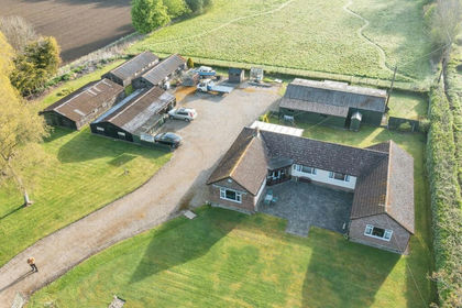
- Price
- Offers Over£600,000
- Size
- 1.5 acres
Worlingworth, Woodbridge, Suffolk, IP13, Worlingworth, Suffolk IP13 England
Added on 27/08/2026House with Land
- Price
- Guide Price£775,000
- Size
- 2 acres
Curlew Green, Kelsale, Saxmundham, Kelsale cum Carlton, Suffolk IP17 England
Added on 10/07/2026Cottage