Spithandle Lane, Wiston, BN44
- Land size
- 32 acres
- Bedrooms
- 4
- Bathrooms
- 2
Key Features
- Sensational setting
- Views to The South Downs
- Grade II listed farmhouse in the middle of the farm
- Long private drive
- Part converted brick barn with planning permission as a separate dwelling
- Extensive modern and traditional farm buildings with potential for alternative uses
- About 32 acres
- Further land available by separate negotiation
Description
The farmhouse and farm buildings are approached via a long private driveway from a quiet country lane. This property offers a level of privacy and tranquility that is hard to find in southeast England.
The main house is a traditional period Sussex farmhouse, Grade II listed with half tile-hung elevations, and facing south to the rear where there are also some of the best and most distant views over the grounds and to The South Downs in the distance.
The ground floor consists of 4 reception rooms together with kitchen/breakfast room, Utility and dog room. The fitted kitchen features an Aga and a larder. There are 4 double bedrooms and 2 bathrooms upstairs accessed via two separate staircases, one to the main ensuite bedroom, and one to the 3 further bedrooms and family bath and shower room. There are attractive oak beams to the ground floor, with a fireplace with log-burning stove and French doors out to the garden from the sitting room.
Outside
The Farm Barn is a substantial detached building to the north of the farmhouse. This barn has planning permission for a separate dwelling and has been partially converted already (Horsham District Council planning reference AH/8/99). Extending to nearly 3000 sq ft the accommodation has been left open-plan so that a new owner can design the interior to their own specification. It can be accessed independently from the driveway and would lend itself to extended family living or as a lettings opportunity.
The farm is approach via a long private drive passing through fenced grass farmland. The farmhouse gardens are a lovely feature, simple in design with shrub and flower borders around the patio. The lawns lead down to a ha-ha drawing the eye to uninterrupted views. At the bottom of the garden there is an orchard with traditional varieties of apple and plum and there is a productive kitchen garden.
Nearby, there is a detached brick and tile former dairy building with 3 old cattle stalls. This building would lend itself to alternative ancillary uses to the farmhouse.
Beyond the house and barn to the north east there are a pair of adjoining single-span Atcost livestock barns. There is a former milking parlour and dairy withing one of the buildings and a feed store area. In total these buildings extend to approximately 11,324 sq ft (1052 sq m), and to the east lies a large area of concrete hard standing and cattle handling area.
Away fro the core of the farm, towards the eastern boundary, there is a traditional timber framed barn with double doors to the front and rear. Subject to planning permission, the farm buildings are considered to have significant potential for alternative uses.
The land is entirely down to grass and has a wonderful parkland feel to it. Whilst not organic, the farming ethos has been low input for many years allowing a healthy sward across the farm.
Situation
Located in an idyllic rural setting just to the north of Steyning. This old market town has a wide range of traditional local shops, trades and services and also boasts a health and leisure centre with a swimming pool and other community facilities with schools for all age groups and churches of most denominations.
Shoreham-by-Sea, approx. 9.5 miles to the South-East has a main line railway station (with services along the South Coast to Gatwick and London Victoria) a small airport and a harbour. The city of Brighton with its excellent range of facilities is approx. 5 miles to the East of Shoreham whilst Worthing is a similar distance West. Sporting and Recreation centres are numerous and include: Racing at Goodwood, Fontwell, Brighton, Plumpton and Lingfield. Golf at Albourne, Pyecombe, Devils Dyke, Worthing, Horsham, West Chiltington & Pulborough. Polo at Cowdray Park and Knepp Castle. Equestrian events at Ardingly, Warnham & Hickstead. Sailing at Chichester, Shoreham-by-Sea and Brighton Marina. Theatre at Brighton and Chichester. Opera at Glyndebourne.
Property Ref Number:
HAM-62750Additional Information
Local Authority: Horsham District Council.
Council Tax: Band F
Services: Mains electricity and water, oil-fired central heating and hot water, drainage to a private treatment plant.
Map Location
Property details
- Tenure
- Freehold
- Council Tax Band
- F
- Date Posted
- 2026-05-20
Market Value Analysis
Compared with 34 Farms & Smallholdings listings in South East England (25+ acres).
Energy Performance Certificate
Energy Efficiency Rating
Based on UK Energy Performance Certificate standards (EU Directive 2002/91/EC)
Running costs are one side. Planning activity, flood history and ground risks for this location are in the full report.
Utilities & Restrictions
Utilities
- Electricity
- Ask Agent
- Water
- Ask Agent
- Heating
- Ask Agent
- Broadband
- Ask Agent
- Sewerage
- Ask Agent
Rights & Restrictions
- Public Rights of Way
- Ask Agent
- Private Rights of Way
- Ask Agent
- Listed Property
- Ask Agent
- Restrictions
- Ask Agent
Listed status, conservation areas and planning constraints for this location are in the full report.
Property Features
- Accessibility
- Ask Agent
- Parking
- Parking Available
- Garden
- Garden
Beyond the particulars: planning activity, flood history, heritage and ground risks, checked for this exact spot.
Connectivity
Broadband
Fastest speed available at this postcode
12 Mbps
Standard (10-30 Mbps)
Suitable for
- Web & social
- Music streaming
- Standard video calls
Mobile signal
Outdoor predictions; indoor signal depends on building materials.
Ofcom Connected Nations postcode-level predictions. Speeds and signal are modelled, not measured, and vary between addresses and providers.
Signal is the easy part. Planning activity, flood history and protected designations here are in the full report.
Nearest Schools
Primary
- Ashurst CofE Primary School1.1 milesOfsted: Good *
- Ages
- 4 to 11
- Pupils
- 48
- Type
- Voluntary aided school
- Faith
- Church of England
- Steyning CofE Primary School1.7 milesNo Ofsted rating
- Ages
- 4 to 11
- Pupils
- 335
- Type
- Voluntary controlled school
- Faith
- Church of England
- Ashington CofE Primary School2.6 milesNo Ofsted rating
- Ages
- 4 to 11
- Pupils
- 190
- Type
- Voluntary controlled school
- Faith
- Church of England
- Upper Beeding Primary School2.8 milesOfsted: Good *
- Ages
- 4 to 11
- Pupils
- 298
- Type
- Community school
- St Peter's CofE Primary School2.9 milesOfsted: Good
- Ages
- 4 to 11
- Pupils
- 354
- Type
- Academy converter
- Faith
- Church of England
Secondary
- Steyning Grammar School1.7 milesOfsted report card · Mar 2026
- Ages
- 11 to 18
- Pupils
- 1,775
- Type
- Academy converter
- Faith
- Church of England
- The Sir Robert Woodard Academy5.7 milesOfsted report card · Jan 2026
- Ages
- 11 to 18
- Pupils
- 1,427
- Type
- Academy sponsor led
- Faith
- Christian
- Bohunt School Worthing6.6 milesNo Ofsted rating
- Ages
- 11 to 16
- Pupils
- 900
- Type
- Academy sponsor led
- St Andrew's CofE High School6.7 milesOfsted: Good
- Ages
- 11 to 16
- Pupils
- 780
- Type
- Voluntary aided school
- Faith
- Church of England
- Worthing High School6.7 milesNo Ofsted rating
- Ages
- 11 to 16
- Pupils
- 1,050
- Type
- Academy converter
* Latest graded judgement covers quality of education only; no overall grade was issued under the 2024-25 inspection framework.
Distances are straight-line from the advertised location. Source: the national school registers (DfE, Welsh Government, Scottish Government) and Ofsted.
Schools are just the start: sold prices nearby, planning activity and any flood history are in the full report.
Amenities
Supermarket
GP surgery
Pharmacy
Hospital
Straight-line distances from the advertised location. Sources: NHS records, Geolytix supermarket locations, OS Open Greenspace and the national trails registers.
The area stacks up? Now check the location itself: planning nearby, protected designations and past flooding.
Getting Around
Nearest station
Nearest bus stop
Typical drive times
Straight-line distances from the advertised location; drive times are typical free-flow times over OpenStreetMap road data, so allow more at peak. Public transport locations from DfT NaPTAN.
Easy to reach matters. So do planning activity, flood history and ground risks: all in the full report.
Flood Risk
From Environment Agency flood map open data, checked around the advertised map pin and allowing for the listed acreage where known. This summary comes from LandSale, the advertising platform, not from the listing agent, and is not part of the agent's particulars. Risk can vary across a single holding, so verify anything critical through your own searches before committing.
Rivers and the sea
Surface water
Mapped within the area searched, not at the advertised map pin itself.
The detail behind these bandings
The full report pinpoints where this location sits on the flood maps, and runs the deeper checks that usually only surface after an offer.
- Exact flood zones & annual chances (included in the full report)
- Any recorded past flooding (included in the full report)
- Planning activity nearby (included in the full report)
- Heritage & conservation (included in the full report)
- Protected nature designations (included in the full report)
- Ground risks (included in the full report)
- Sold prices nearby (included in the full report)
£14.99 · one-off purchase
By LandSale, the platform. Not provided by the listing agent. Ready in about a minute.
Important notice: Information, maps and tags on this page are drawn from the advertising agent's marketing materials or generated automatically. LandSale has not verified them. Relying on these details is at your own risk, always carry out independent checks before committing to a purchase.
LandSale full disclaimer
Marketing information only - not formal particulars. The details on this website are provided for general guidance and do not constitute an offer or contract. Neither LandSale nor the advertising estate/land agent accepts responsibility for any inaccuracy.
1. Source of information
- Listing content: Core description, asking price, tenure, measurements, photographs and planning history originate from the marketing materials of the advertising estate or land agent. LandSale does not author this content and cannot guarantee its accuracy.
- Automated tags & categorisation: Property type, land-use class, acreage bands and similar labels may be applied by machine-learning models. They are intended as a helpful guide only and may not reflect the property's legal status or permitted use.
- Third-party & enriched data layers: Maps, boundary outlines, planning designations, soil reports, broadband coverage and other environmental or location-based insights are licensed from external suppliers. Such data are supplied “as is", may be incomplete or out of date and are subject to change without notice.
2. Verification required
Prospective purchasers must verify critical matters, including but not limited to planning permission, title boundaries, public rights of way, environmental constraints, acreage, services, access and VAT status, through their own inspections, specialist surveys, legal advisers and the selling agent before relying on the information or entering into any contract.
3. No warranty or liability
LandSale gives no warranty, express or implied, as to the accuracy, completeness or fitness for any particular purpose of the information displayed. LandSale shall not be liable for any loss, damage, cost or expense arising directly or indirectly from any use of or reliance on such information, save where liability may not be excluded by law.
4. Updates & feedback
If you believe any detail on this listing is inaccurate, please let us know. We will investigate and, where appropriate, update the listing or notify the agent.
© LandSale | Version 1.3 - August 2026
Listing agent
Hamptons, Horsham
64 West Street, Horsham RH12 1PL
Similar properties for sale
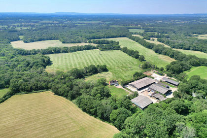
- Price
- Guide Price£4,000,000
- Size
- 375.7 acres
Billingshurst, West Sussex RH14, Billingshurst, West Sussex RH14 England
Added on 30/07/2026Farm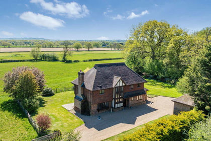
- Price
- £2,350,000
- Size
- 112.91 acres
Added on 21/07/2026Farm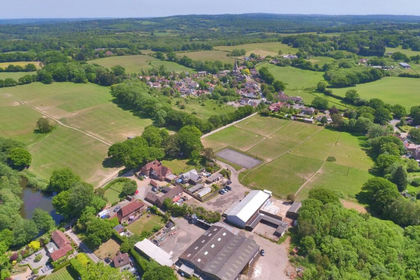
- Price
- Guide Price£4,000,000
- Size
- 433 acres
Catsfield, Battle, East Sussex, TN33, Catsfield, East Sussex TN33 England
Added on 19/03/2026Country Estate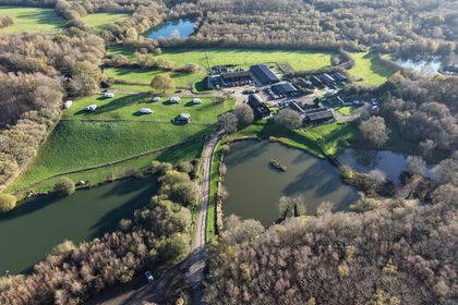
- Price
- Guide Price£3,950,000
- Size
- 50 acres
Powdermill Lane, Battle, East Sussex, TN33, Catsfield, East Sussex TN33 England
Added on 29/01/2026Fishery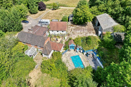
- Price
- £2,000,000
- Size
- 80 acres
Powdermill Lane, Battle, TN33, Battle, East Sussex TN33 England
Added on 14/08/2026Farm
- Price
- Guide Price£1,850,000
- Size
- 13.08 acres
Added on 17/06/2026Farm
- Price
- Guide Price£3,050,000
- Size
- 67.17 acres
Added on 13/06/2026Farm
- Price
- Guide Price£2,000,000
- Size
- 12.28 acres
Long Acres Farm, Wangfield Lane, Curdridge, Southampton, Curdridge, Hampshire SO32 England
Added on 01/07/2026Farm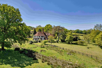
- Price
- Guide Price£2,500,000
- Size
- 71.3 acres
Conster Manor, Broad Oak, Nr Rye, Brede, East Sussex TN31 England
Added on 29/01/2026Estate
- Price
- £2,500,000
- Size
- 6 acres
Broadwater Road, West Malling, Kent, ME19, East Malling and Larkfield, Kent ME19 England
Added on 09/06/2026Smallholding