Llanddarog, Carmarthen, SA32
- Land size
- 4 acres
Key Features
- Opportunity Not to be Missed
- Prime Postcode Location - Llanddarog Village
- Site Reference Suv19/h2 allocated for minimum 10 houses with scope for greater density
- Flexible proposals welcome and joint ventures considered
- Over 4 Acres of Land
Description
Expressions of interest required for a development partner for the delivery of this prime development site. Part of the Lan currently within LDP and whole land within emerging LDP- Carmarthenshire County Council LDP - Site Reference Suv19/h2 allocated for minimum 10 houses with scope for greater density.
****** Rare Open Market Opportunity ********
Flexible proposals welcome and joint ventures considered. Site access from the Llanddarog to Porthyrhyd B4310 Road. Mature boundaries both to open field & other mature current housing developments within the village.
Superb location 8 miles from the M 4 motorway. The village is famed for its Thatched Roof Pub and other eateries. Short walk to ever popular and renowned village school, 2025 built new village hall and shop. County town of Carmarthen 6 miles and Cross Hands 3 Miles.
Directions : From Carmarthen take the A 48 east towards Cross Hands and Swansea. After 5 miles turn right towards Llanddarog. Continue to the village and pass the White Hart Public House and church on the left. After 100 yards the land will be found on the right hand side just before the school.
What3words Location. visions.poetry.squashes
General
The proposed LDP allocation site measures circa 2.25 acres (gross) in all with the option of entering into an agreement to promote the additional land identified in blue on the attached plan. The total land potential is 4 acres.
Comprising a garden area to the front and fronting the B4310 road and behind is a field currently utilised for agricultural use. Please note the site is owned by two different owners. Both parties working together to bring the site to market.
The land is relatively level with excellent road frontage and visibility in all directions.
Location
A sought after locaction and post mark. The village is well known for the Thatched Roof Public House restaurant and brewery set in a commanding location within the village. Other well established eatery of The Butchers Arms, Prince of Wales and Abadam Arms are nearby. . A new village hall is the hub of the community and gives a strong connection and meeting place for the local and wider community. Village shop and also a junior school is a stones throw from the site. The County Town of Carmarthen is 6 miles with schools, shops, Lyric Cinema & theatre, bus and rail stations, leisure centre, Dyfed Powys Police Headquarters, Egin/ S4C TV centre, West Wales General Hospital Etc. National Botanic Gardens of Wales is 2 miles. Aberglasney Gardens and Ffoslas Horse Racing Course are an easy commute. City of Swansea is 25 miles with Cardiff 65 miles approx. Easy access west to Tenby and other popular coastline destinations via the A 48 dual carriageway. Pembrey Country Park with dry ski slo...
PLANNING
There is no planning permission currently on the land. .
The land included comes under Carmarthenshire County Council LDP under reference Suv19/h2. The LDP allocates the land for a minimum 10 houses but submissions through the LDP process indicate a density of at least 15 houses.
No planning is currently available on the site, with the vendors seeking a development partner to bring forward this scheme on a subject to planning basis.
Interested parties should contact Carmarthenshire County Council Planning Department for further information Tel .
Terms
Expression of interest are invited with the proposals at this stage.
Should there be sufficient interest in the land, the vendors reserve the right to seek best offers via the route of informal tender/best bids.
Money Laundering
The successful Purchaser will be required to produce adequate identification to prove their identity within the terms of the Money Laundering Regulations. Appropriate examples include Passport/Photo Driving License and a Credas AML check. Proof of funds will also be required or mortgage in principle papers if a mortgage is required.
Services
Mains water, electric and drains services within Llanddarog village and adjacent to the site. Prospective purchasers should make their own enquiries regarding connection costs.
Map Location
Property details
- Tenure
- Ask Agent
- Council Tax Band
- Ask Agent
- Date Posted
- 2026-05-01
Market Value Analysis
Compared with 90 Development Land listings in Wales (1+ acres).
Utilities & Restrictions
Utilities
- Electricity
- Ask Agent
- Water
- Ask Agent
- Heating
- Ask Agent
- Broadband
- Ask Agent
- Sewerage
- Ask Agent
Rights & Restrictions
- Public Rights of Way
- Ask Agent
- Private Rights of Way
- Ask Agent
- Listed Property
- Ask Agent
- Restrictions
- Ask Agent
Listed status, conservation areas and planning constraints for this location are in the full report.
Property Features
- Accessibility
- Ask Agent
- Parking
- Ask Agent
- Garden
- Garden
Beyond the particulars: planning activity, flood history, heritage and ground risks, checked for this exact spot.
Connectivity
Broadband
Fastest speed available at this postcode
80 Mbps
Superfast
Suitable for
- HD streaming
- Video calls
- Web & social
Mobile signal
Predicted 4G and 5G signal; indoor signal depends on building materials.
Ofcom Connected Nations postcode-level predictions. Speeds and signal are modelled, not measured, and vary between addresses and providers.
Signal is the easy part. Planning activity, flood history and protected designations here are in the full report.
Nearest Schools
Primary
- Llanddarog80 metres
- Pupils
- 69
- Type
- Nursery, Infants & Juniors
- Language
- Welsh medium school / provision (including transitional)
- Ysgol Gynradd Gymraeg Drefach2.5 miles
- Pupils
- 45
- Type
- Nursery, Infants & Juniors
- Language
- Welsh medium school / provision (including transitional)
- Bancffosfelen2.8 miles
- Pupils
- 54
- Type
- Nursery, Infants & Juniors
- Language
- Welsh medium school / provision (including transitional)
- Nantgaredig3.2 miles
- Pupils
- 233
- Type
- Nursery, Infants & Juniors
- Language
- Welsh medium school / provision (including transitional)
- Ysgol Gynradd Pontyberem3.3 miles
- Pupils
- 227
- Type
- Nursery, Infants & Juniors
- Language
- Welsh medium school / provision (including transitional)
Secondary
- Ysgol Maes Y Gwendraeth3.8 miles
- Pupils
- 1,084
- Type
- Secondary (ages 11-19)
- Language
- Welsh medium school / provision (including transitional)
- Ysgol Gyfun Gymraeg Bro Myrddin5.9 miles
- Pupils
- 929
- Type
- Secondary (ages 11-19)
- Language
- Welsh medium school / provision (including transitional)
- Queen Elizabeth High School6.5 miles
- Pupils
- 1,289
- Type
- Secondary (ages 11-19)
- Language
- English medium school / provision
- Ysgol Bro Dinefwr8.1 miles
- Pupils
- 1,092
- Type
- Secondary (ages 11-19)
- Language
- Dual language school / provision (Welsh and English) (including transitional)
- Ysgol Dyffryn Aman8.2 miles
- Pupils
- 1,547
- Type
- Secondary (ages 11-19)
- Language
- Dual language school / provision (Welsh and English) (including transitional)
Distances are straight-line from the advertised location. Source: the national school registers (DfE, Welsh Government, Scottish Government) and Ofsted.
Schools are just the start: sold prices nearby, planning activity and any flood history are in the full report.
Amenities
Supermarket
GP surgery
Pharmacy
Straight-line distances from the advertised location. Sources: NHS records, Geolytix supermarket locations, OS Open Greenspace and the national trails registers.
The area stacks up? Now check the location itself: planning nearby, protected designations and past flooding.
Getting Around
Nearest station
Nearest bus stop
Typical drive times
Straight-line distances from the advertised location; drive times are typical free-flow times over OpenStreetMap road data, so allow more at peak. Public transport locations from DfT NaPTAN.
Easy to reach matters. So do planning activity, flood history and ground risks: all in the full report.
Flood Risk
Natural Resources Wales open data, checked around the advertised map pin for the listed acreage. Long-term risk counts flood defences; the planning map's flood zones do not. Provided by LandSale, not the listing agent, and not part of the agent's particulars. Risk varies across a holding, so verify before committing.
Rivers and the sea
Planning map: Flood Zone 1.
Surface water
These bandings are the summary. Where this location sits on the flood maps, plus planning activity, heritage and ground risks, is in the full report.
Important notice: Information, maps and tags on this page are drawn from the advertising agent's marketing materials or generated automatically. LandSale has not verified them. Relying on these details is at your own risk, always carry out independent checks before committing to a purchase.
LandSale full disclaimer
Marketing information only - not formal particulars. The details on this website are provided for general guidance and do not constitute an offer or contract. Neither LandSale nor the advertising estate/land agent accepts responsibility for any inaccuracy.
1. Source of information
- Listing content: Core description, asking price, tenure, measurements, photographs and planning history originate from the marketing materials of the advertising estate or land agent. LandSale does not author this content and cannot guarantee its accuracy.
- Automated tags & categorisation: Property type, land-use class, acreage bands and similar labels may be applied by machine-learning models. They are intended as a helpful guide only and may not reflect the property's legal status or permitted use.
- Third-party & enriched data layers: Maps, boundary outlines, planning designations, soil reports, broadband coverage and other environmental or location-based insights are licensed from external suppliers. Such data are supplied “as is", may be incomplete or out of date and are subject to change without notice.
2. Verification required
Prospective purchasers must verify critical matters, including but not limited to planning permission, title boundaries, public rights of way, environmental constraints, acreage, services, access and VAT status, through their own inspections, specialist surveys, legal advisers and the selling agent before relying on the information or entering into any contract.
3. No warranty or liability
LandSale gives no warranty, express or implied, as to the accuracy, completeness or fitness for any particular purpose of the information displayed. LandSale shall not be liable for any loss, damage, cost or expense arising directly or indirectly from any use of or reliance on such information, save where liability may not be excluded by law.
4. Updates & feedback
If you believe any detail on this listing is inaccurate, please let us know. We will investigate and, where appropriate, update the listing or notify the agent.
© LandSale | Version 1.3 - August 2026
Similar properties for sale
- Price
- Guide Price£300,000
- Size
- 85.62 acres
Trap, Llandeilo, SA18, Llandeilo, Carmarthenshire SA18 Wales
Added on 07/08/2026Smallholding
- Price
- Guide Price£300,000
- Size
- 24.27 acres
Land & Buildings at Craig Yr Odyn, Trap, Llandeilo, SA19, Llandeilo, Carmarthenshire SA19 Wales
Added on 13/07/2026Smallholding
- Price
- Guide Price£400,000
Cwmifor, Llandeilo, SA19, Manordeilo and Salem, Carmarthenshire SA19 Wales
Added on 25/07/2026Development Land
- Price
- Guide Price£475,000
- Size
- 69 acres
Added on 24/09/2026Smallholding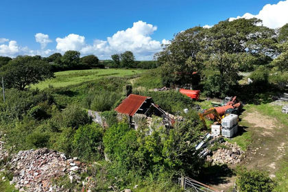
- Price
- Offers in Region of£499,995
- Size
- 5.6 acres
Added on 20/02/2026Building Plot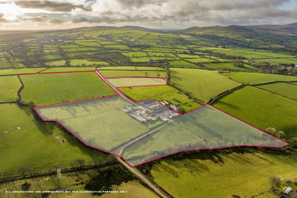
- Price
- £300,000
- Size
- 17.72 acres
Added on 29/01/2026Smallholding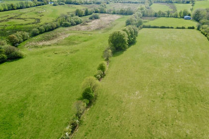
- Price
- Guide Price£350,000
- Size
- 77 acres
Llanio Road, Tregaron, Llanddewi Brefi, Ceredigion SY25 Wales
Added on 30/05/2026Farm Added on 29/01/2026Development Land
- Price
- Offers Over£325,000
Storws Fawr, Drury Lane, Aberaeron, SA46, Aberaeron, Ceredigion SA46 Wales
Added on 20/08/2026Development Land
- Price
- Offers in Region of£325,000
- Size
- 1.3 acres
The Old Granary, Farm Road, Aberman, Aberdare, Aberaman South, Rhondda Cynon Taf CF44 Wales
Added on 29/01/2026Development Land