Soulton Road, Wem, Shrewsbury.
- Land size
- 12 acres
- Bedrooms
- 6
- Bathrooms
- 1
Key Features
- Substantial 2,500 + sq ft Farmhouse
- Scope to extend and Modernise
- Range of over 11,000 sq ft Traditional Outbuildings
- Land and Gardens ext to approx. 12 acres
- Edge of Town Location
Description
A substantial period farmhouse offering in excess of 2,500 sq ft of spacious living accommodation, alongside a range of traditional agricultural buildings and land and gardens which extend to around 12 acres, situated in a peaceful yet convenient position on the edge of the market town of Wem.
Description - Halls are delighted with instructions to offer Brook Farm in Wem for sale by private treaty.
Brook Farm comprises a substantial period farmhouse offering in excess of 2,500 sq ft of spacious living accommodation, alongside a range of traditional agricultural buildings and land and gardens which extend to around 12ac.
The property is presently utilised as a compact dairy farm but offers excellent potential to become a substantial country residence with equestrian facilities. The range of buildings and excellent road connections offer further scope for the property to serve a variety of commercial usages (LA consent permitting).
Situation - Brook Farm occupies a convenient yet private position on the edge of the historic market town of Wem, with the noted landscape of the north Shropshire countryside positioned to the east and the town’s many amenities close at hand to the west, these including Schools, Supermarkets, Train Station, Public Houses, Restaurants, and Medical Facilities; with the county town of Shrewsbury lying around 11 miles to the south and providing a wider range of facilities, including leisure and cultural attractions.
The nearby A49 connects the property to the wider area, with Wem Train Station providing rail links to further afield.
W3w - unguarded.swift.splits
Schooling - Within a short drive are a number of highly rated state and private schools including The Thomas Adams School, St. Peter’s C of E Primary, Lakelands Academy, Newtown C of E Primary, Ellesmere College, Shrewsbury School, Shrewsbury High School, Moreton Hall, The Priory, Prestefelde Prep., Packwood Haugh, and Adcote School for Girls.
Directions - Leave Shrewsbury to the north via the A528, continuing for around 8 miles and keeping right at the village of Harmer Hill as the road merges into the B5476. At a T-junction in the centre of Wem, turn right onto Aston St and over the train tracks onto Soulton Rd, where around 1.6 miles later, the property is positioned on the right.
The Property - Brook Farm centres around a substantial 4/6 Bedroom period farmhouse which provides over 2,500 sq ft of well proportioned living accommodation arranged across three floors, all of which now offers excellent potential for modernisation and improvement.
Situated immediately to the south-east of the dwelling are a connected range of traditional brick-built agricultural buildings which could (LA consent permitting) serve as an extension to the living accommodation.
The ground floor of the property is typical of the era and boasts a range of comfortably sized reception rooms ideally suited to families, these presently utilised as a Sitting Room, Dining Room, and general Reception Room, whilst being joined by a Kitchen and a useful Utility.
A passageway leads from the back door to an external store and on to a connecting range of traditional buildings.
The upper floors continue to offer impressively proportioned rooms, with the first floor featuring four generous Bedroom served by a family Bathroom.
The second floor is, as yet, undeveloped but boasts three individual rooms, one of which centrally connects, which could readily provide a further 2/3 Bedrooms and, potentially, bathrooms/en-suites.
Outside - Brook Farm extends, in all, to around 12 acres and is presently utilised as a compact dairy farm, with an abreast milking parlour and bulk tank in situ, allowing for a continuation of the current farming enterprise.
A range of traditional buildings extending to around 11,000 sq ft are positioned around a central courtyard and offer excellent potential for a variety of further usages, be they equestrian or agricultural in nature or, potentially, for residential conversion (LA consent permitting).
Positioned to the west of the homestead are predominately lawned gardens and ample driveway parking, which overlook an attractive natural pond and an element of the land beyond.
The land is broadly flat and predominately situated to the south and east of the property. Aside from agricultural pursuits, the land would be ideally suited to those with equestrian interests and may offer scope for further development in this arena (LA consent permitting).
Services - We understand that the property has the benefit of mains water and electric. Drainage is provided to a private system
Tenure - The property is said to be of Freehold tenure and vacant possession will be granted upon completion.
Local Authority - Shropshire Council, Shirehall, Abbey Foregate, Shrewsbury, Shropshire, SY2 6ND.
Council Tax - The property is shown as being within Council Tax band F on the local authority register.
Anti-Money Laundering (Aml) Checks - We are legally obligated to undertake anti-money laundering checks on all property purchasers. Whilst we are responsible for ensuring that these checks, and any ongoing monitoring, are conducted properly; the initial checks will be handled on our behalf by a specialist company, Movebutler, who will reach out to you once your offer has been accepted.
The charge for these checks is £30 (including VAT) per purchaser, which covers the necessary data collection and any manual checks or monitoring that may be required. This cost must be paid in advance, directly to Movebutler, before a memorandum of sale can be issued, and is non-refundable. We thank you for your cooperation.
Viewings - Strictly by appointment through Halls, The Square, Ellesmere, Shropshire. Tel: .
Map Location
Property details
- Tenure
- Freehold
- Council Tax Band
- F
- Date Posted
- 2026-04-24
Market Value Analysis
Compared with 118 Homes with Land listings in West Midlands (10+ acres).
Energy Performance Certificate
Energy Efficiency Rating
Based on UK Energy Performance Certificate standards (EU Directive 2002/91/EC)
Running costs are one side. Planning activity, flood history and ground risks for this location are in the full report.
Utilities & Restrictions
Utilities
- Electricity
- Ask Agent
- Water
- Ask Agent
- Heating
- Ask Agent
- Broadband
- Ask Agent
- Sewerage
- Ask Agent
Rights & Restrictions
- Public Rights of Way
- Ask Agent
- Private Rights of Way
- Ask Agent
- Listed Property
- Ask Agent
- Restrictions
- Ask Agent
Listed status, conservation areas and planning constraints for this location are in the full report.
Property Features
- Accessibility
- Ask Agent
- Parking
- Parking Available
- Garden
- Garden
Beyond the particulars: planning activity, flood history, heritage and ground risks, checked for this exact spot.
Connectivity
Broadband
Fastest speed available at this postcode
1.8 Gbps
Gigabit full fibre
Suitable for
- 4K streaming on every screen
- Full-time home working
- Online gaming & big downloads
Fixed wireless access may also be an option here.
Mobile signal
Outdoor predictions; indoor signal depends on building materials.
Ofcom Connected Nations postcode-level predictions. Speeds and signal are modelled, not measured, and vary between addresses and providers.
Signal is the easy part. Planning activity, flood history and protected designations here are in the full report.
Nearest Schools
Primary
- St Peter's CofE Primary School1 mileOfsted: Good
- Ages
- 2 to 11
- Pupils
- 404
- Type
- Academy converter
- Faith
- Church of England
- Prees CofE Primary School2.8 milesNo Ofsted rating
- Ages
- 2 to 11
- Pupils
- 194
- Type
- Academy converter
- Faith
- Church of England
- Lower Heath CofE Primary School3.3 milesOfsted: Good
- Ages
- 2 to 11
- Pupils
- 105
- Type
- Academy converter
- Faith
- Church of England
- Newtown CofE Primary School3.4 milesOfsted: Good *
- Ages
- 3 to 11
- Pupils
- 86
- Type
- Voluntary controlled school
- Faith
- Church of England
- Whixall CofE Primary School3.6 milesOfsted: Good *
- Ages
- 2 to 11
- Pupils
- 152
- Type
- Academy converter
- Faith
- Church of England
Secondary
- The Thomas Adams School1.3 milesOfsted: Good
- Ages
- 11 to 18
- Pupils
- 1,214
- Type
- Academy converter
- Sir John Talbot's School6.6 milesOfsted: Good
- Ages
- 11 to 19
- Pupils
- 861
- Type
- Academy sponsor led
- The Corbet School8 milesNo Ofsted rating
- Ages
- 11 to 16
- Pupils
- 691
- Type
- Academy converter
- Lakelands Academy8.9 milesOfsted report card · Jun 2026
- Ages
- 11 to 16
- Pupils
- 590
- Type
- Academy converter
- Shrewsbury Academy9.2 milesOfsted: Requires improvement
- Ages
- 11 to 16
- Pupils
- 817
- Type
- Academy converter
* Latest graded judgement covers quality of education only; no overall grade was issued under the 2024-25 inspection framework.
Distances are straight-line from the advertised location. Source: the national school registers (DfE, Welsh Government, Scottish Government) and Ofsted.
Schools are just the start: sold prices nearby, planning activity and any flood history are in the full report.
Amenities
Supermarket
GP surgery
Pharmacy
Hospital
Green space
Straight-line distances from the advertised location. Sources: NHS records, Geolytix supermarket locations, OS Open Greenspace and the national trails registers.
The area stacks up? Now check the location itself: planning nearby, protected designations and past flooding.
Getting Around
Nearest station
Nearest bus stop
Typical drive times
Straight-line distances from the advertised location; drive times are typical free-flow times over OpenStreetMap road data, so allow more at peak. Public transport locations from DfT NaPTAN.
Easy to reach matters. So do planning activity, flood history and ground risks: all in the full report.
Flood Risk
From Environment Agency flood map open data, checked around the advertised map pin and allowing for the listed acreage where known. This summary comes from LandSale, the advertising platform, not from the listing agent, and is not part of the agent's particulars. Risk can vary across a single holding, so verify anything critical through your own searches before committing.
Rivers and the sea
Mapped within the area searched, not at the advertised map pin itself.
Surface water
Mapped within the area searched, not at the advertised map pin itself.
The detail behind these bandings
The full report pinpoints where this location sits on the flood maps, and runs the deeper checks that usually only surface after an offer.
- Exact flood zones & annual chances (included in the full report)
- Any recorded past flooding (included in the full report)
- Planning activity nearby (included in the full report)
- Heritage & conservation (included in the full report)
- Protected nature designations (included in the full report)
- Ground risks (included in the full report)
- Sold prices nearby (included in the full report)
£14.99 · one-off purchase
By LandSale, the platform. Not provided by the listing agent. Ready in about a minute.
Important notice: Information, maps and tags on this page are drawn from the advertising agent's marketing materials or generated automatically. LandSale has not verified them. Relying on these details is at your own risk, always carry out independent checks before committing to a purchase.
LandSale full disclaimer
Marketing information only - not formal particulars. The details on this website are provided for general guidance and do not constitute an offer or contract. Neither LandSale nor the advertising estate/land agent accepts responsibility for any inaccuracy.
1. Source of information
- Listing content: Core description, asking price, tenure, measurements, photographs and planning history originate from the marketing materials of the advertising estate or land agent. LandSale does not author this content and cannot guarantee its accuracy.
- Automated tags & categorisation: Property type, land-use class, acreage bands and similar labels may be applied by machine-learning models. They are intended as a helpful guide only and may not reflect the property's legal status or permitted use.
- Third-party & enriched data layers: Maps, boundary outlines, planning designations, soil reports, broadband coverage and other environmental or location-based insights are licensed from external suppliers. Such data are supplied “as is", may be incomplete or out of date and are subject to change without notice.
2. Verification required
Prospective purchasers must verify critical matters, including but not limited to planning permission, title boundaries, public rights of way, environmental constraints, acreage, services, access and VAT status, through their own inspections, specialist surveys, legal advisers and the selling agent before relying on the information or entering into any contract.
3. No warranty or liability
LandSale gives no warranty, express or implied, as to the accuracy, completeness or fitness for any particular purpose of the information displayed. LandSale shall not be liable for any loss, damage, cost or expense arising directly or indirectly from any use of or reliance on such information, save where liability may not be excluded by law.
4. Updates & feedback
If you believe any detail on this listing is inaccurate, please let us know. We will investigate and, where appropriate, update the listing or notify the agent.
© LandSale | Version 1.3 - August 2026

Listing agent
Halls Estate Agents, Ellesmere
The Square, Cross Street, Ellesmere, SY12 0AW
Contact Halls Estate Agents, Ellesmere
The Square, Cross Street, Ellesmere, SY12 0AW
View agent profileSimilar properties for sale
- Price
- Offers Over£700,000
- Size
- 45 acres
Horseshoe Pass, Llangollen, Llantysilio, Denbighshire LL20 Wales
Added on 29/01/2026Smallholding
- Price
- Offers Over£750,000
- Size
- 20.31 acres
Wallmires Lane, Werrington, Stoke-On-Trent, Werrington, Staffordshire ST9 England
Added on 29/01/2026Farmhouse
- Price
- £775,000
- Size
- 27 acres
Castle Caereinion, Welshpool, Powys, Castle Caereinion, Powys SY21 Wales
Added on 08/07/2026Smallholding
- Price
- Guide Price£700,000
- Size
- 22.44 acres
Covert Lane, Chelmarsh, Bridgnorth, Chelmarsh, Shropshire WV16 England
Added on 26/08/2026Smallholding
- Price
- Offers in Region of£750,000
- Size
- 53.32 acres
Hirnant, Penybontfawr, Oswestry, Pen-y-Bont-Fawr, Powys SY10 Wales
Added on 09/07/2026Farm
- Price
- Guide Price£750,000
- Size
- 14.83 acres
Gelli (Lot 1), Llanfair Caereinion, Welshpool, Powys, SY21, Llanfair Caereinion, Powys SY21 Wales
Added on 29/07/2026Small Farm
- Price
- Offers in Region of£800,000
- Size
- 26 acres
Added on 13/05/2026Farm
- Price
- £750,000
- Size
- 31.8 acres
Llanwddyn, Oswestry, Powys, SY10, Llanwddyn, Powys SY10 Wales
Added on 29/01/2026Small Farm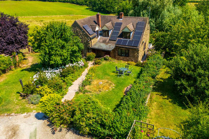
- Price
- Guide Price£825,000
- Size
- 20 acres
Neen Savage, Cleobury Mortimer, DY14, Neen Savage, Shropshire DY14 England
Added on 15/04/2026Smallholding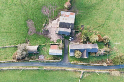
- Price
- Offers in Region of£745,000
- Size
- 22.24 acres
Bridge Flatts Farm, Winkhill, Leek, Waterhouses, Staffordshire ST13 England
Added on 21/02/2026Farmhouse