Forge House Cottage, Hollin Lane, Ripponden HX6
- Land size
- 2.5 acres
- Bedrooms
- 3
- Bathrooms
- 3
Key Features
- SEMI-DETACHED HOME WITH LAND
- RURAL LOCATION WITH SUPERB VIEWS
- TWO RECEPTION ROOMS & STUDY
- SPACIOUS FITTED DINING KITCHEN
- TWO UTILITY ROOMS
- THREE DOUBLE BEDROOMS
- BATHROOM, SHOWER ROOM & EN-SUITE SHOWER ROOM
- ESTABLISHED GARDENS & APPROX. 2.5 ACRES GRAZING LAND
- SUMMERHOUSE & TIMBER BARN
- THREE CAR GARAGING & OFF ROAD PARKING
Description
Forge House Cottage stands in a slightly elevated position off Rochdale Road, approximately 1½ miles from the village centre. This commanding position affords panoramic views over the valley and the property is surrounded by open fields and countryside.
The three bedroom / three bathroom accommodation offers a generous sized family home of individual charm and character, and is fitted to a high standard throughout.
Together with this there are good sized established gardens with summer house, three car garaging, a timber barn and approximately 2½ acres of grazing land.
GROUND FLOOR
Entrance Porch
Dining Kitchen
Conservatory
Pantry
Utility Room
Sitting Room
Study / Hallway
Shower Room
Bedroom 1
En-Suite Shower Room
FIRST FLOOR
First Floor Landing
Bedroom 2
Storage Room
Bedroom 3
Bathroom
INTERNAL
Entering Forge House Cottage via a charming porch with a composite stable-style door and stone-flagged floor. The dining kitchen boasts bespoke cream cabinetry, concealed lighting, and granite worktops incorporating a Belfast sink. It is well equipped with a blue, two-oven oil-fired Aga, integrated larder fridge, and dishwasher, while separate utility rooms provide additional units and a stainless steel sink. The conservatory is a particular delight, with French doors opening to the garden and far-reaching countryside views. The sitting room enjoys windows to three aspects, a cast iron multi-fuel stove set within a stone fireplace, and a pitched, pine-beamed ceiling. A study or inner hall, complete with wood-burning stove, leads to the staircase, and there is also a generous utility room.
On the ground floor lies a spacious double bedroom with fitted wardrobes and an en-suite shower room, alongside a further well-appointed shower room. Upstairs are two double bedrooms, one with fitted storage and access to the eaves, together with a neatly presented family bathroom.
EXTERNAL
To the front of the property is a good sized enclosed private established garden. There are several stone patio areas, lawns, flowerbeds and shrubs together with summerhouse which has light, power and a stone fireplace. Also within the enclosed garden there is a useful stone outhouse/garden store and good sized ornamental pond. To the side of the property is an enclosed garden with panoramic views over the valley, mature shrubs and trees. There is ample parking, a double and single garage, both with light, power and remote controlled up and over doors.
LAND
Together with the property there is approximately 2½ acres of grazing land and a timber steel framed barn 22’ x 20’8 (6.7 x 6.3). The barn has light, power, a roll up door and separate personal door.
LOCATION
Located within 2 miles of Ripponden village with excellent local amenities including highly regarded schooling in both the private and state sectors, health centre, dental surgery, vets’ practice, church, library, and a selection of shops, bars and restaurants.
The M62 is within 15 minutes’ drive, providing excellent commuter links to the business centres of Leeds, Bradford and Manchester and there is a mainline station in the nearby towns of Littleborough and Sowerby Bridge,
SERVICES
Mains water and electric. Oil fired heating, Worcester boiler located in utility room. Private septic tank drainage.
DIRECTIONS
From Ripponden traffic lights, take the A58 Rochdale Road uphill. Proceed ahead for approximately 1½ miles, turning right after the row of cottages and a bus shelter into Hollin Lane. Turn left after 100yds to Forge House Cottage.
IMPORTANT NOTICEThese particulars are produced in good faith, but are intended to be a general guide only and do not constitute any part of an offer or contract. No person in the employment of VG Estate Agent has any authority to make any representation of warranty whatsoever in relation to the property. Photographs are reproduced for general information only and do not imply that any item is included for sale with the property. All measurements are approximate. Sketch plan not to scale and for identification only. The placement and size of all walls, doors, windows, staircases and fixtures are only approximate and cannot be relied upon as anything other than an illustration for guidance purposes only.MONEY LAUNDERING REGULATIONS
In order to comply with the ‘Money Laundering, Terrorist Financing and Transfer of Funds (Information on the Payer) Regulations 2017’, intending purchasers will be asked to produce identification documentation and we would ask for your co-operation in order that there will be no delay in agreeing the sale.
Map Location
Property details
- Tenure
- Freehold
- Council Tax Band
- E
- Date Posted
- 2026-04-23
Market Value Analysis
Compared with 696 Homes with Land listings in Yorkshire and The Humber (1+ acres).
Utilities & Restrictions
Utilities
- Electricity
- Ask Agent
- Water
- Ask Agent
- Heating
- Ask Agent
- Broadband
- Ask Agent
- Sewerage
- Ask Agent
Rights & Restrictions
- Public Rights of Way
- Ask Agent
- Private Rights of Way
- Ask Agent
- Listed Property
- Ask Agent
- Restrictions
- Ask Agent
Listed status, conservation areas and planning constraints for this location are in the full report.
Property Features
- Accessibility
- Ask Agent
- Parking
- Parking Available
- Garden
- Garden
Beyond the particulars: planning activity, flood history, heritage and ground risks, checked for this exact spot.
Connectivity
Broadband
Fastest speed available at this postcode
1.8 Gbps
Gigabit full fibre
Suitable for
- 4K streaming on every screen
- Full-time home working
- Online gaming & big downloads
Fixed wireless access may also be an option here.
Mobile signal
Outdoor predictions; indoor signal depends on building materials.
Ofcom Connected Nations postcode-level predictions. Speeds and signal are modelled, not measured, and vary between addresses and providers.
Signal is the easy part. Planning activity, flood history and protected designations here are in the full report.
Nearest Schools
Primary
- St John's Primary School In Rishworth1 mileOfsted: Good
- Ages
- 4 to 11
- Pupils
- 152
- Type
- Academy converter
- Faith
- Church of England
- Ripponden Junior and Infant School1.5 milesNo Ofsted rating
- Ages
- 4 to 11
- Pupils
- 171
- Type
- Community school
- St Mary's CofE (VC) J and I School1.7 milesOfsted: Good
- Ages
- 4 to 11
- Pupils
- 61
- Type
- Voluntary controlled school
- Faith
- Church of England
- Barkisland CofE VA Primary School2.2 milesOfsted: Good
- Ages
- 4 to 11
- Pupils
- 197
- Type
- Voluntary aided school
- Faith
- Church of England
- Triangle CofE VC Primary School2.4 milesOfsted: Good
- Ages
- 4 to 11
- Pupils
- 173
- Type
- Voluntary controlled school
- Faith
- Church of England
Secondary
- Ryburn Valley High School2.9 milesNo Ofsted rating
- Ages
- 11 to 18
- Pupils
- 1,589
- Type
- Academy converter
- Trinity Academy Grammar4 milesOfsted: Good
- Ages
- 11 to 16
- Pupils
- 968
- Type
- Academy sponsor led
- The Calder Learning Trust4.4 milesOfsted: Good
- Ages
- 4 to 16
- Pupils
- 1,250
- Type
- Academy converter
- The Crossley Heath School4.9 milesOfsted: Good
- Ages
- 11 to 18
- Pupils
- 1,179
- Type
- Academy converter
- The Halifax Academy5 milesOfsted: Good
- Ages
- 4 to 16
- Pupils
- 1,461
- Type
- Academy converter
Distances are straight-line from the advertised location. Source: the national school registers (DfE, Welsh Government, Scottish Government) and Ofsted.
Schools are just the start: sold prices nearby, planning activity and any flood history are in the full report.
Amenities
Supermarket
GP surgery
Pharmacy
Hospital
Green space
Straight-line distances from the advertised location. Sources: NHS records, Geolytix supermarket locations, OS Open Greenspace and the national trails registers.
The area stacks up? Now check the location itself: planning nearby, protected designations and past flooding.
Getting Around
Nearest station
Nearest bus stop
Typical drive times
Straight-line distances from the advertised location; drive times are typical free-flow times over OpenStreetMap road data, so allow more at peak. Public transport locations from DfT NaPTAN.
Easy to reach matters. So do planning activity, flood history and ground risks: all in the full report.
Flood Risk
From Environment Agency flood map open data, checked around the advertised map pin and allowing for the listed acreage where known. This summary comes from LandSale, the advertising platform, not from the listing agent, and is not part of the agent's particulars. Risk can vary across a single holding, so verify anything critical through your own searches before committing.
Rivers and the sea
Surface water
These bandings are the summary. Where this location sits on the flood maps, plus planning activity, heritage and ground risks, is in the full report.
Important notice: Information, maps and tags on this page are drawn from the advertising agent's marketing materials or generated automatically. LandSale has not verified them. Relying on these details is at your own risk, always carry out independent checks before committing to a purchase.
LandSale full disclaimer
Marketing information only - not formal particulars. The details on this website are provided for general guidance and do not constitute an offer or contract. Neither LandSale nor the advertising estate/land agent accepts responsibility for any inaccuracy.
1. Source of information
- Listing content: Core description, asking price, tenure, measurements, photographs and planning history originate from the marketing materials of the advertising estate or land agent. LandSale does not author this content and cannot guarantee its accuracy.
- Automated tags & categorisation: Property type, land-use class, acreage bands and similar labels may be applied by machine-learning models. They are intended as a helpful guide only and may not reflect the property's legal status or permitted use.
- Third-party & enriched data layers: Maps, boundary outlines, planning designations, soil reports, broadband coverage and other environmental or location-based insights are licensed from external suppliers. Such data are supplied “as is", may be incomplete or out of date and are subject to change without notice.
2. Verification required
Prospective purchasers must verify critical matters, including but not limited to planning permission, title boundaries, public rights of way, environmental constraints, acreage, services, access and VAT status, through their own inspections, specialist surveys, legal advisers and the selling agent before relying on the information or entering into any contract.
3. No warranty or liability
LandSale gives no warranty, express or implied, as to the accuracy, completeness or fitness for any particular purpose of the information displayed. LandSale shall not be liable for any loss, damage, cost or expense arising directly or indirectly from any use of or reliance on such information, save where liability may not be excluded by law.
4. Updates & feedback
If you believe any detail on this listing is inaccurate, please let us know. We will investigate and, where appropriate, update the listing or notify the agent.
© LandSale | Version 1.3 - August 2026
Listing agent
V G Estate Agent, Ripponden
119A Halifax Road, Ripponden, West Yorkshire HX6 4DA
View agent profileSimilar properties for sale
- Price
- £650,000
- Size
- 2 acres
Stone Gables, Cross Wells Road, Soyland HX6, Ripponden, Calderdale HX6 England
Added on 17/06/2026Barn Conversion
- Price
- £625,000
- Size
- 2 acres
2 Helm Barn, Helm Lane, Triangle HX6, Calder Valley, Calderdale HX6 England
Added on 30/06/2026Barn Conversion
- Price
- £595,950
- Size
- 4 acres
Added on 13/06/2026House with Land
- Price
- £495,000
- Size
- 1.6 acres
46-48 Sparkhouse Lane, Norland, HX6, Calder Valley, Calderdale HX6 England
Added on 11/08/2026House with Land
- Price
- Offers Over£595,950
- Size
- 1 acres
Foster Clough, Height Road, Hebden Bridge, Hebden Royd, Calderdale HX7 England
Added on 16/09/2026Barn Conversion
- Price
- £700,000
- Size
- 1.25 acres
Great House Clough Farm, Great House Road, Todmorden OL14, Todmorden, Calderdale OL14 England
Added on 27/08/2026House with Land
- Price
- £528,000
- Size
- 3 acres
Lane Top House, Crossley New Road, Todmorden, Todmorden, Calderdale OL14 England
Added on 11/06/2026House with Land
- Price
- Offers Over£600,000
- Size
- 1.2 acres
Pinfold Lane, Fixby, Huddersfield, Calder Valley, Calderdale HD2 England
Added on 27/05/2026House with Land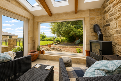
- Price
- Offers in Excess of£600,000
- Size
- 2 acres
Added on 22/07/2026Farmhouse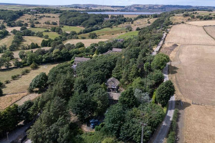
- Price
- Guide Price£590,000
- Size
- 1.2 acres
Crosland Edge, Meltham, Holmfirth, West Yorkshire, HD9, Meltham, Kirklees HD9 England
Added on 26/08/2026Cottage