St.Neot, Bodmin - Cornwall
- Land size
- 15.5 acres
- Bedrooms
- 8
- Bathrooms
- 7
Key Features
- Character Country House
- 3 popular holiday letting cottages
- Grade II Listed
- Established B&B Business
- Well Presented
- Stunning picturesque location
- Peace and tranquillity
- Landscaped gardens
- Pasture paddocks / Woodland
- River and waterfall
Description
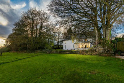
Quietly located 15.5 acre country estate in the heart of the picturesque Cornish countryside. Well presented, character 4 bedroom house, 3 cottages. Extensive lawned landscaped gardens. Pasture paddocks, amenity woodland, ponds and river.
•Character Country House
•3 popular holiday letting cottages
•Grade II Listed
•Established B&B Business
•Well Presented
•Stunning picturesque location
•Peace and tranquillity
•Landscaped gardens
•Pasture paddocks
•Woodland
•River and waterfall
Mennabroom is located on the southern edge of Bodmin Moor, 2 miles to the north of St Neot Village and 17 miles Southwest of Launceston. Liskeard is 11 miles to the southeast and Truro is 37 miles to the southwest. and Launceston. Mennabroom is situated in an excellent location being equal distance from both the north and south Cornish coasts. Bodmin Moor splits the north and south coasts and is home to the county's highest peaks, providing picturesque open spaces for those in search of the great outdoors with its mile-upon-mile of spectacular walks, cycling and horse riding.
Mennabroom has a charming and characterful Grade II listed family home dating from the 13th Century and believed to be the oldest inhabited dwelling in the area. Extensive renovations have been undertaken in recent years including re-roofing the farmhouse with reclaimed Delabole slate, installation of air source heat pumps central heating, custom-built American white oak kitchen furniture, bathroom suites and a solar PV array. The accommodation briefly comprises: entrance hall, sitting room and large drawing room with wood burning stoves, dining room, farmhouse kitchen with oil fired Aga and utility boot room. On the first floor master suite with dressing room and en-suite bathroom, 2 further en-suite double bedrooms and a nursery/study. Three 17th Century converted barns provide popular, 4 star self-catering holiday cottages and a detached studio/office reception, cloak room and laundry room offers an ideal work-from-home opportunity. A modern general purpose building offers storage and housing for livestock and potential for American Barn style stabling. A particular feature of the property are the beautiful grounds extending in all to approximately 15.5 acres (6.27 ha), of gardens and woodland, complemented by productive pasture land which provides grazing for livestock or horses. Running along the valley bottom is an area of deciduous amenity woodland intersected by the River Dewey, providing a natural conservation area and wildlife haven, together with delightful walks.
The Holiday Cottages - There are three well-presented converted barns arranged around the rear courtyard, which provide popular, spacious and well equipped holiday letting cottages:
The Byre – sleeps 2
The Shippon – Sleeps 4
The Tallett – Sleeps 6
Outside - An attractive driveway leads through the land to a large parking and turning area beyond the farmhouse. A further drive spurs off the main driveway and provides separate access to the holiday cottages and parking area. Lying to the east of the main house is a garden with a large patio, Stone steps lead to a large lawned area with mature beech and sycamore trees, flowerbed borders with a variety of flowering shrubs. There is a further winter garden with a variety of ornamental trees and flowering shrubs.
To the south of the drive is a south-facing lawned / small orchard, and to the rear are raised flowerbeds within natural stone walls.
Detached Studio/Office - 5.03m x 2.34m (16'6" x 7'8" ) - Cloakroom: WC and wash hand basin. Laundry: 5.03m x 2.36m (8’3 x 7’3)
Detached Garage - 9.12m x 5.31m (29'11" x 17'5" ) -
Storage Building/Implement Store - 11.56m x 8.23m (37'11" x 27'0" ) -
General Purpose Building - 11.56m x 8.23m (37'11" x 27'0" ) - Divided into four storage pens.
Stock Pen - 3.56m x 3.43m (11'8" x 11'3" ) -
Feed Store - 3.66m x 2.90m (12'0" x 9'6" ) -
Animal Shelter - 3.66m x 3.66m (12'0" x 12'0" ) -
The Land - In total, the property extends to approximately 15.5 acres (6.27 ha) of gardens, pasture paddocks and amenity woodland.
To the north of the property, leading off the driveway for the cottages, is a fenced poultry enclosure with adjoining large kitchen garden, soft fruit cage, aluminium-framed Greenhouse and a large Poly Tunnel frame.
On the approach to the house and cottages the drive crosses a stream with a small waterfall and 2 wildlife ponds. To the south side of the farmhouse, running up the valley to the west, is a delightful area of deciduous woodland intersected by the River Dewey which attracts a wide variety of wildlife and offers tranquil walks.
Tenure - The property is offered for sale freehold with vacant possession on completion.
Services - Water – Private
Drainage – Private
Electricity – Mains
Renewable Energy - Solar PV Array
Heating – Air Source Heat Pump Central Heating
Telephone & Broadband – BT connection
Main House – Council Tax Band E
EPC - House D65 - The Byre D60 - Shippon D55 - Tallett D65
Pubic Rights Of Way - A public footpath crosses the land
Viewing Arrangements - Strictly by appointment with D R Kivell & Partners. Tel: .
Map Location
Property details
- Tenure
- Freehold
- Council Tax Band
- D
- Date Posted
- 2026-03-23
Market Value Analysis
Compared with 190 Homes with Land listings in South West England (10+ acres).
Energy Performance Certificate
Energy Efficiency Rating
Based on UK Energy Performance Certificate standards (EU Directive 2002/91/EC)
Running costs are one side. Planning activity, flood history and ground risks for this location are in the full report.
Utilities & Restrictions
Utilities
- Electricity
- Mains, Solar Panels
- Water
- Private Supply
- Heating
- Air Source Heat Pump, Wood Burner
- Broadband
- Full Fibre (FTTP)
- Sewerage
- Septic Tank / Private
Rights & Restrictions
- Public Rights of Way
- Yes
- Private Rights of Way
- Ask Agent
- Listed Property
- Yes
- Restrictions
- Yes
Listed status, conservation areas and planning constraints for this location are in the full report.
Property Features
- Accessibility
- Ask Agent
- Parking
- Garage, Driveway
- Garden
- Garden
Beyond the particulars: planning activity, flood history, heritage and ground risks, checked for this exact spot.
Connectivity
Broadband
Fastest speed available at this postcode
1.8 Gbps
Gigabit full fibre
Suitable for
- 4K streaming on every screen
- Full-time home working
- Online gaming & big downloads
Mobile signal
Predicted 4G and 5G signal; indoor signal depends on building materials.
Ofcom Connected Nations postcode-level predictions. Speeds and signal are modelled, not measured, and vary between addresses and providers.
Signal is the easy part. Planning activity, flood history and protected designations here are in the full report.
Nearest Schools
Primary
- St Neot Community Primary School2 milesOfsted: Good *
- Ages
- 4 to 11
- Pupils
- 100
- Type
- Community school
- Cardinham School3 milesNo Ofsted rating
- Ages
- 2 to 11
- Pupils
- 81
- Type
- Academy converter
- Blisland Primary Academy4.1 milesOfsted: Good
- Ages
- 2 to 11
- Pupils
- 51
- Type
- Academy converter
- Braddock CofE Primary School4.6 milesNo Ofsted rating
- Ages
- 3 to 11
- Pupils
- 111
- Type
- Academy sponsor led
- Faith
- Church of England
- Dobwalls Community Primary School4.6 milesOfsted: Good
- Ages
- 4 to 11
- Pupils
- 192
- Type
- Academy converter
Secondary
- Liskeard School and Community College6.2 milesNo Ofsted rating
- Ages
- 11 to 18
- Pupils
- 1,115
- Type
- Academy converter
- Bodmin College6.4 milesOfsted: Requires improvement *
- Ages
- 11 to 18
- Pupils
- 1,236
- Type
- Academy converter
- Sir James Smith's School9.2 milesNo Ofsted rating
- Ages
- 11 to 16
- Pupils
- 588
- Type
- Academy converter
- Wadebridge School11 milesOfsted: Good
- Ages
- 11 to 16
- Pupils
- 1,018
- Type
- Academy converter
- Looe Community Academy11 milesOfsted report card · Feb 2026
- Ages
- 11 to 16
- Pupils
- 513
- Type
- Academy converter
* Latest graded judgement covers quality of education only; no overall grade was issued under the 2024-25 inspection framework.
Distances are straight-line from the advertised location. Source: the national school registers (DfE, Welsh Government, Scottish Government) and Ofsted.
Schools are just the start: sold prices nearby, planning activity and any flood history are in the full report.
Amenities
Supermarket
GP surgery
Pharmacy
Hospital
Straight-line distances from the advertised location. Sources: NHS records, Geolytix supermarket locations, OS Open Greenspace and the national trails registers.
The area stacks up? Now check the location itself: planning nearby, protected designations and past flooding.
Getting Around
Nearest station
Nearest bus stop
Typical drive times
Straight-line distances from the advertised location; drive times are typical free-flow times over OpenStreetMap road data, so allow more at peak. Public transport locations from DfT NaPTAN.
Easy to reach matters. So do planning activity, flood history and ground risks: all in the full report.
Flood Risk
Environment Agency open data, checked around the advertised map pin for the listed acreage. Long-term risk counts flood defences; the planning map's flood zones do not. Provided by LandSale, not the listing agent, and not part of the agent's particulars. Risk varies across a holding, so verify before committing.
Rivers and the sea
Planning map: Flood Zone 1.
Surface water
Not at the pin: mapped about 80 metres away.
These bandings are the summary. Where this location sits on the flood maps, plus planning activity, heritage and ground risks, is in the full report.
Important notice: Information, maps and tags on this page are drawn from the advertising agent's marketing materials or generated automatically. LandSale has not verified them. Relying on these details is at your own risk, always carry out independent checks before committing to a purchase.
LandSale full disclaimer
Marketing information only - not formal particulars. The details on this website are provided for general guidance and do not constitute an offer or contract. Neither LandSale nor the advertising estate/land agent accepts responsibility for any inaccuracy.
1. Source of information
- Listing content: Core description, asking price, tenure, measurements, photographs and planning history originate from the marketing materials of the advertising estate or land agent. LandSale does not author this content and cannot guarantee its accuracy.
- Automated tags & categorisation: Property type, land-use class, acreage bands and similar labels may be applied by machine-learning models. They are intended as a helpful guide only and may not reflect the property's legal status or permitted use.
- Third-party & enriched data layers: Maps, boundary outlines, planning designations, soil reports, broadband coverage and other environmental or location-based insights are licensed from external suppliers. Such data are supplied “as is", may be incomplete or out of date and are subject to change without notice.
2. Verification required
Prospective purchasers must verify critical matters, including but not limited to planning permission, title boundaries, public rights of way, environmental constraints, acreage, services, access and VAT status, through their own inspections, specialist surveys, legal advisers and the selling agent before relying on the information or entering into any contract.
3. No warranty or liability
LandSale gives no warranty, express or implied, as to the accuracy, completeness or fitness for any particular purpose of the information displayed. LandSale shall not be liable for any loss, damage, cost or expense arising directly or indirectly from any use of or reliance on such information, save where liability may not be excluded by law.
4. Updates & feedback
If you believe any detail on this listing is inaccurate, please let us know. We will investigate and, where appropriate, update the listing or notify the agent.
© LandSale | Version 1.3 - August 2026
Listing agent
D. R. Kivell Country Property, Covering South West
Covering South West
Call agent
01822810810Contact D. R. Kivell Country Property, Covering South West
Covering South West
Call agent
01822810810Similar properties for sale
- Price
- £1,685,000
- Size
- 15 acres
Trenderway Farm, Pelynt, Cornwall, Pelynt, Cornwall PL13 England
Added on 29/09/2026Commercial Land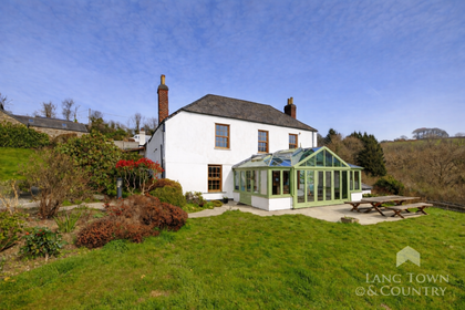
- Price
- Guide Price£1,250,000
- Size
- 21 acres
Morvah, Saltash, Cornwall, Landrake with St. Erney, Cornwall PL12 England
Added on 08/04/2026Farmhouse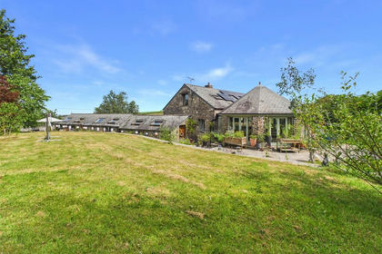
- Price
- £1,100,000
- Size
- 8 acres
Added on 24/07/2026House with Land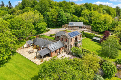
- Price
- £1,100,000
- Size
- 10.5 acres
North Tamerton, Cornwall, North Tamerton, Cornwall EX22 England
Added on 01/09/2026Barn Conversion
- Price
- £1,250,000
- Size
- 15 acres
Thornbury Manor, Thornbury, Holsworthy, EX22, Thornbury, Devon EX22 England
Added on 03/10/2026Country Home
- Price
- Guide Price£1,500,000
- Size
- 10 acres
Penhallow, Truro, Cornwall, TR4, Perranzabuloe, Cornwall TR4 England
Added on 24/05/2026Barn Conversion
- Price
- £1,250,000
- Size
- 13 acres
Broadwoodkelly, Winkleigh, EX19, Broadwoodkelly, Devon EX19 England
Added on 07/03/2026House with Land
- Price
- Guide Price£1,250,000
- Size
- 9 acres
Aveton Gifford, Kingsbridge, Aveton Gifford, Devon TQ7 England
Added on 07/05/2026Country Home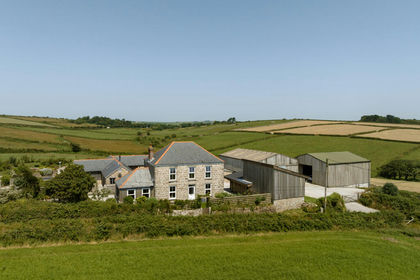
- Price
- Guide Price£1,375,000
- Size
- 10 acres
Added on 21/07/2026House with Land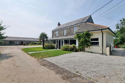
- Price
- Guide Price£1,500,000
- Size
- 11.1 acres
Added on 29/01/2026Smallholding