St Mawgan, TR8
- Land size
- 167 acres
- Bedrooms
- 3
- Bathrooms
- 2
Key Features
- An unspoilt and productive farm extending to approximately 167 acres or 67½ hectares
- Georgian Grade II listed 3-bedroom farmhouse
- Well located and within easy reach of some of Cornwall’s best sandy beaches
- General purpose farm building with lapsed Class Q planning permission
- Stone outbuildings
- Established diversification income
Description
The Property
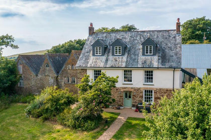
Tolcarne Merock is a Georgian Grade II listed 3-bedroom farmhouse presenting an exceptional opportunity to restore and modernise a well-proportioned period home arranged across two floors. An attached storeroom provides potential for further improvement or extension, subject to the necessary planning consents. Believed to date from the early 19th century, the Farmhouse is set among an attractive collection of traditional stone barns, livestock and machinery buildings, and versatile farmland. Enjoying a peaceful rural position, the farmhouse borders a quiet country lane.
The main farmhouse presents a classic, symmetrical east-facing facade with elegant 16-pane sash windows, set within an historic walled garden and positioned centrally within its own land, the farmhouse affords a high degree of privacy. Low stone garden walls extend from either side of the house, framing the formal gardens and leading around to the rear driveway entrance. These walls, together with the farmhouse and original buildings, form part of the property’s listed status. While the barns are not individually listed, they fall within the curtilage of the listed structures.
Set in a highly desirable location set back from the North Cornish coast at St Mawgan, Tolcarne Merock presents a rare and exciting opportunity to acquire an unspoilt farm, within minutes of the beach, with land, the whole extending to about 167 acres (67½ hectares). The versatile land comprises productive and gently sloping pasture and arable land, contained in well fenced, good size enclosures, with access onto parish roads. The land includes some woodland and offers diversification income from aviation lights located in the field closest to Newquay Airport as well as currently, a telecommunications mast.
Listing
The Farmhouse and attached walls around the walled garden are Grade II Listed (Entry Number: 1327358) Listing NGR: SW
Services
The farm is serviced by mains electricity and water. The farmhouse is connected to mains foul drainage. Oil fired central heating. None of these services have been tested and therefore no guarantees can be given.
Location
Well located and within easy reach of some of Cornwall’s best sandy beaches such as Mawgan Porth and Watergate Bay, Tolcarne Merock also benefits from easy access to the A30 as well as the nearby Newquay Airport. Situated between Padstow and Newquay on the rugged north Cornwall coast, Mawgan Porth offers a golden stretch of sand where fantastic breakers make for excellent surfing. Stunning scenery, several excellent golf courses and spectacular coastal and country walks including those of the renowned Seven Bays, make this hotspot a favourite with locals and visitors alike. The bay itself offers a local store, public house, a surf school and several cafés and eateries, while fine dining can be found at the award-winning Scarlet Hotel, with first class spa and recreational facilities available at The Scarlet & Bedruthan Hotels. Rick Stein's Seafood restaurant, Paul Ainsworth's Michelin starred No.6 and seafood bar Prawn-On-The Lawn can be found just a few miles along the coast in picturesque Padstow. Well situated for ease of transport, Mawgan Porth is less than a 15 -minute drive off the main A30 and just five minutes away from Newquay Airport.
Distances
Newquay airport 1.3 miles, Mawgan Porth 1.5 miles, Watergate Bay 1.7 miles, Newquay 5 miles, Truro 20 miles, Bodmin Parkway Railway station 21 miles. (All distances are approximate.)
what3words///forwarded.kneeled.blatantly.
The Land
The farm extends to about 167 acres (67½ hectares). The productive pasture and arable land are described as mainly Grade III with a small section which is Grade II on the Land Classification Map for the area. The non-productive land includes parcels of woodland, as well as wetland containing ponds in the lower valley towards Mawgan Porth, all providing amenity and/or sporting appeal. Diversification income is generated from aviation warning lights in the field nearest Newquay Airport, along with an existing telecommunications mast. Further details are available from the selling agents.
Wayleaves, Easements & Rights of Way
The property is sold subject to, and with the benefit of, all existing wayleaves, easements and rights of way. Public footpaths cross parts of the farm away from the farmstead (shown coloured pink on the plan).
Outbuildings
To the rear of the house, the yard provides access to a large, detached barn set into the natural slope, with further modern agricultural buildings positioned to the south. Two additional traditional stone outbuildings, one enclosed and one open-fronted, complement the farmstead and offer excellent potential for a variety of uses.
Planning Permissions
Expired Class Q planning for the large general purpose agricultural building, at the top of the farm, for proposed conversion into two dwelling houses REF – PA20/06727
Property Information
Photos: Taken in September 2023 & October 2025
Local Authority: Cornwall Council
Council Tax Band: F
EPC Rating: E
Water source: Direct mains water.
Electricity source: National Grid.
Sewerage arrangements: Standard UK domestic.
Parking Availability: Yes.
Map Location
Property details
- Tenure
- Freehold
- Council Tax Band
- F
- Date Posted
- 2026-01-29
Market Value Analysis
Compared with 22 Farms & Smallholdings listings in South West England (100+ acres).
Utilities & Restrictions
Utilities
- Electricity
- Mains
- Water
- Mains
- Heating
- Ask Agent
- Broadband
- Ask Agent
- Sewerage
- Mains
Rights & Restrictions
- Public Rights of Way
- Ask Agent
- Private Rights of Way
- Ask Agent
- Listed Property
- Ask Agent
- Restrictions
- Ask Agent
Listed status, conservation areas and planning constraints for this location are in the full report.
Property Features
- Accessibility
- Ask Agent
- Parking
- Parking Available
- Garden
- Garden
Beyond the particulars: planning activity, flood history, heritage and ground risks, checked for this exact spot.
Connectivity
Broadband
Fastest speed available at this postcode
1.8 Gbps
Gigabit full fibre
Suitable for
- 4K streaming on every screen
- Full-time home working
- Online gaming & big downloads
Mobile signal
Predicted 4G and 5G signal; indoor signal depends on building materials.
Ofcom Connected Nations postcode-level predictions. Speeds and signal are modelled, not measured, and vary between addresses and providers.
Signal is the easy part. Planning activity, flood history and protected designations here are in the full report.
Nearest Schools
Primary
- Mawgan-In-Pydar Primary School1 mileOfsted: Good
- Ages
- 4 to 11
- Pupils
- 102
- Type
- Academy converter
- Trevisker Primary School2.3 milesNo Ofsted rating
- Ages
- 4 to 11
- Pupils
- 129
- Type
- Academy converter
- St Columb Minor Academy2.9 milesOfsted: Good *
- Ages
- 4 to 11
- Pupils
- 393
- Type
- Academy converter
- Nansledan School3.2 milesOfsted: Good
- Ages
- 4 to 11
- Pupils
- 386
- Type
- Free schools
- Newquay Primary Academy3.4 milesOfsted: Outstanding
- Ages
- 4 to 11
- Pupils
- 132
- Type
- Free schools
Secondary
- Treviglas Academy2.9 milesOfsted: Good *
- Ages
- 11 to 18
- Pupils
- 872
- Type
- Academy sponsor led
- Newquay Tretherras3.3 milesNo Ofsted rating
- Ages
- 11 to 18
- Pupils
- 1,614
- Type
- Academy converter
- Wadebridge School9.5 milesOfsted: Good
- Ages
- 11 to 16
- Pupils
- 1,018
- Type
- Academy converter
- Brannel School10 milesOfsted: Good
- Ages
- 11 to 16
- Pupils
- 888
- Type
- Academy sponsor led
- Poltair School13 milesOfsted: Good
- Ages
- 11 to 16
- Pupils
- 882
- Type
- Academy sponsor led
* Latest graded judgement covers quality of education only; no overall grade was issued under the 2024-25 inspection framework.
Distances are straight-line from the advertised location. Source: the national school registers (DfE, Welsh Government, Scottish Government) and Ofsted.
Schools are just the start: sold prices nearby, planning activity and any flood history are in the full report.
Amenities
Supermarket
GP surgery
Pharmacy
Hospital
Walking trail
Straight-line distances from the advertised location. Sources: NHS records, Geolytix supermarket locations, OS Open Greenspace and the national trails registers.
The area stacks up? Now check the location itself: planning nearby, protected designations and past flooding.
Getting Around
Nearest station
Nearest bus stop
Typical drive times
Straight-line distances from the advertised location; drive times are typical free-flow times over OpenStreetMap road data, so allow more at peak. Public transport locations from DfT NaPTAN.
Easy to reach matters. So do planning activity, flood history and ground risks: all in the full report.
Flood Risk
Environment Agency open data, checked around the advertised map pin for the listed acreage. Long-term risk counts flood defences; the planning map's flood zones do not. Provided by LandSale, not the listing agent, and not part of the agent's particulars. Risk varies across a holding, so verify before committing.
Rivers and the sea
Not at the pin: mapped about 260 metres away.
Planning map: Flood Zone 3, about 260 metres away.
Surface water
Not at the pin: mapped about 50 metres away.
These bandings are the summary. Where this location sits on the flood maps, plus planning activity, heritage and ground risks, is in the full report.
Important notice: Information, maps and tags on this page are drawn from the advertising agent's marketing materials or generated automatically. LandSale has not verified them. Relying on these details is at your own risk, always carry out independent checks before committing to a purchase.
LandSale full disclaimer
Marketing information only - not formal particulars. The details on this website are provided for general guidance and do not constitute an offer or contract. Neither LandSale nor the advertising estate/land agent accepts responsibility for any inaccuracy.
1. Source of information
- Listing content: Core description, asking price, tenure, measurements, photographs and planning history originate from the marketing materials of the advertising estate or land agent. LandSale does not author this content and cannot guarantee its accuracy.
- Automated tags & categorisation: Property type, land-use class, acreage bands and similar labels may be applied by machine-learning models. They are intended as a helpful guide only and may not reflect the property's legal status or permitted use.
- Third-party & enriched data layers: Maps, boundary outlines, planning designations, soil reports, broadband coverage and other environmental or location-based insights are licensed from external suppliers. Such data are supplied “as is", may be incomplete or out of date and are subject to change without notice.
2. Verification required
Prospective purchasers must verify critical matters, including but not limited to planning permission, title boundaries, public rights of way, environmental constraints, acreage, services, access and VAT status, through their own inspections, specialist surveys, legal advisers and the selling agent before relying on the information or entering into any contract.
3. No warranty or liability
LandSale gives no warranty, express or implied, as to the accuracy, completeness or fitness for any particular purpose of the information displayed. LandSale shall not be liable for any loss, damage, cost or expense arising directly or indirectly from any use of or reliance on such information, save where liability may not be excluded by law.
4. Updates & feedback
If you believe any detail on this listing is inaccurate, please let us know. We will investigate and, where appropriate, update the listing or notify the agent.
© LandSale | Version 1.3 - August 2026
Listing agent
John Bray & Partners, Rock
Pavilion Building, Rock, Wadebridge, Cornwall, PL27 6JU
View agent profileSimilar properties for sale
- Price
- Guide Price£1,650,000
- Size
- 11.25 acres
Added on 29/01/2026Development Land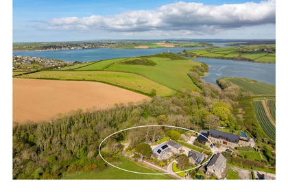
- Price
- Guide Price£2,000,000
- Size
- 1 acres
Added on 29/01/2026Mill Conversion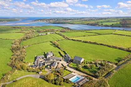
- Price
- Guide Price£3,250,000
- Size
- 1.7 acres
Rock View & Lowen, Higher Halwyn, PL27, St. Issey, Cornwall PL27 England
Added on 25/04/2026Barn Conversion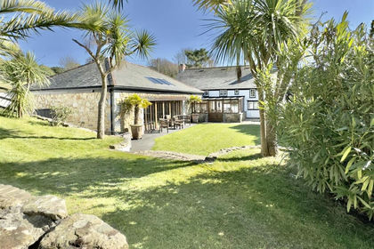
- Price
- Guide Price£2,300,000
- Size
- 2.5 acres
Added on 28/01/2026Country Home
- Price
- Guide Price£1,650,000
- Size
- 9 acres
Added on 29/01/2026Smallholding
- Price
- Guide Price£1,950,000
- Size
- 12 acres
St. Breock, Wadebridge, Cornwall, PL27, St. Breock, Cornwall PL27 England
Added on 29/01/2026House with Land
- Price
- Guide Price£1,750,000
- Size
- 7 acres
Ruthern Valley Holidays, Ruthern Bridge, Bodmin, Cornwall, PL30, Withiel, Cornwall PL30 England
Added on 16/06/2026Holiday Let Property
- Price
- Guide Price£3,750,000
- Size
- 1.5 acres
Whins, New Polzeath, St. Minver Highlands, Cornwall PL27 England
Added on 05/03/2026House with Land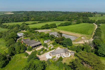
- Price
- Guide Price£2,250,000
- Size
- 78.63 acres
Callestick, Truro, Cornwall, TR4, Perranzabuloe, Cornwall TR4 England
Added on 30/06/2026House with Land
- Price
- Guide Price£2,499,950
- Size
- 7.3 acres
Added on 28/01/2026House with Land